
The Dwight D. Eisenhower National System of Interstate and Defense Highways, commonly known as the Interstate Highway System, is a network of controlled-access highways that forms part of the National Highway System in the United States. The system extends throughout the contiguous United States and has routes in Hawaii, Alaska, and Puerto Rico.

The Arroyo Seco Parkway, also known as the Pasadena Freeway, is one of the oldest freeways built in the United States. It connects Los Angeles with Pasadena alongside the Arroyo Seco seasonal river. It is notable not only for being an early freeway, mostly opened in 1940, but for representing the transitional phase between early parkways and modern freeways. It conformed to modern standards when it was built, but is now regarded as a narrow, outdated roadway. A 1953 extension brought the south end to the Four Level Interchange in downtown Los Angeles and a connection with the rest of the freeway system.

Route 110, consisting of State Route 110 (SR 110) and Interstate 110 (I-110), is a state and auxiliary Interstate Highway in the Los Angeles metropolitan area of the US state of California. The entire route connects San Pedro and the Port of Los Angeles with Downtown Los Angeles and Pasadena. The southern segment from San Pedro to I-10 in downtown Los Angeles is signed as I-110, while the northern segment to Pasadena is signed as SR 110. The entire length of I-110, as well as SR 110 south of the Four Level Interchange with US Route 101 (US 101), is the Harbor Freeway, and SR 110 north from US 101 to Pasadena is the historic Arroyo Seco Parkway, the first freeway in the western United States.
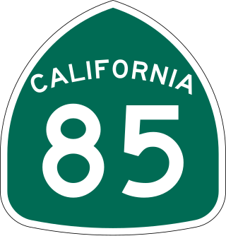
State Route 85 is a state highway which connects the cities of southern San Jose and Mountain View in the U.S. State of California. The highway intersects with major highways such as I-280, SR 17, and SR 87. The route serves as a bypass of U.S. Route 101 in the Santa Clara Valley area, running through the foothill cities of Los Gatos, Saratoga, Cupertino, roughly paralleling the Santa Cruz Mountains up to its interchange with I-280.
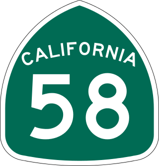
State Route 58 is a major east-west state highway in the U.S. state of California that runs across the Coast Ranges, the southern San Joaquin Valley, the Tehachapi Mountains, which border the southern Sierra Nevada, and the Mojave Desert. It runs between U.S. Route 101 near Santa Margarita and Interstate 15 in Barstow. It has junctions with Interstate 5 near Buttonwillow, State Route 99 in Bakersfield, State Route 202 in Tehachapi, State Route 14 near Mojave, and U.S. Route 395 at Kramer Junction. SR 58 also provides access to Edwards Air Force Base. At various points it is known as the Calf Canyon Highway, Carrisa Highway, Bakersfield-McKittrick Highway, Rosa Parks Highway, Rosedale Highway, Barstow-Bakersfield Highway, Bakersfield Tehachapi Highway, Kern County Korean War Veterans Memorial Highway, and Mojave-Barstow Highway.

State Route 99 (SR 99) is a north–south state highway in the U.S. state of California, stretching almost the entire length of the Central Valley. From its southern end at Interstate 5 (I-5) near Wheeler Ridge to its northern end at SR 36 near Red Bluff, SR 99 goes through the densely populated eastern parts of the valley. Cities served include Bakersfield, Delano, Tulare, Visalia, Fresno, Madera, Merced, Turlock, Modesto, Manteca, Stockton, Sacramento, Yuba City, and Chico.
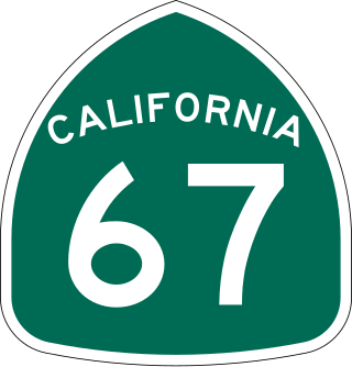
State Route 67 (SR 67) is a state highway in San Diego County, California, United States. It begins at Interstate 8 (I-8) in El Cajon and continues to Lakeside as the San Vicente Freeway before becoming an undivided highway through the eastern part of Poway. In the town of Ramona, the route turns into Main Street before ending at SR 78. SR 67 provides direct access from the city of San Diego to the East County region of San Diego County, including Ramona and Julian.
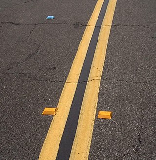
A raised pavement marker is a safety device used on roads. These devices are usually made with plastic, ceramic, thermoplastic paint, glass or occasionally metal, and come in a variety of shapes and colors. Raised reflective markers, such as plastic, ceramic, or metal ones, include a lens or sheeting that enhances their visibility by retroreflecting automotive headlights, while glass road studs gather automotive headlights with a dome shape and reflect the lights with a reflective layer within. Some other names for specific types of raised pavement markers include convex vibration lines, Botts' dots, delineators, cat's eyes, road studs, or road turtles. Sometimes they are simply referred to as "reflectors".

The Manual on Uniform Traffic Control Devices for Streets and Highways is a document issued by the Federal Highway Administration (FHWA) of the United States Department of Transportation (USDOT) to specify the standards by which traffic signs, road surface markings, and signals are designed, installed, and used. In the United States, all traffic control devices must legally conform to these standards. The manual is used by state and local agencies as well as private construction firms to ensure that the traffic control devices they use conform to the national standard. While some state agencies have developed their own sets of standards, including their own MUTCDs, these must substantially conform to the federal MUTCD.

Interstate 205 (I-205) is an east–west auxiliary Interstate Highway in the San Joaquin Valley in Northern California. It runs from I-5 west to I-580. Along with those highways, I-205 forms the north side of a triangle around the city of Tracy. The route provides access from the San Francisco Bay Area to the northern San Joaquin Valley.

Road surface marking is any kind of device or material that is used on a road surface in order to convey official information; they are commonly placed with road marking machines. They can also be applied in other facilities used by vehicles to mark parking spaces or designate areas for other uses. In some countries and areas, road markings are conceived as horizontal traffic signs, as opposed to vertical traffic signs placed on posts.
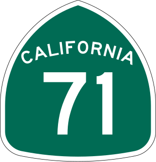
State Route 71 (SR 71) is a 15-mile (24 km) state highway in the U.S. state of California. Serving Riverside, San Bernardino, and Los Angeles counties, it runs from SR 91 in Corona to the Kellogg Interchange with I-10 and SR 57 on the border of Pomona and San Dimas. The segment from SR 91 to SR 83 in Chino Hills is called the Corona Freeway, formerly the Corona Expressway and before then the Temescal Freeway. SR 71 is designated as the Chino Valley Freeway between SR 83 and the Kellogg Interchange.

State Route 4 is a state highway in the U.S. state of California, routed from Interstate 80 in the San Francisco Bay Area to State Route 89 in the Sierra Nevada. It roughly parallels the Sacramento-San Joaquin River Delta, a popular area for boating and fishing, with a number of accesses to marinas and other attractions. After crossing the Central Valley, the highway ascends up the Sierra foothills. It passes through Ebbetts Pass and contains the Ebbetts Pass Scenic Byway, a National Scenic Byway.

Interstate 80 Business, called the Capital City Freeway in its entirety and also known as Business 80, is a business loop of Interstate 80 (I-80) through Sacramento, California, United States. The route is also colloquially referred to as "Cap City Freeway" and "Biz 80". The entire route is a freeway.
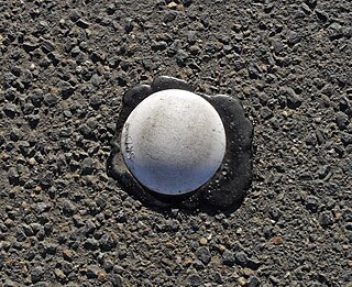
Botts' dots are round non-reflective raised pavement markers. In many parts of the US, Botts' dots are used, along with reflective raised pavement markers, to mark lanes on highways and arterial roads. They provide tactile and auditory feedback to drivers when moving across designated travel lanes, and are analogous to rumble strips.
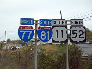
A highway shield or route marker is a sign denoting the route number of a highway, usually in the form of a symbolic shape with the route number enclosed. As the focus of the sign, the route number is usually the sign's largest element, with other items on the sign rendered in smaller sizes or contrasting colors. Highway shields are used by travellers, commuters, and all levels of government for identifying, navigating, and organising routes within a county, state, province, or country. Simplified highway shields often appear on maps.

U.S. Route 50 (US 50) is a transcontinental United States Numbered Highway, stretching from West Sacramento, California, in the west to Ocean City, Maryland, in the east. The California portion of US 50 runs east from Interstate 80 (I-80) in West Sacramento to the Nevada state line in South Lake Tahoe. A portion in Sacramento also has the unsigned designation of Interstate 305. The western half of the highway in California is a four-or-more-lane divided highway, mostly built to freeway standards, and known as the El Dorado Freeway outside of downtown Sacramento. US 50 continues as an undivided highway with one eastbound lane and two westbound lanes until the route reaches the canyon of the South Fork American River at Riverton. The remainder of the highway, which climbs along and out of the canyon, then over the Sierra Nevada at Echo Summit and into the Lake Tahoe Basin, is primarily a two-lane road.
Road signs in Canada may conform to the Manual of Uniform Traffic Control Devices for Canada (MUTCDC) by the Transportation Association of Canada (TAC) for use by Canadian jurisdictions. Although it serves a similar role to the MUTCD from the US Federal Highway Administration, it has been independently developed and has a number of key differences with its American counterpart, most notably the inclusion of bilingual (English/French) signage for jurisdictions such as New Brunswick with significant anglophone and francophone population, and a heavier reliance on symbols rather than text legends.

Terminology related to road transport—the transport of passengers or goods on paved routes between places—is diverse, with variation between dialects of English. There may also be regional differences within a single country, and some terms differ based on the side of the road traffic drives on. This glossary is an alphabetical listing of road transport terms.
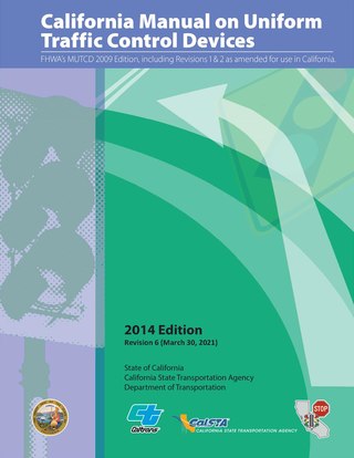
The California Manual on Uniform Traffic Control Devices is the standard for traffic signs, road surface markings, and traffic signals in the U.S. state of California. It is developed by the California Department of Transportation (Caltrans) Division of Safety Programs "in substantial conformance to" the national Manual on Uniform Traffic Control Devices developed by the Federal Highway Administration. The first edition of the CA MUTCD was published in 2006, replacing an earlier supplement to the national MUTCD. The most recent edition was published in 2014, incorporating the 2009 edition of the national MUTCD. California is one of ten states that publish their own editions of the MUTCD. The CA MUTCD defines the content and placement of traffic signs. Design specifications are detailed on a section of the Caltrans website that is based on the national Standard Highway Signs and Markings (SHSM) document.


