Transfusion medicine is the branch of medicine that encompasses all aspects of the transfusion of blood and blood components including aspects related to hemovigilance. It includes issues of blood donation, immunohematology and other laboratory testing for transfusion-transmitted diseases, management and monitoring of clinical transfusion practices, patient blood management, therapeutic apheresis, stem cell collections, cellular therapy, and coagulation. Laboratory management and understanding of state and federal regulations related to blood products are also a large part of the field.

Richmond is a town in New South Wales, in the local government area of the City of Hawkesbury. It is located 19 metres above sea level on the alluvial Hawkesbury River flats, at the foot of the Blue Mountains on the Cumberland Plain. It is about 65 km by road from Sydney and about 78 km by road from Lithgow.
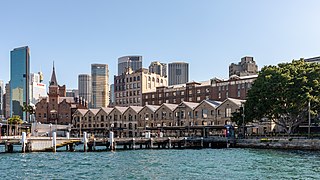
The Rocks is a suburb, tourist precinct and historic area of Sydney's city centre, in the state of New South Wales, Australia. It is located on the southern shore of Sydney Harbour, immediately north-west of the Sydney central business district.

Surry Hills is an inner-east suburb of Sydney, in the state of New South Wales, Australia. Surry Hills is immediately south-east of the Sydney central business district in the local government area of the City of Sydney. Surry Hills is surrounded by the suburbs of Darlinghurst to the north, Chippendale and Haymarket to the west, Moore Park and Paddington to the east and Redfern to the south. It is often colloquially referred to as "Surry".

The Upper Hunter Shire is a local government area in the Upper Hunter Valley of New South Wales, Australia. The Shire was formed in May 2004 from the Scone Shire and parts of Murrurundi and Merriwa shires.

The Royal Prince Alfred Hospital is a large teaching hospital in Sydney, Australia, located on Missenden Road in Camperdown. It is a teaching hospital of the Central Clinical School of the Sydney Medical School at the University of Sydney and is situated in proximity to the Blackburn Building of the university's main campus. RPAH is the largest hospital in the Sydney Local Health District, with approximately 1200 beds. Following a $350 million redevelopment, the perinatal hospital King George V Memorial Hospital has been incorporated into it.

Windsor is a historic town in north-west of Sydney, New South Wales, Australia. It is the council seat of the Hawkesbury local government area. The town sits on the Hawkesbury River, enveloped by farmland and Australian bush. Many of the oldest surviving European buildings in Australia are located at Windsor. It is 46 km (29 mi) north-west of the Sydney CBD, on the fringes of urban sprawl.
Berrima is a historic village in the Southern Highlands of New South Wales, Australia, in Wingecarribee Shire. The village, once a major town, is located on the Old Hume Highway between Sydney and Canberra. It was previously known officially as the Town of Berrima. It is close to the three major towns of the Southern Highlands: Mittagong, Bowral and Moss Vale.

The City of Campbelltown is a local government area in the Macarthur region of south-western Sydney, in New South Wales, Australia. The area is located about 55 kilometres (34 mi) south west of the Sydney central business district and comprises 312 square kilometres (120 sq mi).
Wilberforce is a small town in New South Wales, Australia, in the local government area of the City of Hawkesbury. It is just beyond the outer suburbs of north-west Sydney and lies on the western bank of the Hawkesbury River.

The City of Penrith is a local government area in the state of New South Wales, Australia. The seat of the city is located in Penrith, located about 50 kilometres (31 mi) west of Sydney's central business district. It occupies part of the traditional lands of the Darug people. First incorporated as a municipality on 12 May 1871, on 1 January 1949, the municipalities of Penrith, St Marys and Castlereagh and part of the Nepean Shire amalgamated to form a new Municipality of Penrith. Penrith was declared a City on 21 October 1959, and expanded westwards to include Emu Plains and Emu Heights, formerly part of the City of Blue Mountains, on 25 October 1963. As of the 2021 census the City of Penrith had an estimated population of 217,664.

Millers Point is an inner-city suburb of Sydney, in the state of New South Wales, Australia. It is on the north-western edge of the Sydney central business district, adjacent to The Rocks and is part of the local government area of the City of Sydney.
John Horbury Hunt, often referred to as Horbury Hunt, was a Canadian-born Australian architect who worked in Sydney and rural New South Wales from 1863.
East Maitland is a suburb in Maitland, New South Wales, Australia. It is on the New England Highway and it has two railway stations, Victoria Street and East Maitland. Both stations are served by NSW TrainLink. Hunter Valley Buses provides bus service.

Colonel Walter Liberty Vernon was an English architect who migrated to Australia and pursued his career as an architect in Sydney, New South Wales. In his role as the New South Wales Government Architect he is noted for designing multiple government buildings, many of which are extant with listings on national and state heritage registers.
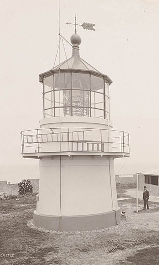
Nobbys Head Light is an active lighthouse on Nobbys Head, a headland on the south side of the entrance to Newcastle Harbour, New South Wales, Australia. An image of the lighthouse is included in the coat of arms of the City of Newcastle.

Albion Street is a street in Sydney, New South Wales, Australia in the local government area of the City of Sydney. It runs east-west from Elizabeth Street to Flinders Street, and is approximately one kilometre long.

The Gunnery, Woolloomooloo is a heritage-listed historic site located at 43–51 Cowper Wharf Road, in the inner city Sydney suburb of Woolloomooloo in the City of Sydney local government area of New South Wales, Australia. It is also known as The Gunnery. The property is owned by the Housing NSW, an agency of the Government of New South Wales. It was added to the New South Wales State Heritage Register on 2 April 1999.
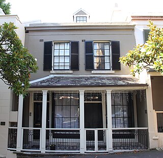
82–84 Windmill Street, Millers Point is a heritage-listed residence and former residence and office located at 82–84 Windmill Street, in the inner city Sydney suburb of Millers Point in the City of Sydney local government area of New South Wales, Australia. It is also known as the Royal College of Pathologists (former) and Terrace. It was added to the New South Wales State Heritage Register on 2 April 1999.
