
The Russian Arctic islands are a number of islands groups and sole islands scattered around the Arctic Ocean.
The Russian Arctic islands are a number of islands groups and sole islands scattered around the Arctic Ocean.
The islands are all situated within the Arctic Circle and are scattered through the marginal seas of the Arctic Ocean, namely, the Barents Sea, Kara Sea, Laptev Sea, East Siberian Sea, Chukchi Sea and Bering Sea. The area extends some 7,000 kilometres (4,300 miles) from Karelia in the west to the Chukchi Peninsula in the east. [1]
The largest of the Arctic islands is Severny Island, with an area of about 48,904 km2 (18,882 sq mi). It is Russia's second largest island next to Sakhalin Island, and the fourth largest island in Europe.
The Russian Empire officially claimed the Arctic islands to its north in a Note of the Russian Government of 20 September 1916 - this covered the islands of Henrietta, Jeannette, Bennett, Herald, Edinenie, New Siberia, Wrangel, Novaya Zemlya, Kolguev, Vaigach and others. [2] On 15 April 1926, the Soviet Union reaffirmed this claim. [2]
The area includes from west to east: [1] [3]

Severnaya Zemlya is a 37,000 km2 (14,000 sq mi) archipelago in the Russian high Arctic. It lies off Siberia's Taymyr Peninsula, separated from the mainland by the Vilkitsky Strait. This archipelago separates two marginal seas of the Arctic Ocean, the Kara Sea in the west and the Laptev Sea in the east.

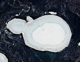
Severny Island is a Russian Arctic island. It is the northern island of the Novaya Zemlya archipelago. It was historically called Lütke Land after Friedrich Benjamin von Lütke, who explored it. It lies approximately 400 km north of the Russian mainland. It has an area of 48,904 square kilometres (18,882 sq mi), making it the 30th-largest island in the world and the 3rd-largest uninhabited island in the world. It is part of Russian Arctic National Park.
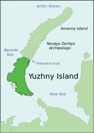
Yuzhny is the southern island of the Novaya Zemlya archipelago, lying north of Russia. It has an area of 33,275 square kilometres (12,800 sq mi), which while smaller than the northern island of Severny, still makes it one of the largest islands in the world. It is separated from Severny Island by the narrow Matochkin Strait, which is covered with ice most of the year. West of Yuzhny Island lies the Barents Sea, to the north the Arctic Ocean, to the east the Kara Sea, and to the south the Pechora Sea.
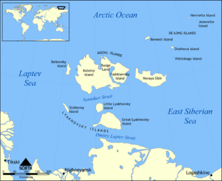
The New Siberian Islands are an archipelago in the Extreme North of Russia, to the north of the East Siberian coast between the Laptev Sea and the East Siberian Sea north of the Sakha (Yakutia) Republic, of which they are administratively a part.

Bolshevik Island is an island in Severnaya Zemlya, Krasnoyarsk Krai, Russian Arctic. The island is named after the political faction of the same name.

The Lyakhovsky Islands are the southernmost group of the New Siberian Islands in the Arctic seas of eastern Russia. The islands are named in honour of Ivan Lyakhov, who explored them in 1773.

Wilczek Land, is an island in the Arctic Ocean at 80.58°N 60.5°E. It is the second-largest island in Franz Josef Land, in Arctic Russia.

The Nordenskiöld Archipelago or Nordenskjold Archipelago is a large and complex cluster of islands in the eastern region of the Kara Sea. Its eastern limit lies 120 km (75 mi) west of the Taymyr Peninsula.

Salm Island is a roughly round-shaped island in Franz Josef Land, Arkhangelsk Oblast, Russia.
Karl Alexander Island, also known as Zemlya Karla-Alexandra, is an island in Franz Josef Land, Russia.

Maly Taymyr Island is an island in the Laptev Sea, Russian Arctic.

The Kirov Islands or Sergey Kirov Islands is an island group in the Kara Sea, Russian Federation. It is an archipelago of small islands covered with tundra vegetation located about 140 km (87 mi) from the coast of Siberia and 100 km (62 mi) northwest of the Nordenskiöld Archipelago.
Eva-Liv Island, alternatively transcribed as Yeva-Liv Island, and also known as Eva Island, is the northeasternmost island in Franz Josef Land, Arkhangelsk Oblast, Russian Arctic.
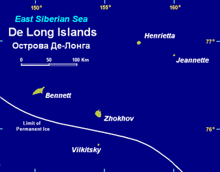
Zhokhov Island is an island in the East Siberian Sea, situated 128 km north east of Novaya Sibir Island, the easternmost of the New Siberian Islands. Administratively the island belongs to the Yakutia administrative division of Russia.

Oleny Island is a single island in the Kara Sea just a few kilometers offshore, north of the coast of one of the arms of the Gyda Peninsula in North Siberia. It is covered with tundra and swamps and it is 53 km in length and its average width is 27 km, having an area of 1197 km². Its latitude is 72° 24' N and the longitude 77° 45' E.

The Plavnikovye Islands is a group of islands, in the Kara Sea eastern region, off the coast of Siberia. These islands are covered with tundra vegetation and there are many lakes and swamps. They are under snow and ice during most of the year.
Starokadomsky Island is an hourglass-shaped island in the Laptev Sea, Russian Arctic.

The Saint Peter Islands, also known as Saint Petra Islands or Petra Islands are two islands covered with tundra vegetation, shingle and ice. These islands, as well as some other islands nearby were originally named after Christian Apostles. The climate is Arctic and severe with frequent blizzards in the winter. The sea surrounding these Islands is covered with fast ice most of the year and is obstructed by pack ice even in the summer, so that these islands are merged with the mainland and animals can go across the ice.
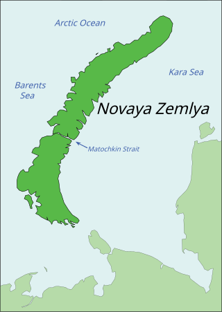
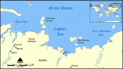
Novaya Zemlya is an archipelago in northern Russia. It is situated in the Arctic Ocean, in the extreme northeast of Europe, with Cape Flissingsky, on the northern island, considered the easternmost point of Europe. To Novaya Zemlya's west lies the Barents Sea and to the east is the Kara Sea.
{{cite web}}: CS1 maint: bot: original URL status unknown (link)