
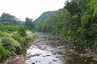
The Mohawk River is a 149-mile-long (240 km) river in the U.S. state of New York. It is the largest tributary of the Hudson River. The Mohawk flows into the Hudson in Cohoes, New York, a few miles north of the state capital of Albany. The river is named for the Mohawk Nation of the Iroquois Confederacy. A major waterway, in the early 19th century, the river's east-west valley provided the setting and water for development of the Erie Canal, as a key to developing New York. The largest tributary, the Schoharie Creek, accounts for over one quarter (26.83%) of the Mohawk River's watershed. Another main tributary is the West Canada Creek, which makes up for 16.33% of the Mohawk's watershed.

A body of water or waterbody is any significant accumulation of water on the surface of Earth or another planet. The term most often refers to oceans, seas, and lakes, but it includes smaller pools of water such as ponds, wetlands, or more rarely, puddles. A body of water does not have to be still or contained; rivers, streams, canals, and other geographical features where water moves from one place to another are also considered bodies of water.
Muncy Creek is a tributary of the West Branch Susquehanna River in Sullivan County and Lycoming County, at Pennsylvania, in the United States. It is approximately 34.5 miles (55.5 km) long. The watershed of the creek has an area of 216 square miles (560 km2). The creek's discharge averages 49 cubic feet per second (1.4 m3/s) at Sonestown, but can be up to a thousand times higher at Muncy. The headwaters of the creek are on the Allegheny Plateau. Rock formations in the watershed include the Chemung Formation and the Catskill Formation.
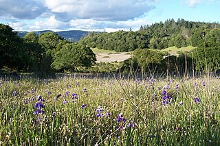
Trione-Annadel State Park is a state park of California in the United States. It is situated at the northern edge of Sonoma Valley and is adjacent to Spring Lake Regional Park in Santa Rosa. It offers many recreational activities within its 5,092-acre (2,061 ha) property.
Pyramid Creek Falls Provincial Park is a provincial park in British Columbia, Canada, located on the east side of the North Thompson River between the towns of Blue River (S) and Valemount (N).

Nescopeck Creek is a 37.5-mile-long (60.4 km) tributary of the Susquehanna River in Luzerne County, Pennsylvania. The creek is in the Coal Region of Pennsylvania. The meaning of the creek's name is "deep black waters". The waters of Nescopeck Creek have difficulty ratings between Class I and Class III. However, during parts of the year, Nescopeck Creek is impossible to navigate due to rapids, flooding, and tight bends. Nescopeck Creek is home to a number of species of trout, although the waters are not always optimal for them. Nescopeck Creek's water is acidic, with a pH as low as 3.6 in some studies.

Osmiridium and iridosmine are natural alloys of the elements osmium and iridium, with traces of other platinum-group metals.

Wiconisco Creek is a tributary of the Susquehanna River in Schuylkill and Dauphin counties, Pennsylvania, in the United States. It is approximately 45.5 miles (73.2 km) long.

Bowman Creek is a tributary of the Susquehanna River in Luzerne County and Wyoming County, in Pennsylvania, in the United States. It is approximately 26 miles (42 km) long and flows through Ross Township and Lake Township in Luzerne County and Noxen Township, Monroe Township, and Eaton Township in Wyoming County. The watershed of the creek has an area of 120 square miles (310 km2). The creek is not designated as an impaired waterbody and its pH is close to neutral, although it has experienced some problems with acid rain. It has low concentrations of dissolved solids like calcium. The creek is relatively small in its upper reaches, but by Noxen, its width is 40 to 60 feet. It is also relatively shallow in many reaches. Rock formations in the watershed include the Catskill Formation, the Huntley Mountain Formation, Burgoon Sandstone, the Mauch Chunk Formation, the Pottsville Group, and the Pocono Formation. Soil associations in the creek's watershed include the Wellsboro-Morris-Oquaga association, the Oquaga-Lackawanna-Arnot association, the Mardin-Bath-Volusia association, and the Wyoming-Pope association.

Chillisquaque Creek is a tributary of the West Branch Susquehanna River in Montour County and Northumberland County, in Pennsylvania, in the United States. It is approximately 20.2 miles (32.5 km) long and flows through Derry Township, Washingtonville, and Liberty Township in Montour County and East Chillisquaque Township and West Chillisquaque Township in Northumberland County. The watershed of the creek has an area of 112 square miles (290 km2). Agricultural impacts have caused most of the streams in the watershed of the creek to be impaired. Causes of impairment include sedimentation/siltation and habitat alteration. The average annual discharge of the creek between 1980 and 2014 ranged from 48.2 to 146.0 cubic feet per second. Its watershed mainly consists of rolling agricultural land. The creek's channel flows through rock formations consisting of sandstone and shale. It is a warmwater stream.

Bear Creek is a ski resort in Longswamp Township, Pennsylvania, in the Lehigh Valley region of eastern Pennsylvania. The resort opened in 1967 and was known as the Doe Mountain until 1999. It is a year-round resort on more than 330 acres (1.3 km2) that features a variety of activities and amenities.

Buffalo Creek is a tributary of the West Branch Susquehanna River in Union County, Pennsylvania, in the United States. It is approximately 28.5 miles (45.9 km) long and flows through Hartley Township, Lewis Township, West Buffalo Township, Mifflinburg, Buffalo Township, Kelly Township, and Lewisburg. Its watershed has an area of 134 square miles (350 km2). It is in the ridge-and-valley province of the Appalachian Mountains. Some streams and parts of streams in the creek's watershed are high-quality cold-water fisheries. There are ten types of rock formations and eight types of soil series in the watershed. The forests in the Buffalo Creek watershed are mostly deciduous hardwood, hemlock, and pine.

Roaring Creek is a tributary of the Susquehanna River in Columbia County and Montour County, in Pennsylvania, in the United States. It is slightly more than 20 miles (32 km) long and flows through Roaring Creek Township, Locust Township, Catawissa Township, Cleveland Township, and Franklin Township in Columbia County and Mayberry Township in Montour County. The watershed of the creek has an area of 87.3 square miles (226 km2). It has three named tributaries: South Branch Roaring Creek, Lick Run, and Mill Creek. The creek is not considered to be impaired and is not affected by coal mining. However, its watershed has been impacted by human land use. Claystones, conglomerates, sandstones, siltstones, and shales all occur within the watershed. The creek flows through a gorge in its lower reaches, along the border between Columbia County and Montour County.
Goose Creek Memorial High School is a public high school in an unincorporated area of Harris County, Texas, United States, and is located north of Baytown. Goose Creek Memorial is one of the three public high schools in the Goose Creek Consolidated Independent School District and was built to accommodate the growing population of northern Goose Creek CISD. It was opened with grades 9 to 11 for the 2008–2009 school year, adding students in grade 12 the following year. In 2011, the school was rated "Academically Acceptable" by the Texas Education Agency.

Novato Creek is a stream in eastern Marin County, California, United States. It originates in highlands between Red Hill and Mount Burdell above the city of Novato, California, and flows 17 miles (27 km) before emptying into San Pablo Bay south of Petaluma Point.

A total solar eclipse will occur on Monday, August 22, 2044. A solar eclipse occurs when the Moon passes between Earth and the Sun, thereby totally or partly obscuring the image of the Sun for a viewer on Earth. A total solar eclipse occurs when the Moon's apparent diameter is larger than the Sun's, blocking all direct sunlight, turning day into darkness. Totality occurs in a narrow path across Earth's surface, with the partial solar eclipse visible over a surrounding region thousands of miles wide.

West Branch Chillisquaque Creek is a tributary of Chillisquaque Creek. Its watershed spans parts of Northumberland, Montour, Lycoming, and Columbia counties in Pennsylvania. West Branch Chillisquaque Creek is about five miles long. The creek is home to a number of tree species and herb species. There are also five main types of rock formations and four main types of soil in the creek's watershed.
East Branch Fishing Creek is a tributary of Fishing Creek in Columbia County and Sullivan County, Pennsylvania, in the United States. It is 4.4 miles (7.1 km) long. The stream and its tributaries are acidic and contain aluminum. The area in the vicinity was first settled in the late 18th century.
Lower Little Swatara Creek is a tributary of Swatara Creek in southern Schuylkill County, Pennsylvania, US. The creek is 11 miles (18 km) long. The creek starts on Blue Mountain and flows west-southwest into Swatara Creek near the community of Pine Grove. Fishing and canoeing are the primary recreational activities on the creek. Significant amounts of phosphorus and sediment flow through the creek.
The Bland Creek, a mostly–perennial river that is part of the Lachlan sub-catchment of the Murrumbidgee catchment within the Murray–Darling basin, is located in the South West Slopes, and Riverina regions of New South Wales, Australia. The Bland Creek is only connected to the Murray Darling basin when both the Lachlan and Murrumbidgee Rivers are in flood.
