Related Research Articles

A Doppler radar is a specialized radar that uses the Doppler effect to produce velocity data about objects at a distance. It does this by bouncing a microwave signal off a desired target and analyzing how the object's motion has altered the frequency of the returned signal. This variation gives direct and highly accurate measurements of the radial component of a target's velocity relative to the radar.
Ultra-wideband is a radio technology that can use a very low energy level for short-range, high-bandwidth communications over a large portion of the radio spectrum. UWB has traditional applications in non-cooperative radar imaging. Most recent applications target sensor data collection, precision locating and tracking applications. UWB support started to appear in high-end smartphones c. 2019.
Identification, friend or foe (IFF) is an identification system designed for command and control. It uses a transponder that listens for an interrogation signal and then sends a response that identifies the broadcaster. IFF systems usually use radar frequencies, but other electromagnetic frequencies, radio or infrared, may be used. It enables military and civilian air traffic control interrogation systems to identify aircraft, vehicles or forces as friendly and to determine their bearing and range from the interrogator. IFF is used by both military and civilian aircraft. IFF was first developed during World War II, with the arrival of radar, and several friendly fire incidents.

Synthetic-aperture radar (SAR) is a form of radar that is used to create two-dimensional images or three-dimensional reconstructions of objects, such as landscapes. SAR uses the motion of the radar antenna over a target region to provide finer spatial resolution than conventional stationary beam-scanning radars. SAR is typically mounted on a moving platform, such as an aircraft or spacecraft, and has its origins in an advanced form of side looking airborne radar (SLAR). The distance the SAR device travels over a target during the period when the target scene is illuminated creates the large synthetic antenna aperture. Typically, the larger the aperture, the higher the image resolution will be, regardless of whether the aperture is physical or synthetic – this allows SAR to create high-resolution images with comparatively small physical antennas. For a fixed antenna size and orientation, objects which are further away remain illuminated longer - therefore SAR has the property of creating larger synthetic apertures for more distant objects, which results in a consistent spatial resolution over a range of viewing distances.

Electromagnetic interference (EMI), also called radio-frequency interference (RFI) when in the radio frequency spectrum, is a disturbance generated by an external source that affects an electrical circuit by electromagnetic induction, electrostatic coupling, or conduction. The disturbance may degrade the performance of the circuit or even stop it from functioning. In the case of a data path, these effects can range from an increase in error rate to a total loss of the data. Both man-made and natural sources generate changing electrical currents and voltages that can cause EMI: ignition systems, cellular network of mobile phones, lightning, solar flares, and auroras. EMI frequently affects AM radios. It can also affect mobile phones, FM radios, and televisions, as well as observations for radio astronomy and atmospheric science.
Imaging radar is an application of radar which is used to create two-dimensional images, typically of landscapes. Imaging radar provides its light to illuminate an area on the ground and take a picture at radio wavelengths. It uses an antenna and digital computer storage to record its images. In a radar image, one can see only the energy that was reflected back towards the radar antenna. The radar moves along a flight path and the area illuminated by the radar, or footprint, is moved along the surface in a swath, building the image as it does so.
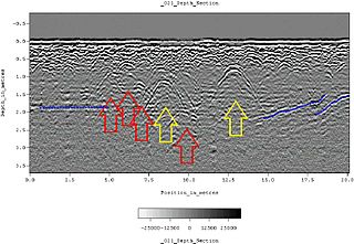
Ground-penetrating radar (GPR) is a geophysical method that uses radar pulses to image the subsurface. It is a non-intrusive method of surveying the sub-surface to investigate underground utilities such as concrete, asphalt, metals, pipes, cables or masonry. This nondestructive method uses electromagnetic radiation in the microwave band of the radio spectrum, and detects the reflected signals from subsurface structures. GPR can have applications in a variety of media, including rock, soil, ice, fresh water, pavements and structures. In the right conditions, practitioners can use GPR to detect subsurface objects, changes in material properties, and voids and cracks.
Electronic counter-countermeasures (ECCM) is a part of electronic warfare which includes a variety of practices which attempt to reduce or eliminate the effect of electronic countermeasures (ECM) on electronic sensors aboard vehicles, ships and aircraft and weapons such as missiles. ECCM is also known as electronic protective measures (EPM), chiefly in Europe. In practice, EPM often means resistance to jamming.

The AN/FPS-16 is a highly accurate ground-based monopulse single object tracking radar (SOTR), used extensively by the NASA manned space program, the U.S. Air Force and the U.S. Army. The accuracy of Radar Set AN/FPS-16 is such that the position data obtained from point-source targets has azimuth and elevation angular errors of less than 0.1 milliradian and range errors of less than 5 yards (5 m) with a signal-to-noise ratio of 20 decibels or greater.
Radar engineering details are technical details pertaining to the components of a radar and their ability to detect the return energy from moving scatterers — determining an object's position or obstruction in the environment. This includes field of view in terms of solid angle and maximum unambiguous range and velocity, as well as angular, range and velocity resolution. Radar sensors are classified by application, architecture, radar mode, platform, and propagation window.
Radar MASINT is a subdiscipline of measurement and signature intelligence (MASINT) and refers to intelligence gathering activities that bring together disparate elements that do not fit within the definitions of signals intelligence (SIGINT), imagery intelligence (IMINT), or human intelligence (HUMINT).

Radio is the technology of signaling and communicating using radio waves. Radio waves are electromagnetic waves of frequency between 30 hertz (Hz) and 300 gigahertz (GHz). They are generated by an electronic device called a transmitter connected to an antenna which radiates the waves, and received by another antenna connected to a radio receiver. Radio is very widely used in modern technology, in radio communication, radar, radio navigation, remote control, remote sensing, and other applications.

Leo C. Young was an American radio engineer who had many accomplishments during a long career at the U.S. Naval Research Laboratory. Although self-educated, he was a member of a small, creative team which some attributed to the developing the world's first true radar system.
The Unified S-band (USB) system is a tracking and communication system developed for the Apollo program by NASA and the Jet Propulsion Laboratory (JPL). It operated in the S band portion of the microwave spectrum, unifying voice communications, television, telemetry, command, tracking and ranging into a single system to save size and weight and simplify operations. The USB ground network was managed by the Goddard Space Flight Center (GSFC). Commercial contractors included Collins Radio, Blaw-Knox, Motorola and Energy Systems.

Counter-IED equipment are created primarily for military and law enforcement. They are used for standoff detection of explosives and explosive precursor components and defeating the Improvised Explosive Devices (IEDs) devices themselves as part of a broader counter-terrorism, counter-insurgency, or law enforcement effort.
One way of outlining the subject of radio science is listing the topics associated with it by authoritative bodies.
High Resolution Wide Swath (HRWS) imaging is an important branch in Synthetic aperture radar (SAR) imaging, a remote sensing technique capable of providing high resolution images independent of weather conditions and sunlight illumination. This makes SAR very attractive for the systematic observation of dynamic processes on the Earth's surface, which is useful for environmental monitoring, earth resource mapping and military systems.
The railSAR, also known as the ultra-wideband Foliage Penetration Synthetic Aperture Radar, is a rail-guided, low-frequency impulse radar system that can detect and discern target objects hidden behind foliage. It was designed and developed by the U.S. Army Research Laboratory (ARL) in the early 1990s in order to demonstrate the capabilities of an airborne SAR for foliage and ground penetration. However, since conducting accurate, repeatable measurements on an airborne platform was both challenging and expensive, the railSAR was built on the rooftop of a four-story building within the Army Research Laboratory compound along a 104-meter laser-leveled track.
The boomSAR is a mobile ultra-wideband synthetic aperture radar system designed by the U.S. Army Research Laboratory (ARL) in the mid-1990s to detect buried landmines and IEDs. Mounted atop a 45-meter telescoping boom on a stable moving vehicle, the boomSAR transmits low frequency short-pulse UWB signals over the side of the vehicle to scope out a 300-meter range area starting 50 meters from the base of the boom. It travels at an approximate rate of 1 km/hour and requires a relatively flat road that is wide enough to accommodate its 18 ft-wide base.
The Spectrally Agile Frequency-Incrementing Reconfigurable (SAFIRE) radar is a vehicle-mounted, forward-looking ground-penetrating radar (FLGPR) system designed to detect buried or hidden explosive hazards. It was developed by the U.S. Army Research Laboratory (ARL) in 2016 as part of a long generation of ultra-wideband (UWB) and synthetic aperture radar (SAR) systems created to combat buried landmines and IEDs. Past iterations include the railSAR, the boomSAR, and the SIRE radar.
References
- 1 2 3 4 Ojowu, Ode (April 30, 2013). Ranney, Kenneth I; Doerry, Armin (eds.). "SIRE: A MIMO Radar for Landmine/IED Detection". Howard University. Radar Sensor Technology XVII. 8714: 87140O. Bibcode:2013SPIE.8714E..0OO. doi:10.1117/12.2015618. S2CID 1552558. Archived from the original on June 18, 2017 – via Defense Technical Information Center.
- 1 2 3 4 Ressler, Marc; Nguyen, Lam; Koenig, Francois; Wong, David; Smith, Gregory (2007). Gerhart, Grant R; Gage, Douglas W; Shoemaker, Charles M (eds.). "The Army Research Laboratory (ARL) synchronous impulse reconstruction (SIRE) forward-looking radar". Unmanned Systems Technology IX. 6561: 656105. Bibcode:2007SPIE.6561E..05R. doi:10.1117/12.719688. S2CID 109944483.
- 1 2 3 Nguyen, Lam (April 2009). "Signal and Image Processing Algorithms for the U.S. Army Research Laboratory Ultra-wideband (UWB) Synchronous Impulse Reconstruction (SIRE) Radar" (PDF). Army Research Laboratory.
- ↑ Saponaro, Philip; Kambhamettu, Chandra; Ranney, Kenneth; Sullivan, Anders (May 31, 2013). Ranney, Kenneth I; Doerry, Armin (eds.). "Concealed target detection using augmented reality with SIRE radar". Radar Sensor Technology XVII. 8714: 87140S. Bibcode:2013SPIE.8714E..0SS. doi:10.1117/12.2015133. S2CID 121659957.
- ↑ Dogaru, Traian (March 2019). "Imaging Study for Small Unmanned Aerial Vehicle (UAV)-Mounted Ground-Penetrating Radar: Part I – Methodology and Analytic Formulation" (PDF). CCDC Army Research Laboratory. ARL-TR-8654.
- ↑ Phelan, Brian; Ranney, Kenneth; Gallagher, Kyle; Clark, John; Sherbondy, Kelly; Narayanan, Ram (July 15, 2017). "Design of Ultrawideband Stepped-Frequency Radar for Imaging of Obscured Targets". IEEE Sensors Journal. 17 (14): 4435–4446. Bibcode:2017ISenJ..17.4435P. doi:10.1109/JSEN.2017.2707340. ISSN 1558-1748. S2CID 12721792.
- 1 2 Dogaru, Traian (August 2015). "A Huygens Surface Approach to Antenna Implementation in Near-Field Radar Imaging System Simulations". U.S. Army Research Laboratory.