Sabirabad District

Last updated
Sabirabad District
Sabirabad District in Azerbaijan 2021.svg
Map of Azerbaijan showing Sabirabad District
Country Flag of Azerbaijan.svg  Azerbaijan
Region Mil-Mughan
Established8 August 1930
Capital Sabirabad
Settlements [1] 75
Government
   Governor Siragaddin Jabbarov
Area
  Total1,470 km2 (570 sq mi)
Population
 (2020) [2]
  Total178,800
  Density120/km2 (320/sq mi)
Time zone UTC+4 (AZT)
Postal code
5400
Website sabirabad-ih.gov.az

Sabirabad District (Azerbaijani : Sabirabad rayonu) is one of the 66 districts of Azerbaijan. Located in the centre of the country, it belongs to the Mil-Mughan Economic Region. The district borders the districts of Saatly, Imishli, Kurdamir, Hajigabul, Salyan, Bilasuvar, and the city of Shirvan. Its capital and largest city is Sabirabad. As of 2020, the district had a population of 178,800. [2]

Contents

History

The area of Sabirabad is rich with ancient monuments and settlements. As a result of the excavation in the district, ancient necropolis as well as settlements which belong to V-I, V-II, and I B.C were found in Surra, Javad, Abdulyan, Garatepe, Guruzma, Garagashil, Bulagli, Zangana and Galagayin. Materials that were found in the “Shahargah” place of the village show that the ancient findings belong to the 11th-12th centuries. Historically, some nations attacked Mughan lands known as “Khaver Zemin”, “Guneshli land”. However, all those pressures were overcome. Since that time, “Khaver Zamin” replaced with Galagayin. Currently, the Sabirabad district has Galagayin village.

The biggest village in the district is Javad which has been a historical city and the centre of the Javad Khanate. Javad became part of Quba Khanate in 1768. When Azerbaijan became a part of Russia, a number of Russians were settled in Javad. The district was named Petropavlovka in 1988.

Sabirabad district was organized on August 8, 1930. On October 7, 1931, Petropavlokva was renamed after the famous Azerbaijani satirical poet M.A.Sabir with the decree of the Azerbaijan Central Executive Committee. On May 25, 1943, Saatli District turned into an integral part of Sabirabad. The Saatli district was joined to Sabirabad on January 4, 1963, and it continued until January 14, 1965. The downtown was renamed a town-type settlement on November 7, 1952, and since December 4, 1959, the district has been called Sabirabad. [3]

Geography

The district is located in the south of Mugan plain. [4] Rayon borders upon Kurdamir Rayon in the north for a distance of 30 km, Shamakhi Rayon in the north-west for a distance of 5 km, Shirvan city in the south for a distance of 24 km, Salyan Rayon in the south-west for a distance of 48 km, Bilasuvar Rayon in the south for a distance of 18 km, Saatly Rayon in the east for a distance of 136 km and Imishli Rayon for a distance of 8 km. Its length from the north to the south is 66 km, and from the east to the west is 24 km. A part of the rayon's territory is on the right coast of the Kura River, in Shirvan plain. [5]

The low-lying area is dependent on canals and dams whose damage during 2010 caused waters from Lake Sarisu to flood several of the region's villages. [6] [7]

Population

According to the State Statistics Committee, as of 2018, the population of city recorded 174,800 persons, which increased by 36400 persons (about 26 percent) from 138,400 persons in 2000. [8] 87,800 of total population are men, 87000 are women. [9] More than 13 percent of the population (about 46,6 persons) consists of young people and teenagers aged 14–29. [10]

Population of district by the year (at the beginning of the year, thsd. persons) [8]
Region2000200120022003200420052006200720082009201020112012201320142015201620172018
Sabirabad region138,4139,8140,6141,4142,3143,9145,7147,9149,7151,2153,1155,4158,9161,9164,6167,5170,3172,7174,8
urban population27,427,527,527,627,727,928,028,128,228,228,428,629,029,229,429,830,230,530,6
rural population111,0112,3113,1113,8114,6116,0117,7119,8121,5123,0124,7126,8129,9132,7135,2137,7140,1142,2144,2

Population distribution by ethnicity according to 2009 census: [11]

Ethnic groupsQuantity
Azerbaijani148571
Turkish81
Lezgin3
Talysh2
Ukrainian2
Kurds2
Georgian1

Transport

Sabirabad Road Sabirabad - 4.jpg
Sabirabad Road

There are 3rd and 4th category railways in the district. The roads lengthen 522 km. The country indicator is 7.9 percent. The republican significance motorway lengthens 243 km. The country indicator is 8.6%. The highway lengthens 279 km. The country indicator is 7.8 percent. Rail transport is also widely used in the region.

Historical monuments

One of the oldest monuments on Sabirabad is Bad Samid's tomb, which was built in the 16th century. Another old monument is Mosque Galayagin which belongs to the 17th century, the Shemakha Mosque which was built in 1903. [12]

Notable natives

Economy

2018 wheat production:

In 2018, the economic growth was equal to 39,221 thousand manats. The main sector in this region is primary. GDP of this region is 437244 manat. Production of production is equal to 18169,4 tones. [13]

Related Research Articles

<span class="mw-page-title-main">Neftchala District</span> District of Azerbaijan

Neftchala District is one of the 66 districts of Azerbaijan. It is located in the southeast of the country and belongs to the Shirvan-Salyan Economic Region. The district borders the districts of Jalilabad, Bilasuvar, Salyan, Lankaran, and Masally. Its capital and largest city is Neftchala. As of 2020, the district had a population of 88,900.

<span class="mw-page-title-main">Zardab District</span> District of Azerbaijan

Zardab District is one of the 66 districts of Azerbaijan. It is located in the centre of the country and belongs to the Central Aran Economic Region. The district borders the districts of Agdash, Ujar, Kurdamir, Imishli, Beylagan, Aghjabadi, and Barda. Its capital and largest city is Zardab. As of 2020, the district had a population of 59,300.

<span class="mw-page-title-main">Ujar District</span> District of Azerbaijan

Ujar District is one of the 66 districts of Azerbaijan. It is located in the centre of the country and belongs to the Central Aran Economic Region. The district borders the districts of Agdash, Goychay, Kurdamir, and Zardab. Its capital and largest city is Ujar. As of 2020, the district had a population of 89,500.

<span class="mw-page-title-main">Agdash District</span> District of Azerbaijan

Agdash District is one of the 66 districts of Azerbaijan. It is located in the centre of the country, in the Central Aran Economic Region. The district borders the districts of Yevlakh, Shaki, Oghuz, Qabala, Goychay, Ujar, Zardab, and Barda. Its capital and largest city is Agdash. As of 2020, the district had a population of 111,100.

<span class="mw-page-title-main">Bilasuvar District</span> District of Azerbaijan

Bilasuvar District is one of the 66 districts of Azerbaijan. It is located in the south-east of the country, in the Shirvan-Salyan Economic Region. The district borders the districts of Imishli, Saatly, Sabirabad, Salyan, Neftchala, Jalilabad, and Ardabil Province of Iran. Its capital and largest city is Bilasuvar. As of 2020, the district had a population of 105,100.

<span class="mw-page-title-main">Beylagan District</span> District of Azerbaijan

Beylagan District is one of the 66 districts of Azerbaijan. It is located in the centre of the country and belongs to the Mil-Mughan Economic Region. It borders the districts of Fuzuli, Aghjabadi, Zardab, Imishli, and the Ardabil Province of Iran. Its capital and largest city is Beylagan. As of 2020, the district had a population of 99,500.

<span class="mw-page-title-main">Kurdamir District</span> District of Azerbaijan

Kurdamir district is one of the 66 districts of Azerbaijan. Located in the centre of the country, it belongs to the Central Aran Economic Region. The district borders the districts of Zardab, Ujar, Goychay, Ismayilli, Agsu, Hajigabul, Sabirabad, and Imishli. Its capital and largest city is Kurdamir. As of 2020, the district had a population of 117,900.

<span class="mw-page-title-main">Imishli District</span> District of Azerbaijan

Imishli District is one of the 66 districts of Azerbaijan. It is located in the centre of the country and belongs to the Central Aran Economic Region. The district borders the districts of Beylagan, Zardab, Kurdamir, Sabirabad, Saatly, Bilasuvar, and the Ardabil Province of Iran. Its capital and largest city is Imishli. As of 2020, the district had a population of 158,682.

<span class="mw-page-title-main">Qusar District</span> District of Azerbaijan

Qusar District is one of the 66 districts of Azerbaijan. It is located in the northeast of the country, in the Guba-Khachmaz Economic Region. The district borders the districts of Quba, Qabala, Khachmaz, and the Russian Republic of Dagestan. Its capital and largest city is Qusar. As of 2020, the district had a population of 99,000.

<span class="mw-page-title-main">Saatly District</span> District of Azerbaijan

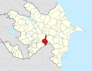
Saatly District is one of the 66 districts of Azerbaijan. It is located in the centre of the country, belonging to the Central Aran Economic Region. The district borders the districts of Imishli, Sabirabad, and Bilasuvar. Its capital and largest city is Saatly. As of 2020, the district had a population of 109,100.

<span class="mw-page-title-main">Yardimli District</span> District of Azerbaijan

Yardimli District is one of the 66 districts of Azerbaijan. It is located in the south-east of the country and belongs to the Lankaran-Astara Economic Region. The district borders the districts of Jalilabad, Masally, Lerik, and the Ardabil Province of Iran. Its capital and largest city is Yardimli. As of 2020, the district had a population of 68,000.

<span class="mw-page-title-main">Kurdamir</span> City and municipality in Azerbaijan

Kurdamir is a city and the capital of the Kurdamir District of Azerbaijan. It is located in Aran Economic Region. The city's population is 18,100 people.

<span class="mw-page-title-main">Outline of Azerbaijan</span> Country in the Caucasus region of Eurasia

The following outline is provided as an overview of and topical guide to Azerbaijan:

<span class="mw-page-title-main">Qalaqayın</span> Municipality in Sabirabad, Azerbaijan

Qalaqayın is a village and the most populous municipality, except for the capital Sabirabad, in the Sabirabad Rayon of Azerbaijan. It has a population of 7,658.
The fortress of the historic Javad Khanate and the center of the Mughan district.

<span class="mw-page-title-main">Sabirabad (city)</span> Place in Sabirabad, Azerbaijan

Sabirabad is the capital city of the Sabirabad District of Azerbaijan. The city was renamed in honor of the poet Mirza Alakbar Sabir. Sabirabad is the administrative center of Sabirabad District of the Republic of Azerbaijan. In 1935, the district received the status of subordinate city. Sabirabad is located on the right bank of the Kura River. In the vicinity of the city of Sugovushan, the Araz River is merged with the Kur River.

<span class="mw-page-title-main">Salyan, Azerbaijan</span> City in Salyan, Azerbaijan

Salyan, is a city and the capital of the Salyan District of Azerbaijan. The city of Salyan is industrialized and known for processing caviar.

<span class="mw-page-title-main">Aran Economic Region</span> Former economic region in Azerbaijan

Aran Economic Region was one of the 10 economic regions of Azerbaijan. It bordered Iran to the south, as well as the economic regions of Upper Karabakh, Ganja-Gazakh, Shaki-Zagatala, Mountainous Shirvan, Absheron, and Lankaran. The region consisted of the districts of Agdash, Aghjabadi, Barda, Beylagan, Bilasuvar, Jalilabad, Goychay, Hajigabul, Imishli, Kurdamir, Neftchala, Saatly, Sabirabad, Salyan, Ujar, Yevlakh, Zardab and the cities of Mingachevir and Shirvan.

<span class="mw-page-title-main">Mil-Mughan Economic Region</span> Economic region of Azerbaijan

Mil-Mughan Economic Region is one of the 14 economic regions of Azerbaijan. It borders Iran to the south, as well as the economic regions of Shirvan-Salyan, Central Aran, and Karabakh. The region consists of the districts of Beylagan, Imishli, Saatly, and Sabirabad. It has an area of 5,670 square kilometres (2,190 sq mi). Its population was estimated to be 522,600 in January 2021.

<span class="mw-page-title-main">Shirvan-Salyan Economic Region</span> Economic region of Azerbaijan

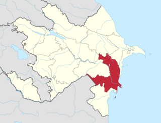
Shirvan-Salyan Economic Region is one of the 14 economic regions of Azerbaijan. It borders Iran to the west, as well as the economic regions of Mil-Mughan, Central Aran, Mountainous Shirvan, Absheron-Khizi, Baku, and Lankaran-Astara. The region consists of the districts of Bilasuvar, Hajigabul, Neftchala, Salyan, as well as the city of Shirvan. It has an area of 6,080 square kilometres (2,350 sq mi). Its population was estimated to be at 501.3 thousand people in January 2021.

References

  1. "İnzibati-ərazi vahidləri" (PDF). preslib.az. Retrieved 28 February 2021.
  2. 1 2 "Population of Azerbaijan". stat.gov.az. State Statistics Committee . Retrieved 22 February 2021.
  3. "Tarixi - SABİRABAD RAYON Icra Hakimiyyəti". www.sabirabad-ih.gov.az. Retrieved 2018-12-21.
  4. "Sabirabad Rayon". discoverazerbaijan.az. Archived from the original on 2013-09-11.
  5. "Sabirabad Rayon". azerbaijan.az. Archived from the original on 2018-10-18. Retrieved 2012-08-21.
  6. "Number of flood-hit villages in Sabirabad region increases". www.today.az.
  7. Sarisu waters burst through dam Archived 2012-03-11 at the Wayback Machine
  8. 1 2 "Political division, population size and structure: Population by towns and regions of the Republic of Azerbaijan". The State Statistical Committee of the Republic of Azerbaijan. Retrieved 2018-12-18.
  9. "Political division, population size and structure: Population by sex, towns and regions, urban settlements of the Republic of Azerbaijan at the beginning of the 2018". The State Statistical Committee of the Republic of Azerbaijan. Retrieved 2018-12-18.
  10. "Political division, population size and structure: Population at age 14-29 by towns and regions of the Republic of Azerbaijan at the beginning of the 2018". The State Statistical Committee of the Republic of Azerbaijan. Retrieved 2018-12-18.
  11. "Ethnic composition of Azerbaijan 2009". pop-stat.mashke.org. Retrieved 2019-05-10.
  12. "AZƏRBAYCAN QEYRİ-MADDİ MƏDƏNİ İRS NÜMUNƏLƏRİNİN DÖVLƏT REYESTRİ". intangible.az. Archived from the original on 2019-03-06. Retrieved 2019-05-10.
  13. "İqtisadiyyat - SABİRABAD RAYON Icra Hakimiyyəti". www.sabirabad-ih.gov.az. Retrieved 2019-05-10.

40°0′N48°36′E / 40.000°N 48.600°E / 40.000; 48.600