Saint-Aventin

Last updated

Saint-Aventin
Saint-Aventin village.JPG
A general view of Saint-Aventin
Blason ville fr Saint-Aventin (Haute-Garonne).svg
Location of Saint-Aventin
Saint-Aventin
France location map-Regions and departements-2016.svg
Red pog.svg
Saint-Aventin
Languedoc-Roussillon-Midi-Pyrenees region location map.svg
Red pog.svg
Saint-Aventin
Coordinates: 42°48′26″N0°32′49″E / 42.8072°N 0.5469°E / 42.8072; 0.5469
Country France
Region Occitania
Department Haute-Garonne
Arrondissement Saint-Gaudens
Canton Bagnères-de-Luchon
Government
  Mayor (20202026) Jean-Claude Tiné [1]
Area
1
17.4 km2 (6.7 sq mi)
Population
 (Jan. 2020) [2]
62
  Density3.6/km2 (9.2/sq mi)
Time zone UTC+01:00 (CET)
  Summer (DST) UTC+02:00 (CEST)
INSEE/Postal code
31470 /31110
Elevation679–2,676 m (2,228–8,780 ft)
(avg. 929 m or 3,048 ft)
1 French Land Register data, which excludes lakes, ponds, glaciers > 1 km2 (0.386 sq mi or 247 acres) and river estuaries.

Saint-Aventin is a commune in the Haute-Garonne department in southwestern France.

Contents

The commune of Saint-Aventin is located in the heart of the Pyrenees, and extends from the Larboust Valley in the north to the Spanish border in the South. The highest point is the Sacroux peek at 2,676 metres. The municipal territory hosts the Luchon-Superbagnères winter sports facilities, accessible only from Bagnères-de-Luchon by road or Cable car. The village of Saint-Aventin, is located in the Larboust Valley, 52 km south of Saint-Gaudens and 5km west of Bagnères-de-Luchon. The population density is 5.3per/km²

Population

Historical population
YearPop.±%
1793242    
1800176−27.3%
1806259+47.2%
1821340+31.3%
1831386+13.5%
1841400+3.6%
1846415+3.8%
1851410−1.2%
1856390−4.9%
1861410+5.1%
1866360−12.2%
1878320−11.1%
1886295−7.8%
1891282−4.4%
1896284+0.7%
1901283−0.4%
YearPop.±%
1906288+1.8%
1911291+1.0%
1921228−21.6%
1926224−1.8%
1931208−7.1%
1936200−3.8%
1946195−2.5%
1954162−16.9%
1962128−21.0%
1968155+21.1%
1975149−3.9%
1982115−22.8%
199098−14.8%
199996−2.0%
200888−8.3%
201192+4.5%
Source: EHESS [3]

Land Marks

Saint Aventin Church

The Romanesque Church Saint-Aventin dates from the 11th or 12th century, has two bell towers, a porch decorated with sculptures, and capitals showing scenes of the life and martyrdom of saint Aventin.
The exterior walls have incorporated stone from previous buildings that reuse of stelae and pagan altars dedicated to Pyrenean gods, including Abellio and Aherbelst. Inside the church are monumental paintings, a baptismal font and a wrought iron altar. The Church has been classified historical monument since 1840. [4]

See also

Related Research Articles

<span class="mw-page-title-main">Haute-Garonne</span> Department of France in Occitanie

Haute-Garonne is a department in the Occitanie region of Southwestern France. Named after the river Garonne, which flows through the department. Its prefecture and main city is Toulouse, the country's fourth-largest. In 2019, it had a population of 1,400,039.

<span class="mw-page-title-main">Bagnères-de-Luchon</span> Commune in Occitania, France

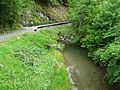
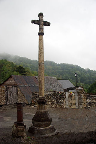
Bagnères-de-Luchon, also referred to as just Luchon, is a commune and spa town in the Haute-Garonne department in the Occitanie region of south-western France.

<span class="mw-page-title-main">Luz-Saint-Sauveur</span> Commune in Occitania, France

Luz-Saint-Sauveur is a commune in the Hautes-Pyrénées department in the Occitania region of south-western France. It lies on the river Bastan, a tributary of the Gave de Pau. Locals simply call it Luz, the city took its current name from Luz-Saint-Sauveur on April 9, 1962. Its inhabitants are called Luzéens and Luzéennes in French. The town features locations of historical heritage such as the church of Saint-André, also known as "Les Templiers", the Château Sainte-Marie or the spa district. Protected by mountains to the east, west and south, and separated from the plain to the north by the Pierrefitte gorge, Luz-Saint-Sauveur is somewhat geographically isolated though it is only a 12 hour drive from Lourdes.

<span class="mw-page-title-main">Arrondissement of Saint-Gaudens</span> Arrondissement in Occitania, France

The arrondissement of Saint-Gaudens is an arrondissement of France in the Haute-Garonne department in the Occitanie region. It has 235 communes. Its population is 77,444 (2016), and its area is 2,139.6 km2 (826.1 sq mi).

The following is a list of the 27 cantons of the Haute-Garonne department, in France, following the French canton reorganisation which came into effect in March 2015:

<span class="mw-page-title-main">Aurignac</span> Commune in Occitania, France

Aurignac is a commune in the Haute-Garonne department in southwestern France, close to the Pyrénées. It was the seat of the former canton of Aurignac, which was composed of 19 communes. It is part of the ancient region known as the Comminges.

<span class="mw-page-title-main">Col de Peyresourde</span> Mountain pass in France

The Col de Peyresourde is a mountain pass in the central Pyrenees on the border of the department of Haute-Garonne and Hautes-Pyrénées in France. It is situated on the D618 road between Bagnères-de-Luchon and Arreau.

<span class="mw-page-title-main">Antras, Ariège</span> Commune in Occitanie, France

Antras is a commune in the Ariège department in the Occitanie region of southwestern France.

<span class="mw-page-title-main">Antichan-de-Frontignes</span> Commune in Occitania, France

Antichan-de-Frontignes is a commune in the Haute-Garonne department in the Occitanie region of south-western France.

<span class="mw-page-title-main">Montauban-de-Luchon</span> Commune in Occitania, France

Montauban-de-Luchon is a commune in the Haute-Garonne department of southwestern France.

<span class="mw-page-title-main">Venerque</span> Commune in Occitania, France

Venerque is a commune in the Haute-Garonne department in southwestern France. Venerque-le-Vernet station has rail connections to Toulouse, Foix and Latour-de-Carol.

<span class="mw-page-title-main">Labège</span> Commune in Occitania, France

Labège is a commune in the Haute-Garonne department in the Occitania region in Southwestern France. In 2019, it had a population of 4,008.

<span class="mw-page-title-main">Castillon-de-Larboust</span> Commune in Occitania, France

Castillon-de-Larboust is a commune in the Haute-Garonne department in southwestern France.

<span class="mw-page-title-main">Azet</span> Commune in Occitania, France

Azet is a commune in the Hautes-Pyrénées department in the Occitanie region of south-western France.

<span class="mw-page-title-main">Beaudéan</span> Commune in Occitania, France

Beaudéan is a commune in the Hautes-Pyrénées department in the Occitanie region of south-western France.

<span class="mw-page-title-main">Superbagnères</span>

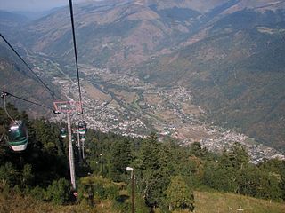
Superbagnères is a ski resort above the town of Bagnères-de-Luchon in the French department of Haute-Garonne in the Midi-Pyrénées region.

<span class="mw-page-title-main">Pic de Maupas</span>

The pic de Maupas is a central pyrenean summit, culminating at 3,109 m (10,200 ft) on the Franco-Spanish border.

The 2014 Tour de France was the 101st edition of the race, one of cycling's Grand Tours. It featured 22 cycling teams. The Tour started in Yorkshire, England on 5 July and finished on the Champs-Élysées in Paris on 27 July.

<span class="mw-page-title-main">Aventin</span>

Saint Aventin was a French Saint and a hermit of the 8th century.

The canton of Bagnères-de-Luchon is an administrative division of the Haute-Garonne department, southern France. Its borders were modified at the French canton reorganisation which came into effect in March 2015. Its seat is in Bagnères-de-Luchon.

References

  1. "Répertoire national des élus: les maires". data.gouv.fr, Plateforme ouverte des données publiques françaises (in French). 9 August 2021.
  2. "Populations légales 2020". The National Institute of Statistics and Economic Studies. 29 December 2022.
  3. Des villages de Cassini aux communes d'aujourd'hui: Commune data sheet Saint-Aventin, EHESS (in French).
  4. Base Mérimée : PA00094445 , Ministère français de la Culture. (in French)