
Anyuysky National Park covers the basin of the Anyuy River, on the west slope of the Central Sikhote-Alin Mountain range in the Russian Far East. The Anyuy flows west into the Amur River, the main river of the region, as it flows northeast into the Sea of Okhotsk. The park is important because it creates an ecological corridor from the low floodplain of the Amur, to the high forested mountains of the Sikhote-Alin. The park is in the Nanaysky District in Khabarovsk Krai, about 50 miles downstream of the city of Khabarovsk. The area is remote, with few towns and sparse population. The area has historically depended on salmon fishing, logging, and hunting. The local indigenous people are the Nanai people, representing about a quarter of the nearby settlements.

Udegeyskaya Legenda National Park covers the richest coniferous-deciduous forest on the western slope of the Central Sikhote-Alin mountains of the Russian Far East. The Sikhote-Alin is a range that runs north-south through Primorsky Krai. The park is designed to protect west-slope river valley habitat, and to support the remnant of the indigenous Udege people. The area is known for abundant fishing and boating on the streams and rivers. It is also a refuge for the endangered Amur tiger. The park is roughly midway between the city of Vladivostok, and Khabarovsk. The relatively warm waters of the Sea of Japan are to the east, the Korean peninsula to the south, and China to the West.
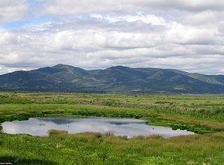
Bureya Nature Reserve is a protected area (Zapovednik) about 200 km northwest of the city of Khabarovsk, in the Verkhnebureinsky District of Khabarovsk Krai, in the Russian Far East. The territory is one of mountain tundra, rivers and lakes, and taiga forests. It includes the headwaters of the left and right tributaries of the Bureya River, part of the lower Amur River basin. The reserve was created in 1987, and covers an area of 358,444 ha (1,383.96 sq mi).
Olyokma Nature Reserve is a Russian 'zapovednik' located south of the middle reaches of the Lena River on the right bank of its second largest tributary - the Olyokma River at the junction of the Aldan Highlands and the Olyokma-Chara Plateau in Olyokminsky District of the Sakha Republic (Yakutia). The area is remote and relatively undisturbed, being 80 km from a town.
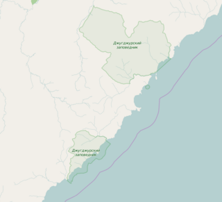
Dzhugdzursky Nature Reserve is a Russian 'zapovednik' on the coast of the Sea of Okhotsk, on the territory of Ayano-Maisky region of the Khabarovsk Territory in the Russian Far East. With over 8,000 km2 of land area and over 500 km2 of marine area, it is the largest of the six nature reserves in Khabarovsk Krai. It supports spawning streams into the Okhotsk Sea for chum, pink salmon and coho salmon.

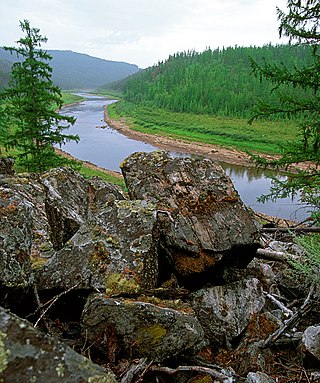
Komsomolsk Nature Reserve is a Russian 'zapovednik', encompassing the confluence of the Gorin River and the Amur River in the Russian Far East. The reserve protects a meeting zone of multiple ecoregions in the lower Amur, including the northernmost reach of Manchurian taiga. It is located about 50 km downstream (east) of Komsomolsk-on-Amur, in the Komsomolsky District of Khabarovsk Krai. The reserve was created in 1963, and covers an area of 64,278 ha (248.18 sq mi).
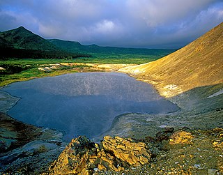
Kurils Nature Reserve is a Russian 'zapovednik' covering the north and south portions of Kunashir Island, the largest and most southernmost of the Kuril Islands, which stretch between Hokkaido Island in Japan to the Kamchatka peninsula in the Russia Far East. It also covers two smaller islands nearby to the southeast. The area is one of the largest wintering sites for coastal seabirds. The reserve sits on a tectonically unstable location, and is one of two Russian national reserves that protects territory of active volcanoes. The reserve is situated in the Yuzhno-Kurilsky District of Sakhalin Oblast. The reserve was created in 1984, and covers an area of 65,364 ha (252.37 sq mi).

Botcha Nature Reserve is a Russian 'zapovednik'. It is the northernmost reserve inhabited by the endangered Amur Tiger. The reserve is located in the north-eastern part of the Sikhote-Alin mountain range; it includes the Botchi River basin on its eastern slopes. The reserve is about 120 km south of the port city of Sovetskaya Gavan in the Sovetsko-Gavansky District of Khabarovsk Krai. The reserve was created in 1994, and covers an area of 267,380 ha (1,032.4 sq mi).
The Transbaikal conifer forests ecoregion covers a 1,000 km by 1,000 km region of mountainous southern taiga stretching east and south from the shores of Lake Baikal in the Southern Siberia region of Russia, and including part of northern Mongolia. Historically, the area has been called "Dauria", or Transbaikal. It is in the Palearctic realm, and mostly in the boreal forests/taiga biome with a subarctic, humid climate. It covers 200,465 km2 (77,400 sq mi).

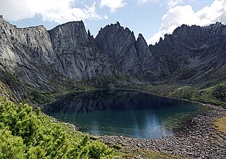
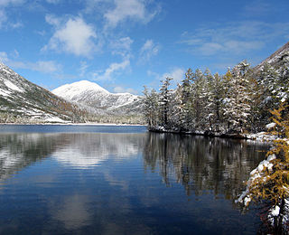
Dzherginsky Nature Reserve is a Russian 'zapovednik', located about 100 km east of the northern section of Lake Baikal. It covers the source and upper reaches of the Barguzin River, the second largest tributary to Lake Baikal, and is at the junction of three mountain ranges - the Barguzin Range to the west of the reserve, the Ikat Range and the Southern Muya Range. The reserve's mountainous territory is dominated by larch forests. It is situated in the Kurumkansky District of Buryatia. The nearest city, Ulan-Ude, is 560 km to the south. The reserve was formally established in 1992 to protect the biodiversity of the upper Barguzin valley, and to study natural processes of the area. It covers an area of 238,088 hectares (919.26 sq mi).

Poronaysky Nature Reserve is a Russian 'zapovednik' covering Cape Patience, on the eastern side of Sakhalin Island in the Russian Far East. A specific purpose of the reserve is to protect rookeries for arctic birds on Cape Patience, which is a 65 km peninsula extending into the Okhotsk Sea. The reserve includes the southern part of the East Sakhalin Mountains, and the widest part of the Tym-Poronaisk dale. The reserve is situated in the Poronaysky District of Sakhalin Oblast, 50 km east of the regional city of Poronaysk. It was formally established in 1988, and covers 56,695 ha (218.90 sq mi).

The West Siberian taiga ecoregion covers the West Siberian Plain in Russia, from the Ural mountains in the west to the Yenisei River in the east, and roughly from 56° N to 66° N latitude. It is a vast, flat lowland region of boreal forests (taiga), and wetlands, covering an area about 1,800 km west–east, by 1,000 km north–south.

The Northeast Siberian taiga ecoregion is an area of "sparse taiga forest" between the Lena River and the Kolyma River in northeastern Siberia, Russia. The ecoregion's internal borders form a patchwork of territory constituting the southern part of the East Siberian Lowland, as well as lowlands around the East Siberian Mountains, including the ridges and peaks of the Verkhoyansk Range and the Chersky Range. On the southern border of the ecoregion is the north coast of the Sea of Okhotsk, giving the region maritime boreal forests as well as the continental forests situated inland. The ecoregion is one of the largest tracts of virgin boreal forest in the world, due to the very sparse population and difficult access. It is mostly in the Sakha Republic.
The Okhotsk-Manchurian taiga ecoregion is an area of coniferous forests in the Russian Far East, covering the Amur River delta, the west coast of the Okhotsk Sea, and the rugged extension of the northern Sikhote-Alin Mountains that run southwest-to-northeast through the Primorsky and Khabarovsk regions. It is the southernmost taiga forest in Eurasia. The ecoregion is distinguished from surrounding ecoregions by the slightly warmer climate due to the maritime influence and the shield of the mountains to the west, and by the mixing of flora and fauna species from Okhotsk-Kamchatka communities to the north and Manchurian species from the south. The forest at lower altitudes is "light taiga", and "dark taiga" at higher altitudes.
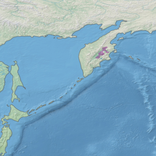
The Kamchatka Taiga ecoregion is a "conifer island" in the middle of the Kamchatka Peninsula, along the Kamchatka River. It is the easternmost example of Siberian taiga. The region has unusual ecological conditions, a "snow forest" that combines low temperatures, high humidity and boreal forest with heavy snowfall. The local ecology is also affected by volcanic activity. The region is about 300 km long (north–south), and averages about 100 km west–east. It is in the Palearctic realm, and mostly in the Boreal forests/taiga ecoregion with a humid continental climate, cool summer climate. It covers 147,064 km2 (56,782 sq mi).

The Kamchatka-Kurile meadows and sparse forests ecoregion covers the coastal zones of the Kamchatka peninsula, northern section of the Kuril Islands, and the Commander Islands in the Russian Far East. The region noted for its sparse forests of Betula ermanii, and also for extensive tall-herb meadows. It is in the Palearctic realm, and mostly in the boreal forests/taiga biome with a Humid continental climate, cool summer climate. It covers 146,334 km2 (56,500 sq mi).

The Sayan montane conifer forests ecoregion covers the mid-elevation levels of the Sayan Mountains, the high mountain range between the taiga of Siberia, Russia to the north, and the steppes of Mongolia to the south. The slopes of the mountains at the mid-altitudes are covered by Temperate coniferous forest. The ecoregion is in the Palearctic realm, with a cold semi-arid climate. It covers 35,741,835 km2 (13,800,000 sq mi).

The Ussuri broadleaf and mixed forests ecoregion covers a mountainous areas above the lower Amur River and Ussuri River in Primorsky Krai and Khabarovsk Krai in the Russian Far East. The ecoregion is in the Palearctic realm, with a Humid Continental climate. It covers 187,357 km2 (72,339 sq mi).

The South Sakhalin-Kurile mixed forests ecoregion is split between the southwest region of Sakhalin Island, and the southern three islands of the Kurile Islands chain in the Russian Far East. The ecoregion is in the Palearctic realm, with a Humid Continental climate. It covers 12,432 km2 (4,800 sq mi).

The Hokkaidō deciduous forests ecoregion covers the northern and southern coasts of the island of Hokkaido, the northernmost of the main islands of Japan. The region sits in the transition zone between the colder subarctic forests to the north and the more temperate forests to the south. Characteristic trees include Mongolian oak, Basswood, and Ash trees.


