Related Research Articles

John McLoughlin, baptized Jean-Baptiste McLoughlin, was a French-Canadian, later American, Chief Factor and Superintendent of the Columbia District of the Hudson's Bay Company at Fort Vancouver from 1824 to 1845. He was later known as the "Father of Oregon" for his role in assisting the American cause in the Oregon Country. In the late 1840s, his general store in Oregon City was famous as the last stop on the Oregon Trail.

Fort Vancouver was a 19th century fur trading post that was the headquarters of the Hudson's Bay Company's Columbia Department, located in the Pacific Northwest. Named for Captain George Vancouver, the fort was located on the northern bank of the Columbia River in present-day Vancouver, Washington. The fort was a major center of the regional fur trading. Every year trade goods and supplies from London arrived either via ships sailing to the Pacific Ocean or overland from Hudson Bay via the York Factory Express. Supplies and trade goods were exchanged with a plethora of Indigenous cultures for fur pelts. Furs from Fort Vancouver were often shipped to the Chinese port of Guangzhou where they were traded for Chinese manufactured goods for sale in the United Kingdom. At its pinnacle, Fort Vancouver watched over 34 outposts, 24 ports, six ships, and 600 employees. Today, a full-scale replica of the fort, with internal buildings, has been constructed and is open to the public as Fort Vancouver National Historic Site.

The Fraser River is the longest river within British Columbia, Canada, rising at Fraser Pass near Blackrock Mountain in the Rocky Mountains and flowing for 1,375 kilometres (854 mi), into the Strait of Georgia just south of the City of Vancouver. The river's annual discharge at its mouth is 112 cubic kilometres (27 cu mi) or 3,550 cubic metres per second (125,000 cu ft/s), and each year it discharges about 20 million tons of sediment into the ocean.

Oregon Country was a large region of the Pacific Northwest of North America that was subject to a long dispute between the United Kingdom and the United States in the early 19th century. The boundaries of the area, which had been created by the Treaty of 1818 without recognizing indigenous claims to the area, consisted of the land north of 42° N latitude, south of 54°40′ N latitude, and west of the Rocky Mountains down to the Pacific Ocean and east to the Continental Divide. Article III of the 1818 treaty gave joint control to both nations for ten years, allowed land to be claimed, and guaranteed free navigation to all mercantile trade. However, both countries disputed the terms of the international treaty. Oregon Country was the American name while the British used Columbia District for the region. Meanwhile, Indigenous nations had lived in the area since time immemorial, though with little legal recognition in the American and British legal systems. Evidence along the Salmon River shows people lived there at least 16,000 years ago, and may have populated the continent after migrating along the Pacific Coast, then following up the Columbia River into the interior.

Alexander Caulfield Anderson was a British Hudson's Bay Company (HBC) fur-trader, explorer of British Columbia and civil servant.

Fort Nisqually was an important fur trading and farming post of the Hudson's Bay Company in the Puget Sound area, part of the Hudson's Bay Company's Columbia Department. It was located in what is now DuPont, Washington. Today it is a living history museum located in Tacoma, Washington, USA, within the boundaries of Point Defiance Park. The Fort Nisqually Granary, moved along with the Factor's House from the original site of the second fort to this park, is a U.S. National Historic Landmark. Built in 1843, the granary is the oldest building in Washington state and one of the only surviving examples of a Hudson's Bay Company "post-and-plank" structure. The Factor's House and the granary are the only surviving Hudson's Bay Company buildings in the United States.

Fort Langley is a village community in Township of Langley, British Columbia, Canada. It has a population of approximately 3,400 people. It is the home of Fort Langley National Historic Site, a former fur trade post of the Hudson's Bay Company. Lying on the Fraser River, Fort Langley is at the northern edge of the Township of Langley.
The Stave River is a tributary of the Fraser, joining it at the boundary between the municipalities of Maple Ridge and Mission, about 35 kilometres (22 mi) east of Vancouver, British Columbia, Canada, in the Central Fraser Valley region.

The Columbia District was a fur trading district in the Pacific Northwest region of British North America in the 19th century. Much of its territory overlapped with the disputed Oregon Country. It was explored by the North West Company between 1793 and 1811, and established as an operating fur district around 1810. The North West Company was absorbed into the Hudson's Bay Company in 1821 under which the Columbia District became known as the Columbia Department. The Oregon Treaty of 1846 marked the effective end of the Hudson's Bay Company's Columbia Department.
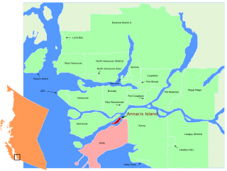
Annacis Island is a narrow island under the jurisdiction of City of Delta in Lower Mainland, British Columbia, located just downstream of the south arm of the Fraser River bifurcation between Lulu Island to the north and the Delta peninsula to the south. The island is now mostly an industrial zone, and contains one of Metro Vancouver's secondary wastewater treatment plants, the Annacis Island Wastewater Treatment Plant. The island is also home to the British Columbia Institute of Technology's Annacis Island campus.
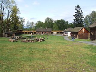
Fort Langley National Historic Site, commonly shortened to Fort Langley, is a former fur trading post of the Hudson's Bay Company in the community of Fort Langley of Langley, British Columbia, Canada. The national historic site sits above the banks of the Bedford Channel across McMillan Island. The national historic site contains a visitor centre and a largely reconstructed trading post that contains ten structures surrounded by wooden palisades.

Fort Okanogan was founded in 1811 on the confluence of the Okanogan and Columbia Rivers as a fur trade outpost. Originally built for John Jacob Astor’s Pacific Fur Company, it was the first American-owned settlement within Washington state, located in what is now Okanogan County. The North West Company, the PFC's primary competitor, purchased its assets and posts in 1813. In 1821 the North West Company was merged into Hudson's Bay Company, which took over operation of Fort Okanogan as part of its Columbia District. The fort was an important stop on the York Factory Express trade route to London via Hudson Bay.
The Nicomekl River springs from the ground in Langley, British Columbia and travels west through the city to Surrey's Crescent Beach, where it empties into Mud Bay, the northernmost section of the Boundary Bay of the Strait of Georgia. It has a total length of 34 km, with a drainage area of 149 km2.
Fort William was a fur trading outpost built in 1834 by the American Nathaniel Jarvis Wyeth, a Boston merchant, backed by American investors. It was located on the Columbia River on Wappatoo Island near the future Portland, Oregon. After a few years, in 1837 Wyeth sold the post to the British Hudson's Bay Company, which had much more power in the region from its base at Fort Vancouver on the north side of the Columbia River near Fort William.
James McMillan was a fur trader and explorer for the North West Company and Hudson's Bay Company. He led some of the earliest surveys of the lower Fraser River and founded Fort Langley for the HBC in 1827, and was its first Chief Trader.
McMillan Island is an island in the Fraser River, British Columbia, Canada, also known as McMillan Slough..

James Murray Yale was a clerk, and later, a Chief trader for the Hudson's Bay Company, during the late North American fur trade, as they were competing with the Montreal-based North West Company and the American Fur Company of John Jacob Astor. During his career, he would negotiate and compete with Americans, French Canadians, Russians, and Indians for market shares. He is best remembered for having given his name to Fort Yale, British Columbia, which became the city of Yale during the gold rush, and later on, became the name of the Yaletown district of downtown Vancouver.

Fort Pelly was a Hudson's Bay Company fur trading post located in the Canadian province of Saskatchewan. The fort was named after Sir John Pelly, governor of the Hudson's Bay Company. The current village of Pelly, Saskatchewan, takes its name from the fort, and is located approximately 8 miles north of the site of the fort.
Fort Stikine was a fur trade post and fortification in what is now the Alaska Panhandle, at the site of the present-day of Wrangell, Alaska. Originally built as the Redoubt San Dionisio or Redoubt Saint Dionysius in 1834, the site was transferred to the British-owned Hudson's Bay Company as part of a lease signed in the region in 1838, and renamed Fort Stikine when turned into a Hudson's Bay Company post in 1839. The post was closed and decommissioned by 1843 but the name remained for the large village of the Stikine people which had grown around it, becoming known as Shakesville in reference to its ruling Chief Shakes by the 1860s. With the Alaska Purchase of 1867, the fortification became occupied by the US Army and was renamed Fort Wrangel, a reference to Baron von Wrangel, who had been Governor of Russian America when the fort was founded. The site today is now part of the city of Wrangell.
Bruce Alastair McKelvie was a Canadian journalist and historian. He signed his books as B.A. McKelvie.
References
- ↑ BC Names/GeoBC entry "Salmon River"
- ↑ Salmon River Enhancement Society
- ↑ Salmon River Enhancement Society
- ↑ McKelvie, Bruce Alistair "Fort Langley, Outpost of Empire". The Vancouver Daily Province. 1947
- ↑ http://parkscanadahistory.com/publications/langley/outpost-of-empire.pdf
49°10′37″N122°35′11″W / 49.17694°N 122.58639°W