Newburg is a former census-designated place in Jefferson County, Kentucky, United States. The population was 20,636 at the 2000 census. On January 6, 2003, the area was annexed to the city of Louisville due to a merger between the city and Jefferson County's unincorporated communities. Newburg is now thought to be a neighborhood within the now merged city of Louisville.

Cumberland County is a county in the Commonwealth of Pennsylvania. As of the 2020 census, the population was 259,469. Its county seat is Carlisle.

Atkinson is an unincorporated community in Center Township, Benton County, in the U.S. state of Indiana. The site of Atkinson is home to the county's only junior/senior high school, Benton Central.

Johnson is an unincorporated town and Census designated place in Montgomery Township, Gibson County, Indiana, United States. It is located roughly four miles west of Owensville and eight miles north of Poseyville.
Perth is an unincorporated community in Dick Johnson Township, Clay County, Indiana. It is part of the Terre Haute Metropolitan Statistical Area.
Turner is an unincorporated community in Posey Township, Clay County, Indiana. It is part of the Terre Haute Metropolitan Statistical Area.
Beard is an unincorporated community in Warren Township, Clinton County, Indiana.
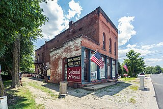
Warrenton is an unincorporated community in Johnson Township, Gibson County, Indiana. Warrenton is home to The Log Inn, the oldest restaurant in Indiana. The community is located immediately northeast of the US 41-I-64 interchange.
Bud is an unincorporated community in Union Township, Johnson County, Indiana.
Kinder is an unincorporated community in White River Township, Johnson County, Indiana.
Nineveh is an unincorporated community in Nineveh Township, Johnson County, Indiana, United States.
Old Bargersville is an unincorporated community in Union Township, Johnson County, Indiana.
Peoga is an unincorporated community in Brown and Johnson counties, in the U.S. state of Indiana.
Providence is an unincorporated community in Union Township, Johnson County, Indiana.
Rocklane is an unincorporated community in Clark Township, Johnson County, Indiana.
Urmeyville is an unincorporated community in Needham Township, Johnson County, Indiana.
Smith Valley is an unincorporated community in White River Township, Johnson County, Indiana.
Purcell is an unincorporated community in Johnson Township, Knox County, Indiana.
Woodruff is an unincorporated community in Johnson Township, LaGrange County, Indiana.
Vida is an unincorporated community in Phelps County, Missouri, United States. Vida is approximately six miles south of Rolla, near the junction of US Highway 63 and Missouri Route W. Vida is located at an elevation of 1033 feet above sea level. Vida can be found on Phelps County plat maps in Section 10, Township 36 N, Range 9 W.


