Pago Pago is the territorial capital of American Samoa. It is in Maoputasi County on Tutuila, which is American Samoa's main island.
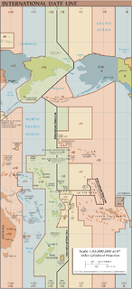
The International Date Line (IDL) is an internationally accepted demarcation on the surface of Earth, running between the South Pole and North Pole and serving as the boundary between one calendar day and the next. It passes through the Pacific Ocean, roughly following the 180° line of longitude and deviating to pass around some territories and island groups. Crossing the date line eastbound decreases the date by one day, while crossing the date line westbound increases the date.

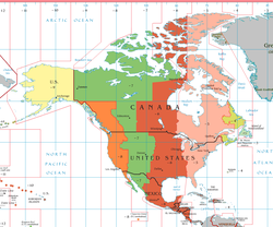
The Pacific Time Zone (PT) is a time zone encompassing parts of western Canada, the western United States, and western Mexico. Places in this zone observe standard time by subtracting eight hours from Coordinated Universal Time (UTC−08:00). During daylight saving time, a time offset of UTC−07:00 is used.
The Alaska Time Zone observes standard time by subtracting nine hours from Coordinated Universal Time (UTC−09:00). During daylight saving time its time offset is eight hours (UTC−08:00). The clock time in this zone is based on mean solar time at the 135th meridian west of the Greenwich Observatory.
The Hawaii–Aleutian Time Zone observes Hawaii–Aleutian Standard Time (HST) by subtracting ten hours from Coordinated Universal Time (UTC−10:00). The clock time in this zone is based on the mean solar time of the 150th meridian west of the Greenwich Observatory.
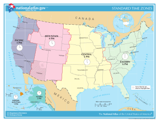
Time in the United States, by law, is divided into nine standard time zones covering the states, territories and other US possessions, with most of the United States observing daylight saving time (DST) for approximately the spring, summer, and fall months. The time zone boundaries and DST observance are regulated by the Department of Transportation. Official and highly precise timekeeping services (clocks) are provided by two federal agencies: the National Institute of Standards and Technology (NIST) ; and the United States Naval Observatory (USNO). The clocks run by these services are kept synchronized with each other as well as with those of other international timekeeping organizations.
Time in New Zealand is divided by law into two standard time zones. The main islands use New Zealand Standard Time (NZST), 12 hours in advance of Coordinated Universal Time (UTC) / military M (Mike), while the outlying Chatham Islands use Chatham Standard Time (CHAST), 12 hours 45 minutes in advance of UTC / military M^ (Mike-Three).
The Newfoundland Time Zone (NT) is a geographic region that keeps time by subtracting 3.5 hours from Coordinated Universal Time (UTC) during standard time, resulting in UTC−03:30; or subtracting 2.5 hours during daylight saving time. The clock time in this zone is based on the mean solar time of the meridian 52 degrees and 30 arcminutes west of the Greenwich Observatory. It is observed solely in the Canadian province of Newfoundland and Labrador. The Newfoundland Time Zone is the only active time zone with a half-hour offset from UTC in the Americas.
The Yukon Time Zone was a time zone that kept standard time; Yukon Standard Time (YST) was obtained by subtracting nine hours from Coordinated Universal Time (UTC) resulting in UTC−09:00. Yukon Daylight Time (YDT) when observed was eight hours behind UTC. In 1983 the UTC−09:00 based time zone was restructured and renamed the Alaska Time Zone.
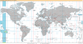
UTC−10:00 is an identifier for a time offset from UTC of −10:00. This time is used in Hawaii, Alaska, French Polynesia, and the Cook Islands.

Pago Pago International Airport, also known as Tafuna Airport, is a public airport located 7 miles (11.3 km) southwest of the central business district of Pago Pago, in the village and plains of Tafuna on the island of Tutuila in American Samoa, an unincorporated territory of the United States.
The Wake Island Time Zone observes standard time by adding twelve hours to Coordinated Universal Time (UTC+12:00). The clock time in this zone is based on the mean solar time of the 180th degree meridian east of the Greenwich Observatory.

The Chamorro Time Zone, formerly the Guam Time Zone, is a United States time zone which observes standard time ten hours ahead of Coordinated Universal Time (UTC+10:00). The clock time in this zone is based on the mean solar time of the 150th meridian east of the Greenwich Observatory.

Daylight saving time in the United States is the practice of setting the clock forward by one hour when there is longer daylight during the day, so that evenings have more daylight and mornings have less. Most areas of the United States observe daylight saving time (DST), the exceptions being Arizona, Hawaii, and the overseas territories of American Samoa, Guam, the Northern Mariana Islands, Puerto Rico, and the United States Virgin Islands. The Uniform Time Act of 1966 established the system of uniform daylight saving time throughout the US.

American Samoa is an unincorporated territory of the United States located in the South Pacific Ocean, southeast of the independent state of Samoa. Its location is centered on 14.3°S 170.7°W. It is east of the International Date Line, while Samoa is west of the Line. The total land area is 199 square kilometers (76.8 sq mi), slightly more than Washington, D.C. American Samoa is the southernmost territory of the United States and one of two U.S. territories south of the Equator, along with the uninhabited Jarvis Island. Tuna products are the main exports, and the main trading partner is the rest of the United States.
Alofau is a village on the southeast coast of Tutuila Island, American Samoa. It is located at the eastern end of Faga'itua Bay, six miles east of Pago Pago, between Pagai and Amouli. It is home to Alofau Village Marine Protected Area. It is an agrarian and traditional village. It is also a poor village with residents with low literacy and high unemployment rates. As of the U.S. Census 2000, the per capita income was $4,357 and 67 percent of children were below the poverty line. 15.6 percent of residents were receiving public assistance. It is lauded as a kava place in the Manu'a Songs. Alofau is located in Sa'Ole County.
Fagaʻalu is a village in central Tutuila Island, American Samoa. It is also known as Fagaʻalo. It is located on the eastern shore of Pago Pago Harbor, to the south of Pago Pago. American Samoa's lone hospital, Lyndon B. Johnson Tropical Medical Center, is located in Fagaʻalu. The village is centered around Fagaalu Stream.

Severe Tropical Cyclone Val was considered to be the worst tropical cyclone to affect the Samoan Islands since the 1889 Apia cyclone.
Parts of Australia, New Zealand and Fiji are areas of Oceania that currently observe daylight saving time (DST).
Alaska is officially covered by two time zones, as described below: