Administrative districts
The regency is divided administratively into nine districts (kecamatan), tabulated below with their areas and their populations at the 2010 Census [2] and the 2020 Census, [3] together with the official estimates as of mid-2023. [1] The table also includes the locations of the district administrative centers, the number of administrative villages in each district (128 rural desa and 6 urban kelurahan), and its postcode.
Kode
Wilayah | Name of
District
(kecamatan) | Area
in
km2 | Pop'n
Census
2010 | Pop'n
Census
2020 | Pop'n
Estimate
mid 2023 | Admin
centre | No.
of
villages | Post
code |
|---|
| 12.17.06 | Sianjur Mula Mula (a) | 140.24 | 9,138 | 10,003 | 10,285 | Ginolat | 12 | 22396 |
| 12.17.05 | Harian | 560.45 | 7,860 | 9,397 | 9,682 | Harian Boho | 13 | 22391 |
| 12.17.09 | Sitio-tio | 50.76 | 7,124 | 8,172 | 8,378 | Sabulan | 8 | 22397 |
| 12.17.02 | Onan Runggu | 60.89 | 10,329 | 11,122 | 11,415 | Onan Runggu | 12 | 22398 |
| 12.17.03 | Nainggolan | 87.86 | 11,849 | 12,871 | 13,293 | Nainggolan | 15 (b) | 22394 |
| 12.17.04 | Palipi | 129.55 | 16,087 | 18,209 | 18,849 | Mogang | 17 | 22393 |
| 12.17.07 | Ronggur Nihuta | 94.87 | 8,356 | 9,692 | 9,960 | Ronggur Nihuta | 8 | 22392 |
| 12.17.08 | Pangururan | 121.45 | 29,412 | 34,209 | 35,692 | Pasar Pangururan | 28 (c) | 22390 |
| 12.17.01 | Simanindo (d) | 198.20 | 19,498 | 22,766 | 23,779 | Ambarita | 21 (e) | 22395 |
| Totals | 1,444.25 | 119,653 | 136,441 | 141,333 | Pangururan | 134 | |
Notes: (a) includes the small island of Tulas (Pulau Tulas) in Lake Toba. (b) including the 2 kelurahan of Parhusip III and Siruma Hombar. (c) including the 3 kelurahan of Pasar Pangururan, Pintu Sona and Siogung Ogung. (d) includes the small islands of Pulau Tolping, Pulau Malau Satu, and Pulau Malau Dua in Lake Toba. (e) including the kelurahan of Tuktuk Siadong.
Six of the nine districts ( kecamatan ) within the regency are on the island of Samosir (which lies within Lake Toba), while the others lie on the 'mainland' of Sumatra.
- Samosir Island districts
- Onan Runggu
- Palipi
- Pangururan
- Ronggur Nihuta
- Simanindo
- Nainggolan
- Mainland districts
- Sitio-tio
- Harian
- Sianjur Mula Mula
However, a small part of Pangururan District (the two villages of Desa Tanjung Bunga and kelurahan Siogung Ogung, with a combined area of 10.50 km2 and a population of 3,222 at the 2020 Census [3] ) lies on the 'mainland', cut off from the rest of the district by the canal.

Bengkalis Regency is a regency of Indonesia in Riau Province. The regency was originally established in 1956 and then included most of the northern part of the province, but on 4 October 1999 it was divided up, with most of the territory being split off to form the new Rokan Hilir Regency, Siak Regency and the city of Dumai. On 19 December 2008 a further five districts were removed to create the new Meranti Islands Regency, leaving eight districts in the Bengkalis Regency. These eight districts has increased since 2010 to eleven by the splitting of existing districts on the Sumatran mainland.
Sikka is a regency within East Nusa Tenggara province, Indonesia, on the island of Flores. It is bordered to the west by Ende Regency and to the east by East Flores Regency. It covers an area of 1,675.36 km2 and had a population of 300,301 at the 2010 census and 321,953 at the 2020 Census; the official estimate as at mid 2023 was 335,360 - comprising 163,060 males and 172,300 females). The capital is the town of Maumere, which comprises the districts of Alok Barat, Alok and Alok Timur.

Karo Regency is a landlocked regency of North Sumatra Province of Indonesia, situated in the Barisan Mountains. The regency, which was established on 7 November 1956, covers an area of 2,127.25 square kilometres (821.34 sq mi) and according to the 2010 census it had a population of 350,479, increasing to 404,998 at the 2020 Census; the official estimate as at mid-2023 was 420,799, comprising 208,600 males and 212,200 females. 60.99% of the regency is forested. Its regency seat is the town of Kabanjahe. The Batak Karo language is spoken in the regency, as well as the Indonesian language. It borders Southeast Aceh Regency in Aceh to the west, Deli Serdang Regency and Langkat Regency to the north, Dairi Regency and Toba Samosir Regency to the south, and Deli Serdang Regency and Simalungun Regency to the east.

Pelalawan is a regency (kabupaten) of Riau Province, Indonesia. It is located on the island of Sumatra. The regency was created on 4 October 1999 as a result of the division of Kampar Regency, of which it was previously the eastern 43%. It now has an area of 13,408.72 km2 and had a population of 301,829 at the 2010 Census and 390,046 at the 2020 Census; the official estimate as at mid 2022 was 410,988. The administrative centre is in the town of Pangkalan Kerinci.

North Bengkulu is a regency of Bengkulu Province, Indonesia, on the island of Sumatra. It originally covered much of the northern part of Bengkulu Province, but on 25 February 2003 the most northwesterly districts were split off to form a separate Mukomuko Regency, and on 24 June 2008 the most southeastern districts were likewise split off to create a new Central Bengkulu Regency. The residual regency now covers an area of 4,424.59 km2, and it had a population of 257,675 at the 2010 Census and 296,523 at the 2020 Census; the official estimate as at mid 2022 was 302,833. The administrative centre is at the town of Arga Makmur.
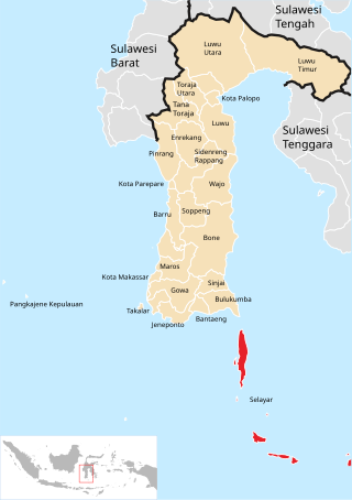
The Selayar Islands Regency is a regency of Indonesia in South Sulawesi province that covers the Selayar Islands, which lie southeast of the southern peninsula of Sulawesi. The archipelago consists of the group's main island, which is surrounded by 41 smaller islands around its coast; further to the southeast lies a widespread group of islands, including the smaller but still substantial islands of Pasimassunggu, Pasimarannu and Pasilambena in the far south, and the huge atoll of Takabonerate. The regency covers an area of 1,357.03 km2, and had a population of 103,596 at the 2000 Census, 122,055 at the Census of 2010 and 137,071 at that of 2020. The official estimate for mid 2023 was 142,100. The administrative centre is the town of Benteng on Selayar Island. The Selayar Straits separate the regency from Sulawesi island.

Humbang Hasundutan Regency is a landlocked regency in North Sumatra province of Indonesia. In the east of the regency, Baktiraja District stretches along a short part of the southern shore of Lake Toba in North Sumatra. The regency covers an area of 2,502.71 km2, and it had a population of 171,650 at the 2010 census and 197,751 at the 2020 census; the official estimate as at mid 2023 was 204,700. Its seat is the town of Dolok Sanggul. To the north is Samosir Regency and Pakpak Bharat Regency, to the east is North Tapanuli Regency, and to the west and south is Central Tapanuli Regency, and beyond the latter the Indian Ocean.

Labuhanbatu Regency, alternatively written in space as Labuhan Batu Regency, is a regency of North Sumatra Province in Indonesia. Its administrative seat is Rantau Prapat. An original regency of the province, it had an area of 9,703 km2 as at early 2008, prior to the separation out of its southern and its north-western districts respectively to create the new South Labuhanbatu and North Labuhanbatu Regencies on 21 July 2008.

Langkat Regency is the northernmost regency of North Sumatra Province in Indonesia. Its administrative centre is the town of Stabat. It has a land area of 6,263.29 km2 and its population was 967,535 at the 2010 Census and 1,030,202 at the 2020 Census; the official estimate as at mid 2023 was 1,066,711 - comprising 538,822 males and 527,889 females.
Pangururan is a town and a district of the same name in North Sumatra province of Indonesia and it is the seat (capital) of Samosir Regency, and the largest town on Samosir Island. The population of the district at the 2020 Census was 34,209. The district lies mainly on Samosir Island, but two villages lie on the 'mainland' of Sumatra.

Simalungun Regency is a regency in North Sumatra Province of Indonesia. Its seat was formerly at Pematangsiantar, but this city was under Law No.15 of 10 March 1986 was separated from the Regency and made into an independent city (kota), although it remains geographically surrounded by the regency, whose new administrative seat is at Raya, while the regency's two most populous districts are Bandar and Siantar. The regency now covers an area of 4,372.5 square kilometres, and at the 2010 census it had a population of 817,720; at the 2020 Census this had risen to 990,246, of whom 497,314 were males and 492,932 were females; the official estimate as at mid 2023 was 1,035,920 - comprising 521,262 males and 514,658 females.

North Tapanuli Regency is a landlocked regency in North Sumatra province, Sumatra, Indonesia. Its capital is Tarutung. The regency covers an area of 3,793.71 square kilometres and it had a population of 278,897 at the 2010 Census and 312,758 at the 2020 Census; the official estimate as of mid-2023 was 323,102.
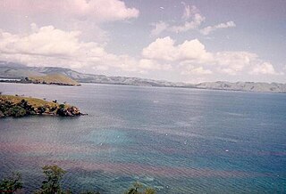
Toba Regency is a landlocked regency in North Sumatra. Its seat is Balige. The regency covers an area of 2,021.8 square kilometres; it had a population of 173,129 at the 2010 census and 206,199 at the 2020 Census; the official estimate as at mid 2023 was 213,850. Although landlocked, the regency includes the eastern shore of the vast inland Lake Toba.

Sumbawa Regency is a Regency (Kabupaten) of the Indonesian Province of West Nusa Tenggara. It is located on the island of Sumbawa and covers an area of 6,643.99 km2, following the separation on 18 December 2003 of what were until then its westernmost five districts to form the newly-created West Sumbawa Regency. It includes the substantial island of Moyo, lying off the north coast of Sumbawa. The population of the Regency at the 2010 Census was 415,789, which rose at the 2020 Census to 509,753; the official estimate as at mid 2023 was 529,487. The capital is the town of Sumbawa Besar on the north coast of Sumbawa Island.

West Sumbawa Regency is a Regency (Kabupaten) of the Indonesian Province of West Nusa Tenggara. It is located on the island of Sumbawa and has an area of 1,743.58 km2. The regency was created on 18 December 2003 from what were at that time the westernmost five districts (kecamatan) of Sumbawa Regency. The population at the 2010 Census was 114,754, and at the 2020 Census was 145,798; the official estimate as at mid 2023 was 152,950 comprising 77,030 males and 75,920 females. The capital is the town of Taliwang.

Meranti Islands is an archipelago forming a regency (kabupaten) of Riau Province and lies off the eastern coast of the island of Sumatra, Indonesia. It was created on 19 December 2008 by the separating of this archipelago from the mainland regency of Bengkalis. The regency comprises the islands of Tebing Tinggi, Rangsang, Padang, and Merbau, together with minor offshore islands, but does not include Bengkalis Island which is geographically part of the archipelago but remains within Bengkalis Regency. The principal town is Selat Panjang on Tebing Tinggi Island. The regency covers an area of 3,623.93 km2 and had a population of 176,290 at the 2010 Census and 206,116 at the 2020 Census; the official estimate as of mid-2022 was 213,532.

Merangin is a regency (kabupaten) of Jambi Province on the island of Sumatra, Indonesia. It was created on 4 October 1999 by the division of the former Sarolangun Bangko Regency into a new Sarolangun Regency and this Merangin Regency. The regency covers an area of 7,668.61 km2, and had a population of 333,206 at the 2010 census and 354,052 at the 2020 census; the official estimate as at mid 2022 was 357,577, comprising 181,850 males and 175,727 females. The administrative capital is the town of Bangko.

Tanggamus Regency is a regency (kabupaten) of Lampung Province, Sumatra, Indonesia. It has an area of 4,654.96 km2 which consists of a land area of 2,855.46 km2 and a sea area of 1,799.5 km2. It had a population of 534,595 at the 2010 Census and 640,275 at the 2020 Census; the official estimate as at mid 2023 was 662,542. The regency seat is the town of Kota Agung Pusat. The regency was created on 21 March 1997 from what were previously the western districts of South Lampung Regency, but districts in its eastern part split away on 29 October 2008 to form the new Pringsewu Regency. It lies in the southwest of the province, and surrounds Semangka Bay on its west, north and east coasts.

The Pangkajene and Islands Regency, is a regency of South Sulawesi province of Indonesia. The regency lies primarily on the mainland of Sulawesi's southern peninsula, but also includes the Spermonde Islands off the west coast of that peninsula, as well as other small islands further west and southwest. The principal town lies at Pangkajene on Sulawesi, but there are a series of further small towns like Lejang, Labakkang, Bonto-Bonto and Segeri proceeding northwards from Pangkajene along the Trans-Sulawesi Highway. The total land area is 1,112.29 km2, and the population was 305,737 at the 2010 Census and 345,775 at the 2020 Census; the official population estimate as of mid-2023 was 357,846.

Sinjai Regency is a regency of the South Sulawesi province of Indonesia. The regency, which is separated from the Bone Regency to its north by the River Tangka, covers an area of 819.96 km2. It had a population of 228,936 at the 2010 census and 259,478 at the 2020 census. The official estimate of population as of mid-2024 was 273,559. It includes the Nine Islands in the Gulf of Bone off the east coast of the southern peninsula of Sulawesi; this archipelago forms an administrative district within the regency. The regency's principal town lies at Sinjai, a port situated on the east coast of that peninsula.


