The cave is a 30-foot (9.1m) deep hole in the sandstone, discovered by 18-year-old Frank Samuel while trapping raccoons in 1878. He squeezed into a hole that an animal had dug in a bank and emerged into a dark cavity. On the walls, the young coon-hunter found simple images left by people before him. That winter some local boys built fires inside their secret cave and carved their own names on the walls.[3]
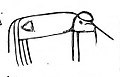
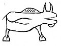
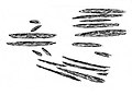
Brown's tracing of one of the carvings, as it appeared in 1879.
The following summer the Rev. Edward Brown visited Samuels' cave. He traced the carvings and persuaded Frank's father to open the mouth of the cave and protect the interior. Brown reported the finding to the State Geologist and the State Historical Society, and they sent antiquarian archaeologist John Rice to direct the excavation of the floor. They uncovered four layers of ashes separated by layers of clean sand ten to fourteen inches thick. The second layer contained sherds of pottery made from clay and ground shells. The third layer contained more elaborate pottery, bivalve shells, and a bone tool. Brown and Rice interpreted the layers as four occupations of the cave with long intervals of vacancy between. When the rock shelter was occupied, its mouth had been fifteen feet wide, but a landslide had sealed it until the animal burrowed through. Based on trees growing on the landslide, Brown and Rice estimated the landslide had occurred at least 150 years before.[3][4] Modern archeologists recognize the shell-tempered pottery that Brown described as a hallmark of the Oneota people, so at least some of the artwork was probably produced by them, which places it from 1300 to 1625 A.D.[5][6][7]
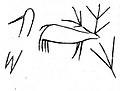
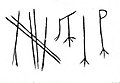
Some images on the walls were carved and some were painted. There were animals which Brown interpreted as bisons, lynx, rabbit, otter, badger, elk and heron. One panel showed a hunter and an elk. Another showed a hunter pointing a bow and arrow at a deer, with a child behind him. Another showed a human figure with a head-dress, which Brown interpreted as a chief. Other designs were indecipherable.[3]
In 1984 archaeologists from the Mississippi Valley Archaeological Center at the University of Wisconsin-La Crosse visited Samuels' Cave and noticed a panel of charcoal drawings on the back wall which had not been recorded before. (Photos of some of these drawings are online at MVAC's Rock Art website, linked among the notes below.)[5][6][7]
Many of the images in the cave were pretty intact when Frank Samuel found them in 1878, since they had been protected by the landslide for many years.[4] But once the mouth of the cave was reopened, moisture and temperature changes resumed working away at the sandstone. Over the years many people visited the cave, some carving their own marks on the walls. After all this, many of the prehistoric images have been badly damaged,[2] so the cave is no longer open to the public.
More of Brown's tracings from the cave, as the images appeared in 1879:
1 2 Boszhardt, Robert F. (2003). Deep Cave Rock Art in the Upper Mississippi Valley. St. Paul, Minn.: Prairie Smoke Press. pp.13, 24. ISBN0970448236.
1 2 Johannes H.N. Loubser; Robert F. Boszhardt (2004). Diaz-Granados, Carol; Duncan, James R. (eds.). Recordation, Conservation and Management of Rock Imagery at Samuel's Cave, Wisconsin, in The Rock-Art of Eastern North America. Tuscaloosa, Ala.: University of Alabama Press. pp.219–238. ISBN0817350969.
1 2 Boszhardt, Robert F.; Schrab, Geri (2016). Hidden Thunder - Rock Art in the Upper Midwest. Madison, Wisc.: Wisconsin Historical Society. pp.7–25. ISBN0870207679.
In the history of art, prehistoric art is all art produced in preliterate, prehistorical cultures beginning somewhere in very late geological history, and generally continuing until that culture either develops writing or other methods of record-keeping, or makes significant contact with another culture that has, and that makes some record of major historical events. At this point ancient art begins, for the older literate cultures. The end-date for what is covered by the term thus varies greatly between different parts of the world.
Ceramics of Indigenous peoples of the Americas is an art form with at least a 7500-year history in the Americas. Pottery is fired ceramics with clay as a component. Ceramics are used for utilitarian cooking vessels, serving and storage vessels, pipes, funerary urns, censers, musical instruments, ceremonial items, masks, toys, sculptures, and a myriad of other art forms.
The Driftless Area, also known as Bluff Country and the Paleozoic Plateau, is a topographical and cultural region in the Midwestern United States that comprises southwestern Wisconsin, southeastern Minnesota, northeastern Iowa, and the extreme northwestern corner of Illinois. The Driftless Area is a USDA Level III Ecoregion: Ecoregion 52. The Driftless Area takes up a large portion of the Upper Midwest forest–savanna transition. The Blufflands refers to the eastern section of the Driftless area in Minnesota, due to the steep bluffs and cliffs around the river valleys. The western half is known as the Rochester Plateau, which is flatter than the Blufflands. The Coulee Region refers to the southwestern part of the Driftless Area in Wisconsin. It is named for its numerous ravines.
The Tsodilo Hills are a UNESCO World Heritage Site (WHS), consisting of rock art, rock shelters, depressions, and caves in southern Africa. It gained its WHS listing in 2001 because of its unique religious and spiritual significance to local peoples, as well as its unique record of human settlement over many millennia. UNESCO estimates there are over 4500 rock paintings at the site. The site consists of a few main hills known as the Child Hill, Female Hill, and Male Hill.
Gatecliff Rockshelter (26NY301) is a major archaeological site in the Great Basin area of the western United States that provides remarkable stratigraphy; it has been called the "deepest archaeological rock shelter in the Americas". Located in Mill Canyon of the Toquima Range in the Monitor Valley of central Nevada, Gatecliff Rockshelter has an elevation of 7,750 feet (2,360 m). David Hurst Thomas discovered Gatecliff Rockshelter in 1970 and began excavations in 1971. Full scale excavations occurred at Gatecliff Rockshelter for about seven field seasons in which nearly 33 feet (10 m) of sediments were exposed for a well-defined stratigraphic sequence. The well-preserved artifacts and undisturbed sediments at Gatecliff Rockshelter provides data and information have been applied to a range of research topics. Based on the analysis of the artifacts at Gatecliff Rockshelter, it can be determined that it was most likely a short-term field camp throughout prehistory. The latest evidence for human usage at Gatecliff occurs between ca. 5500 B.P. to 1250 B.P.
Silver Mound is a sandstone hill in Wisconsin where American Indians quarried quartzite for stone tools. Tools made from Silver Mound's quartzite have been found as far away as Kentucky. The oldest have been dated to around 11,000 years ago, so they provide clues about the first people in Wisconsin. Silver Mound Archeological District was declared a National Historic Landmark in 2006.
The Prehistory of West Virginia spans ancient times until the arrival of Europeans in the early 17th century. Hunters ventured into West Virginia's mountain valleys and made temporary camp villages since the Archaic period in the Americas. Many ancient human-made earthen mounds from various mound builder cultures survive, especially in the areas of Moundsville, South Charleston, and Romney. The artifacts uncovered in these areas give evidence of a village society with a tribal trade system culture that included limited cold worked copper. As of 2009, over 12,500 archaeological sites have been documented in West Virginia.
The Upper Mississippian cultures were located in the Upper Mississippi basin and Great Lakes region of the American Midwest. They were in existence from approximately A.D. 1000 until the Protohistoric and early Historic periods.
Mummy Cave is a rock shelter and archeological site in Park County, Wyoming, United States, near the eastern entrance to Yellowstone National Park. The site is adjacent to the concurrent U.S. Routes 14/16/20, on the left bank of the North Fork of the Shoshone River at an altitude of 6,310 feet (1,920 m) in Shoshone National Forest.
Mississippian culture pottery is the ceramic tradition of the Mississippian culture found as artifacts in archaeological sites in the American Midwest and Southeast. It is often characterized by the adoption and use of riverine shell-tempering agents in the clay paste. Shell tempering is one of the hallmarks of Mississippian cultural practices. Analysis of local differences in materials, techniques, forms, and designs is a primary means for archaeologists to learn about the lifeways, religious practices, trade, and interaction among Mississippian peoples. The value of this pottery on the illegal antiquities market has led to extensive looting of sites.
The Trinchera Cave Archeological District (5LA9555) is an archaeological site in Las Animas County, Colorado with artifacts primarily dating from 1000 BC to AD 1749, although there were some Archaic period artifacts found. The site was added to the National Register of Historic Places in 2001 and is located on State Trust Lands.
Cathole Cave, Cat Hole Cave or Cathole Rock Cave, is a cave near Parc Cwm long cairn at Parc le Breos, on the Gower Peninsula, Wales. It is a steep limestone outcrop, about 200 yards (180 m) north of the cromlech along the Parc le Breos Cwm valley and near the top of the gorge, about 50 feet (15 m) from the valley floor. The cave is a deep triangular fissure penetrating the hillside and narrowing towards the top. It has two entrances, with a natural platform outside the larger of the two. It is about seven 1⁄2 miles (12 km) west south–west of Swansea, Wales, in what is now known as Coed y Parc Cwm at Parc le Breos, on the Gower Peninsula.
Melkhoutboom Cave is an archaeological site dating to the Later Stone Age, located in the Zuurberg Mountains, Cape Folded Mountain Belt, in the Addo Elephant National Park, Sarah Baartman District Municipality in the Eastern Cape Province of South Africa.
Zengpiyan is a Neolithic cave site in southern China. It is located in the Guilin region on the south-western fringes of the Dushan Mountain in the autonomous region Guangxi and is considered to be one of the most important cave sites of the Neolithic in China as it is one of the many independent centers for the introduction of animal domestication and pottery.
Tainter Cave, also known as Tombstone Cave, is a dry sandstone cave in Crawford County, Wisconsin, in which prehistoric Native Americans carved petroglyphs and drew pictographs, including birds, men, deer, and abstract designs. With over 100 pictographs, the cave holds more than any other known site in Wisconsin. It is also notable as the first archaeological site recorded in the dark zone of a cave in the Upper Midwest.
Bambata Cave is one of the Southern Africa prehistoric sites situated in Motobo National Park along with Inanke, Nswatugi, Pomengwe and Silozwane caves in Zimbabwe.
A temper is a non-plastic material added to clay to prevent shrinkage and cracking during drying and firing of vessels made from the clay. Tempers may include:
The Fifield Site (Pr-55) is located on Damon Run Creek in Porter County, north-western Indiana. It is classified as a late prehistoric, single-component Upper Mississippian Fisher village.
The Midway Site (47LC19) is a prehistoric Upper Mississippian Oneota site in La Crosse County, Wisconsin. It is located about 10 miles north of LaCrosse near the juncture of the Black and Mississippi Rivers.
The Taino were the indigenous people of the Caribbean and the principal inhabitants of Cuba, the Dominican Republic, Haiti, Jamaica, and Puerto Rico. Caribbean archaeologists have theorized that by the mid 16th century the native people of the Caribbean were extinct. However, the story of Taino extinction may not be the case according to recent research and archaeological findings.
This page is based on this Wikipedia article Text is available under the CC BY-SA 4.0 license; additional terms may apply. Images, videos and audio are available under their respective licenses.