La Crosse County, Wisconsin

Last updated

La Crosse County
La Crosse County Courthouse.jpg
La Crosse County Courthouse
La Crosse County, Wisconsin seal.png
Map of Wisconsin highlighting La Crosse County.svg
Location within the U.S. state of Wisconsin
Wisconsin in United States.svg
Wisconsin's location within the U.S.
Coordinates: 43°55′N91°07′W / 43.91°N 91.11°W / 43.91; -91.11
CountryFlag of the United States.svg United States
StateFlag of Wisconsin.svg  Wisconsin
Founded1851
Seat La Crosse
Largest cityLa Crosse
Area
  Total480 sq mi (1,200 km2)
  Land452 sq mi (1,170 km2)
  Water28 sq mi (70 km2)  5.9%
Population
 (2020)
  Total120,784
  Estimate 
(2023)
120,486 Decrease2.svg
  Density250/sq mi (97/km2)
Time zone UTC−6 (Central)
  Summer (DST) UTC−5 (CDT)
Congressional district 3rd
Website www.lacrossecounty.org

La Crosse County is a county located in the U.S. state of Wisconsin. At the 2020 census, the population was 120,784. [1] Its county seat is La Crosse. [2] La Crosse County is included in the La Crosse-Onalaska, WI-MN Metropolitan Statistical Area with a population of 139,627 and is the most populous county on Wisconsin's western border.

Contents

Geography

According to the U.S. Census Bureau, the county has a total area of 480 square miles (1,200 km2), of which 452 square miles (1,170 km2) is land and 28 square miles (73 km2) (5.9%) is water. [3]

Major highways

Railroads

Buses

Airport

Adjacent counties

Climate

La Crosse County's location in the United States' upper midwest gives the area a temperate, continental climate. [4] The warmest month of the year is July, when the average high temperature is 85.4 °F (29.7 °C), with overnight low temperatures averaging 27.4 °F (−2.6 °C). January is the coldest month, with high temperatures averaging 25.9 °F (−3.4 °C), with the overnight low temperatures around 10.5 °F (−11.9 °C). [5]

Climate data for La Crosse Regional Airport, Wisconsin (1981–2010 normals, [6] extremes 1872–present)
MonthJanFebMarAprMayJunJulAugSepOctNovDecYear
Record high °F (°C)57
(14)
65
(18)
84
(29)
93
(34)
107
(42)
102
(39)
108
(42)
105
(41)
101
(38)
93
(34)
80
(27)
67
(19)
108
(42)
Mean maximum °F (°C)45.4
(7.4)
50.5
(10.3)
69.0
(20.6)
82.2
(27.9)
87.8
(31.0)
93.6
(34.2)
95.7
(35.4)
94.0
(34.4)
89.2
(31.8)
80.6
(27.0)
64.0
(17.8)
48.1
(8.9)
97.7
(36.5)
Mean daily maximum °F (°C)25.9
(−3.4)
31.4
(−0.3)
43.9
(6.6)
59.3
(15.2)
70.7
(21.5)
80.0
(26.7)
84.1
(28.9)
81.5
(27.5)
73.2
(22.9)
59.9
(15.5)
43.8
(6.6)
29.1
(−1.6)
57.0
(13.9)
Mean daily minimum °F (°C)8.9
(−12.8)
13.6
(−10.2)
25.2
(−3.8)
37.9
(3.3)
48.7
(9.3)
58.5
(14.7)
63.2
(17.3)
61.3
(16.3)
52.4
(11.3)
40.4
(4.7)
28.1
(−2.2)
14.2
(−9.9)
37.8
(3.2)
Mean minimum °F (°C)−13.8
(−25.4)
−10.4
(−23.6)
3.9
(−15.6)
21.7
(−5.7)
34.1
(1.2)
44.6
(7.0)
51.5
(10.8)
49.3
(9.6)
36.5
(2.5)
25.4
(−3.7)
12.0
(−11.1)
−8.7
(−22.6)
−18.4
(−28.0)
Record low °F (°C)−43
(−42)
−36
(−38)
−28
(−33)
7
(−14)
26
(−3)
33
(1)
44
(7)
35
(2)
24
(−4)
6
(−14)
−21
(−29)
−37
(−38)
−43
(−42)
Average precipitation inches (mm)1.12
(28)
1.05
(27)
2.04
(52)
3.34
(85)
3.52
(89)
4.34
(110)
4.26
(108)
4.29
(109)
3.56
(90)
2.17
(55)
2.01
(51)
1.36
(35)
33.06
(840)
Average snowfall inches (cm)10.7
(27)
8.2
(21)
7.1
(18)
1.7
(4.3)
0
(0)
0
(0)
0
(0)
0
(0)
0
(0)
0.2
(0.51)
4.1
(10)
11.3
(29)
43.3
(110)
Average precipitation days (≥ 0.01 in)9.18.09.811.211.911.510.49.89.69.39.09.2118.8
Average snowy days (≥ 0.1 in)7.86.44.31.2000000.33.17.030.1
Source: NOAA [7] [8]

Demographics

Historical population
CensusPop.Note
1860 12,186
1870 20,29766.6%
1880 27,07333.4%
1890 38,80143.3%
1900 42,99710.8%
1910 43,9962.3%
1920 44,3550.8%
1930 54,45522.8%
1940 59,6539.5%
1950 67,58713.3%
1960 72,4657.2%
1970 80,46811.0%
1980 91,05613.2%
1990 97,9047.5%
2000 107,1209.4%
2010 114,6387.0%
2020 120,7845.4%
2023 (est.)120,486 [9] −0.2%
U.S. Decennial Census [10]
1790–1960 [11] 1900–1990 [12]
1990–2000 [13] 2010–2020 [14] [15]

As of the census of 2020, [16] the population was 120,784. The population density was 267.3 people per square mile (103.2 people/km2). There were 52,774 housing units at an average density of 116.8 units per square mile (45.1 units/km2). The racial makeup of the county was 88.0% White, 4.6% Asian, 1.7% Black or African American, 0.4% Native American, 0.9% from other races, and 4.4% from two or more races. Ethnically, the population was 2.5% Hispanic or Latino of any race.

2000 Census Age Pyramid for La Crosse County USA La Crosse County, Wisconsin age pyramid.svg
2000 Census Age Pyramid for La Crosse County

According to 2014–2018 ACS estimates, the median household income was $55,479 and the median family income was $67,388. Males had a median income of $48,675 and females $38,714. The per capita income was $26,065. About 9.1% of families and 10.9% of the population were below the poverty line, including 8.2% of those under age 18 and 7.3% of those age 65 or over. [17]

At the 2010 census, [18] there were 114,638 people, 46,137 households and 27,373 families residing in the county. The population density was 255 per square mile (98/km2). There were 46,137 housing units at an average density of 96 per square mile (37/km2). The racial make up was 92.1% White, 1.4% Black or African American, 0.4% Native American, 4.1% Asian, 0.00% Pacific Islander, 0.3% from other races, and 1.6% from two or more races. 0.92% of the population were Hispanic or Latino of any race. 38.9% were of German, 20.3% Norwegian and 7.9% Irish ancestry. In 2017, there were 1,188 births, giving a general fertility rate of 47.9 births per 1000 women aged 15–44, the fifth lowest rate out of all 72 Wisconsin counties. [19]

Government

Politics

La Crosse County has voted for the Democratic nominee in every presidential election since 1988. [24] The Milwaukee Journal Sentinel ranked La Crosse County as one of Wisconsin's most Democratic counties. [25] As a result of the 2020 presidential election, La Crosse County continued its Democratic trend by about 4% with a 13% lead over Republicans. [26] In the 2022 United States elections Democrats won every contested race in La Crosse County and flipped the Sheriff's race for the first time in recent history. [27]

La Crosse County is within the Wisconsin State Senate district 32, represented by Brad Pfaff (D). It also contains Wisconsin State Assembly districts 95 Jill Billings (D) and 94 Steve Doyle (D). Democrats also hold a majority of seats on the La Crosse County Board of Supervisors.

United States presidential election results for La Crosse County, Wisconsin [28]
Year Republican Democratic Third party
No.%No.%No.%
2020 28,68442.25%37,84655.75%1,3541.99%
2016 26,37841.43%32,40650.89%4,8907.68%
2012 25,75140.58%36,69357.82%1,0181.60%
2008 23,70137.49%38,52460.94%9931.57%
2004 28,28945.53%33,17053.38%6771.09%
2000 24,32743.79%28,45551.22%2,7775.00%
1996 16,48235.83%23,64751.41%5,87212.76%
1992 18,89136.14%22,83843.69%10,54420.17%
1988 21,54848.90%22,20450.39%3140.71%
1984 25,72158.77%17,78740.64%2610.60%
1980 23,42751.73%17,30438.21%4,55410.06%
1976 24,18858.06%16,67440.02%7971.91%
1972 21,99263.29%12,15234.97%6021.73%
1968 17,43355.76%11,57037.00%2,2647.24%
1964 13,13544.07%16,62555.78%430.14%
1960 18,31956.08%14,31043.81%360.11%
1956 18,26461.66%11,25838.01%1000.34%
1952 19,27161.90%11,80837.93%530.17%
1948 10,52545.25%12,34553.07%3901.68%
1944 12,78450.93%12,24748.79%720.29%
1940 13,71150.92%13,07948.58%1340.50%
1936 7,55833.09%14,45563.29%8273.62%
1932 7,68636.94%12,91962.10%2000.96%
1928 11,32155.78%8,87743.74%970.48%
1924 5,73332.49%1,2527.09%10,66260.42%
1920 10,06773.96%2,58819.01%9567.02%
1916 3,59744.37%4,12350.86%3864.76%
1912 2,27228.28%4,26353.07%1,49818.65%
1908 4,38250.15%4,05446.40%3013.45%
1904 5,50661.76%3,08934.65%3203.59%
1900 5,32458.24%3,60939.48%2082.28%
1896 6,29764.58%3,05831.36%3964.06%
1892 3,69342.88%3,81044.24%1,11012.89%

Communities

Cities

Villages

Towns

Census-designated places

Unincorporated communities

See also

Related Research Articles

<span class="mw-page-title-main">Washington County, Wisconsin</span> County in Wisconsin, United States

Washington County is a county in the U.S. state of Wisconsin. As of the 2020 census, the population was 136,761. Its county seat is West Bend. The county was created from Wisconsin Territory in 1836 and organized in 1845. It was named after President George Washington.

<span class="mw-page-title-main">Washburn County, Wisconsin</span> County in Wisconsin, United States

Washburn County is a county in the U.S. state of Wisconsin. It is named after Governor Cadwallader C. Washburn. As of the 2020 census, the population was 16,623. Its county seat is Shell Lake. The county was created in 1883.

<span class="mw-page-title-main">Walworth County, Wisconsin</span> County in Wisconsin, United States

Walworth County is a county located in the U.S. state of Wisconsin. As of the 2020 census, the population was 106,478. Its county seat is Elkhorn. The county was created in 1836 from Wisconsin Territory and organized in 1839. It is named for Reuben H. Walworth. Walworth County comprises the Whitewater-Elkhorn, WI Micropolitan Statistical Area and is included in the Milwaukee-Racine-Waukesha, WI Combined Statistical Area. Lake Geneva, the University of Wisconsin-Whitewater, and Alpine Valley Resort, and Music Theatre are located in Walworth County.

<span class="mw-page-title-main">Trempealeau County, Wisconsin</span> County in Wisconsin, United States

Trempealeau County is a county in the U.S. state of Wisconsin. As of the 2020 census, the population was 30,760. Its county seat is Whitehall.

<span class="mw-page-title-main">Rock County, Wisconsin</span> County in Wisconsin, United States

Rock County is a county in the U.S. state of Wisconsin. As of the 2020 census, the population was 163,687. Its county seat is Janesville. Rock County comprises the Janesville-Beloit, WI Metropolitan Statistical Area and is included in the Madison-Janesville-Beloit, WI Combined Statistical Area.

<span class="mw-page-title-main">Monroe County, Wisconsin</span> County in Wisconsin, United States

Monroe County is a county in the U.S. state of Wisconsin. As of the 2020 census, the population was 46,274. Its county seat is Sparta.

<span class="mw-page-title-main">Marquette County, Wisconsin</span> County in Wisconsin, United States

Marquette County is a county located in the U.S. state of Wisconsin. As of the 2020 census, the population was 15,592. Its county seat is Montello. The county was created in 1836 from the Wisconsin Territory and organized in 1848.

<span class="mw-page-title-main">Lafayette County, Wisconsin</span> County in Wisconsin, United States

Lafayette County, sometimes spelled La Fayette County, is a county located in the U.S. state of Wisconsin. It was part of the Wisconsin Territory at the time of its founding. As of the 2020 census, the population was 16,611. Its county seat is Darlington. The county was named in honor of the Marquis de Lafayette, the French general who rendered assistance to the Continental Army in the American Revolutionary War. The courthouse scenes from the 2009 film Public Enemies were filmed at the Lafayette County Courthouse in Darlington.

<span class="mw-page-title-main">Green Lake County, Wisconsin</span> County in Wisconsin, United States

Green Lake County is a county located in the U.S. state of Wisconsin. As of the 2020 census, the population was 19,018. Its county seat is Green Lake. In 2020, the center of population of Wisconsin was located in Green Lake County, near the city of Markesan.

<span class="mw-page-title-main">Eau Claire County, Wisconsin</span> County in Wisconsin, United States

Eau Claire County is a county located in the U.S. state of Wisconsin. As of the 2020 census, the population was 105,710. Its county seat is Eau Claire. The county took its name from the Eau Claire River.

<span class="mw-page-title-main">Columbia County, Wisconsin</span> County in Wisconsin, United States

Columbia County is a county located in the U.S. state of Wisconsin. As of the 2020 census, the population was 58,490. Its county seat and largest city is Portage. The county was created in 1846 as part of Wisconsin Territory.

<span class="mw-page-title-main">Barron County, Wisconsin</span> County in Wisconsin, United States

Barron County is a county located in the U.S. state of Wisconsin. As of the 2020 census, the population was 46,711. Its county seat is Barron. The county was created in 1859 and later organized in 1874.

<span class="mw-page-title-main">Houston County, Minnesota</span> County in Minnesota, United States

Houston County is a county in the U.S. state of Minnesota. At the 2020 census, the population was 18,843. Its county seat is Caledonia.

<span class="mw-page-title-main">Campbell, Wisconsin</span> Town in Wisconsin, United States

Campbell is a town in the middle of the Mississippi River in La Crosse County, Wisconsin, United States. It is part of the La Crosse, Wisconsin Metropolitan Statistical Area. The population was 4,284 as of the 2020 Census.

<span class="mw-page-title-main">West Salem, Wisconsin</span> Village in Wisconsin, United States

West Salem is a village in La Crosse County, Wisconsin, United States, along the La Crosse River. It is part of the La Crosse-Onalaska, WI-MN Metropolitan Statistical Area. The population was 5,277 as of the 2020 census.

<span class="mw-page-title-main">Galesville, Wisconsin</span> City in Wisconsin, United States

Galesville is a city in Trempealeau County, Wisconsin, United States. The population was 1,662 at the 2020 census. A dam on Beaver Creek is located at Galesville, forming Lake Marinuka north of the city. The mayor is Vince Howe.

<span class="mw-page-title-main">Onalaska (town), Wisconsin</span> Town in the United States

Onalaska is a town in La Crosse County, Wisconsin, United States. The population was 5,623 at the 2010 census. The City of Onalaska borders the town, as does the village of Holmen. The CDP of Brice Prairie is located in the western part of the Town of Onalaska. The unincorporated community of Midway is also located in the town. Onalaska (town), Wisconsin is part of the La Crosse, Wisconsin Metropolitan Statistical Area.

<span class="mw-page-title-main">Onalaska, Wisconsin</span> City in the United States

Onalaska is a city in La Crosse County, Wisconsin, United States. The population was 18,803 at the 2020 census. It borders the larger La Crosse, Wisconsin, and is a part of the La Crosse-Onalaska, WI-MN Metropolitan Area.

<span class="mw-page-title-main">Arcadia, Wisconsin</span> City in Wisconsin, United States

Arcadia is a city in Trempealeau County, Wisconsin, United States, along the Trempealeau River. The population was 3,737 at the 2020 census. Arcadia is a Latino-majority city and the largest city in Trempealeau county.

<span class="mw-page-title-main">La Crosse–Onalaska</span> Metropolitan Statistical Area in the United States

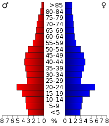
The La Crosse–Onalaska Metropolitan Statistical Area, as defined by the United States Census Bureau, is an area consisting of La Crosse County, Wisconsin and Houston County, Minnesota, anchored by the cities of La Crosse and Onalaska. The area is part of what is commonly referred to as the Coulee Region or 7 Rivers Region. As of the 2020 census, the MSA had a population of 139,627, and in 2022 estimates placed the total population at 139,094.

References

  1. "U.S. Census Bureau QuickFacts: La Crosse County, Wisconsin". www.census.gov. Retrieved August 27, 2021.
  2. "Find a County". National Association of Counties. Retrieved June 7, 2011.
  3. "2010 Census Gazetteer Files". United States Census Bureau. August 22, 2012. Retrieved August 5, 2015.
  4. "Wisconsin State Climatology Office". University of Wisconsin. 2023. Retrieved November 1, 2023.
  5. "La Crosse Climate Data". Wisconsin State Climatology Office. University of Wisconsin. 2023. Retrieved November 1, 2023.
  6. Mean monthly maxima and minima (i.e. the expected highest and lowest temperature readings at any point during the year or given month) calculated based on data at said location from 1981 to 2010.
  7. "NOWData – NOAA Online Weather Data". National Oceanic and Atmospheric Administration . Retrieved March 9, 2018.
  8. "Station Name: WI LA CROSSE MUNI AP". National Oceanic & Atmospheric Administration. Retrieved March 9, 2018.
  9. "Annual Estimates of the Resident Population for Counties: April 1, 2020 to July 1, 2023" . Retrieved May 2, 2024.
  10. "U.S. Decennial Census". United States Census Bureau. Retrieved August 5, 2015.
  11. "Historical Census Browser". University of Virginia Library. Retrieved August 5, 2015.
  12. Forstall, Richard L., ed. (March 27, 1995). "Population of Counties by Decennial Census: 1900 to 1990". United States Census Bureau. Retrieved August 5, 2015.
  13. "Census 2000 PHC-T-4. Ranking Tables for Counties: 1990 and 2000" (PDF). United States Census Bureau. April 2, 2001. Archived (PDF) from the original on October 9, 2022. Retrieved August 5, 2015.
  14. https://www.census.gov/quickfacts/fact/table/lacrossecountywisconsin,lacrossecitywisconsin,detroitcitymichigan,US/PST045219 [ dead link ]
  15. "State & County QuickFacts". United States Census Bureau. Archived from the original on June 6, 2011. Retrieved January 21, 2014.
  16. "2020 Decennial Census: La Crosse County, Wisconsin". data.census.gov. U.S. Census Bureau. Retrieved July 4, 2022.
  17. "La Crosse County, Wisconsin". data.census.gov. Retrieved July 24, 2020.
  18. "U.S. Census website". United States Census Bureau . Retrieved May 14, 2011.
  19. "Annual Wisconsin Birth and Infant Mortality Report, 2017 P-01161-19 (June 2019): Detailed Tables". Archived from the original on June 19, 2019. Retrieved June 19, 2019.
  20. Tribune, Olivia Herken La Crosse. "3 longtime supervisors named to lead La Crosse County Board". La Crosse Tribune. Retrieved July 1, 2020.
  21. "Treasurer".
  22. "LA CROSSE COUNTY BOARD OF SUPERVISORS. April 2010 — April 2012" (PDF). www.co.la-crosse.wi.us. June 6, 2010. Archived from the original (PDF) on July 19, 2011. Retrieved March 11, 2024.
  23. "La Crosse County Administrator".
  24. "Dave Leip's Atlas of U.S. Presidential Elections". uselectionatlas.org. Retrieved November 8, 2020.
  25. Gilbert, Craig (December 3, 2014). "The reddest and bluest places in Wisconsin". Jsonline.com. Retrieved March 14, 2022.
  26. VETTERKIND, RILEY. "Cities propelled Joe Biden to Wisconsin win as rural areas double down on Donald Trump". La Crosse Tribune. Retrieved November 8, 2020.
  27. Tribune, Chloe Hilles La Crosse. "Majority of voters in La Crosse County cast ballots for Democrats even with decrease in voter turnout". La Crosse Tribune. Retrieved January 3, 2023.
  28. Leip, David. "Dave Leip's Atlas of U.S. Presidential Elections". US Election Atlas. Retrieved August 14, 2018.

Further reading

43°55′N91°07′W / 43.91°N 91.11°W / 43.91; -91.11