
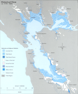
San Francisco Bay is a large tidal estuary in the U.S. state of California, and gives its name to the San Francisco Bay Area. It is dominated by the large cities of San Francisco, San Jose, and Oakland.

The Santa Clara Valley Transportation Authority, more commonly known simply as the Valley Transportation Authority (VTA), is a special district responsible for public transit services, congestion management, specific highway improvement projects, and countywide transportation planning for Santa Clara County, California. It serves San Jose, California and the surrounding Silicon Valley. It is one of the governing parties for the Caltrain commuter rail line that serves the county.

Crissy Field is a public recreation area on the northern shore of the San Francisco Peninsula in California, United States, located just east of the Golden Gate Bridge. It includes restored tidal marsh and beaches.

Sonoma–Marin Area Rail Transit (SMART) is a passenger rail service and bicycle-pedestrian pathway project in Sonoma and Marin counties of the U.S. state of California. When completed, the entire system will serve a 70-mile (110 km) corridor between Cloverdale in northern Sonoma County and Larkspur Landing in Marin County.
The California State Coastal Conservancy is a state agency in California established in 1976 to enhance coastal resources and public access to the coast. The CSCC is part of the California Natural Resources Agency.

Bair Island is a marsh area in Redwood City, California, covering 3,000 acres (1,200 ha), and includes three islands: Inner, Middle and Outer islands. Bair Island is part of the larger Don Edwards San Francisco Bay National Wildlife Refuge. It is surrounded by the Steinberger slough to the northwest and Redwood Creek to the southeast.

McLaughlin Eastshore State Park is a state park and wildlife refuge along the San Francisco Bay shoreline of the East Bay between the cities of Richmond, Albany, Berkeley, Emeryville, and Oakland. It encompasses remnant natural wetlands, restored wetlands, as well as landfill west of the Eastshore Freeway. Its shoreline is 8.5 miles (13.7 km) long, and its total area is 1,854 acres (750 ha), which includes both tidelands and uplands. Originally named just Eastshore State Park, it was renamed in October 2012 to honor the late Save the Bay founder Sylvia McLaughlin, who, along with the late Dwight Steele of Citizens for Eastshore Park, drove the establishment of the park. Prior to 2013, it was jointly managed by the California State Parks and East Bay Regional Park District (EBRPD). The state agency and EBRPD executed a 30-year agreement for EBRPD to manage the park.

The government of the City and County of San Francisco utilizes the "strong mayor" form of mayoral/council government, composed of the Mayor, Board of Supervisors, several elected officers, and numerous other entities. It is the only consolidated city-county in California, and one of only thirteen charter counties of California. The fiscal year 2019–20 city and county budget was approximately $12.3 billion.

The Hamilton Wetland Restoration Project, now known as the Hamilton/Bel Marin Keys Wetlands Restoration is a wetlands habitat restoration project at the former Hamilton Air Force Base—Hamilton Army Airfield (1930−1988) site and adjacent Bel Marin Keys shoreline, in Marin County, California.
Chelsea Wetlands is a riparian marsh on lower Pinole Creek and a tidal wetland at its mouth on San Pablo Bay, in Contra Costa County, northern California. It is located within the city of Hercules, in the East Bay region of the San Francisco Bay Area.

Berryessa/North San José station is an intermodal transit center located in the Berryessa district of San Jose, California. The station is served by Bay Area Rapid Transit (BART) and Santa Clara Valley Transportation Authority (VTA) buses. The transit center opened for bus service on December 28, 2019, and subsequently for BART service on June 13, 2020.
The Silicon Valley BART extension is an ongoing effort to expand service by Bay Area Rapid Transit (BART) into Santa Clara County via the East Bay from its former terminus at the Fremont station in Alameda County. Planned since at least 1981, the project has seven stations in three sequential phases.
Save The Bay is a nonprofit organization dedicated to preserving San Francisco Bay and its related estuarine habitat areas. Founded by Catherine Kerr, Sylvia McLaughlin, and Esther Gulick in 1961, the organization grew into a body that not only achieved its namesake but also inspired analogous organizations dedicated to other environmental and other political causes. The organization continues to fight to protect the bay from development and landfill and to oppose redevelopment of salt flats; it instead encourages their restoration to a natural state.

Doctors Medical Center was an eight-story, 120-bed public hospital in San Pablo, California which served 250,000 residents in western Contra Costa County from 1954 to 2015.
The parcel tax in is a form of real estate tax. Unlike most real estate taxes or a land value tax, it is not directly based on property value. It funds K–12 public education and community facilities districts, which are usually known as "Mello-Roos" districts. The California parcel tax, in its typical form as a flat tax, is regressive.
Dan Kalb is an American politician. He represents District 1 on the Oakland City Council, a position he has held since January 2013.
California Water Fix and Eco Restore, formerly known as the Bay Delta Conservation Plan, is a $15 billion plan proposed by Governor Jerry Brown and the California Department of Water Resources to build two large, four-story tall tunnels to carry fresh water from the Sacramento River under the Sacramento-San Joaquin Delta toward the intake stations for the State Water Project and the Central Valley Project.
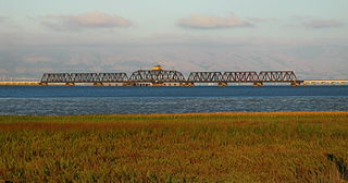
The Dumbarton Rail Corridor is a proposed transbay passenger rail line which would reuse the right-of-way that was initially constructed from 1907–1910 as the Dumbarton Cut-off. The Dumbarton Cut-off includes the first structure to span San Francisco Bay, the 1910 Dumbarton Rail Bridge, although the vintage Cut-off bridges would likely be replaced prior to activating new passenger service. Dumbarton Rail Corridor would provide service between Union City in the East Bay and Menlo Park on the Peninsula, with train service continuing to both San Francisco and San José along the existing Caltrain tracks. It has been in the planning stages since 1988, and would be the first above-ground transbay rail line since Key System electric trains stopped running on the lower deck of the Bay Bridge in 1958, and the first new transbay crossing of any kind since the completion of the Transbay Tube in 1974.

Winter Island is a 453-acre (183 ha) island in Suisun Bay, in the western Sacramento-San Joaquin River Delta. It is north of Pittsburg, separated from Browns Island to the west by a slough. It was private property, and contained one house. It is used as a duck hunting area, a wetland, and a dredging disposal area. In 2016 Winter Island was purchased by the California Department of Water Resources in order to restore the island as a tidal marsh. Winter Island is part of Contra Costa County, and managed by Reclamation District 2122. It is shown, labeled "Ruckels Island", on an 1850 survey map of the San Francisco Bay area made by Cadwalader Ringgold and an 1854 map of the area by Henry Lange.

The San Francisco Bay Salt Ponds are an approximately 16,500-acre (6,700 ha) part of the San Francisco Bay that have been used as salt evaporation ponds since the California Gold Rush era. Most of the ponds were once wetlands in the cities of Redwood City, Newark, Hayward and other parts of the bay.