San Juan, New Mexico

Last updated

San Juan, New Mexico
CDP
Nickname: 
San Juan Pueblo
Rio Arriba County New Mexico Incorporated and Unincorporated areas San Juan Highlighted.svg
Location of San Juan
Coordinates: 36°03′10″N106°04′14″W / 36.05278°N 106.07056°W / 36.05278; -106.07056 [1]
Country United States
State New Mexico
County Rio Arriba
Area
  Total0.6 sq mi (1.5 km2)
  Land0.6 sq mi (1.5 km2)
  Water0.0 sq mi (0.0 km2)
Elevation
[1]
5,656 ft (1,724 m)
Population
 (2000)
  Total592
  Density1,035.8/sq mi (399.9/km2)
Time zone UTC-7 (Mountain (MST))
  Summer (DST) UTC-6 (MDT)
Area code 505
FIPS code 35-68705
GNIS feature ID928804 [1]

San Juan or San Juan Pueblo [1] is a census-designated place (CDP) in Rio Arriba County, New Mexico, United States. The population was 592 at the 2000 census.

Contents

Geography

San Juan is located a few miles north of Espanola.

According to the United States Census Bureau, the CDP has a total area of 0.6 square mile (1.5 km2), all land.

Demographics

As of the census [2] of 2000, there were 592 people, 193 households, and 152 families residing in the CDP. The population density was 1,035.8 inhabitants per square mile (399.9/km2). There were 227 housing units at an average density of 397.2 per square mile (153.4/km2). The racial makeup of the CDP was 4.05% White, 0.34% African American, 84.97% Native American, 0.17% Asian, 7.60% from other races, and 2.87% from two or more races. Hispanic or Latino of any race were 27.03% of the population.

There were 193 households, out of which 39.9% had children under the age of 18 living with them, 40.9% were married couples living together, 27.5% had a female householder with no husband present, and 21.2% were non-families. 19.2% of all households were made up of individuals, and 6.2% had someone living alone who was 65 years of age or older. The average household size was 3.06 and the average family size was 3.39.

In the CDP, the population was spread out, with 31.4% under the age of 18, 8.6% from 18 to 24, 29.7% from 25 to 44, 19.4% from 45 to 64, and 10.8% who were 65 years of age or older. The median age was 32 years. For every 100 females, there were 86.8 males. For every 100 females age 18 and over, there were 76.5 males.

The median income for a household in the CDP was $26,667, and the median income for a family was $27,500. Males had a median income of $22,721 versus $19,250 for females. The per capita income for the CDP was $10,568. About 19.3% of families and 25.6% of the population were below the poverty line, including 40.4% of those under age 18 and 14.9% of those age 65 or over.

See also

Related Research Articles

<span class="mw-page-title-main">Tamalpais-Homestead Valley, California</span> Census-designated place in California, United States

Tamalpais-Homestead Valley is a census-designated place (CDP) in Marin County, California, United States. The population was 11,492 at the 2020 census.

<span class="mw-page-title-main">Carnuel, New Mexico</span> Census-designated place in New Mexico, United States

Carnuel is a census-designated place (CDP) in Bernalillo County, New Mexico, United States. The population was 1,232 at the 2010 Census. It is part of the Albuquerque Metropolitan Statistical Area.

<span class="mw-page-title-main">Beclabito, New Mexico</span> Census-designated place in San Juan County, New Mexico, United States

Beclabito is a census-designated place (CDP) in San Juan County, New Mexico, United States. The population was 317 at the 2010 census. It is part of the Farmington Metropolitan Statistical Area.

<span class="mw-page-title-main">Flora Vista, New Mexico</span> CDP in New Mexico, United States

Flora Vista is a census-designated place (CDP) in San Juan County, New Mexico, United States. The population was 1,383 at the 2000 census. It is part of the Farmington Metropolitan Statistical Area. Flora Vista was founded in 1877 by settlers from Colorado who built cabins along the Animas River. A post office was established the following year. The name derived from the view of wildflowers in the valley.

<span class="mw-page-title-main">Huerfano, New Mexico</span> CDP in New Mexico, United States

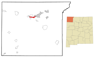
Huerfano is a census-designated place (CDP) in San Juan County, New Mexico, United States. The population was 104 at the 2000 census. It is part of the Farmington Metropolitan Statistical Area. Huerfano is named after El Huerfano Mountain, located a mile to the northeast.

<span class="mw-page-title-main">Kirtland, New Mexico</span> Town in New Mexico, United States

Kirtland is a town, made up of part of the former census-designated place (CDP) of the same name in San Juan County, New Mexico, United States. The population of the former CDP was 6,190 at the 2000 census. It is part of the Farmington Metropolitan Statistical Area.

<span class="mw-page-title-main">Nageezi, New Mexico</span> CDP in New Mexico, United States

Nageezi is a census-designated place (CDP) in San Juan County, New Mexico, United States. The population was 296 at the 2000 census. It is part of the Farmington Metropolitan Statistical Area. A post office was established in 1941. Nageezi's name in Navajo means "squash."

Napi Headquarters is a census-designated place (CDP) in San Juan County, New Mexico, United States. The population was 706 at the 2000 census.

<span class="mw-page-title-main">Naschitti, New Mexico</span> CDP in New Mexico, United States

Naschitti is a census-designated place (CDP) in San Juan County, New Mexico, United States. The population was 360 at the 2000 census. It is part of the Farmington Metropolitan Statistical Area. The town was established in 1886, when Tom Bryan set up a trading post east of the Chuska Mountains. With a Navajo name, Naschitti means "badger springs."

<span class="mw-page-title-main">Nenahnezad, New Mexico</span> CDP in New Mexico, United States

Nenahnezad is a census-designated place (CDP) in San Juan County, New Mexico, United States. The population was 726 at the 2000 census. Nenahnezad is a Chapter community just to the south of Fruitland, between the towns of Farmington and Shiprock. It is part of the Farmington Metropolitan Statistical Area.

<span class="mw-page-title-main">Newcomb, New Mexico</span> CDP in New Mexico, United States

Newcomb is a census-designated place (CDP) in San Juan County, New Mexico, United States. The population was 387 at the 2000 census. It is part of the Farmington Metropolitan Statistical Area.

<span class="mw-page-title-main">Ojo Amarillo, New Mexico</span> CDP in New Mexico, United States

Ojo Amarillo is a census-designated place (CDP) in San Juan County, New Mexico, United States. The population was 829 at the 2000 census. It is part of the Farmington Metropolitan Statistical Area.

<span class="mw-page-title-main">Sanostee, New Mexico</span> CDP in New Mexico, United States

Sanostee is a census-designated place (CDP) in San Juan County, New Mexico, United States. The population was 429 at the 2000 census. It is part of the Farmington Metropolitan Statistical Area.

<span class="mw-page-title-main">Sheep Springs, New Mexico</span> CDP in New Mexico, United States

Sheep Springs is a census-designated place (CDP) in San Juan County, New Mexico, United States. The population was 237 at the 2000 census. It is part of the Farmington Metropolitan Statistical Area.

<span class="mw-page-title-main">Upper Fruitland, New Mexico</span> CDP in New Mexico, United States

Upper Fruitland is a census-designated place (CDP) in San Juan County, New Mexico, United States. The population was 1,664 at the 2000 census. It is part of the Farmington Metropolitan Statistical Area.

Flying Hills is a census-designated place (CDP) in Cumru Township, Berks County, Pennsylvania. The population was 2,568 as of the 2010 census.

<span class="mw-page-title-main">North Alamo, Texas</span> Census-designated place in Texas, United States

North Alamo is a census-designated place (CDP) in Hidalgo County, Texas, United States. The population was 3,722 at the 2020 United States Census. It is part of the McAllen–Edinburg–Mission Metropolitan Statistical Area.

<span class="mw-page-title-main">Halchita, Utah</span> CDP in Utah, United States

Halchita is a census-designated place (CDP) in San Juan County, Utah, United States. The population was 270 at the 2000 census.

<span class="mw-page-title-main">Montezuma Creek, Utah</span> Census-designated place in Utah, United States

Montezuma Creek is a census-designated place (CDP) in San Juan County, Utah, United States. The population was 335 at the 2010 census, a decrease from the 2000 figure of 507.

<span class="mw-page-title-main">Oljato–Monument Valley, Utah</span> CDP in Utah, United States

Oljato-Monument Valley is a census-designated place (CDP) in San Juan County, Utah, United States. The population was 864 at the 2000 census.

References

  1. 1 2 3 4 U.S. Geological Survey Geographic Names Information System: San Juan, New Mexico
  2. "U.S. Census website". United States Census Bureau . Retrieved January 31, 2008.