You can help expand this article with text translated from the corresponding article in Spanish. (January 2023)Click [show] for important translation instructions.
Machine translation, like DeepL or Google Translate, is a useful starting point for translations, but translators must revise errors as necessary and confirm that the translation is accurate, rather than simply copy-pasting machine-translated text into the English Wikipedia.
Do not translate text that appears unreliable or low-quality. If possible, verify the text with references provided in the foreign-language article.
You must provide copyright attribution in the edit summary accompanying your translation by providing an interlanguage link to the source of your translation. A model attribution edit summary is Content in this edit is translated from the existing Spanish Wikipedia article at [[:es:Departamento de San Marcos]]; see its history for attribution.
You should also add the template {{Translated|es|Departamento de San Marcos}} to the talk page.
In 1546, once the Guatemalan archdiocese was established, bishop Francisco Marroquín split the ecclesiastical duties in the region among the Order of Preachers, Franciscans and Mercedarians, being the latter appointed to take care of "El Barrio" (in present-day San Marcos and Huehuetenango Departments), which was then a part of the Province of Quetzaltenango].[2] In 1609 the Captaincy General of Guatemala was established.
Tejutla was an important commercial and religious center; in August 1767, Joseph Domingo Hidalgo described Santiago Tejutla as "El Curato" -i.e., the focal center of commerce of all the towns that were around it− in the Gaceta de Guatemala, the official newspaper of the times. Then, in the last quarter of the 18th century, bishop Dr. Pedro Cortés y Larraz, who arrived from Cuilco in 1770 as part of the inspection he was doing of the Guatemalan dioceses, called Tejutla "Santiago en la Cima del Monte" (English: Santiago at the top of the hill" and reported that there were "sixty four families who lived very well" in the area.[4]
In 1754 the Mercedarians gave away their convent to the secular clergy per the Borbonic reforms that were instituted by the King of Spain, and Tejutla became a secular "curato".[5]
The department was created by a governmental decree on 8 May 1866, together with Huehuetenango, Izabal and Petén departments.[2] In 1902 the eruption of the Santa María volcano in the neighbouring department of Quetzaltenango was responsible for the destruction of the twin towns of San Marcos and San Pedro Sacatepéquez.[6] The towns were rebuilt and in 1935 were joined to form the new municipality of San Marcos La Unión.[6] This new municipality did not last long and the unified municipalities were again split in 1945 with San Marcos remaining the departmental capital.[6]
21st century
Towards the end of the 20th century, San Marcos became a hot spot for drug trafficking in Central America, and one of the top lords was Juan Chamalé Ortiz, who was heavily involved in cocaine trafficking, and was accused by US authorities of helping to move over 40 tons of cocaine through Central America en route to the United States. Ortiz worked with local fishermen to smuggle cocaine in small fishing boats and may have also commissioned semi-submersibles to transport the drug. Ortiz also controlled a major opium poppy producing area, the San Marcos Department, where he was a popular local figure. He owned at least ten estates in his area of operations, including a large farm in Malacatán and provided numerous jobs, in addition to cultivating local support by throwing parties and sponsoring beauty contests.[7]
San Marcos is one of the most important regions in Guatemala given its proximity to the highlands, Mexico, and to the Pacific Ocean coast, where most of the drugs coming from South America land. Ortiz exerted influence over local politicians and police in the region, and relied on a powerful local support network to conduct his business. He is thought to have worked out a deal that made him the Sinaloa Cartel's top transporter, helping the Mexican group move drugs that arrived via Pacific routes. Ortiz Chamalé was captured in 2011 in Quetzaltenango and extradited to the United States in 2014 where he was sentenced to 262 months in jail; when Ortiz was arrested in 2011, locals protested to demand his release.[7]
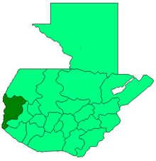
The department has a total territory of 2,397 square kilometres (925sqmi).[9]
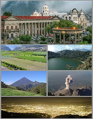
The northern portion of the department is mountainous, being crossed by the Sierra Madre de Chiapas mountain range. The two highest volcanoes in Central America being located within its borders,[8]Tajumulco (4,220 metres (13,850ft) high) and Tacaná (4,092 metres (13,425ft) high).[8][10] The Tajumulco volcano is the highest peak in Central America.[11] Other notable peaks include San Antonio Ichiguán at 4,022 metres (13,196ft)above mean sea level.[8][disputed–discuss] The southern portion of the department drops away towards the Pacific coast.[12]
The Tacaná volcano, which occupies the border with Mexico and has slopes in both countries, has been historically active, with activity recorded in 1855, 1878, from 1900 through to 1903, from 1949 to 1950 and from 1986 to 1987.[10]
Principal rivers in the department include the Suchiate River, which marks the border between San Marcos and Chiapas, Mexico, and flows into the Pacific Ocean.[12] The Cabuz River has its source on the slopes of the Tajumulco volcano.[12] Other rivers include the El Pajapa, El Rodeo, Ixlamá, Ixtal, Meléndrez, Nahuatán, Tilapa, and Ocosito Rivers.[12]
The climate varies widely within the department, due to the dramatic differences in altitude, with the north possessing a cold Guatemalan Highlands climate and the south having a temperate or hot climate, depending on the specific altitude.[12]
Population
The 2018 census recorded the total population of San Marcos department as 1,032,277.[1] Languages spoken in the department include Spanish, Mam and Sipakapense.[13]
Economy and agriculture
Finca El Platanillo coffee plantation, with the Tajmulco volcano behindFarming communities below Volcán Tajumulco in San Marcos.
The wide variety of climates within the department resulting from differences in altitude gives rise to a variety of agricultural products.[12] Agricultural products include apples, bananas, barley, beans, cacao, coffee, maize, oats, peaches, plantains, potatoes, rice, sugarcane and wheat.[14] Livestock include cattle, horses and sheep.[12] San Marcos department produces more wool than any other department of Guatemala.[12] It is generally exported to the departments of Quetzaltenango and Totonicapán, where it is processed into finished products.[12] The department produces wooden furniture, with production being concentrated in the Pacific lowlands due to the greater variety of wood available, including cedar, ceiba and tepemixte.[12]
The department is notable for the importation of black market Mexican products, which are sold openly in local markets throughout its territory and from there are exported throughout Guatemala.[15]
Municipalities
The department of San Marcos is divided into 30 municipalities:[13]
The main tourist attractions of the San Marcos department are its various Pacific beaches and the Tacaná and Tajumulco volcanoes.[9] Other attractions include thermal baths and the caves of Castalia.[9]
del Aguila, Juan Enrique (2005). San Marcos: Información Histórica-Geográfica del Departamento (in Spanish). Guatemala: Del Aguila Consultores.
Cortés y Larraz, Pedro (1770). Descripción Geográfico-Moral de la Diócesis de Goathemala (in Spanish). Guatemala: Diócesis de Guatemala.
Encyclopædia Britannica Online (2011). "Tajumulco Volcano". Encyclopædia Britannica. Encyclopædia Britannica Online. Retrieved 2011-01-14.
Fuentes y Guzmán, Francisco Antonio de (1932) [1690]. Recordación Florida. Discurso historial y demostración natural, material, militar y política del Reyno de Guatemala. Biblioteca Goathemala de la Sociedad de Geografía e Historia Volumen VI (in Spanish). Vol.I–III. Guatemala: Tipografía Nacional.
INSIVUMEH. "Volcanes de Guatemala" (in Spanish). Guatemala City: Instituto Nacional de Sismología, Vulcanología, Meteorologíá e Hidrologíá (INSIVUMEH) - Ministerio de Comunicaciones, Infraestructura y Vivienda. Retrieved 2011-01-14.
Guatemala is mountainous, except for the south coastal area and the vast northern lowlands of Petén department. The country is located in Central America and bounded to the north and west by Mexico, to the northeast by Belize and by the Gulf of Honduras, to the east by Honduras, to the southeast by El Salvador, and to the south by the Pacific Ocean. Two mountain chains enter Guatemala from west to east, dividing the country into three major regions: the highlands, where the mountains are located; the Pacific coast, south of the mountains; and the limestone plateau of the Petén region, north of the mountains. These areas vary in climate, elevation, and landscape, providing dramatic contrasts between hot and humid tropical lowlands and highland peaks and valleys.
Huehuetenango is one of the 22 departments of Guatemala. It is located in the western highlands and shares the borders with the Mexican state of Chiapas in the north and west; with El Quiché in the east, with Totonicapán, Quetzaltenango and San Marcos in the south. The capital is the city of Huehuetenango.
Quetzaltenango is a department in the western highlands of Guatemala. The capital is the city of Quetzaltenango, the second largest city in Guatemala. The department is divided up into 24 municipalities. The inhabitants include Spanish-speaking Ladinos and the Kʼicheʼ and Mam Maya groups, both with their own Maya language. The department consists of mountainous terrain, with its principal river being the Samalá River. the department is seismically active, suffering from both earthquakes and volcanic activity.
San Marcos (elevation: 7,868 feet is a city and municipality in Guatemala. It is the capital of the department of San Marcos. The municipality has a population of 47,063.
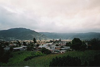
Chiantla is a town and municipality in the Guatemalan department of Huehuetenango. The municipality is situated at 2,000 metres above sea level and covers an area of 521 km2. The annual festival is on January 28.
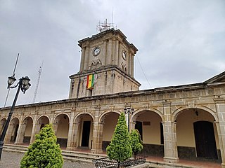
Jacaltenango is a town and municipality situated in the Western Highlands of Guatemala. It is located in a valley surrounded by the Sierra Madre Mountains. Jacaltenango serves as the municipal seat for the surrounding municipality of the same name. In 2002, its urban population was about 23,500 but at the 2018 census the town's population has decreased to 22,533.
San Juan Ostuncalco, is a town, with a population of 20,763, and a municipality in the Quetzaltenango department of Guatemala. Beside Spanish, local people speak the Mam language.
Comitancillo is a town and municipality in the San Marcos department of Guatemala.The spoken language is Mam.The municipality was founded by the Spaniards between 1633 and 1648 year. There is an archaeological site called Chipel, with remains of the Mam culture.
Concepción Tutuapa is a town and municipality in the San Marcos department of Guatemala. It had a population of 49,363 according to the census of 2002 and of the 2018 census there is a total population of 68,148.
Ixchiguán is a municipality in the San Marcos department of Guatemala. The economy is based on temporary work force on the coffee plantations, respectively on a male migrating work force in Mexico.
Malacatán is a town and municipality in the San Marcos department of Guatemala, located to the west of San Marcos town. It is fairly close to the border with Mexico - the border-crossing point is in the nearby village of El Carmen.
Tejutla is a municipality in the western highlands of Guatemala, in the department of San Marcos. Tejutla was officially founded on 25 July 1672, although it was already an important town within the Mam kingdom in 1524, at the time of the Spanish conquest of Guatemala. It is situated high in the mountains, the so-called "cold zone", at about 2500 m altitude.
San José Ojetenam is a municipality in the San Marcos department of Guatemala.
San Miguel Ixtahuacán is a municipality in the San Marcos department of Guatemala. It comprises 19 villages, and the population is about 39,000 people. The majority of people are ethnically Maya- Mam and speak the Mam and Spanish languages. Most inhabitants subsist by farming, growing crops of corn, beans, vegetables and fruits, irrigated from the Cuilco River and its tributaries.
Sibinal is a municipality in the San Marcos department of Guatemala. Its name comes from mam tziben (English: "Writing" and nal, meaning "Bernard writings" It was founded in February 1799. It is a mountainous municipality at an altitude about 2500 m near the Mexican-Guatemalan border. The village of Sibinal is one of the points for climbing towards the Volcano Tacaná.
Sipacapa is a municipality in the San Marcos department, situated in the Western highlands of Guatemala. Sipacapa's population of around 14,000 is spread among 14 village communities, scattered over mountainous terrain. Sipacapa is considered a linguistic community, as Sipakapense is a Maya language unique to the municipality.
Tacaná is a town and municipality in the Guatemalan department of San Marcos.
Tajumulco is a municipality in the San Marcos department of Guatemala.
Volcán Tajumulco is a large stratovolcano in the department of San Marcos in western Guatemala. It is the highest mountain in Central America at 4,203 metres (13,789 ft). It is part of the mountain range of the Sierra Madre de Chiapas, which begins in Mexico's southernmost state of Chiapas.
Volcán Siete Orejas is a stratovolcano in Guatemala located within the Quetzaltenango Department, in the municipalities of Quetzaltenango, Concepción Chiquirichapa, La Esperanza, and San Martin Sacatepequez. It is in the Sierra Madre de Chiapas.
This page is based on this Wikipedia article Text is available under the CC BY-SA 4.0 license; additional terms may apply. Images, videos and audio are available under their respective licenses.