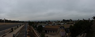
San Ysidro is a district of the City of San Diego, immediately north of the U.S.-Mexico border. It neighbors Otay Mesa West to the north, Otay Mesa to the east, and Nestor and the Tijuana River Valley to the west; together these communities form South San Diego, a practical exclave of the City of San Diego. Major thoroughfares include Beyer Boulevard and San Ysidro Boulevard.
The California chaparral and woodlands is a terrestrial ecoregion of southwestern Oregon, northern, central, and southern California and northwestern Baja California (Mexico), located on the west coast of North America. It is an ecoregion of the Mediterranean forests, woodlands, and scrub biome, and part of the Nearctic realm.

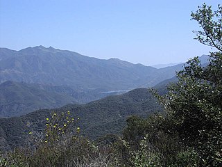
The Peninsular Ranges are a group of mountain ranges that stretch 1,500 km (930 mi) from Southern California to the southern tip of the Baja California Peninsula; they are part of the North American Coast Ranges, which run along the Pacific Coast from Alaska to Mexico. Elevations range from 150 to 3,300 m.
The Sierra Juárez and San Pedro Mártir pine–oak forests is a Nearctic temperate coniferous forests ecoregion that covers the higher elevations of the Sierra Juárez and Sierra San Pedro Mártir ranges of the Peninsular Ranges, of the northern Baja California Peninsula of Mexico. The pine–oak forests extend throughout the central portion of the Mexican state of Baja California and terminate near the border with the U.S. state of California.

South Bay, also known as South County, is a region in southwestern San Diego County, California consisting of the cities and unincorporated communities of Bonita, Chula Vista, Imperial Beach, Lincoln Acres, National City, and South San Diego.
Otay Mesa is a community in the southern section of the city of San Diego, just north of the U.S.–Mexico border.
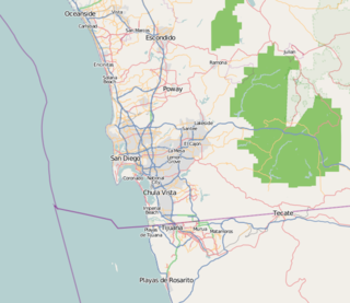
San Diego–Tijuana is an international transborder agglomeration, straddling the border of the adjacent North American coastal cities of San Diego, California, United States and Tijuana, Baja California, Mexico. The 2012 population of the region was 4,922,723, making it the largest bi-national conurbation shared between the United States and Mexico, the second-largest shared between the US and another country. In its entirety, the region consists of San Diego County in the United States and the municipalities of Tijuana, Rosarito Beach, and Tecate in Mexico. It is the third most populous region in the California–Baja California region, smaller only than the metropolitan areas of Greater Los Angeles and the San Francisco Bay Area.
South San Diego is a district within the City of San Diego, and is in the larger South Bay region of southwestern San Diego County, California. South San Diego is a practical exclave of San Diego, having no land connection with the rest of the city. It is the only part of the city which borders Mexico. South San Diego includes four of the city's official community planning areas: Otay Mesa, Otay Mesa-Nestor, San Ysidro, and the Tijuana River Valley.

Cupressus forbesii, now reclassified by some as Hesperocyparis forbesii, and with the common names Tecate cypress or Forbes' cypress, is a species of cypress native to southwestern North America.

Lepechinia ganderi is a rare species of perennial shrub in the mint family known by the common name San Diego pitcher sage or Gander's pitcher sage. An aromatic plant with white to lavender flowers, this species is only known from southern San Diego County in California and a small portion of Baja California, occurring on chaparral or coastal sage scrub in metavolcanic soils. Because of its limited range, it is under threat from growing urbanization and increased fire frequency.

Dudleya variegata is a deciduous succulent plant in the family Crassulaceae known by the common names variegated liveforever, variegated dudleya or rarely San Diego Hasseanthus. A cryptic plant that survives part of the year dormant underground from starch reserves in a corm, after sufficient rainfall, leaves will emerge, soon giving way to small inflorescences with yellow star-shaped flowers. It is native to Baja California and adjacent San Diego County in California, where it grows in several habitat types, including chaparral and vernal pools.

The California coastal sage and chaparral is a Mediterranean forests, woodlands, and scrub ecoregion located in southwestern California and northwestern Baja California (Mexico). It is part of the larger California chaparral and woodlands ecoregion.

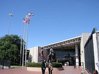
The San Ysidro Port of Entry is the largest land border crossing between San Diego and Tijuana, and the fourth-busiest land border crossing in the world with 70,000 northbound vehicles and 20,000 northbound pedestrians crossing each day, in addition to southbound traffic. It connects Mexican Federal Highway 1 on the Mexican side with Interstate 5 on the American side. The San Ysidro Port of Entry is one of three ports of entry in the San Diego–Tijuana metropolitan region.
Transportation in San Diego–Tijuana occurs by various means. Though, in the four cities of San Diego, Tijuana, Tecate, and Rosarito Beach, the automobile serves as most important means of transportation. The international metropolitan region maintains an intricate highway infrastructure. As a large metropolitan area in Western North America, many roadways, including Interstates, State Routes, and Mexican Federal Highways, hold a terminus in the area. These roads have grown accustomed to support the masses of the commuting populace within the international region and are constantly being expanded and/or renovated. Transportation is a crucial issue in the metropolitan area. The streets and highways of the region affect environmental health and have influence over the degree of regional connectivity. Binational discussions about coordinating public transportation across the border are currently underway. San Diego–Tijuana is the site of two major international airports and numerous regional airports. It is also the site of the Port of San Diego and miles from the nearby Port of Ensenada.
The Otay Mesa Port of Entry is one of three ports of entry (POE) in the San Diego–Tijuana metropolitan region, in the U.S. state of California, connecting Otay Mesa in the City of San Diego with the Otay Centenario borough of Tijuana. The facility was opened in 1983, and was constructed primarily to divert growing commercial truck traffic from the busy San Ysidro Port of Entry, located 5.2 miles (8.4 km) west. Since then, significant passenger vehicle and pedestrian traffic has grown as development in the area around the crossing has grown. Commercial importations through Otay Mesa accounts for billions of dollars' worth of freight.

The Tecate Port of Entry is one three ports of entry in the San Diego–Tijuana metropolitan region. The land port is located between Tecate, California in San Diego County's Mountain Empire and Tecate Municipality in Baja California. It connects California State Route 188 with Paseo Lázaro Cárdenas, a spur of Mexico Federal Highway 2, as well as Federal Highway 3 to the south. It is a minor port in comparison to the larger San Ysidro Port of Entry and Otay Mesa Port of Entry. This is attributed in part to the fact that reaching the crossing on the US side requires driving on narrow, winding mountain roads.
East Otay Mesa is an as-yet undeveloped area in the South Bay region of unincorporated San Diego County, southern California.

The Otay Mountain Wilderness is a U.S. Wilderness Area located in San Diego County, California, 12 miles east of the city of Otay Mesa and just north of the Mexican border. Some parts of the wilderness area rise quickly from sea level, reaching a peak of just over 3,500 feet (1,100 m) at the summit of Otay Mountain.

McGinty Mountain is a gabbroic mountain located in San Diego County, California near Jamul. Because of the gabbroic soil, the mountain supports numerous rare and endemic plant species, including half of the California's population of the Dehesa nolina. The mountain belongs to an ecological preserve collectively managed by The Nature Conservancy, the California Department of Fish and Wildlife, and the San Diego National Wildlife Refuge. The mountain is accessible through a 4.7 mi (7.6 km) long out-and-back hiking trail.
The Cerro Bola is a coastal metavolcanic mountain formation in northwestern Baja California. The Cerro Bola, along with the nearby mountain Cerro Gordo form the highest elevation areas of Tijuana Municipality. Because of its prominence, the transmitters for television station XHDTV and radio station XHPRS-FM are located on the summit of Cerro Bola, which reaches an elevation of 1,260 m (4,130 ft). It is located approximately 35 km (22 mi) south of the Tecate border crossing, and sits at the southwest end of the Valle de Las Palmas. The mountain range is host to a number of rare and endemic plant species, such as Arctostaphylos bolensis and Ceanothus bolensis.


