Baker County is a county in the U.S. state of Florida. As of the 2020 census, the population was 28,259. Its county seat is Macclenny. The county was founded in 1861 and is named for James McNair Baker, a judge and Confederate Senator.

Columbia County is a county located in the north central portion of the U.S. state of Florida. As of the 2020 census, the population was 69,698, up from 67,531 at the 2010 census. Its county seat is Lake City.

Lake County is a county in the central portion of the U.S. state of Florida. As of the 2020 census, the population was 383,956. Its county seat is Tavares, and its largest city is Clermont. Lake County is included in the Orlando–Kissimmee–Sanford Metropolitan Statistical Area.
Lee County is located in southwestern Florida, United States, on the Gulf Coast. As of the 2020 census, its population was 760,822. In 2022, the population was 822,453, making it the eighth-most populous county in the state. The county seat is Fort Myers, with a population of 86,395 as of the 2020 census, and the largest city is Cape Coral, with an estimated 2020 population of 194,016.

Sarasota County is a county located in Southwest Florida. At the 2020 US census, the population was 434,006. Its county seat is Sarasota and its largest city is North Port. Sarasota County is part of the North Port–Sarasota–Bradenton, FL metropolitan statistical area.
Union County is a county located in the north central portion of the U.S. state of Florida, the smallest in the state by area. As of the 2020 census, the population was 16,147. The county seat is Lake Butler. With a personal per capita income of $18,396, it is the poorest county in the United States.

Washington County is a county located in the northwestern part of the U.S. state of Florida, in the Panhandle. As of the 2020 census, the population was 25,318. Its county seat is Chipley.
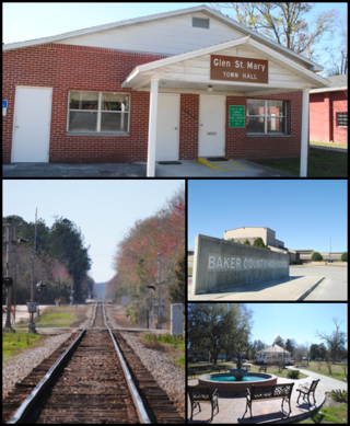
Glen St. Mary is a town in Baker County, Florida, United States. The Town of Glen St. Mary is part of the Jacksonville metropolitan area in North Florida. In 2020, the population recorded by the U.S. Census Bureau was 463.

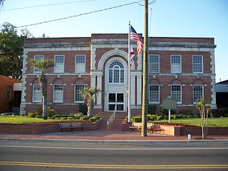
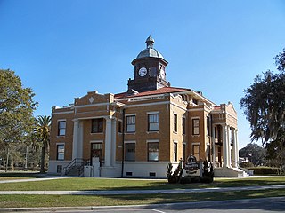
Macclenny is a city and the county seat of Baker County, Florida. Located just west of Jacksonville, it is one of the principal municipalities comprising Greater Jacksonville. The population was 7,304 at the 2020 census, up from 6,374 in 2010.

Weston is a city in Broward County, Florida, United States, just west of Fort Lauderdale. It is 31 miles (50 km) to the northwest of Miami and part of the Miami metropolitan area. The population was 68,107 at the 2020 census.
Inverness is a city and the county seat of Citrus County, Florida, United States. It is near the 10,950-acre (4,430 ha) Flying Eagle Preserve. As of the 2020 census, the population was 7,543.

Windermere is a town in Orange County, Florida, United States. As of the 2020 census, the town population was 3,030. It is part of the Orlando Metropolitan Statistical Area.

Palm Beach is an incorporated town in Palm Beach County, Florida, United States. Located on a barrier island in east-central Palm Beach County, the town is separated from West Palm Beach and Lake Worth Beach by the Intracoastal Waterway to its west and a small section of the Intracoastal Waterway and South Palm Beach to its south. It is part of the South Florida metropolitan area. As of the 2020 census, Palm Beach had a year-round population of 9,245.

Venice is a city in Sarasota County, Florida, United States. The city includes what locals call "Venice Island", a portion of the mainland that is accessed via bridges over the artificially created Intracoastal Waterway. The city is located in Southwest Florida. As of the 2020 Census, the city had a population of 25,463. Venice is part of the North Port–Sarasota–Bradenton metropolitan statistical area.

Huntsville is a town in Scott County, Tennessee, United States. The population was 1,270 at the 2020 census and 1,248 at the 2010 census. It is the county seat of Scott County.
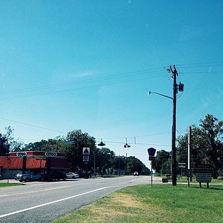
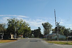
Olustee is an unincorporated area in Baker County, Florida, United States. The name "Olustee" is from the nearby Olustee Creek whose name derives from the Creek (Muscogee) language ue-lvste (/oy-lást-i/) meaning "black water". The town was historically known as Olustee Station and is the location of the Olustee Battlefield Historic State Park and of the ranger station for the Osceola National Forest, which is headquartered there. The US Forest Service has restored the former railroad depot at the center of town as a visitor center and museum for forest visitors.
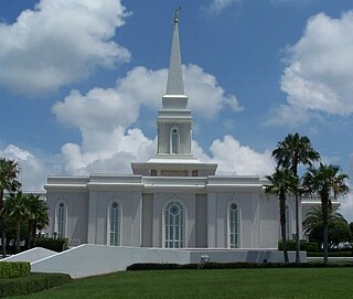
The Church of Jesus Christ of Latter-day Saints in Florida refers to the Church of Jesus Christ of Latter-day Saints and its members in Florida. The LDS Church represents about 1% of the population of Florida according to the Pew Research Center 2014 Religious Landscepe Survey. Official membership statistics show the church representing about 0.75% of the general population. Florida has the 8th largest membership population in the United States and the largest membership population east of the Mississippi. The LDS Church is the 6th largest denomination in Florida.

Baker is an unincorporated community in Okaloosa County, Florida, United States. It is located approximately 10 miles (16 km) northwest of the county seat, Crestview, in the Florida Panhandle. A stop on the Florida, Alabama and Gulf Railroad, Baker was platted in 1910 and grew up around the timber and turpentine industries.

John M. Bethea State Forest is a 37,736-acre state forest in Sanderson, Florida, in northern Baker County near the Florida/Georgia border. It provides a wildlife corridor between the Okefenokee National Wildlife Refuge and the Osceola National Forest. The area was acquired by the State of Florida in 2001, and was named after a member of the forestry department who served between 1970 and 1987.
Point Baker is an unincorporated community and census-designated place in Santa Rosa County, Florida, United States. Its population was 2,991 as of the 2010 census. Florida State Road 87 and Florida State Road 89 intersect in Point Baker.