Sandpoint, Idaho

Last updated

Sandpoint, Idaho
kamanqukuⱡ
Sandpoint Banner.JPG
Sandpoint Idaho from Schweitzer.jpg
Sandpoint id city beach.jpg
Sandpoint station.jpg
Sandpoint, ID.jpg
Top row: Cedar Street Bridge Public Market; 2nd row: Sandpoint from Schweitzer Mountain; City Beach; 3rd row: Sandpoint Amtrak Station; Downtown Sandpoint
Bonner County Idaho Incorporated and Unincorporated areas Sandpoint Highlighted 1672100.svg
Location of Sandpoint in Bonner County, Idaho.
Coordinates: 48°16′N116°34′W / 48.267°N 116.567°W / 48.267; -116.567
Country United States
State Idaho
County Bonner
Incorporation 1898
Area
[1]
  Total4.56 sq mi (11.81 km2)
  Land4.26 sq mi (11.05 km2)
  Water0.30 sq mi (0.77 km2)
Elevation
2,096 ft (639 m)
Population
 (2020) [2]
  Total8,639
  Density2,094/sq mi (808.46/km2)
Demonym Sandpointer
Time zone UTC-8 (Pacific (PST))
  Summer (DST) UTC-7 (PDT)
ZIP Code
83864
Area code(s) 208, 986
FIPS code 16-72100
GNIS feature ID0398095
Website www.cityofsandpoint.com

Sandpoint is the largest city in, and the county seat of, Bonner County, Idaho, United States. [3] Its population was 9,777 as of the 2022 census. [4]

Contents

Sandpoint's major economic contributors include forest products, light manufacturing, tourism, recreation and government services. As the largest service center in the two northern Idaho counties (Bonner and Boundary), as well as northwestern Montana, it has an active retail sector.

Sandpoint lies on the shores of Idaho's largest lake, 43-mile-long Lake Pend Oreille, and is surrounded by three major mountain ranges, the Selkirk, Cabinet and Bitterroot ranges. It is home to Schweitzer Mountain Resort, Idaho's largest ski resort, and is on the International Selkirk Loop and two National Scenic Byways (Wild Horse Trail and Pend Oreille Scenic Byway). Among other distinctions awarded by national media in the past decade, in 2011 Sandpoint was named the nation's "Most Beautiful Small Town" by Rand McNally and USA Today . [5]

History

Sandpoint in ca. 1940 -IDAHO-C-0049- Lake Pend Oreille - Sandpoint (50525460518).jpg
Sandpoint in ca. 1940

Salish Tribes, specifically the Kalispel, and the Kootenai, built encampments on the shore of Lake Pend Oreille every summer, fished, made baskets of cedar, and collected huckleberries before returning to either Montana or Washington in the fall. The encampments ended before 1930. [6]

The region was extensively explored by David Thompson of the North West Company starting in 1807. Disputed joint British/American occupation of the Columbia District led to the Oregon boundary dispute. This controversy ended in 1846 with the signing of the Oregon Treaty, whereby Britain ceded all rights to land south of the 49th parallel.

In the 1880s, the Northern Pacific Railroad brought European and Chinese settlement to the area.

In August 1888, 29-year-old author and civil servant Theodore Roosevelt visited Sandpoint on a caribou-hunting trip in the Selkirk Mountains. [7] Roosevelt documented what a rough-and-tumble environment "Sand Point" was at that time (and for many decades following).

Sandpoint was officially incorporated in 1898.

Timber harvesting and railroads drove the economy for nearly a century as loggers moved in from the over-harvested Great Lakes region. Several lumber companies operated in the region from as early as 1896 to present, the most notable being the Humbird Lumber Company which operated from 1900 to around 1944. The lumber companies bought land from the Northern Pacific Railroad and built a major mill at Sandpoint and adjacent Kootenai. Lumber company-owned railroads extended into many of the local drainages including Grouse Creek, Gold Creek and Rapid Lightning Creek. Although the trees were never exhausted in the area, Humbird Lumber succumbed to the low timber prices of the Great Depression.

"Stump ranches" were sold by Humbird to many families who slowly cleared much of the valley land of tree stumps. Farming and ranching became the third largest business in the area, behind lumber and railroads, prior to the "discovery" of Lake Pend Oreille as a sports fishery in the 1950s. The economy was given a boost during World War II from Farragut Naval Station, a training center for the US Navy located at the southwestern end of Lake Pend Oreille.

The opening of Schweitzer Mountain Resort in 1963 turned the area into a year-round tourism destination. The beauty of the surrounding Selkirk and Cabinet Mountains and Lake Pend Oreille has kept Sandpoint a tourist favorite for water sports, hunting, hiking, horseback riding, fishing and skiing.

In the 1980s and 1990s, 30 miles south of Sandpoint, the areas of Coeur d'Alene and Hayden Lake attracted nationwide publicity when white supremacist Neo-Nazi groups (most notably the Aryan Nations) set up headquarters in the area. Many Sandpoint residents reacted negatively to such groups; some formed the Bonner County Human Rights Task Force in opposition. In 2001, the Aryan Nations lost a lawsuit filed against them. [8] The lawsuit bankrupted the organization and forced them to give up their Hayden Lake property and disband. [9] In December 2011, Sandpoint became the first city in Idaho to pass an ordinance prohibiting discrimination in housing, employment and public accommodations based on sexual orientation or gender identity.

Community organizations stage a number of regionally known annual events, including Sandpoint Winter Carnival in February; the Lost in the 50s vintage car show in May; and the Festival at Sandpoint summer music festival in August. Sandpoint's historic vaudeville-era Panida Theater hosts frequent performing art events and an ongoing independent film series. The Music Conservatory of Sandpoint provides classical music classes and inaugurated its "Little Carnegie" concert hall in 2022. [10] A robust visual arts community supported by the Pend Oreille Arts Council also contributes to Sandpoint's reputation as a center for arts and culture in northern Idaho and the Inland Northwest.

Geography and climate

Sandpoint, Idaho
Climate chart (explanation)
J
F
M
A
M
J
J
A
S
O
N
D
 
 
4.9
 
 
32
20
 
 
3.1
 
 
38
23
 
 
2.8
 
 
46
28
 
 
2.1
 
 
57
34
 
 
2.3
 
 
66
40
 
 
2.3
 
 
73
46
 
 
1
 
 
82
49
 
 
1.2
 
 
81
47
 
 
1.7
 
 
71
41
 
 
2.6
 
 
57
34
 
 
4.3
 
 
42
28
 
 
4.6
 
 
34
23
Average max. and min. temperatures in °F
Precipitation totals in inches
Source: NOAA
Metric conversion
J
F
M
A
M
J
J
A
S
O
N
D
 
 
123
 
 
0
−7
 
 
80
 
 
3
−5
 
 
70
 
 
8
−2
 
 
53
 
 
14
1
 
 
59
 
 
19
5
 
 
57
 
 
23
8
 
 
25
 
 
28
9
 
 
30
 
 
27
8
 
 
43
 
 
21
5
 
 
67
 
 
14
1
 
 
109
 
 
5
−2
 
 
116
 
 
1
−5
Average max. and min. temperatures in °C
Precipitation totals in mm
Sandpoint, Idaho, on Lake Pend Oreille, with the August 2022 Elmo fire plume in the background Sandpoint and Lake Pend Oreille and Elmo fire plume aerial.jpg
Sandpoint, Idaho, on Lake Pend Oreille, with the August 2022 Elmo fire plume in the background

According to the United States Census Bureau, the city has a total area of 4.79 square miles (12.41 km2), of which 3.98 square miles (10.31 km2) is land and 0.81 square miles (2.10 km2) is water. [11]

Sandpoint has a fairly typical inland Northwestern humid continental climate (Köppen Dsb), with cold, snowy winters and dry summers with large diurnal temperature swings from hot in the day to very cool at night. The record low was −37 °F (−38 °C) on December 30, 1968, while the record high was 104 °F (40 °C) recorded on both July 20, 1923 and July 24, 1994. The wettest month was December 1933 with 11.99 inches (304.5 mm) of total precipitation and the most monthly snowfall 68.8 inches (174.8 cm) in January 1969.

Climate data for Sandpoint, Idaho (Sandpoint Experiment Station) (1991–2020 normals, extremes 1910–present)
MonthJanFebMarAprMayJunJulAugSepOctNovDecYear
Record high °F (°C)54
(12)
61
(16)
71
(22)
87
(31)
97
(36)
106
(41)
105
(41)
102
(39)
96
(36)
81
(27)
66
(19)
58
(14)
106
(41)
Mean daily maximum °F (°C)33.6
(0.9)
38.4
(3.6)
46.4
(8.0)
55.6
(13.1)
65.8
(18.8)
71.8
(22.1)
81.8
(27.7)
81.9
(27.7)
71.7
(22.1)
56.3
(13.5)
41.8
(5.4)
33.5
(0.8)
56.6
(13.7)
Daily mean °F (°C)28.3
(−2.1)
31.1
(−0.5)
37.5
(3.1)
45.0
(7.2)
53.8
(12.1)
59.6
(15.3)
66.7
(19.3)
65.9
(18.8)
57.0
(13.9)
45.2
(7.3)
35.3
(1.8)
28.1
(−2.2)
46.1
(7.8)
Mean daily minimum °F (°C)22.9
(−5.1)
23.7
(−4.6)
28.6
(−1.9)
34.5
(1.4)
41.8
(5.4)
47.5
(8.6)
51.6
(10.9)
49.8
(9.9)
42.4
(5.8)
34.1
(1.2)
28.9
(−1.7)
22.8
(−5.1)
35.7
(2.1)
Record low °F (°C)−31
(−35)
−31
(−35)
−10
(−23)
9
(−13)
22
(−6)
28
(−2)
33
(1)
28
(−2)
16
(−9)
4
(−16)
−10
(−23)
−37
(−38)
−37
(−38)
Average precipitation inches (mm)4.33
(110)
2.91
(74)
3.58
(91)
2.37
(60)
2.72
(69)
2.44
(62)
1.17
(30)
0.80
(20)
1.41
(36)
2.95
(75)
4.72
(120)
4.61
(117)
34.01
(864)
Average snowfall inches (cm)20.9
(53)
8.4
(21)
6.5
(17)
0.5
(1.3)
0.0
(0.0)
0.0
(0.0)
0.0
(0.0)
0.0
(0.0)
0.0
(0.0)
0.0
(0.0)
6.4
(16)
19.3
(49)
62.0
(157)
Average precipitation days (≥ 0.01 in)15.812.313.611.611.310.85.54.77.311.314.215.2133.6
Average snowy days (≥ 0.1 in)9.25.03.90.60.00.00.00.00.00.13.39.331.4
Source: NOAA [12] [13]

Demographics

Historical population
CensusPop.Note
1910 2,993
1920 2,876−3.9%
1930 3,29014.4%
1940 4,35632.4%
1950 4,265−2.1%
1960 4,3552.1%
1970 4,144−4.8%
1980 4,4607.6%
1990 5,20316.7%
2000 6,83531.4%
2010 7,3657.8%
2020 8,63917.3%
U.S. Decennial Census [14] 2020 [2]

The median income between 2016 and 2020 for a household in the city was $46,712. The per capita income for the city was $28,210. The percentage of persons below the poverty line (2016–2020) was 14.7%.

The median value of owner-occupied housing in the city was $228,800. The homeownership rate (2006–2010) was 49.6%.

Of the population over 25 years of age (2006–2010), 89.9% had graduated high school, 25.6% had achieved a bachelor's degree or higher.

2010 census

As of the census [15] of 2010, there were 7,365 people, 3,215 households, and 1,811 families residing in the city. The population density was 1,850 inhabitants per square mile (714.3/km2). There were 3,769 housing units at an average density of 947 per square mile (365.6/km2). The racial makeup of the city was 95.5% White, 0.1% African American, 0.7% Native American, 0.8% Asian, 0.5% from other races, and 2.2% from two or more races. Hispanic or Latino of any race were 2.9% of the population.

There were 3,215 households, of which 29.3% had children under the age of 18 living with them, 39.4% were married couples living together, 12.3% had a female householder with no husband present, 4.7% had a male householder with no wife present, and 43.7% were non-families. 36.3% of all households were made up of individuals, and 15.1% had someone living alone who was 65 years of age or older. The average household size was 2.20 and the average family size was 2.86.

The median age in the city was 38.8 years. 23.3% of residents were under the age of 18; 8.1% were between the ages of 18 and 24; 26.2% were from 25 to 44; 25.9% were from 45 to 64; and 16.7% were 65 years of age or older. The gender makeup of the city was 48.2% male and 51.8% female.

Politics

Presidential elections results
Previous presidential elections results [16]
Year Republican Democratic Third parties
2020 47.1% 214849.9%22753% 138
2016 44.7%164644.3% 163011% 406
Statewide elections results
Previous statewide elections results [16]
Year Republican Democratic Third parties
2020 Senate 46.8% 211349.8%22483.4% 155
2018 Governor 40.2% 134057.8%19252% 65
2018 Lt. Governor41.9% 136558.1%18900% 0
2018 Attorney General45.5% 146154.5%17500% 0
2016 Senate 51.2%186344.5% 16194.2% 154
Marina on the waterfront WindbagMarina.JPG
Marina on the waterfront

Economy

Since 2002, Sandpoint has been home to aircraft manufacturer Quest Aircraft. [17]

Education

Sandpoint High School Sandpoint High Exterior.JPG
Sandpoint High School

Sandpoint is part of the Lake Pend Oreille School District. Sandpoint High School and Lake Pend Oreille Alternative High School educate students in grades 9 through 12.

Forrest Bird Charter School educates grades 6–12. History - First school in Sand Point all grades whose teacher was, Mary Murphy, wife of homesteader Thomas Murphy whose spring was used by the state fish hatchery for its water supply on opposite side of the lake. Property passed to Mary and then three of four sons, Leo, Ernest, and Arthur (who later became state senator and leader of the Democratic Party until 1977), oldest son, Charles (later a county commissioner) who had a nearby homestead. Arthur retained a spring on his property. On Arthur's death the property and spring passed to Terrence Murphy, Arthur's youngest son.

Rail transportation

Sandpoint Amtrak station Sandpoint station.jpg
Sandpoint Amtrak station

Amtrak's Empire Builder carries passengers daily in both directions between Chicago, Illinois to the east and Seattle, Washington and Portland, Oregon to the west. [18] Sandpoint's Amtrak station serves as the only stop in Idaho.

Sandpoint is on the main line of the BNSF Railroad, 80 railroad miles northeast of Spokane. Traffic flow was improved in 2023 by paralleling a 2.2-mile segment including the lake crossing that had been constricted by a single-track bridge. [19]

Local media

Radio
Television

Television stations serving Sandpoint originate from the Spokane, Washington market:

Print

Notable people

Related Research Articles

<span class="mw-page-title-main">Pend Oreille County, Washington</span> County in Washington, United States

Pend Oreille County is a county located in the northeast corner of the U.S. state of Washington, along the Canada–US border. As of the 2020 census, the population was 13,401. The county seat and largest city is Newport.

<span class="mw-page-title-main">Bonner County, Idaho</span> County in Idaho, United States

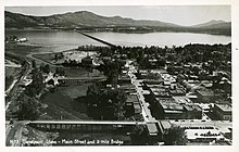
Bonner County is a county in the northern part of the U.S. state of Idaho. As of the 2020 census, the population was 47,110. The county seat and largest city is Sandpoint. Partitioned from Kootenai County and established in 1907, it was named for Edwin L. Bonner, a ferry operator.

<span class="mw-page-title-main">Clark Fork, Idaho</span> City in Idaho, United States

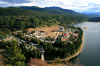
Clark Fork is a small town in Bonner County, Idaho. The population was 536 at the time of the 2010 census.

<span class="mw-page-title-main">Hope, Idaho</span> City in Idaho, United States

Hope is a city in Bonner County, Idaho, United States. The population was 86 at the 2010 census.

<span class="mw-page-title-main">Oldtown, Idaho</span> City in Idaho, United States

Oldtown is a city in Bonner County, Idaho and suburb of Newport, Washington, with a population of 184 at the 2010 census. It is located on the Pend Oreille River, just east of Newport. There are no natural or physical barriers, and it is strictly a political division, separated by the straight-line state boundary. Oldtown is squeezed between this boundary to the west and the river to the east, leaving the main business district on U.S. Route 2 with only 700 feet of space in which to operate on the Idaho side. Many homes are located in the south end on the other side of the railroad, as the Pend Oreille is somewhat further away here.

<span class="mw-page-title-main">Priest River, Idaho</span> City in Idaho, United States

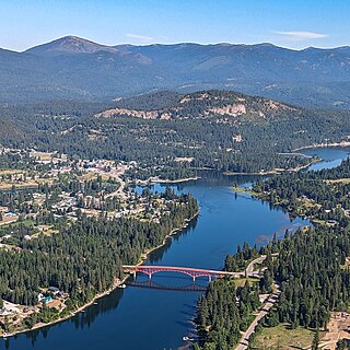
Priest River is a city in Bonner County, Idaho. The population was 1,751 at the 2010 census. Located in the Idaho Panhandle region of the state, the city is at the mouth of the Priest River on the Pend Oreille River.

<span class="mw-page-title-main">Bonners Ferry, Idaho</span> City in Idaho

Bonners Ferry is the largest of two cities in and the county seat of Boundary County, Idaho, United States. The population was 2,543 at the 2010 census.

<span class="mw-page-title-main">Athol, Idaho</span> City in Kootenai County, Idaho, United States

AtholAH-thol; is a city in Kootenai County, Idaho, United States. The population was 709 at the 2020 census, up from 692 in the 2010 census. It is part of the Coeur d'Alene Metropolitan Statistical Area, which includes the entire county. Its main attraction is Silverwood Theme Park.

<span class="mw-page-title-main">Ione, Washington</span> Town in Pend Oreille County, Washington, United States

Ione is a town in Pend Oreille County, Washington, United States. The population was 428 at the 2020 census.

<span class="mw-page-title-main">Metaline Falls, Washington</span> Town in Pend Oreille County, Washington, United States

Metaline Falls is a town in Pend Oreille County, Washington, United States. The population was 272 at the 2020 census.

<span class="mw-page-title-main">Pend Oreille River</span> River, tributary of the Columbia

The Pend Oreille River is a tributary of the Columbia River, approximately 130 miles (209 km) long, in northern Idaho and northeastern Washington in the United States, as well as southeastern British Columbia in Canada. In its passage through British Columbia its name is spelled Pend-d'Oreille River. It drains a scenic area of the Rocky Mountains along the U.S.-Canada border on the east side of the Columbia. The river is sometimes defined as the lower part of the Clark Fork, which rises in western Montana. The river drains an area of 66,800 square kilometres (25,792 sq mi), mostly through the Clark Fork and its tributaries in western Montana and including a portion of the Flathead River in southeastern British Columbia. The full drainage basin of the river and its tributaries accounts for 43% of the entire Columbia River Basin above the confluence with the Columbia. The total area of the Pend Oreille basin is just under 10% of the entire 258,000-square-mile (670,000 km2) Columbia Basin. Box Canyon Dam is currently underway on a multimillion-dollar project for a fish ladder.

<span class="mw-page-title-main">Pend d'Oreilles</span>

The Pend d'Oreille or Pend d'Oreilles, also known as the Kalispel, are Indigenous peoples of the Northwest Plateau. Today many of them live in Montana and eastern Washington of the United States. The Kalispel peoples referred to their primary tribal range as Kaniksu.
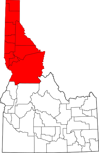
<span class="mw-page-title-main">Idaho panhandle</span> Region of the U.S. state of Idaho

The Idaho panhandlelocally known as North Idahoor Northern Idaho—is a salient region of the U.S. state of Idaho encompassing the state's 10 northernmost counties: Benewah, Bonner, Boundary, Clearwater, Idaho, Kootenai, Latah, Lewis, Nez Perce, and Shoshone. The panhandle is bordered by the state of Washington to the west, Montana to the east, and the Canadian province of British Columbia to the north. The Idaho panhandle, along with Eastern Washington, makes up the region known as the Inland Northwest, headed by its largest city, Spokane, Washington.

<span class="mw-page-title-main">Lake Pend Oreille</span> Lake in Kootenai and Bonner counties in Idaho, United States

Lake Pend Oreille in the northern Idaho Panhandle is the largest lake in the U.S. state of Idaho and the 38th-largest lake by area in the United States, with a surface area of 148 square miles (380 km2). It is 69 kilometres (43 mi) long, and 1,152 feet (351 m) deep in some regions, making it the fifth-deepest in the nation and having a volume of 43,939,940 acre feet = 54 km3. The lake is fed by the Clark Fork River and the Pack River, and drains into the Pend Oreille River, as well as subsurfacely into the Spokane Valley–Rathdrum Prairie Aquifer. It is surrounded by national forests and a few small towns, with the largest population on the lake at Sandpoint. The majority of the shoreline is non-populated and all but the southern tip of the lake is in Bonner County. The southern tip is in Kootenai County and is home to Farragut State Park, formerly the Farragut Naval Training Station during World War II, of which a small part is still active and conducts U.S. Navy acoustic underwater submarine research.

The Pack River is a medium-sized river located in Northern Idaho. It is about 40 miles (64 km) long and drains a high mountainous area of the Idaho Panhandle's Rocky Mountains and Selkirk Mountains. The river flows into Lake Pend Oreille and is part of the Columbia River watershed via the Pend Oreille River.

<span class="mw-page-title-main">Kaniksu National Forest</span> National forest in the northwestern United States

The Kaniksu National Forest is a U.S. National Forest located in northeastern Washington, the Idaho Panhandle, and northwestern Montana. It is one of three forests that are aggregated into the Idaho Panhandle National Forests, along with the Coeur d'Alene National Forest and St. Joe National Forest. Kaniksu National Forest has a total area of 1,627,833 acres (6,587.6 km2). About 55.7% is in Idaho, 27.9% in Montana, and 16.4% in Washington.

<span class="mw-page-title-main">Idaho Panhandle National Forests</span> National forests in Idaho, United States

The Idaho Panhandle National Forests are a jointly administered set of three national forests located mostly in the U.S. state of Idaho. In 1973, major portions of the Kaniksu, Coeur d'Alene, and St. Joe National Forests were combined to be administratively managed as the Idaho Panhandle National Forests (IPNF). The IPNF consists of more than 2.5 million acres (10,000 km2) of public lands in the panhandle of north Idaho, with small areas extending into eastern Washington (4.7%) and western Montana (1.2%). The northernmost portion of the IPNF share a boundary with Canada. The Forest Supervisor's office is located in Coeur d'Alene, Idaho with district office's in Bonners Ferry, Sandpoint, Priest River, Fernan and Smelterville, and St. Maries and Avery.

The International Selkirk Loop is a 280-mile-long (450 km) scenic highway in the U.S. states of Idaho and Washington, as well as the Canadian province of British Columbia. The loop encircles the Selkirk Mountain Range, and offers several side trips aside from the main route. Included on the loop is the Kootenay Lake Ferry, the longest free ferry in the world. The portion of the loop in the United States has been designated an All-American Road by the United States Department of Transportation.

Bayview is an unincorporated community in the northwest United States, located in Kootenai County, Idaho, north of Coeur d'Alene. On the southwest shore of Lake Pend Oreille, Bayview is seven miles (11 km) east-northeast of Athol. The community is served by State Highway 54 and a post office with ZIP code 83803; its approximate elevation is 2,100 feet (640 m) above sea level. Nearby is Farragut State Park, formerly the Farragut Naval Training Station, a major training facility during World War II.

Pend Oreille Wildlife Management Area at 4,908 acres (19.86 km2) is an Idaho wildlife management area in Bonner County near Sandpoint. Much of the land that is now the WMA was licensed to the Idaho Department of Fish and Game by the U.S. Army Corps of Engineers in 1956 as mitigation for wildlife habitat impacted by the construction of Albeni Falls Dam. Additional land was purchased in 1974 and three more parcels were licensed in 1996. Acquisitions were completed in 1997 with funds from the Bonneville Power Administration.

References

  1. "2019 U.S. Gazetteer Files". United States Census Bureau. Retrieved July 9, 2020.
  2. 1 2 "2020 Census Data". data.census.gov.
  3. "Find a County". National Association of Counties. Retrieved June 7, 2011.
  4. "Census.gov QuickFacts Sandpoint, Idaho". April 11, 2024. Retrieved April 11, 2024.
  5. Bly, Laura (July 22, 2011). "The five best small towns in America". USA Today. Archived from the original on January 12, 2012. Retrieved September 17, 2011.
  6. Green, Bob. "History of Sandpoint, Idaho - Remembering The Indians". sandpoint.com. Archived from the original on June 28, 2010. Retrieved June 8, 2010.
  7. Gunter, Bob. "History of Sandpoint, Idaho - Teddy Roosevelt in Early Sandpoint". sandpoint.com. Retrieved June 8, 2010.
  8. "Attorney Morris Dees pioneer in using 'damage litigation' to fight hate groups". CNN. September 8, 2000. Archived from the original on October 8, 2007. Retrieved August 17, 2007.
  9. "Keenan v. Aryan Nations". Southern Poverty Law Center. 2000. Archived from the original on July 13, 2007. Retrieved August 17, 2007.
  10. Compton, Sandy. "Entertainment is back ... with a vengeance". Sandpoint Magazine. Retrieved February 14, 2023.
  11. "US Gazetteer files 2010". United States Census Bureau. Archived from the original on January 25, 2012. Retrieved December 18, 2012.
  12. "NOWData - NOAA Online Weather Data". National Oceanic and Atmospheric Administration. Retrieved December 13, 2023.
  13. "Summary of Monthly Normals 1991-2020". National Oceanic and Atmospheric Administration. Retrieved December 13, 2023.
  14. "Census of Population and Housing". Census.gov. Retrieved June 4, 2015.
  15. "U.S. Census website". United States Census Bureau . Retrieved December 18, 2012.
  16. 1 2 "Dave's Redistricting". davesredistricting.org. Retrieved July 7, 2021.
  17. "Quest Aircraft Company". Quest Aircraft Company. Retrieved June 8, 2010.
  18. amtrak.com
  19. Kelly, Bruce. "FIXING THE FUNNEL". Trains . Vol. 84, no. March 2024. Kalmbach Media. pp. 12–21.
  20. "John Craigie's New Album "October is The Kindest Month" is a Work of Art from Beginning To End". Jambandfriendly. October 11, 2011.
  21. Keyes, David (Winter 2019). "Kramer finally gets the call". SandpointMagazine.com. Keokee Co. Publishing, Inc. Retrieved January 16, 2023.
  22. Olson, Ben (January 13, 2017). "A Reader interview with Viggo Mortensen". SandpointReader.com. The Sanpoint Reader. Retrieved January 24, 2018.
  23. Genevieve pseudonym of Pezet, Genevieve; maiden name: White. Oxford University Press. 2011. doi:10.1093/benz/9780199773787.article.b00072263.{{cite book}}: |work= ignored (help)

Further reading