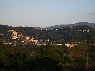
Roccavione is a comune (municipality) in the Province of Cuneo in the Italian region Piedmont, located about 90 kilometres (56 mi) south of Turin and about 9 kilometres (6 mi) southwest of Cuneo.

Altomonte is a town and comune in the province of Cosenza, in the Calabria region of southern Italy. It is one of I Borghi più belli d'Italia.
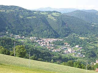
Camerana is a comune (municipality) in the Province of Cuneo in the Italian region Piedmont, located about 80 kilometres (50 mi) southeast of Turin and about 45 kilometres (28 mi) east of Cuneo.

Diano d'Alba is a comune (municipality) in the Province of Cuneo in the Italian region Piedmont, located about 50 kilometres (31 mi) southeast of Turin and about 50 kilometres (31 mi) northeast of Cuneo.
Isasca is a comune (municipality) in the Province of Cuneo in the Italian region Piedmont, located about 60 kilometres (37 mi) southwest of Turin and about 25 kilometres (16 mi) northwest of Cuneo, in the Valle Varaita.
Pezzolo Valle Uzzone is a comune (municipality) in the Province of Cuneo in the Italian region Piedmont, located about 70 kilometres (43 mi) southeast of Turin and about 50 kilometres (31 mi) northeast of Cuneo.
Salmour is a comune (municipality) in the Province of Cuneo in the Italian region Piedmont, located about 50 kilometres (31 mi) south of Turin and about 30 kilometres (19 mi) northeast of Cuneo. Salmour borders the following municipalities: Bene Vagienna, Cervere, Cherasco, Fossano, and Narzole.
Belforte Monferrato is a commune in the Province of Alessandria, region of Piedmont, Italy, located about 90 kilometres (56 mi) southeast of Turin and about 30 kilometres (19 mi) south of Alessandria.

Azzone is a comune (municipality) in the Province of Bergamo in the Italian region of Lombardy, located about 90 kilometres (56 mi) northeast of Milan and about 45 kilometres (28 mi) northeast of Bergamo. As of 31 December 2004, it had a population of 458 and an area of 16.8 square kilometres (6.5 sq mi).

Blello is a comune (municipality) in the Province of Bergamo in the Italian region of Lombardy, located about 50 kilometres (31 mi) northeast of Milan and about 15 kilometres (9 mi) northwest of Bergamo. As of 31 December 2004, it had a population of 91 and an area of 2.2 square kilometres (0.85 sq mi).

Boltiere is a comune (municipality) in the Province of Bergamo in the Italian region of Lombardy, located about 35 kilometres (22 mi) northeast of Milan and about 13 kilometres (8 mi) southwest of Bergamo. As of 31 December 2004, it had a population of 4,695 and an area of 4.1 square kilometres (1.6 sq mi).
Brusaporto is a comune (municipality) in the Province of Bergamo in the Italian region of Lombardy, located about 50 kilometres (31 mi) northeast of Milan and about 9 kilometres (6 mi) southeast of Bergamo. As of 31 December 2004, it had a population of 4,524 and an area of 5.0 square kilometres (1.9 sq mi).

Fontanella is a comune (municipality) in the Province of Bergamo in the Italian region of Lombardy, located about 50 kilometres (31 mi) east of Milan and about 30 kilometres (19 mi) southeast of Bergamo. As of 31 December 2004, it had a population of 3,773 and an area of 17.9 square kilometres (6.9 sq mi).

Foppolo is a comune (municipality) in the Province of Bergamo in the Italian region of Lombardy, located about 120 kilometres (75 mi) northeast of Milan and about 60 kilometres (37 mi) north of Bergamo. As of 31 December 2004, it had a population of 206 and an area of 16.2 square kilometres (6.3 sq mi).
Fuipiano Valle Imagna is a comune (municipality) in the Province of Bergamo in the Italian region of Lombardy, located about 50 kilometres (31 mi) northeast of Milan and about 20 kilometres (12 mi) northwest of Bergamo. On 30 November 2004, it had a population of 207 and an area of 4.2 square kilometres (1.6 sq mi).

Gandosso is a comune (municipality) in the Province of Bergamo in the Italian region of Lombardy, located about 60 kilometres (37 mi) northeast of Milan and about 20 kilometres (12 mi) southeast of Bergamo.
Gaverina Terme is a comune (municipality) in the Province of Bergamo in the Italian region of Lombardy, located about 70 kilometres (43 mi) northeast of Milan and about 20 kilometres (12 mi) northeast of Bergamo.

Gorle is a comune (municipality) in the Province of Bergamo in the Italian region of Lombardy, located about 50 kilometres (31 mi) northeast of Milan and about 4 kilometres (2 mi) east of Bergamo. As of 31 December 2004, it had a population of 5,506 and an area of 2.4 square kilometres (0.93 sq mi).
Osio Sotto is a comune (municipality) in the Province of Bergamo in the Italian region of Lombardy, located about 40 kilometres (25 mi) northeast of Milan and about 11 kilometres (7 mi) southwest of Bergamo. As of 31 December 2004, it had a population of 11,097 and an area of 7.5 square kilometres (2.9 sq mi).

San Giovanni Bianco is a comune (municipality) in the Province of Bergamo in the Italian region Lombardy, located about 60 kilometres (37 mi) northeast of Milan and about 20 kilometres (12 mi) north of Bergamo, located in the Val Brembana.


