Santo Stefano di Sessanio

Last updated

Santo Stefano di Sessanio
Comune di Santo Stefano di Sessanio
Santo Stefano di Sessanio 2013 by-RaBoe 013.jpg
View of Santo Stefano di Sessanio
Location of Santo Stefano di Sessanio
Santo Stefano di Sessanio
Italy provincial location map 2016.svg
Red pog.svg
Santo Stefano di Sessanio
Location of Santo Stefano di Sessanio in Italy
Italy Abruzzo location map.svg
Red pog.svg
Santo Stefano di Sessanio
Santo Stefano di Sessanio (Abruzzo)
Coordinates: 42°20′45″N13°38′42″E / 42.34583°N 13.64500°E / 42.34583; 13.64500
Country Italy
Region Abruzzo
Province L'Aquila (AQ)
Frazioni Barisciano, Calascio, Carapelle Calvisio, Castelvecchio Calvisio, Isola del Gran Sasso d'Italia (TE), L'Aquila
Government
  MayorFabio Santavicca
Area
[1]
  Total33.14 km2 (12.80 sq mi)
Elevation
1,250 m (4,100 ft)
Population
 (30 November 2014) [2]
  Total117
  Density3.5/km2 (9.1/sq mi)
Demonym Stefanari
Time zone UTC+1 (CET)
  Summer (DST) UTC+2 (CEST)
Postal code
67020
Dialing code 0862
ISTAT code 066091
Saint day3 August

Santo Stefano di Sessanio is a comune and hill town in the province of L'Aquila in the Abruzzo region of southern Italy. Located in the Gran Sasso e Monti della Laga National Park, in the highest region of the Apennines, this medieval hill town sits adjacent to the high plain of Campo Imperatore. It is one of I Borghi più belli d'Italia ("The most beautiful villages of Italy"). [3]

Contents

Population and economy

The tiny medieval village of Santo Stefano lay largely abandoned with many of its ancient buildings in ruins and only 70 inhabitants until recent years. Now, many of the village's buildings have been restored. Some comprise the Sextantio Albergo Diffuso, or extended hotel. Other structures have been restored as vacation homes. [4] The village's population as of 15 October 2020 was 115. [5] However, with its distance to Rome of 154 kilometres (96 mi) by car, or less than two hours' drive, the small village has become a fashionable weekend and summer retreat. Among its most notable part-time residents was Lucio Dalla, the Italian singer and songwriter. The village's main source of income is tourism with small boutiques, art galleries and eateries tucked into ancient stone structures.[ citation needed ] In the 21st century the ancient village had a rebirth thanks to tourism. In fact, in 1994 a young entrepreneur arrived in the village, Daniele Kihlgren, from Milan with Swedish origin, who bought a large part of the village to build a widespread hotel and, thanks to the project of conservative recovery of the landscape, traditions and buildings, he attracted the interest of the national and international press. This attracted new investors, significantly increasing all economic activities in the area.

Along with its neighbor Castel del Monte, Santo Stefano has been named one of Italy's prettiest villages, "I Borghi Piu belli D’Italia", and recognized by the Slow Food movement for its sustainable agriculture, in particular its gourmet lentils, "lenticchie". The town holds a festival on the first weekend in September of each year, the "Sagra delle Lenticchie", celebrating this food. [6]

History

“Sessanio" or "Sextantia", as it was called in Roman times, is the patron saint of the village. Many structures in the village date from the 11th through 15th centuries. In the 12th century, Santo Stefano was part of the Baronage of Carapelle, which included Castel del Monte, Calascio, Capestrano, Carapelle, Castelvecchio, Ofena, and Villa S. Lucia. The still standing village portal and now destroyed circular tower (the town's most notable architectural landmark) were constructed by the Medicis. The entrance portal, which leads to the village's main square, is emblazoned with the Medici coat of arms. Other historic structures include the Church of Santa Maria in Ruvo, Casa Fortezza, the Church of Santo Stefano, the ruins of the Palazzo Anelli, the Church of Santa Maria delle Grazie, and the Convent S. Maria del Monte. [7]

2009 earthquake

Santo Stefano di Sessanio's Medici Tower - before its collapse in the 6 April 2009 l'Aquila earthquake, the tower now lies in ruins Santo Stefano di Sessanio.jpg
Santo Stefano di Sessanio's Medici Tower – before its collapse in the 6 April 2009 l'Aquila earthquake, the tower now lies in ruins

In the 2009 L'Aquila earthquake, Santo Stefano lost its two most precious architectural prizes: its Medici Tower, the town's iconic symbol, which totally collapsed, and its 17th-century Church of the Madonna del Lago, which lost most of its front facade and suffered a major roof collapse. The hill town's other ancient masonry buildings largely survived although many suffered structural damage. [8] The Medici Tower is believed to have been rendered vulnerable to collapse because of 20th-century renovations to the tower's observation platform, which replaced a wooden deck with one made of reinforced concrete, thus making the tower top-heavy.

Main sights

Related Research Articles

<span class="mw-page-title-main">Abruzzo</span> Region in Italy

Abruzzo, historically known as Abruzzi, is a region of Southern Italy with an area of 10,763 square km and a population of 1.3 million. It is divided into four provinces: L'Aquila, Teramo, Pescara, and Chieti. Its western border lies 80 km (50 mi) east of Rome. Abruzzo borders the region of Marche to the north, Lazio to the west and north-west, Molise to the south and the Adriatic Sea to the east. Geographically, Abruzzo is divided into a mountainous area in the west, which includes the highest massifs of the Apennines, such as the Gran Sasso d'Italia and the Maiella, and a coastal area in the east with beaches on the Adriatic Sea.

<span class="mw-page-title-main">L'Aquila</span> Comune in Abruzzo, Italy

L'Aquila is a city and comune in central Italy. It is the capital city of both the Abruzzo region and of the Province of L'Aquila. As of 2023, it has a population of 69,558 inhabitants. Laid out within medieval walls on a hill in the wide valley of the Aterno river, it is surrounded by the Apennine Mountains, with the Gran Sasso d'Italia to the north-east.

<span class="mw-page-title-main">Gran Sasso d'Italia</span> Mountain located in central Italy

Gran Sasso d'Italia is a massif in the Apennine Mountains of Italy. Its highest peak, Corno Grande, is the highest mountain in the Apennines, and the second-highest mountain in Italy outside the Alps. The mountain lies within Gran Sasso e Monti della Laga National Park.

Santo Stefano is the Italian name of Saint Stephen.

<span class="mw-page-title-main">Province of L'Aquila</span> Province of Italy

The province of L'Aquila is the largest, most mountainous and least densely populated province of the Abruzzo region of Italy. It comprises about half the landmass of Abruzzo and occupies the western part of the region. It has borders with the provinces of Teramo to the north, Pescara and Chieti to the east, Isernia to the south and Frosinone, Rome and Rieti to the west. Its capital is the city of L'Aquila.

<span class="mw-page-title-main">Province of Teramo</span> Province of Italy

The province of Teramo is a province in the Abruzzo region of Italy. Its capital is the city of Teramo. The province has an area of 1,948 square kilometres (752 sq mi), a population of 313,029 (2012), and is subdivided into 47 comuni, see comunes of the province of Teramo. The province of Teramo shares its northern border with the province of Ascoli Piceno in the Marche region, southern and southwestern borders with the province of L'Aquila in the Abruzzo region, and a western border with the province of Rieti in the Lazio region. To the south is the province of Pescara in the Abruzzo region and to the east is the Adriatic Sea.

<span class="mw-page-title-main">Monti della Laga</span>

Monti della Laga is a mountain range in the central Apennines of Italy. Their ruggedness and inaccessibility makes them one of the lesser known areas of the Italian peninsula.

<span class="mw-page-title-main">Calascio</span> Comune in Abruzzo, Italy

Calascio is a comune and village in the province of L'Aquila, in the Abruzzo region of central Italy. It is located in the Gran Sasso e Monti della Laga National Park.

<span class="mw-page-title-main">Campotosto</span> Comune in Abruzzo, Italy

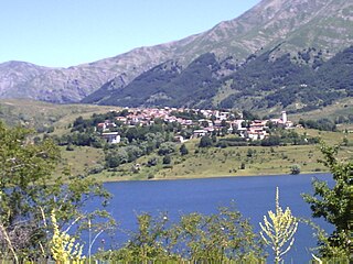
Campotosto is a comune and town in the province of L'Aquila, in the Abruzzo region of central Italy. Olympian Mariano Antonelli was born here.

<span class="mw-page-title-main">Carapelle Calvisio</span> Comune in Abruzzo, Italy

Carapelle Calvisio is a comune and town in the province of L'Aquila in the Abruzzo region of central Italy. It is located in the natural park known as the Gran Sasso e Monti della Laga National Park at 900 metres (3,000 ft) above sea level. It is mostly known as being one of the smallest non-alpine comunes in Italy, with 85 inhabitants as of 31 December 2013. This town is also the smallest community in Abruzzo. It is located directly some kilometers from the historical castle Rocca Calascio.

<span class="mw-page-title-main">Castel del Monte, Abruzzo</span> Hill town in Abruzzo, Italy

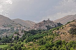
Castel del Monte is a medieval and Renaissance hill town and comune in the province of L'Aquila in northern Abruzzo, Italy. Located in the heart of the Gran Sasso mountain range, the town is set into a steep hillside nestled beneath mountain peaks near the high plain of Campo Imperatore. Castel del Monte sits opposite the ancient mountaintop fortress of Rocca Calascio and faces Monte Sirente in the distance. It is located in the Gran Sasso e Monti della Laga National Park. It is one of I Borghi più belli d'Italia.

<span class="mw-page-title-main">Montereale, Abruzzo</span> Comune in Abruzzo, Italy

Montereale is a comune and town in the province of L'Aquila, in the Abruzzo, region of Italy. It is located in the Gran Sasso e Monti della Laga National Park.

<span class="mw-page-title-main">Campo Imperatore</span>

Campo Imperatore is a mountain grassland or alpine meadow formed by a high basin shaped plateau located above Gran Sasso massif, the largest plateau of Apennine ridge. Known as "Little Tibet", it is located in Gran Sasso e Monti della Laga National Park, near L'Aquila, Abruzzo, Italy.

<span class="mw-page-title-main">Gran Sasso e Monti della Laga National Park</span>

The Gran Sasso and Monti della Laga National Park is a natural park in central Italy. Established in 1991, it covers an area of 2,014 square kilometres (778 sq mi), mostly within the provinces of Teramo, L'Aquila, and Pescara in Abruzzo, with small areas in the provinces of Rieti in Lazio and Ascoli Piceno in Marche. The terrain is predominantly mountainous with alpine plains.

<span class="mw-page-title-main">Capannelle Pass</span>

The Capannelle Pass is a mountain pass in Italy. It sits at an altitude of 1300 meters above sea level in the Province of L'Aquila in Italy's Abruzzo Region. It is located on the Italian State Highway 80 which passes near the Gran Sasso in the Apennines.

<span class="mw-page-title-main">Castle of Rocca Calascio</span> Mountaintop fortress in Abruzzo, Italy

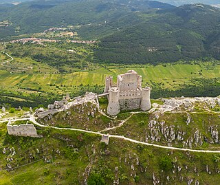
The Castle of Rocca Calascio is a mountaintop fortress or rocca in the municipality of Calascio, in the Province of L'Aquila, Abruzzo, Italy.

<span class="mw-page-title-main">Tourism in Abruzzo</span> Place

Tourism in Abruzzo has become one of the most prosperous sectors in the economy of Abruzzo, and in recent years has seen a remarkable growth attracting numerous tourists from Italy and Europe. According to statistics, in 2021 arrivals totaled 1,330,887. A total of 5,197,765 arrivals were tourists, a figure that puts the region seventeenth among the Italian regions for numbers of tourists per year. A moderate support to tourism is also given to the Abruzzo Airport with many low cost and charter flights connecting the entire region with the rest of Europe.

The following is a timeline of the history of the city of L'Aquila in the Abruzzo, a region of Italy.

<span class="mw-page-title-main">Assergi</span> Frazione in Abruzzo, Italy

Assergi is a frazione of the comune of L'Aquila, located about 11 km (6.8 mi) from the capital. With a population of just over 500, it is situated at an altitude of approximately 1,000 meters, below the western slope of the Gran Sasso in a small plain called the Piana di Assergi (Plain of Assergi). Assergi was formerly included in the comune of Camarda, which is directly to its south.

<span class="mw-page-title-main">Economy of Abruzzo</span>

Over the years, Abruzzo has become the most industrialized region of southern Italy and has had significant improvements and growth also at an economic level; the region has reached and surpassed many Italian regions in the specialization of the various industrial sectors and today it is the richest of the regions of Southern Italy.

References

  1. "Superficie di Comuni Province e Regioni italiane al 9 ottobre 2011". Italian National Institute of Statistics. Retrieved 16 March 2019.
  2. All demographics and other statistics from the Italian statistical institute (Istat)
  3. "Abruzzo" (in Italian). Retrieved 1 August 2023.
  4. Apennines are alive with the sound of saws and hammers
  5. SITO ISTITUZIONALE.
  6. Fondazione Slow Food per la Biodiversita (in Italian) [ permanent dead link ]
  7. Progetto SIMOCA ARSSA Abruzzo, Baronia di Carapelle Parco Nazionale Gran Sasso-Monti della Laga, Setting up and implementation of sustainable and multifunctional rural development model based on organic and competitive agriculture.
  8. Italy earthquake has caused 'incalculable' damage to cultural heritage