
Belize is a country on the north-eastern coast of Central America. It is bordered by Mexico to the north, the Caribbean Sea to the east, and Guatemala to the west and south. It also shares a water boundary with Honduras to the southeast. It has an area of 22,970 square kilometres (8,867 sq mi) and a population of 441,471 (2022). Its mainland is about 290 km (180 mi) long and 110 km (68 mi) wide. It is the least populated and least densely populated country in Central America. Its population growth rate of 1.87% per year is the second-highest in the region and one of the highest in the Western Hemisphere. Its capital is Belmopan, and its largest city is the namesake city of Belize City. Belize is often thought of as a Caribbean country in Central America because it has a history similar to that of English-speaking Caribbean nations. Belize's institutions and official language reflect its history as a British colony.

Central America is a subregion of the Americas. Its boundaries are defined as bordering Mexico to the north, Colombia to the south, the Caribbean Sea to the east, and the Pacific Ocean to the west. Central America usually consists of seven countries: Belize, Costa Rica, El Salvador, Guatemala, Honduras, Nicaragua, and Panama. Within Central America is the Mesoamerican biodiversity hotspot, which extends from northern Guatemala to central Panama. Due to the presence of several active geologic faults and the Central America Volcanic Arc, there is a high amount of seismic activity in the region, such as volcanic eruptions and earthquakes which has resulted in death, injury, and property damage.

Guatemala is mountainous, except for the south coastal area and the vast northern lowlands of Petén department. The country is located in Central America and bounded to the north and west by Mexico, to the northeast by Belize and by the Gulf of Honduras, to the east by Honduras, to the southeast by El Salvador, and to the south by the Pacific Ocean. Two mountain chains enter Guatemala from west to east, dividing the country into three major regions: the highlands, where the mountains are located; the Pacific coast, south of the mountains; and the limestone plateau of the Petén region, north of the mountains. These areas vary in climate, elevation, and landscape, providing dramatic contrasts between hot and humid tropical lowlands and highland peaks and valleys.

British Honduras was a Crown colony on the east coast of Central America, south of Mexico, from 1783 to 1964, then a self-governing colony, renamed Belize in June 1973, until September 1981, when it gained full independence as Belize. British Honduras was the last continental possession of the United Kingdom in the Americas.

The term territorial waters is sometimes used informally to refer to any area of water over which a sovereign state has jurisdiction, including internal waters, the territorial sea, the contiguous zone, the exclusive economic zone, and potentially the extended continental shelf. In a narrower sense, the term is used as a synonym for the territorial sea.
The Gulf or Bay of Honduras is a large inlet of the Caribbean Sea, indenting the coasts of Belize, Guatemala, and Honduras. From north to south, it runs for approximately 200 km from Dangriga, Belize, to La Ceiba, Honduras.

Serranilla Bank is a partially submerged reef, with small uninhabited islets, in the western Caribbean Sea. It is situated about 350 kilometres (220 mi) northeast of Punta Gorda, Nicaragua, and roughly 280 kilometres (170 mi) southwest of Jamaica. The closest neighbouring land feature is Bajo Nuevo Bank, located 110 kilometres (68 mi) to the east.

Bajo Nuevo Bank, also known as the Petrel Islands, is a small, uninhabited reef with some small grass-covered islets, located in the western Caribbean Sea at 15°53′N78°38′W, with a lighthouse on Low Cay at 15°51′N78°38′W. The closest neighbouring land feature is Serranilla Bank, located 110 kilometres to the west.

Roatán is an island in the Caribbean, about 65 kilometres (40 mi) off the northern coast of Honduras. It is located between the islands of Utila and Guanaja, and is the largest of the Bay Islands of Honduras. The island was formerly known in English as Ruatan and Rattan.

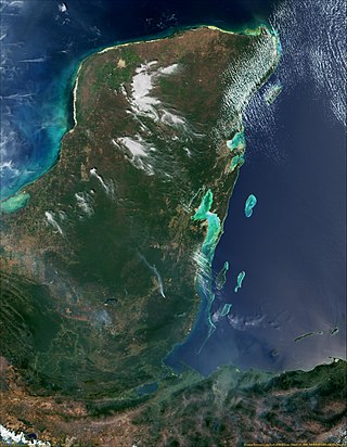
The Mesoamerican Barrier Reef System (MBRS), also popularly known as the Great Mayan Reef or Great Maya Reef, is a marine region that stretches over 1,126 kilometres (700 mi) along the coasts of four countries – Mexico, Belize, Guatemala, and Honduras – from Isla Contoy at the northern tip of the Yucatán Peninsula south to Belize, Guatemala and the Bay Islands of Honduras. The reef system includes various protected areas and parks including the Belize Barrier Reef, Arrecifes de Cozumel National Park, Hol Chan Marine Reserve (Belize), Sian Ka'an biosphere reserve, and the Cayos Cochinos Marine Park. Belize's coastline, including the Belize Barrier Reef, is home to approximately 30% of the Mesoamerican Barrier Reef System.
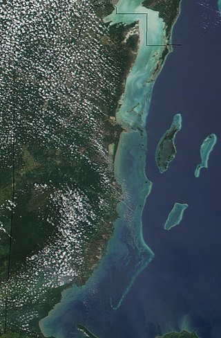
The Belize Barrier Reef is a series of coral reefs straddling the coast of Belize, roughly 300 metres (980 ft) offshore in the north and 40 kilometres (25 mi) in the south within the country limits. The Belize Barrier Reef is a 300-kilometre (190 mi) long section of the 900-kilometre (560 mi) Mesoamerican Barrier Reef System, which is continuous from Cancún on the north-eastern tip of the Yucatán Peninsula through the Riviera Maya and down to Honduras, making it the second largest coral reef system in the world after the Great Barrier Reef in Australia. It is Belize's top tourist destination, popular for scuba diving and snorkeling and attracting almost half of its 260,000 visitors. It is also vital to the country's fishing industry.

The Belizean–Guatemalan territorial dispute is an unresolved territorial dispute between the states of Belize and Guatemala, neighbours in Central America. During the late 1600s and throughout the 1700s, Britain and Spain signed several treaties regarding territories in the Americas. Both nations agreed that the territory was under Spanish sovereignty, but English settlers could use the land, in specific areas and for specific purposes. However, the area was never fully under British or Spanish occupation at this time. When the Spanish Empire fell, Guatemala said that they inherited Spain's sovereign rights over the territory. Since independence, Guatemala has claimed, in whole or in part, the territory of Belize.
Since declaring independence in 1981, Belize has enacted many environmental protection laws aimed at the preservation of the country's natural and cultural heritage, as well as its wealth of natural resources. These acts have established a number of different types of protected areas, with each category having its own set of regulations dictating public access, resource extraction, land use and ownership.

Tourism in Belize has grown considerably recently, and it is now the second largest industry in the nation. Belizean Prime Minister Dean Barrow has stated his intention to use tourism to combat poverty throughout the country. The growth in tourism has positively affected the agricultural, commercial, and finance industries, as well as the construction industry. The results for Belize's tourism-driven economy have been significant, with the nation welcoming almost one million tourists in a calendar year for the first time in its history in 2012.
The History of Belize dates back thousands of years. The Maya civilization spread into the area of Belize between 1500 BC to 1200 BC and flourished until about 1000 AD. Several Maya ruin sites, including Cahal Pech, Caracol, Lamanai, Lubaantun, Altun Ha, and Xunantunich reflect the advanced civilization and much denser population of that period. The first recorded European incursions in the region were made by Spanish conquistadors and missionaries in the 16th century. One attraction of the area was the availability of logwood, which also brought British settlers.
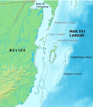
Glover's Reef is a partially submerged atoll located off the southern coast of Belize, approximately 45 kilometres from the mainland. It forms part of the outermost boundary of the Belize Barrier Reef, and is one of its three atolls, besides Turneffe Atoll and Lighthouse Reef.
Port Honduras Marine Reserve is a national protected marine reserve in the Toledo district of Belize. It was established in January 2000, and covers 40,470 hectares of mangrove and coastal ecosystems. It encompasses over one hundred small, mangrove-fringed cayes, benthic habitats comprising soft-bottom seagrass beds and fringing reefs.

Turneffe Atoll is located southeast of Ambergris Caye and Caye Caulker, off the coast of Belize in Central America, 20 miles from Belize City. It is one of three atolls of the Belize Barrier Reef, along with Glover's Reef and Lighthouse Reef. It is approximately 30 miles long and 10 miles wide, making it the largest coral atoll in Belize and in the Mesoamerican Barrier Reef System. The atoll was officially declared a marine reserve on November 22, 2012.

The extensive trade networks of the Ancient Maya contributed largely to the success of their civilization spanning three millennia. Maya royal control and the wide distribution of foreign and domestic commodities for both population sustenance and social affluence are hallmarks of the Maya visible throughout much of the iconography found in the archaeological record. In particular, moderately long-distance trade of foreign commodities from the Caribbean and Gulf Coasts provided the larger inland Maya cities with the resources they needed to sustain settled population levels in the several thousands. Though the ruling class essentially controlled the trade economy, a middle merchant class supervised import and export from cities and trade ports. Not much is known of the Maya merchant class; however, merchants of royal lineage are sometimes represented in the iconography. Notably, a canoe paddle often accompanies the royal merchant depictions, signifying their association with marine resources.

Sarstoon Island is an island at the southernmost point of Belize located near the mouth of the Sarstoon River. The Sarstoon River is located at the south of Sarstoon Island and is the southern part of the Belize–Guatemala border. Sarstoon Island is part of the Toledo District of Belize, which is one of 6 districts of the country. The island is mostly mangrove swampland and is uninhabited. It covers approximately 0.68 square kilometres (0.26 sq mi).


