Saunders Island, South Sandwich Islands

Last updated

Saunders Island
Saunders Island ASTER.jpg
SSI-Location.JPG
Location of Saunders Island
Geography
Coordinates 57°48′S26°29′W / 57.80°S 26.49°W / -57.80; -26.49 [1]
ArchipelagoSouth Sandwich Islands
Highest elevation990 m (3250 ft)
Highest point Mount Michael
Administration
United Kingdom
Demographics
PopulationUninhabited

Saunders Island is a crescent-shaped island lying between Candlemas Island and Montagu Island in the South Sandwich Islands, a British Overseas Territory in the southern Atlantic Ocean.

Contents

The 8.5 by 5 kilometres (5.3 mi × 3.1 mi) long Saunders is a volcanic island composed of an active stratovolcano, 990-metre (3,248 ft) Mount Michael, and a cluster of pyroclastic cones on the southeastern side. Mount Michael has a lava lake in its summit crater, which is fumarolically active, and there is widespread evidence of recent eruptions across the island.

The island is used as a breeding ground by many bird species, including penguins, but is barren of vegetation apart from lichens and some moss-covered patches. Most of the island is covered in ice.

Geography and geology

Regional

Saunders Island was discovered in 1775 by James Cook from HMS Resolution [2] and is part of the South Sandwich Islands in the southern Atlantic Ocean at the eastern end of the Scotia Sea. [3] They lie about 2,000 kilometres (1,200 mi) north of Antarctica and about the same distance south-east of the Falklands. [4] The islands are very remote and volcanic eruptions tend to go unnoticed, [5] and bad weather and hazardous oceanic conditions make landings difficult. [6] Politically, they are part of the British Overseas Territory of South Georgia and the South Sandwich Islands, [7] and tourist boats occasionally land on Saunders Island [8] which is accessible through several boulder beaches. [9] The waters around the island are fished commercially. [10]

East of the South Sandwich Islands, the Atlantic Ocean subducts in the South Sandwich Trench under the South Sandwich Plate [3] at a rate of 65–78 millimetres per year (2.6–3.1 in/year). [7] During the past five million years, this subduction process has given rise to the South Sandwich volcanic arc. This volcanic arc includes the Protector Shoal, [4] Kemp Caldera and Adventure Caldera seamounts [11] and numerous small islands [3] extending over a distance of about 350 kilometres (220 mi), [6] from north to south these are Zavodovski Island, Visokoi Island, Leskov Island, Candlemas Island-Vindication Island, Saunders Island, Montagu Island, Bristol Island, Bellingshausen Island-Cook Island-Southern Thule. [4] The largest islands are Saunders Island, Montagu Island and Bristol Island, [3] and most volcanoes (except for Vindication [11] ) have either fumarolic activity or historical eruptions. The islands are formed by layers of lava flows and pyroclastic rocks that form stratovolcanoes, their rocks have compositions ranging from basalt to basaltic andesite that define a calc-alkaline suite. [4]

Local

Saunders Island has dimensions of about 8.5 by 5 kilometres (5.3 mi × 3.1 mi) with a crescent-like shape. On the eastern side of the island, 6 kilometres (3.7 mi) wide Cordelia Bay opens to the northeast between Nattriss Point [lower-alpha 1] , [13] [14] a rocky headland, [12] to the east and Sombre Point to the north, with the Brothers Rocks 2 kilometres (1.2 mi) due north of Cordelia Bay [13] [14] and reefs especially on its northern side. [15] The southern part of the crescent west of Nattriss Point is formed by the inactive craters of the Ashen Hills which form a distinct topographic elevation; [16] the northern part of the crescent is blunter, [17] forming the highly conspicuous Yellowstone Crags, [18] Blackstone Plain and Harper Point, the northernmost point of Saunders Island. Between these lies the ice-covered bulk of the island with the 990 metres (3,250 ft) high Mount Michael volcano. To its west lies the small Carey Point peninsula and the larger Ollivant Point peninsula to the northwest. [14] The coasts are formed by cliffs, including ice cliffs, with inset bays and bouldery or sandy beaches. [17]

About 80% of the island is covered by ice. [19] Rocky outcrops occur at the coasts, eroded pyroclastic cones on the eastern side and the Mount Michael volcano. [3] Mount Michael is a steep-sided ice-covered conical stratovolcano [20] with a summit crater. The elevation of the summit of Mount Michael is mostly given as 990 metres (3,250 ft); [3] other reported heights are 843 metres (2,766 ft) [1] and 890 metres (2,920 ft). [21] The width of the summit crater is not precisely known but may reach about 700 metres (2,300 ft) [22] or 500 metres (1,600 ft). [21] The summit crater is surrounded by a second crater, conspicuous to the south [18] and southeast, [20] which is filled by ice. [21] It may be a caldera, [20] or a somma volcano. [1] A glacier descends on Mount Michael's eastern side, and the ice is full of crevasses. [23]

Cordelia Bay is about 30–50 metres (98–164 ft) [24] deep and does not appear to be a collapse scar or crater. [13] At Ollivant Point, there is a bouldery beach with boulder ridges. The ocean swells are high enough to frequently submerge the beach, which is surmounted by beach ridges. [25] The Ashen Hills consist of a cluster of overlapping pyroclastic cones [26] and feature tuff cones, which are uncharacteristic of South Sandwich Islands volcanoes that mostly lack evidence of highly explosive eruptions. [14] There are four craters; [18] the southern one has been partially eroded away [27] and river erosion in the Ashen Hills has formed gullies [17] that expose deposits from base surges. [28]

The island lies on the southern and southwestern side of a larger shallow shelf. It extends to the north to form Saunders Bank, while there are traces of past sector collapses on the western side, [29] and of submarine eruptions around the island, and of gullies formed by submarine erosion on the eastern side. [30] The shelf may have formed through wave erosion during periods of low sea level; other islands in the South Sandwich Islands have similar shelves. [24] Saunders Bank may be an eroded island that subsided over time. [31] Two northeast-southwest trending rows of seamounts are found north and southwest of Saunders Island; the northern consists of 480-metre (1,570 ft) deep Minke Seamount, 344-metre (1,129 ft) deep Orca Seamount and 75-metre (246 ft) deep Humpback Seamount, the southern of Saunders Island itself, 276-metre (906 ft) deep Fin Seamount and 400-metre (1,300 ft) deep Southern Right Seamount. [32] [29] Saunders Island reaches a width of 55 kilometres (34 mi) at 2,500 metres (8,200 ft) depth, [33] and several submerged ridges extend from it. [34]

Saunders Island has yielded basaltic rocks, [35] andesite is rare. [36] Basaltic andesite may be an older rock. [37] The basalts contain sometimes olivine; [38] phenocrysts include augite, hypersthene and plagioclase. Dolerite and gabbro have been found, and some volcanic rocks form palagonite. [39]

Eruption history

Older, more eroded rocks crop out at Carey Point and Nattriss Point. [20] Traces of former fumarolic activity are found at the northern plains. [40] Pahoehoe and aa lava flows were recently emplaced on the northern sector of the island, [41] surrounding the former shore cliffs [34] and sea stacks that constitute the Yellowstone Crags, [42] and forming the Blackstone Plain and Ollivant Point; they may have been erupted from the northern flank in the late 19th/early 20th century. [20] [1] [3] An ice gully described in 1931 was gone from images published in 2001 and may have formed during a 19th-20th century eruption. [20] Discrepancies in maps may imply that eruptions occurred in the Ashen Hills after 1820. Dark coloured layers of volcanic ash are embedded within the ice, presumably from explosive eruptions. [35]

Hot ground is found at both the summit crater and the southeastern crater. An ice tunnel in the caldera was filled with steam haze in 2001. [35] Gas is visibly emitted from the southeastern crater, [21] which was reported to be ice-free in 2013. [26] Renewed activity in the southeastern crater in 2006 generated a steam plume and the crater grew in size. [43] Steaming ground was seen close to the coast in 2020. [44] Activity is difficult to observe due to the weather conditions, hence it is assumed that eruptions are ongoing whenever there is evidence for activity within a ten-month timespan. [1]

Mount Michael is active, with fumarolic activity in the summit crater and occasional Strombolian eruptions that eject rocks to distances of several hundred metres [3] and deposit tephra on the eastern flanks. [21] Vapour emissions have been reported since 1820 [45] and often hide the summit crater from view. [35] Remote sensing has identified a lava lake in the summit crater of Mount Michael [21] with a surface area of about 0.01 square kilometres (0.0039 sq mi). The lake is mostly covered by a relatively cold crust (temperatures of a few hundred degrees Celsius) but the lava has temperatures of about 989–1,279 °C (1,812–2,334 °F). [46] It fluctuates in size over time. [47] The volcano emits at least 145±59 tons per day of sulfur dioxide [28] and about 179±76 tons per day of carbon dioxide. [48] Rime ice forms cauliflower-shaped masses on the summit, probably on top of fumaroles. [18]

Ecosystem

The South Sandwich Islands have a polar climate. [7] Storms and snowfall are frequent. [11] Between July and November sea ice is common. [49] Lichens are widespread. [50] Algae and nodding thread-moss form large colonies on the northern plains, the former in particular around penguin colonies. [51] Overall however, the island is largely barren of vegetation. [50]

Various bird species nest on Saunders Island, with the Ashen Hills and coastal areas of the extreme north and west of the island featuring large bird colonies. [52] Adelie penguins, black-bellied storm petrels, brown skuas, cape petrels, chinstrap penguins, Dominican gulls, gentoo penguins, macaroni penguins, snow petrels, southern fulmars, Wilson's storm petrels breed on the island, chinstrap penguins form a breeding population of more than 100,000 couples. Antarctic terns, king penguins and southern giant petrels visit the island, but without evidence of breeding. Antarctic fur seals and southern elephant seals are mammals that reproduce on Saunders Island, while Weddell seals have been observed but not while reproducing. [53] Penguin colonies occur mostly in the ice-free coastal areas, such as the Ashen Hills and Blackstone Plain. [54] Volcanic activity has caused mass mortalities in penguin colonies. [55]

A marine protected area was established around the South Sandwich Islands in 2012, with further areas added in 2019. [11] Marine debris has been reported from the beaches of Saunders Island. It consists mostly of driftwood but there is also man-made debris. [56]

See also

Notes

  1. Named after the shipping officer of the Discovery Committee, E.A. Nattriss. It was first charted by Bellingshausen in 1819 and re-charted by the Discovery Expedition in 1930. [12]

Related Research Articles

<span class="mw-page-title-main">Deception Island</span> Active volcanic island in the South Shetland archipelago

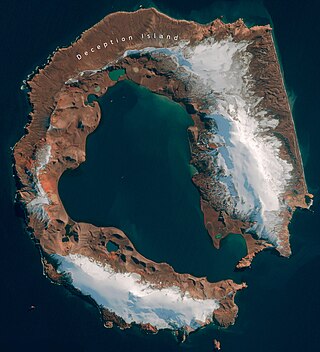
Deception Island is in the South Shetland Islands close to the Antarctic Peninsula with a large and usually "safe" natural harbor, which is occasionally affected by the underlying active volcano. This island is the caldera of an active volcano, which seriously damaged local scientific stations in 1967 and 1969. The island previously held a whaling station. It is now a tourist destination with over 15,000 visitors per year. Two research stations are operated by Argentina and Spain during the summer season. While various countries have asserted sovereignty, it is still administered under the Antarctic Treaty System.

<span class="mw-page-title-main">Vindication Island</span> Island in the South Sandwich Islands

Vindication Island is a small uninhabited island of the Candlemas Islands in the South Sandwich Islands. It is one of about a dozen islands that make up the South Sandwich island arc, a chain of volcanoes in the Southern Ocean that was discovered in 1775 by James Cook. The volcanism is caused by the subduction of the South American Plate beneath the Sandwich Plate.

<span class="mw-page-title-main">Mount Melbourne</span> Stratovolcano in the Antarctic

Mount Melbourne is a 2,733-metre-high (8,967 ft) ice-covered stratovolcano in Victoria Land, Antarctica, between Wood Bay and Terra Nova Bay. It is an elongated mountain with a summit caldera filled with ice with numerous parasitic vents; a volcanic field surrounds the edifice. Mount Melbourne has a volume of about 180 cubic kilometres (43 cu mi) and consists of tephra deposits and lava flows; tephra deposits are also found encased within ice and have been used to date the last eruption of Mount Melbourne to 1892 ± 30 years. The volcano is fumarolically active.

<span class="mw-page-title-main">Mount Takahe</span> Shield volcano in the Antarctic continent

Mount Takahe is a 3,460-metre-high (11,350 ft) snow-covered shield volcano in Marie Byrd Land, Antarctica, 200 kilometres (120 mi) from the Amundsen Sea. It is a c. 30-kilometre-wide (19 mi) mountain with parasitic vents and a caldera up to 8 kilometres (5 mi) wide. Most of the volcano is formed by trachytic lava flows, but hyaloclastite is also found. Snow, ice, and glaciers cover most of Mount Takahe. With a volume of 780 km3 (200 cu mi), it is a massive volcano; the parts of the edifice that are buried underneath the West Antarctic Ice Sheet are probably even larger. It is part of the West Antarctic Rift System along with 18 other known volcanoes.

<span class="mw-page-title-main">Mount Waesche</span> Volcano in Antarctica

Mount Waesche is a mountain of volcanic origin at the southern end of the Executive Committee Range in Marie Byrd Land, Antarctica. It is 3,292 metres high, and stands 20 kilometres southwest of Mount Sidley, the highest volcano in Antarctica. The mountain lies southwest of the Chang Peak caldera and is largely covered with snow and glaciers, but there are rock exposures on the southern and southwestern slopes.

<span class="mw-page-title-main">Bridgeman Island (South Shetland Islands)</span> Island in Antarctica

Bridgeman Island is one of the South Shetland Islands in Antarctica. It is an almost circular, volcanic island marked by steep sides, measuring 900 by 600 metres with a maximum elevation of 240 m (787 ft) high, lying 45 kilometres (28 mi) east of King George Island.

<span class="mw-page-title-main">Mount Belinda</span>

Mount Belinda is a stratovolcano on Montagu Island, in the South Sandwich Islands of the Scotia Sea. A part of the British Overseas Territory, South Georgia and the South Sandwich Islands, Mount Belinda is the highest peak in the South Sandwich Islands, at 1,370 m (4,490 ft).

<span class="mw-page-title-main">Protector Shoal</span> Submarine volcano NW of Zavodovski Island in the South Sandwich Islands

Protector Shoal is the shallowest point of the Protector Seamounts, a group of submarine volcanoes in the Southern Ocean. They are part of the South Sandwich island arc, a volcanic arc that has given rise to the South Sandwich Islands. Protector Shoal reaches a depth of 55 metres (180 ft) below sea level and is part of a larger group of seamounts that formed atop a larger ridge. Some of these seamounts bear traces of sector collapses, and one is capped by nested calderas.

Macdonald seamount is a seamount in Polynesia, southeast of the Austral Islands and in the neighbourhood of a system of seamounts that include the Ngatemato seamounts and the Taukina seamounts. It rises 4,200 metres (13,800 ft) from the seafloor to a depth of about 40 metres (130 ft) and has a flat top, but the height of its top appears to vary with volcanic activity. There are some subsidiary cones such as Macdocald seamount. The seamount was discovered in 1967 and has been periodically active with gas release and seismic activity since then. There is hydrothermal activity on Macdonald, and the vents are populated by hyperthermophilic bacteria.

<span class="mw-page-title-main">Vailuluʻu</span> Volcanic seamount in the Samoa Islands

Vailuluʻu is a volcanic seamount discovered in 1975. It rises from the sea floor to a depth of 593 m (1,946 ft) and is located between Taʻu and Rose islands at the eastern end of the Samoa hotspot chain. The basaltic seamount is considered to mark the current location of the Samoa hotspot. The summit of Vailuluʻu contains a 2 km wide, 400 m deep oval-shaped caldera. Two principal rift zones extend east and west from the summit, parallel to the trend of the Samoan hotspot. A third less prominent rift extends southeast of the summit.

Mount Rittmann is a volcano in Antarctica. Discovered in 1988–1989 by an Italian expedition, it was named after the volcanologist Alfred Rittmann (1893–1980). It features a 2 kilometres (1.2 mi) or 8 by 5 kilometres wide caldera which crops out from underneath the Aviator Glacier. The volcano was active during the Pliocene and into the Holocene, including large explosive eruptions; a major eruption occurred in 1254 CE and deposited tephra over much of Antarctica. Currently, the volcano is classified as dormant.

<span class="mw-page-title-main">Mount Berlin</span> Volcano in West Antarctica

Mount Berlin is a glacier-covered volcano in Marie Byrd Land, Antarctica, 100 kilometres (62 mi) from the Amundsen Sea. It is a roughly 20-kilometre-wide (12 mi) mountain with parasitic vents that consists of two coalesced volcanoes: Berlin proper with the 2-kilometre-wide (1.2 mi) Berlin Crater and Merrem Peak with a 2.5-by-1-kilometre-wide crater, 3.5 kilometres (2.2 mi) away from Berlin. The summit of the volcano is 3,478 metres (11,411 ft) above sea level. It has a volume of 200 cubic kilometres (48 cu mi) and rises from the West Antarctic Ice Sheet. It is part of the Marie Byrd Land Volcanic Province. Trachyte is the dominant volcanic rock and occurs in the form of lava flows and pyroclastic rocks.

Kemp Caldera and Kemp Seamount form a submarine volcano south of the South Sandwich Islands, in a region where several seamounts are located. The seamount rises to a depth of 80 metres (260 ft) below sea level; the caldera has a diameter of 8.3 by 6.5 kilometres and reaches a depth of 1,600 metres (5,200 ft). The caldera contains several Hydrothermal vents, including white smokers and diffuse venting areas, which are host to chemolithotrophic ecological communities. The seamount and caldera, which were discovered by seafloor mapping in 2009, are part of the South Georgia and the South Sandwich Islands Marine Protected Area.

<span class="mw-page-title-main">Leskov Island</span> Island in the South Sandwich Islands

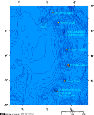
Leskov Island is one of the three Traversay Islands that form a subgroup of the South Sandwich Islands, in the South Atlantic Ocean.

<span class="mw-page-title-main">Southern Thule</span> Island group in the South Sandwich Islands

Southern Thule is a group of the three southernmost islands in the South Sandwich Islands in the southern Atlantic Ocean: Bellingshausen, Cook, and Thule (Morrell). It is a largely submerged volcano of which only the three islands emerge above sea level. Between Cook and Thule, and south of Bellingshausen, lie two submerged calderas; a third caldera is located on Thule. Cook Island is inactive and largely glaciated, while Bellingshausen and Thule feature active craters with fumarolic activity, and evidence of eruptions in the 20th century.

<span class="mw-page-title-main">Candlemas Island</span> Island of the Candlemas Islands in the South Sandwich Islands

Candlemas Island is a small uninhabited island of the Candlemas Islands in the South Sandwich Islands. It is one of about a dozen islands that make up the South Sandwich island arc, a chain of volcanoes in the Southern Ocean that was discovered in 1775 by James Cook. The volcanism is caused by the subduction of the South American Plate beneath the Sandwich Plate. The island is remote and rarely visited due to the often hostile weather conditions, but is populated by penguins and seabirds, which form large breeding colonies.

<span class="mw-page-title-main">Zavodovski Island</span> Volcanic island in the South Atlantic

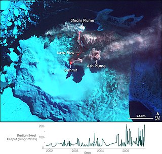
Zavodovski Island is an uninhabited volcanic island in the Traversay Islands subgroup of the South Sandwich Islands, which are located southeast of South Georgia in the South Atlantic Ocean. Zavodovski is the northernmost of the South Sandwich Islands and consists of one major stratovolcano, Mount Curry, which is surrounded to the east by a plain formed by lava flows. Mount Curry has a fumarolically active crater on the southwestern side, which also bears traces of a sector collapse. An eruption occurred in 2016.

<span class="mw-page-title-main">Visokoi Island</span> Uninhabited island in the South Sandwich Islands

Visokoi Island is an uninhabited volcanic island and one the three Traversay Islands that constitute a subgroup of the South Sandwich Islands, in the South Atlantic Ocean.

<span class="mw-page-title-main">Montagu Island</span> Largest of the South Sandwich Islands

Montagu Island is the largest of the South Sandwich Islands, located in the Scotia Sea off the coast of Antarctica. Almost entirely ice-covered with only sparse rocky outcrops, Montagu consists of a large caldera with a large parasitic cone, Mount Oceanite. Several secondary volcanic cones have formed in the caldera, including Mount Belinda.

<span class="mw-page-title-main">Bristol Island</span> Island in the South Sandwich Islands

Bristol Island is an uninhabited island in the South Sandwich Islands, an archipelago in the South Atlantic Ocean. The island is almost entirely surrounded by ice cliffs and largely covered with ice. It features both the oldest rocks of this archipelago and an active volcano that last erupted in 2016.

References

  1. 1 2 3 4 5 GVP 2023, General Information.
  2. Hart & Convey 2018, p. 20.
  3. 1 2 3 4 5 6 7 8 Gray, Burton-Johnson & Fretwell 2019, p. 61.
  4. 1 2 3 4 Patrick et al. 2005, p. 416.
  5. Patrick et al. 2005, p. 417.
  6. 1 2 Lachlan-Cope, Smellie & Ladkin 2001, p. 106.
  7. 1 2 3 Leat et al. 2016, p. 293.
  8. Hart & Convey 2018, p. 21.
  9. Rogers, Yesson & Gravestock 2015, p. 40.
  10. Rogers, Yesson & Gravestock 2015, p. 153.
  11. 1 2 3 4 Liu et al. 2020, p. 3.
  12. 1 2 USGS.
  13. 1 2 3 Leat et al. 2013, p. 64.
  14. 1 2 3 4 Lachlan-Cope, Smellie & Ladkin 2001, p. 107.
  15. Holdgate & Baker 1979, p. 42.
  16. Liu et al. 2020, p. 5.
  17. 1 2 3 Holdgate & Baker 1979, p. 39.
  18. 1 2 3 4 Holdgate & Baker 1979, p. 41.
  19. Convey et al. 2000, p. 1281.
  20. 1 2 3 4 5 6 Lachlan-Cope, Smellie & Ladkin 2001, p. 108.
  21. 1 2 3 4 5 6 Liu et al. 2020, p. 11.
  22. Patrick et al. 2005, p. 421.
  23. Liu et al. 2020, p. 4.
  24. 1 2 Leat et al. 2013, p. 73.
  25. Convey, Barnes & Morton 2002, p. 613.
  26. 1 2 Patrick & Smellie 2013, p. 485.
  27. Kemp 1932, p. 174.
  28. 1 2 Liu et al. 2020, p. 13.
  29. 1 2 Leat et al. 2016, p. 299.
  30. Leat et al. 2016, p. 301.
  31. Leat et al. 2013, p. 74.
  32. GVP 2023, Synonyms & Subfeatures.
  33. Leat et al. 2013, p. 63.
  34. 1 2 Leat et al. 2013, p. 66.
  35. 1 2 3 4 Lachlan-Cope, Smellie & Ladkin 2001, p. 109.
  36. Beniest & Schellart 2020, p. 9.
  37. Baker 1978, p. 12.
  38. Pearce et al. 1995, p. 1076.
  39. Baker 1978, Table III.
  40. Convey et al. 2000, p. 1287.
  41. Yamin & Anselmi 2020, p. 17.
  42. Baker 1978, p. 7.
  43. Patrick & Smellie 2013, p. 486.
  44. Liu et al. 2020, p. 12.
  45. Gray, Burton-Johnson & Fretwell 2019, p. 62.
  46. Gray, Burton-Johnson & Fretwell 2019, p. 68.
  47. Lachlan-Cope, Smellie & Ladkin 2001, p. 105.
  48. Liu et al. 2020, p. 20.
  49. Thorpe & Murphy 2022, p. 6.
  50. 1 2 Holdgate 1963, p. 404.
  51. Convey et al. 2000, p. 1289.
  52. Convey, Morton & Poncet 1999, p. 117.
  53. Hart & Convey 2018, p. 27.
  54. Holdgate & Baker 1979, p. 45.
  55. Hart & Convey 2018, p. 26.
  56. Convey, Barnes & Morton 2002, p. 614.

Sources