Save Aramoana Campaign

Last updated

The Save Aramoana Campaign was formed in 1974 to oppose a proposed aluminium smelter at Aramoana in New Zealand.

Contents

In the late 1970s Aramoana was proposed as the site of a major aluminium smelter by a consortium of New Zealand-based Fletcher-Challenge, Australia's CSR Limited and Swiss firm Alusuisse. [1] [2] [3] An aluminium smelter was already operating at Tiwai Point when the smelter at Aramoana was proposed.

Background

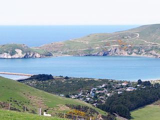
From its inception, the Otago Harbour Board had vested in it for harbour purposes, land on the northern side of the Otago Harbour entrance. This included a quarry for rock to build the mole that protected the entrance; the village, originally housing workers on the mole, and later leased out for holiday homes; a large area of salt marsh; and adjacent dry-land leased out for rough grazing.

After the Comalco Aluminium Smelter was opened at Bluff's Tiwai Point in 1971, Otago interests sought a similar project in 1974 on the OHB land at Aramoana. It was not well founded, and was withdrawn in the face of modest opposition.

That opposition remained alert to any unusual activity on the OHB land, and when surveyors were seen on the flats over the summer of 1979-80 conservation interests began to organize what became the Save Aramoana Campaign.

At the time the site was included in the Waikouaiti District Scheme, under zoning provisions of dubious legality and which a planner/economist with the campaign took to court for a declaratory judgment as to their legality. This had the effect of placing the whole project sub judice , and therefore unable to proceed. It cost $50.00 to lodge that action with the court, and when it became clear that the project would not be able to quietly proceed under the existing rules, the entire campaign for and against the smelter was thrust into the public arena.

The Government, keen to use the smelter to justify the Clyde Dam as part of its "Think Big" programme, passed the National Development Act. Waikouaiti, now combined with Taieri to become the Silverpeaks, brought out its own district scheme with much more legally sound provisions for industrial land use, specifically a smelter, at Aramoana. Those provisions were fought by the campaign's planner at the council level and on to the Planning Tribunal as Appeal no. 733/82, upheld by that court in decision C51/83 J.Todd and the Careys Bay Assn. v Silver Peaks County Council. The Court directed that " ... all reference to industrial development at Aramoana is to be deleted ... ".

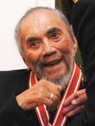
While the planning and legal battles were being fought the broader field saw the campaign kept on the public stage : the declaration of the Independent State of Aramoana allowed that notional entity to issue a collector's set of stamps. with original art work donated by leading New Zealand artists for the purpose, and these raised nearly NZ$500,000 in 1982 terms. The campaign was remarkably well funded. Several New Zealand artists were involved in the campaign in other ways, most notably Ralph Hotere, who produced the Aramoana series of paintings in response to the smelter issue.

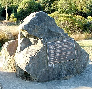
The public campaign also ensured that Government could not lightly face the serious political risk of bringing down a special Empowering Act to force the smelter through, as it had done with the Clyde High Dam. The tide had turned against Think Big, and the smelter was left to sink without trace. Pechiney had left, Alusuisse went off to look for a more congenial site in Zaire, and Aramoana saw the village made freehold and the saltmarsh gazetted as a reserve.

Independent State of Aramoana

Independent State of Aramoana
Unrecognized micronation
Independent-State-of-Aramoana-Stamp-Sheet.jpg
Stamps issued in 1981 by Aramoana to raise funds for the anti-smelter campaign. The design was based on the painting "Puketotara, Twice Shy" by New Zealand regionalist artist, Don Binney.
Area claimed Aramoana and Te Ngaru villages, South Island, New Zealand
Claimed byVillage residents
Dates claimedDecember 23, 1980–after October 1981

The smelter plan called for the destruction of the villages of Aramoana and Te Ngaru, and also threatened a local wildlife reserve. In response residents of the area announced their secession from New Zealand on 23 December 1980, established a "border post" and "travelling embassy", printed passports, citizenship certificates and postage stamps, [4] and set about using the resultant publicity to build a national grassroots campaign in opposition to the smelter. The campaign attracted the attention of artists such as Ralph Hotere, [5] as well as conservationists and heritage researchers such as Peter Entwisle. [6]

The consortium was endorsed by the New Zealand Government, [2] which initially proposed to subsidise the cost of electricity required for the smelter's operation, leading to fears that the wider population of New Zealand would be faced with significant electricity price hikes in the longer term. However, the campaign waged by the independent state supporters eventually forced a government backdown, calling into question the economic viability of the project.

This development combined with declining aluminium prices on world commodity markets, eventually led to the withdrawal of Alusuisse from the consortium in October, 1981. [3] The remaining partners failed to secure additional investment capital, and eventually abandoned the project, paving the way for the peaceful reintegration of the Independent State of Aramoana back into New Zealand. The proposal is still remembered as a divisive issue. [7]

See also

Related Research Articles

<span class="mw-page-title-main">Waikouaiti</span> Town in Otago, New Zealand

Waikouaiti is a small town in East Otago, New Zealand, within the city limits of Dunedin. The town is close to the coast and the mouth of the Waikouaiti River.

The Clyde Dam, New Zealand's second-largest hydroelectric dam, is built on the Clutha River / Mata-Au near the town of Clyde. It is owned and operated by Contact Energy.

<span class="mw-page-title-main">Bluff, New Zealand</span> Town in Southland, New Zealand

Bluff, previously known as Campbelltown and often referred to as "The Bluff", is a town and seaport in the Southland region, on the southern coast of the South Island of New Zealand. It is the southernmost town in mainland New Zealand and, despite Slope Point and Stewart Island being further south, Bluff is colloquially used to refer to the southern extremity of the country. According to the 2018 census, the resident population was 1,797, a decrease of 6 since 2013.

<span class="mw-page-title-main">Otago Harbour</span> The natural harbour of Dunedin, New Zealand

Otago Harbour is the natural harbour of Dunedin, New Zealand, consisting of a long, much-indented stretch of generally navigable water separating the Otago Peninsula from the mainland. They join at its southwest end, 21 km (13 mi) from the harbour mouth. It is home to Dunedin's two port facilities, Port Chalmers and at Dunedin's wharf. The harbour has been of significant economic importance for approximately 700 years, as a sheltered harbour and fishery, then deep water port.

<span class="mw-page-title-main">Manapouri Power Station</span> Dam in Fiordland National Park, Southland

Manapōuri Power Station is an underground hydroelectric power station on the western arm of Lake Manapouri in Fiordland National Park, in the South Island of New Zealand. At 854 MW installed capacity, it is the largest hydroelectric power station in New Zealand, and the second largest power station in New Zealand. The station is noted for the controversy and environmental protests by the Save Manapouri Campaign against raising the level of Lake Manapouri to increase the station's hydraulic head, which galvanised New Zealanders and was one of the foundations of the New Zealand environmental movement.

<span class="mw-page-title-main">Think Big</span> Interventionist state economic strategy of the Third National Government of New Zealand

Think Big was an interventionist state economic strategy of the Third National Government of New Zealand, promoted by the Prime Minister Robert Muldoon (1975–1984) and his National government in the early 1980s. The Think Big schemes saw the government borrow heavily overseas, running up a large external deficit, and using the funds for large-scale industrial projects. Petrochemical and energy related projects figured prominently, designed to utilise New Zealand's abundant natural gas to produce ammonia, urea fertiliser, methanol and petrol.

<span class="mw-page-title-main">Dunedin</span> City in Otago, New Zealand

Dunedin is the second-largest city in the South Island of New Zealand, and the principal city of the Otago region. Its name comes from Dùn Èideann, the Scottish Gaelic name for Edinburgh, the capital of Scotland. The city has a rich Māori, Scottish, and Chinese heritage.

<span class="mw-page-title-main">Save Manapouri campaign</span> Environmental campaign in New Zealand

The Save Manapouri campaign was an environmental campaign waged between 1969 and 1972 in New Zealand to prevent the raising of the levels of lakes Manapouri and Te Anau as part of the construction of the Manapouri Power Project.

<span class="mw-page-title-main">Lake Dunstan</span> Reservoir in Otago Region, South Island

Lake Dunstan is a man-made lake and reservoir in the South Island of New Zealand.

<span class="mw-page-title-main">Port Chalmers</span> Main seaport of Dunedin, New Zealand

Port Chalmers is a town serving as the main port of the city of Dunedin, New Zealand. Port Chalmers lies ten kilometres inside Otago Harbour, some 15 kilometres northeast of Dunedin's city centre.

<span class="mw-page-title-main">Ralph Hotere</span> New Zealand artist (1931–2013)

Hone Papita Raukura "Ralph" Hotere was a New Zealand artist. He was born in Mitimiti, Northland and is widely regarded as one of New Zealand's most important artists. In 1994 he was awarded an honorary doctorate from the University of Otago and in 2003 received an Icon Award from the Arts Foundation of New Zealand.

<span class="mw-page-title-main">Aramoana</span> Coastal settlement in Otago, New Zealand

Aramoana is a small coastal settlement 27 kilometres (17 mi) north of Dunedin on the South Island of New Zealand. The settlement's permanent population in the 2001 Census was 261. Supplementing this are seasonal visitors from the city who occupy cribs. The name Aramoana is Māori for "pathway of the sea".

<span class="mw-page-title-main">History of the Dunedin urban area</span>

The villages and then city that lay at the head of Otago Harbor never existed in isolation, but have always been a staging ground between inland Otago and the wider world. While Dunedin's current official city limits extend north to Waikouaiti, inland to Middlemarch and south to the Taieri River mouth, this articles focus is the history of the Dunedin urban area, only mentioning Mosgiel, the Otago Peninsula, Port Chalmers and inland Otago for context.

<span class="mw-page-title-main">Tiwai Point Aluminium Smelter</span> Aluminium smelter in New Zealand

The Tiwai Point Aluminium Smelter is an aluminium smelter owned by Rio Tinto Group (79.36%) and the Sumitomo Group (20.64%), via a joint venture called New Zealand Aluminium Smelters (NZAS) Limited.

<span class="mw-page-title-main">Peter Entwisle</span> New Zealand art historian

Peter Malcolm William Entwisle was a New Zealand art historian and writer, notably on the history of Dunedin and of New Zealand art.

Benedict Webb was a Dunedin, New Zealand-born artist, dividing his time between working in New Zealand and Germany. He was of Māori and European descent. Ben Webb was the son of New Zealand barrister Maurice James Knuckey and New Zealand artist Marilynn Webb, and grew up surrounded by many of the top New Zealand artists of that country's "golden era" of modern art; among his godparents was Ralph Hotere.

<span class="mw-page-title-main">Bluff Harbour</span> Harbour and lagoon in Southland, New Zealand

Bluff Harbour is a harbour and lagoon on the South Island of New Zealand, adjacent to the town of Bluff. The main port facilities are located close to the entrance from Foveaux Strait of a large natural inlet which includes a large, low-lying eastern arm, Awarua Bay, immediately to the east of the promontory which gives the town and harbour its name.

<span class="mw-page-title-main">Observation Point</span>

Observation Point, also known as Flagstaff Lookout or Flagstaff Hill, and formerly as Flagstaff Point is a large bluff in central Port Chalmers, in New Zealand's South Island. The point, as its name suggests, offers panoramic views covering the town, its deep-water port, and across the Otago Harbour. A road, Aurora Terrace, ascends to near the top of the point, allowing for easy public access.

<span class="mw-page-title-main">1980 Dunedin mayoral election</span> New Zealand mayoral election

The 1980 Dunedin mayoral election was part of the New Zealand local elections held that same year. In 1980, elections were held for the Mayor of Dunedin plus other local government positions including twelve city councillors. The polling was conducted using the standard first-past-the-post electoral method.

Prestonville is a suburb and industrial area in the New Zealand city of Invercargill.

References

  1. Crean, Mike (14 February 2007). "Spirit of peace at Aramoana". The Press. Archived from the original on 2009-01-05. Retrieved 2009-02-21.
  2. 1 2 "Otago Harbour Board Vesting, Reclamation and Empowering Act 1981". New Zealand Government. 1981. Retrieved 2009-02-21.
  3. 1 2 Farquhar, R.M. (2006). "Green Politics and the Reformation of Liberal Democratic Institutions" (PDF). University of Canterbury. p. 168. Retrieved 2009-02-21.
  4. Campbell, Jo (2009-01-29). "Art Seen: Sculpture garden". Otago Daily Times. Retrieved 2009-02-22.
  5. Dunn, Michael (2003). New Zealand Painting. Auckland University Press. p. 131. ISBN   978-1-86940-297-6 . Retrieved 2009-02-22.
  6. Gibb, J. "Obituary: Peter Malcolm William Entwisle." Otago Daily Times, 21 April 2018.
  7. Constantine, Ellie (December 13, 2011). "Aramoana: pathway to the sea". Otago Daily Times. Retrieved September 18, 2020.

Further reading