Scenic Rim Region Queensland | |||||||||||||||
---|---|---|---|---|---|---|---|---|---|---|---|---|---|---|---|
Population | 42,583 (2018) [1] | ||||||||||||||
• Density | 10.0361/km2 (25.993/sq mi) | ||||||||||||||
Established | 2008 | ||||||||||||||
Area | 4,243 km2 (1,638.2 sq mi) [1] | ||||||||||||||
Mayor | Greg Christensen | ||||||||||||||
Council seat | Beaudesert | ||||||||||||||
Region | West Moreton | ||||||||||||||
State electorate(s) | Scenic Rim | ||||||||||||||
Federal division(s) | Wright | ||||||||||||||
Website | Scenic Rim Region | ||||||||||||||
|
The Scenic Rim Region is a local government area in West Moreton region of South East Queensland, Australia. Also, is southern part of the Brisbane. Established in 2008, it was preceded by several previous local government areas with histories extending back to the early 1900s and beyond. The main town of the region is Beaudesert.
It has an estimated operating budget of A$33 million.
Prior to 2008, the new Scenic Rim Region was an entire area of three previous and distinct local government areas:
In July 2007, the Local Government Reform Commission released its report and recommended that the areas amalgamate. It identified a rural community of interest as well as ecotourism potential from the Scenic Rim, a group of mountain ranges forming part of the Great Dividing Range, and recommended the transfer of the entire urban growth corridor previously within Beaudesert to Logan City. Along with Lockyer Valley and Somerset, it was expected to provide a rural hinterland for urban South East Queensland. The arrangement was Boonah's second preference (its first was simply absorbing the rural areas of Ipswich) while Beaudesert opposed splitting or amalgamation. [2]
The legislation passed to effect the merger on 10 August 2007. A Local Transition Committee made up of staff and councillors of the dissolving entities was formed to manage the process. On 15 March 2008, the Shires formally ceased to exist, and elections were held on the same day to elect councillors and a mayor to the Regional Council.
The region is mostly rural, with Beaudesert and Boonah the main towns. It lies within the catchment areas of the Bremer River, the Logan River/Albert River and the Coomera River/Nerang River. The centre of the area is dominated by the Flinders Peak Group and broad sweep of mountainous terrain forming a southern boundary with the local government area on Queensland's southern border with New South Wales. Many high-altitude areas are covered by forests and protected in national parks (including World Heritage listings) at Tamborine Mountain, McPherson Range, Main Range National Park, Mount Barney National Park and landforms including Cunninghams Gap and Fassifern Valley. South East Queensland's highest mountain is Mount Barney, reaching 1,356 metres (4,449 ft) above sea level. Wyaralong Dam is the region's newest reservoir.
In the south east of the local government area is the Lamington National Park. It includes villages such as Canungra, Kooralbyn, Rathdowney, Beechmont and Harrisville. The peak at Mount French, part of Moogerah Peaks National Park is noted for its traditional rock climbing and does not have bolted climbing routes. The peak also boasts a '32' rated climb (one of the hardest in the world) which attracts international rock climbing visitors to the area. The area of Boonah is fairly flat with large areas of very productive soils for the growing of vegetables and other crops. Beechmont and O'Reillys are mountainous areas overlooking the Gold Coast hinterland. These areas attract visitors for camping, bushwalking and bird watching.
The council is split into six wards (divisions), each returning one councillor, along with a directly-elected mayor.
The current council, elected in 2020, is:
Ward | Councillor | Party | |
---|---|---|---|
Mayor | Greg Christensen | Independent | |
Division 1 | Amanda Hay | Independent | |
Division 2 | Jeff McConnell | Independent | |
Division 3 | Virginia West | Independent | |
Division 4 | Michael Enright | Independent | |
Division 5 | Marshall Chalk | Independent | |
Division 6 | Duncan McInnes | Independent |
John Brent was the region's first mayor. He was first elected as a councillor in the Shire of Boonah in 1976 and was chairman of the Shire of Boonah beginning on 12 April 1994, becoming mayor of the Scenic Rim Region following the amalgamation. [3]
No. | Portrait | Mayor | Party | Term start | Term end | Council control (term) | ||
---|---|---|---|---|---|---|---|---|
1 | John Brent | Independent | 15 March 2008 | 19 March 2016 | Independents majority (2008–present) | |||
2 | Greg Christensen | Independent LNP | 19 March 2016 | 26 April 2023 [4] | ||||
(2) | Independent | 27 April 2023 | incumbent |
In 2016, the council resolved to review the position of deputy mayor annually, instead of having it be the longer-term position it was from 2008 to 2016. [5]
No. | Portrait | Mayor | Party | Term start | Term end | Mayor | ||
---|---|---|---|---|---|---|---|---|
1 | Dave Cockburn | Independent | 2008 | 2012 | Brent (Independent) | |||
2 | Virginia West | Independent | 2012 | 2016 | ||||
3 | Nigel Waistell | Independent | 2016 | 2017 | Christensen (Ind. LNP/Independent) | |||
4 | Nadia O'Carroll | Independent | 2017 | 2018 | ||||
5 | Rick Stanfield | Independent | 2018 | 2019 | ||||
6 | Duncan McInnes | Independent | 2019 | 2021 | ||||
7 | Michael Enright | Independent | 2021 | 2022 | ||||
8 | Jeff McConnell | Independent | 2021 | incumbent |
Year | Division 1 | Division 2 | Division 3 | Division 4 | Division 5 | Division 6 | ||||||||||||
---|---|---|---|---|---|---|---|---|---|---|---|---|---|---|---|---|---|---|
Councillor | Party | Councillor | Party | Councillor | Party | Councillor | Party | Councillor | Party | Councillor | Party | |||||||
2008 | Derek Swanborough | Independent | Richard Adams | Independent | Virginia West | Independent | Dave Cockburn | Independent | Kathy Bensted | Independent | Heather Wehl | Independent | ||||||
2012 | Nigel Waistell | Independent | Nadia O'Carroll | Independent | Jennifer Sanders | Independent | Rick Stanfield | Independent | Duncan McInnes | Independent | ||||||||
2016 | Michael Enright | Independent | ||||||||||||||||
2020 | Derek Swanborough | Independent | Jeff McConnell | Independent | Marshall Chalk | Independent | ||||||||||||
2023 | Amanda Hay | Independent |
The Scenic Rim Region includes the following settlements:
Beaudesert area: | Boonah area:
|
Other areas:
1 - split with the City of Ipswich 2 - split with Logan City
The populations given relate to the component entities prior to 2008.
Year | Population |
---|---|
1986 | 22,992 |
1991 | 28,512 |
1996 | 32,997 |
2001 | 35,342 |
2006 | 34,659 |
In 2014, the Scenic Rim Regional Council established its local heritage register as required by the Queensland Heritage Act 1992. In February 2015, it listed 54 places based on criteria in the Australia ICOMOS Burra Charter 1999. [6]
The Scenic Rim Regional Council operate libraries in Beaudesert, Boonah, Canungra and Tamborine Mountain. The council commenced a mobile library service in 2008, [7] which serves Beechmont, Harrisville, Hillview, Kalbar, Kooralbyn, Peak Crossing, Rathdowney and Tamborine. [8]
Rathdowney is a rural town and locality in the Scenic Rim Region, Queensland, Australia. In the 2016 census, Rathdowney had a population of 308 people.
Beaudesert is a rural town and locality in the Scenic Rim Region, Queensland, Australia. In the 2016 census, Beaudesert had a population of 6,395 people.
The Logan River is a perennial river in the Scenic Rim, Logan and Gold Coast local government areas of the South East region of Queensland, Australia. The 184-kilometre (114 mi)-long river is one of the dominant waterways in South East Queensland that drains the southern ranges of the Scenic Rim and empties into Moreton Bay after navigating the City of Logan, a major suburban centre located south of Brisbane. The catchment is dominated by urban and agricultural land use. Near the river mouth are mangrove forests and a number of aquaculture farms.
Kooralbyn is a rural locality in the Scenic Rim Region, Queensland, Australia. In the 2021 census, Kooralbyn had a population of 1,697 people.
The Albert River is a perennial river in the South East region of Queensland, Australia. Its catchment lies within the Gold Coast and Scenic Rim Region local government areas and covers an area of 782 square kilometres (302 sq mi). The river provides potable water for the town of Beaudesert.
Canungra is a rural town and locality in the Scenic Rim Region, Queensland, Australia. In the 2016 census, the locality of Canungra had a population of 1,229 people.
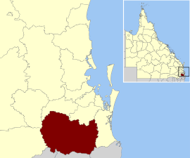
Beaudesert was an electoral district of the Legislative Assembly in the Australian state of Queensland from 1991 to 2017.
The Scenic Rim is a group of forested mountain ranges of the Great Dividing Range, located south of Brisbane agglomeration, straddling the border between south-eastern Queensland and north-eastern New South Wales, Australia. In 2021, the Scenic Rim was named as a Lonely Planet top destination for 2022.
The Shire of Boonah was a local government area in South East Queensland, Australia, about 80 kilometres (50 mi) southwest of Brisbane. The shire covered an area of 1,921.6 square kilometres (741.9 sq mi), and existed from 1880 until its merger with parts of the Shire of Beaudesert and City of Ipswich to form the Scenic Rim Region on 15 March 2008.
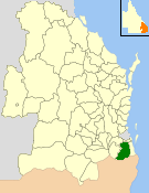
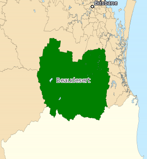
The Shire of Beaudesert was a local government area located in South East Queensland, Australia, stretching from the New South Wales border, along the Gold Coast hinterland to the urban fringes of the cities of Brisbane and Ipswich. The Shire covered an area of 2,854.3 square kilometres (1,102.1 sq mi), and existed from 1879 until its abolition on 15 March 2008, following which it was split between Logan City and the new Scenic Rim Region.
Beechmont is a rural town and locality in the Scenic Rim Region, Queensland, Australia. In the 2016 census, the locality of Beechmont had a population of 842 people.
West Moreton is a region of the Australian state of Queensland, consisting of the entire rural western portion of South East Queensland. It sits inland from both the Brisbane metropolitan area and the Gold Coast and to the east of the Darling Downs. Much of the region lies in the Great Dividing Range. The name appears in the names of many community organisations and is used by the Australian Bureau of Statistics, although is not widely used otherwise due to the prevalence of South East Queensland in planning and other documents.
Maroon is a rural locality in the Scenic Rim Region, Queensland, Australia. In the 2021 census, Maroon had a population of 152 people.
Wonglepong is a rural locality in the Scenic Rim Region, Queensland, Australia. In the 2021 census, Wonglepong had a population of 364 people.
Boyland is a rural locality in the Scenic Rim Region, Queensland, Australia. In the 2021 census, Boyland had a population of 855 people.
Tamborine is a rural town in the Scenic Rim Region and a locality split between the Scenic Rim Region and the City of Logan in Queensland, Australia. In the 2016 census, the locality of Tamborine had a population of 3,950 people.
Palen Creek is a rural locality in the Scenic Rim Region, Queensland, Australia. It borders New South Wales. In the 2021 census, Palen Creek had a population of 368 people.
Running Creek is a rural locality in the Scenic Rim Region, Queensland, Australia. In the 2021 census, Running Creek had a population of 146 people. It borders New South Wales.
Ipswich–Boonah–Rathdowney Road is a continuous 87.8 kilometres (54.6 mi) road route in the Ipswich and Scenic Rim regions of Queensland, Australia. It has two official names, Ipswich–Boonah Road and Boonah–Rathdowney Road. The entire route is signed as State Route 93, and much of it is also part of Tourist Drive 16.
Beaudesert–Boonah–Fassifern Road is a non-continuous 49.9 kilometres (31.0 mi) road route in the Scenic Rim region of Queensland, Australia. It has two official names, Beaudesert–Boonah Road and Boonah–Fassifern Road. The route is signed as State Route 90. These roads are joined by a 6.8 kilometres (4.2 mi) section of Ipswich-Boonah Road. Beaudesert–Boonah Road is a state-controlled regional road, and Boonah–Fassifern Road is also a state-controlled regional road. As part of State Route 90 it provides an alternate route between the Cunningham Highway and the Gold Coast.