School Streets

Last updated

School Streets sign in Lambeth in 2020 Lambeth school streets signage.jpg
School Streets sign in Lambeth in 2020

School Streets is an scheme in the United Kingdom, Germany, Czechia [1] Austria [2] and other countries, to suspend motor traffic access to roads outside schools, during drop-off and pick-up times. [3]

Contents

One of the first schools in the UK to trial the scheme was Gayhurst Community School in Hackney in 2018. As of November 2020, Transport for London has funded 430 new school streets. Legislatively, the scheme is achieved by restricting access to motor vehicles at certain times. [4]

Nearly two-thirds of UK teachers are in favour of roads around schools being closed. [5] A study has shown that School Streets reduce Nitrogen Dioxide levels by up to 23 per cent during morning drop-off. [6]

The scheme aims to: [7]

The programme is supported by Sustrans, a sustainable transport non-profit in the UK. [8]

History

In 2014 a group of Transport Planners from Camden Council went to visit Amsterdam and the surrounding areas to investigate innovations in the local area. A chance conversation with a local transport planner raised the idea of closing the streets outside schools at the start and end of the school day using fire gates.

In The Netherlands it is standard practice to avoid building schools by roads because of the danger caused by roads to children, and because roads by schools encourage more driving to school.

Further investigations highlighted individual examples of schools that had implemented measures like this which appeared to be associated with much better levels of walking or cycling to school - for example, Waingel's Copse School in Reading which banned student drop-off/pickup during the start and end of school day period.

In Camden, the idea evolved into "Healthy School Streets" involving folding bollards in the street being put up by school staff at the start and end of the school day, with road being formally closed by signage, and the staff merely implementing the bollards to enforce it. This initial school delivered significant reductions in driving to school, of the order of 50% in driven trips. [9]

At about the same time, Transport Planners in Edinburgh were working on their own "School Streets" project using signage, rather than folding bollards. [10]

From 2017 onwards, other local authorities, supported in some cases by Transport Planners at Camden providing advisory support, implemented further school streets using similar methodology - or in some cases using more expensive camera enforcement with fines, to allow some residents to be exempt from the road closures.

In March 2018, some parents in Belgium closed the road outside their school instead of going for coffee. They called the movement Filter-Café-Filtre. Over the next two weeks, 42 more schools joined as well. [5] In 2021 some London boroughs have a high proportion of school streets. In Merton, 41% of schools have a school street. [11] They are also being rolled out in Cumbria [12]

Criticism

One limitation of the scheme is that the time restrictions during drop-off and pick-up only do not help to reduce pollution during other times when children are outside, and do not tackle the wider street network which would allow many more children to walk or cycle to school.

However, because once the schemes are implemented these weaknesses become apparent, highlighting the need for wider change, these measures can be a crucial step on the route to better streets. [4]

In 2021, some residents in Ilford, Greater London, opposed the introduction of 10 new School Streets in their borough, Redbridge. They said that the traffic would just move to another area. Instead, they favoured introducing a no stopping zone, which would allow through-traffic to continue. [13] To date, evidence suggests there is no displacement to nearby streets and that overall, motor traffic does decrease overall. [14]

See also

Related Research Articles

<span class="mw-page-title-main">Ilford</span> Human settlement in England

Ilford is a large town in east London, England, 9 miles (14 km) north-east of Charing Cross. Part of the London Borough of Redbridge, Ilford is within the ceremonial county of Greater London. It had a population of 168,168 in 2011, compared to 303,858 for the entire borough.

<span class="mw-page-title-main">Stockwell</span> Human settlement in England

Stockwell is a district located in South West London, part of the London Borough of Lambeth, England. It is situated 2.4 miles (3.9 km) south of Charing Cross.

<span class="mw-page-title-main">Walthamstow</span> Town in East London

Walthamstow is a large town in the London Borough of Waltham Forest, around 7+12 miles (12 km) northeast of Central London.. The town borders Chingford to the north, Snaresbrook and South Woodford to the east, Leyton and Leytonstone to the south, and Tottenham to the west. At the 2011 census, the town had a population of approximately 109,424.

<span class="mw-page-title-main">Camden Town</span> Inner city district of London

Camden Town, often shortened to Camden, is an area in the London Borough of Camden, around 2.5 miles (4.1 km) north-northwest of Charing Cross. Historically in Middlesex, it is identified in the London Plan as one of 34 major centres in Greater London.

<span class="mw-page-title-main">Traffic calming</span> Road design measures that raise the safety of pedestrians and motorists

Traffic calming uses physical design and other measures to improve safety for motorists, pedestrians and cyclists. It has become a tool to combat speeding and other unsafe behaviours of drivers in the neighbourhoods. It aims to encourage safer, more responsible driving and potentially reduce traffic flow. Urban planners and traffic engineers have many strategies for traffic calming, including narrowed roads and speed humps. Such measures are common in Australia and Europe, but less so in North America. Traffic calming is a calque of the German word Verkehrsberuhigung – the term's first published use in English was in 1985 by Carmen Hass-Klau.

<span class="mw-page-title-main">Sustrans</span> British walking and cycling charity

Sustrans is a United Kingdom-based walking, wheeling and cycling charity, and the custodian of the National Cycle Network.

The London Cycling Campaign (LCC) is an independent membership charity lobbying for better conditions for cycling in London. Its vision is to make London "a world-class cycling city". It is one of the largest urban cycling organisations in the world, with over 11,000 members.

<span class="mw-page-title-main">Shared space</span> Roads unsegregated by travel mode

Shared space is an urban design approach that minimises the segregation between modes of road user. This is done by removing features such as kerbs, road surface markings, traffic signs, and traffic lights. Hans Monderman and others have suggested that, by creating a greater sense of uncertainty and making it unclear who has priority, drivers will reduce their speed, in turn reducing the dominance of vehicles, reducing road casualty rates, and improving safety for other road users.

<span class="mw-page-title-main">Road Traffic Regulation Act 1984</span> United Kingdom legislation

The Road Traffic Regulation Act 1984 is an Act of Parliament in the United Kingdom, which provided powers to regulate or restrict traffic on UK roads, in the interest of safety. It superseded some earlier legislation, including the majority of the Road Traffic Regulation Act 1967. The Act is split into 10 parts covering 147 sections, it also includes 14 schedules.

Legible London is a citywide wayfinding system for London, operated by Transport for London (TfL). The system is designed to provide a consistent visual language and wayfinding system across the city, allowing visitors and local residents to easily gain local geographic knowledge regardless of the area they are in. It is the world's largest municipal wayfinding system.

<span class="mw-page-title-main">Cycling in London</span> Overview of cycling in London, England

Cycling is a popular mode of transport and leisure activity within London, the capital city of the United Kingdom. Following a national decline in the 1960s of levels of utility cycling, cycling as a mode of everyday transport within London began a slow regrowth in the 1970s. This continued until the beginning of the 21st century, when levels began to increase significantly—during the period from 2000 to 2012, the number of daily journeys made by bicycle in Greater London doubled to 580,000. The growth in cycling can partly be attributed to the launch in 2010 by Transport for London (TfL) of a cycle hire system throughout the city's centre. By 2013, the scheme was attracting a monthly ridership of approximately 500,000, peaking at a million rides in July of that year. Health impact analyses have shown that London would benefit more from increased cycling and cycling infrastructure than other European cities.

<span class="mw-page-title-main">A400 road (Great Britain)</span> Road in London

The A400 road is an A road in London that runs from Charing Cross to Archway in North London. It passes some of London's most famous landmarks.

<span class="mw-page-title-main">Wandle Trail</span> Trail in London

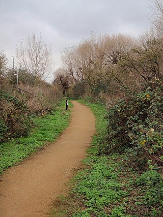
The Wandle Trail is a 12.5-mile (20 km) walking and cycling trail that follows the River Wandle from Croydon to Wandsworth in south-west London.

<span class="mw-page-title-main">Active mobility</span> Unmotorised transport powered by activity

Active mobility, soft mobility, active travel, active transport or active transportation is the transport of people or goods, through non-motorized means, based around human physical activity. The best-known forms of active mobility are walking and cycling, though other modes include running, rowing, skateboarding, kick scooters and roller skates. Due to its prevalence, cycling is sometimes considered separately from the other forms of active mobility.

<span class="mw-page-title-main">Santander Cycles</span> Public bicycle hire scheme in London

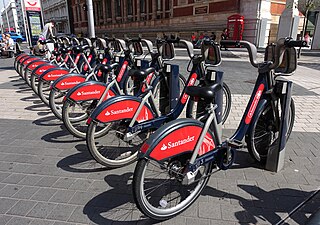
Santander Cycles is a public bicycle hire scheme in London in the United Kingdom. The scheme's bicycles are popularly and colloquially known as Boris Bikes, after Boris Johnson who was Mayor of London when the scheme began operating.

<span class="mw-page-title-main">Cycling infrastructure</span> Facilities for use by cyclists

Cycling infrastructure is all infrastructure cyclists are allowed to use. Bikeways include bike paths, bike lanes, cycle tracks, rail trails and, where permitted, sidewalks. Roads used by motorists are also cycling infrastructure, except where cyclists are barred such as many freeways/motorways. It includes amenities such as bike racks for parking, shelters, service centers and specialized traffic signs and signals. The more cycling infrastructure, the more people get about by bicycle.

<span class="mw-page-title-main">Cycling in the United Kingdom</span>

Cycling in the United Kingdom has a long history, since the earliest days of the bicycle, and after a decline in the mid-20th century has been undergoing a resurgence in recent decades.

<span class="mw-page-title-main">Modal filter</span>

A modal filter, sometimes referred to as a point closure, is a road design that restricts the passage of certain types of vehicle. Modal filtering is often used to help create a low traffic neighbourhood (LTN), where motor traffic is diverted away from residential streets and instead toward feeder roads. Modal filters can be used to achieve filtered permeability within a transport network, and can encourage walking and cycling through more pleasant environments and improved safety.

<span class="mw-page-title-main">Low Traffic Neighbourhood</span> Urban planning to restrict through traffic

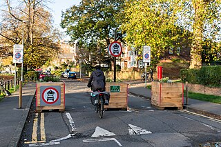
In the United Kingdom, a Low Traffic Neighbourhood(LTN) is a plan implemented to reduce motorised through-traffic in residential areas through filtered permeability and traffic calming. Many LTNs were introduced in spring 2020, although the same principles had been in use in London since the 1970s.

References

  1. "With the new school year, Prague is seeing a boom in school zones. Where have they been established?". Městem na kole (in Czech). 17 September 2023. Retrieved 22 September 2023.
  2. "Schulstraße". Wien zu Fuß (in German). Retrieved 22 September 2023.
  3. "School Streets Initiative - All the information you need". School Streets Initiative. Retrieved 29 April 2021.
  4. 1 2 Slawson, Nicola (23 November 2020). "What is a School Street and how do they work?". www.standard.co.uk. Retrieved 29 April 2021.
  5. 1 2 "Pollutionwatch: the fight for clean air at the school gates". The Guardian. 23 May 2019. Retrieved 14 May 2021.
  6. "New studies show School Streets improve air quality". Bloomberg Philanthropies. Retrieved 14 May 2021.
  7. "Frequently asked questions about School Streets". Wandsworth Borough Council. Retrieved 29 April 2021.
  8. "Sustrans School Streets". Sustrans. Retrieved 29 April 2021.
  9. https://www.camden.gov.uk/documents/20142/0/Healthy+School+Streets+Initial+Report+Final.pdf/7f0497ec-2d4d-e25b-7072-2a600e5832f2
  10. "School Streets Project- Proposed Experimental Traffic Regulation Order - Prohibition of Vehicular Traffic (During School Travel Periods) - City of Edinburgh Council - Citizen Space".
  11. "Merton named as leading London borough for school streets". Wimbledon Guardian. 14 July 2021.
  12. "Cars could be banned from outside a west Cumbrian school as part of experimental traffic regulation". ITV News. 7 July 2021.
  13. "Ilford residents' group oppose one of 10 new 'School Streets' schemes". East London and West Essex Guardian Series. Retrieved 14 May 2021.
  14. "School street closures could improve amount of walking, cycling and wheeling to school, study shows". Napier.