Related Research Articles

Gary is a city in Lake County, Indiana, United States. The city has been historically dominated by major industrial activity and is home to U.S. Steel's Gary Works, the largest steel mill complex in North America. Gary is located along the southern shore of Lake Michigan about 25 miles (40 km) southeast of downtown Chicago, Illinois. The city is adjacent to the Indiana Dunes National Park, and is within the Chicago metropolitan area.

Clay County is a county located in the U.S. state of Indiana. As of 2020, the population was 26,466. The county seat is Brazil.
Lake County is a county located in the U.S. state of Indiana. In 2020, its population was 498,700, making it Indiana's second-most populous county. The county seat is Crown Point. The county is part of Northwest Indiana and the Chicago metropolitan area, and contains a mix of urban, suburban and rural areas. It is bordered on the north by Lake Michigan and contains a portion of the Indiana Dunes. It includes Marktown, Clayton Mark's planned worker community in East Chicago.
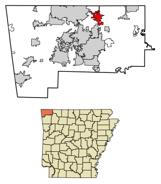
Pea Ridge is a city in Benton County, Arkansas, United States. The name Pea Ridge is derived from a combination of the physical location of the original settlement of the town, across the crest of an Ozark Mountains ridge, and for the hog peanuts or turkey peas that had been originally cultivated by Native American tribes centuries before European settlement, which later helped to provide basic subsistence once those pioneer settlers arrived.
Chicago Ridge is a village in Cook County, Illinois, United States. Per the 2020 census, the population was 14,433.

New Albany is a city in Floyd County, Indiana, United States, situated along the Ohio River, opposite Louisville, Kentucky. The population was 37,841 as of the 2020 census. The city is the county seat of Floyd County. It is bounded by I-265 to the north and the Ohio River to the south, and is considered part of the Louisville, Kentucky Metropolitan Statistical Area. The mayor of New Albany is Jeff Gahan, a Democrat; he was re-elected in 2019.

Hammond is a city in Lake County, Indiana, United States. It is part of the Chicago metropolitan area, and the only city in Indiana to border Chicago. First settled in the mid-19th century, it is one of the oldest cities of northern Lake County. As of the 2020 United States census, it is also the largest in population. The 2020 population was 77,879, replacing Gary as the most populous city in Lake County. From north to south, Hammond runs from Lake Michigan down to the Little Calumet River; from east to west along its southern border, it runs from the Illinois state line to Cline Avenue. The city is traversed by numerous railroads and expressways, including the South Shore Line, Borman Expressway, and Indiana Toll Road. Notable local landmarks include the parkland around Wolf Lake and the Horseshoe Hammond riverboat casino. Part of the Rust Belt, Hammond has been industrial almost from its inception, but is also home to a Purdue University campus and numerous historic districts that showcase the residential and commercial architecture of the early 20th century.
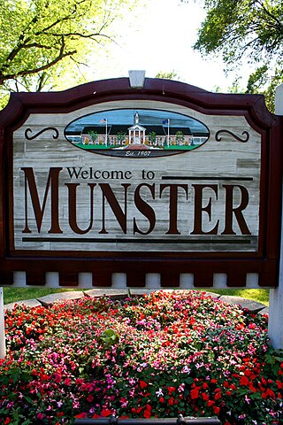
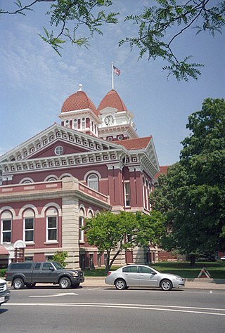
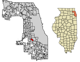
Munster is a suburban town in North Township, Lake County, Indiana, United States. It is in the Chicago metropolitan area, approximately 30 miles (48 km) southeast of the Chicago Loop, and shares municipal boundaries with Hammond to the north, Highland to the east, Dyer and Schererville to the south, and Lansing and Lynwood directly west of the Illinois border. Its population was 23,603 at the 2010 US Census.

Roxborough is a neighborhood in the Northwest section of the city of Philadelphia, Pennsylvania, United States. It is bordered to the southwest, along the Schuylkill River, by the neighborhood of Manayunk, along the northeast by the Wissahickon Creek section of Fairmount Park, and to the southeast by the neighborhood of East Falls. Beyond Roxborough to the northwest is Montgomery County. Roxborough's ZIP code is 19128. Most of Roxborough is in Philadelphia's 21st Ward.

Michigan Avenue is a north-south street in Chicago that runs at 100 east on the Chicago grid. Despite being 100 east, if you take into consideration that Wabash and Michigan avenues are evenly placed between State Street and Indiana Avenue, Michigan Avenue is actually closer to 166 or 167 east, to be precise. The northern end of the street is at Lake Shore Drive on the shore of Lake Michigan in the Gold Coast Historic District. The street's southern terminus is at Sibley Boulevard in the southern suburb of Dolton, but like many other Chicago streets, it exists in several disjointed segments.

Six Corners is a shopping district in the Portage Park neighborhood of Chicago's Northwest Side.

Milan Township is one of twenty townships in Allen County, Indiana, United States. Milan Township is located in east central Allen County, with the Maumee River meandering across the township. As of the 2010 census, its population was 3,749. The township is highly rural, with only 1,137 houses in the 2010 census. Many of the residents of Milan Township are Swiss Amish who mostly speak a Low Alemannic Alsatian dialect. Milan township is generally demarcated by Schwartz Road to the west, Notestine Road to the north, Sampson Road to the east, and Gar Creek Road to the south.
WMTH-FM, located in Park Ridge, Illinois, was among the first FM high school radio stations in the United States when it was licensed in 1959. Established by the Student Council at Maine Township High School, now Maine East High School, the station went on the air during December 1959. The station became known as "The Voice of Maine Township".
Hamilton High School is a public high school in Hamilton, Ohio. It is the only high school in the Hamilton City School District. It was the school in which then-President George W. Bush signed the No Child Left Behind Act on January 8, 2002.

Palos Township is one of 29 townships in Cook County, Illinois. As of the 2020 census, its population was 56,836, with its most populous municipality being Palos Hills. The vast majority of the township's population resides in its eastern half; the half west of La Grange Road consists mainly of facilities in the Cook County Forest Preserves. In 1850 the small town of Trenton, Illinois changed its name to Palos; this recommendation was made by M.S. Powell, the local postmaster, whose ancestor supposedly sailed with Christopher Columbus from Palos de la Frontera. When it incorporated as a village in 1914, Palos officially became Palos Park. The neighboring communities of Palos Hills and Palos Heights incorporated at later points. All three municipalities lie completely or substantially within Palos Township.

Center Township is one of eight townships in Vanderburgh County, Indiana, United States. As of the 2010 census, its population was 39,007 and it contained 16,306 housing units.

Gary Metro Center is a multimodal commuter hub operated by the Gary Public Transportation Corporation. It was built in 1984 as an elevated replacement of the previously ground-level Broadway Street Station.
Washington Local School District is a school district in Northwest Ohio. The school district serves students who live in Lucas County. Washington Local Schools is located in Toledo, Ohio, and students who attend must be residents living within the school district boundaries. The superintendent is Dr. Kadee Anstadt.

The Southern Indiana Career & Technical Center is a high school-level institution that provides advanced education to meet the demand in the areas of agriculture, business and marketing, family and consumer sciences, health careers, and trade and industry arts to the students in Indiana's Area Career & Technical District #46 (ACTD-46) consisting of nine school district and corporations in Gibson, Posey, Spencer, Vanderburgh and Warrick Counties in Southwestern Indiana. 90.7 FM WPSR, which used to broadcast from Central High School, now broadcasts from the center.

Green Park, an unincorporated village located in northeastern Tyrone Township, Perry County, Pennsylvania, United States, sits at the intersection of state routes 233 and 274. The name was given to a local land tract by James Baxter in the late 1700s and made popular as an unofficial moniker for mid- to late-1800s picnic and camp meeting grounds located at the upper end of Stambaugh Farm Run. The town serves as Perry County's midpoint between the Conococheague Mountain in the west and the Susquehanna River to the east.
References
| | This Indiana school-related article is a stub. You can help Wikipedia by expanding it. |