
The Black Forest is a large forested mountain range in the state of Baden-Württemberg in southwest Germany. It is bounded by the Rhine valley to the west and south.

Furtwangen im Schwarzwald is a small city located in the Black Forest region of southwestern Germany. Together with Villingen-Schwenningen, Furtwangen is part of the district of Schwarzwald-Baar.
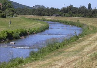
The Rench is a right-hand tributary of the Rhine in the Ortenau. It rises on the southern edge of the Northern Black Forest at Kniebis near Bad Griesbach im Schwarzwald. The source farthest from the mouth is that of the Schöngrundbächle which rises at a height of around 915 m above NN in the parish of Zuflucht near the old youth hostel. After flowing through its steep mountainside klinge it is joined by other streams to form, first, the Old (Alter), then the Wild Rench, which first becomes the Rench below Bad Griesbach. The Rench runs in a prominent southerly arc through the Central Black Forest and crosses the hilly region of Ortenau with its orchards and vineyards before breaking out into the Rhine Plain. After just under 57 km it discharges, together with the Mühlbach, into the Rhine at 314.7 km between Helmlingen (Rheinau) and Lichtenau.

The Hochfirst Ski Jump is a ski jumping hill located in Titisee-Neustadt in the state of Baden-Württemberg in Germany. The ski jump is named after the mountain Hochfirst in the Black Forest. It is the biggest natural ski jumping hill. This means that in contrast to many other ski jumping facilities, rather than an artificial tower, the natural gradient of the mountain slope was used for construction.

Bad Peterstal-Griesbach is a municipality in the district of Ortenau in Baden-Württemberg in Germany.
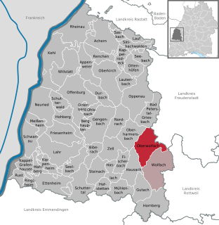
Oberwolfach is a town in the district of Ortenau in Baden-Württemberg, Germany. It is the site of the Mathematical Research Institute of Oberwolfach, or Mathematisches Forschungsinstitut Oberwolfach.

The Schwarzwaldhochstraße or Black Forest High Road is the oldest and one of the best known themed drives in Germany. It is a part of the B 500 federal highway and leads over 60 km from Baden-Baden to Freudenstadt.
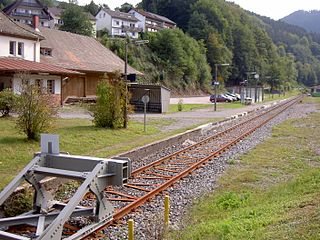
The Rench Valley Railway is a 29.1 kilometre long branch line from Appenweier to Bad Griesbach (Schwarzwald), that mainly follows the valley of the River Rench in the Black Forest with maximum inclines of 1:99.
The Baar is a plateau that lies 600 to 900 metres above sea level in southwest Germany. It is bordered by the southeastern edge of the Black Forest to the west, the southwestern part of the Swabian Alb known as the Heuberg to the east, and the Randen mountain to the south.

The Kniebis is a 960-metre-high mountain ridge in the Black Forest and the name of a village to the south which is a dispersed settlement. The Kniebis mountain rises in the state of Baden-Württemberg, Germany.

The Rohrhardsberg is a mountain in the Central Black Forest in southern Germany. At 1,152.1 metres (3,780 ft) above sea level, it is the northernmost summit of the elongated, north-south oriented Farnberg Plateau that has several high points over 1,150 metres. The mountain is situated near Elzach in the state of Baden-Württemberg.

The Alb is a river in the Northern Black Forest in Germany. It is a tributary of the Rhine, and flows through the cities of Karlsruhe, Ettlingen and Bad Herrenalb.

A schanze is, according to the specialist terminology of German fortification construction, an independent fieldwork, that is frequently used in the construction of temporary field fortifications. The word is German and has no direct English equivalent, although the word sconce is derived from Dutch schans, which is cognate to the German word.

The Southern Black Forest Nature Park is located in Baden-Württemberg in Germany and covers an area of 394,000 hectares. As of 2018, it is Germany's largest nature park.

The Baroque fortifications in the Black Forest, also called Baroque Schanzen (Barockschanzen) or Black Forest lines (Schwarzwaldlinien), are historical, military earthworks, known as schanzen, that were built in the Black Forest in what is now Germany. They were built in the 17th century to defend the Margraviate of Baden from French invasion. Together with their adjoining defensive lines, the Black Forest fortifications formed a defensive system over 200 kilometres long that ran from north to south.

The Hohwart is a mountain near the village of Breitnau in the Black Forest in the German state of Baden-Wurttemberg. It is 1,123 metres high.

There are numerous prehistorical and early historical ringworks and fortification ramparts in Central Europe that have erroneously, usually colloquially, been given the name Schwedenschanze, which means "Swedish redoubt", a schanze being a hastily erected, military fieldwork.

The Bundesstraße 462 is a German Bundesstraße or federal road. It runs from the Upper Rhine Plain near Rastatt for about 114 kilometres (71 mi) through the northern Black Forest to Rottweil. The section from Rastatt to Freudenstadt, which runs through the Murg valley to Baiersbronn, has been known since the 1960s as the Black Forest Valleys Road (Schwarzwald-Tälerstraße) and, along with the B 500, is one of the tourist routes in the Black Forest. Both roads meet in Freudenstadt. In 2001 the section from Rastatt to Gaggenau was widened into a dual carriageway as far as Schloss Bad Rotenfels (Landesakademie) and a further widening to the centre of Gaggenau is planned. In 1997, the road through Gernsbach was relieved by the building of the 1,527-metre-long Gernsbach Tunnel.

The Rench Valley Trail is a 98-kilometre-long 'prestige hiking trail (Prädikatswanderweg) in the Central/North Black Forest Nature Park in Germany. It runs in five stages around the Rench valley with its start and finish near Oberkirch.
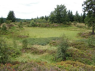
The Röschenschanze is a former schanze in Bad Peterstal-Griesbach in the Black Forest in Southern Germany.


