Scollard Formation

Last updated
Scollard Formation
Stratigraphic range: Maastrichtian-Danian
~70–65  Ma
O
S
D
C
P
T
J
K
Pg
N
Scollard.jpg
Scollard Formation exposed along the Red Deer River, Alberta. The Tyrannosaurus rex skeleton on display at the Royal Tyrrell Museum of Palaeontology was excavated in the center of image.
Type Geological formation
Unit of Edmonton Group
Sub-unitsArdley coal zone
Underlies Paskapoo Formation
Overlies Battle Formation
ThicknessUp to 300 metres (980 ft) [1]
Lithology
Primary Sandstone, siltstone, shale
Other Coal, bentonite
Location
Coordinates 51°56′19″N112°55′37″W / 51.93861°N 112.92694°W / 51.93861; -112.92694 (Scollard Formation)
Approximate paleocoordinates 62°48′N86°12′W / 62.8°N 86.2°W / 62.8; -86.2
RegionFlag of Alberta.svg  Alberta
CountryFlag of Canada (Pantone).svg  Canada
Extent Western Canada Sedimentary Basin
Type section
Named forScollard Canyon at Dry Island Buffalo Jump Provincial Park
Named byIrish, E.J.W [2]
Year defined1970
Canada relief map 2.svg
Green-orange pog.svg
Scollard Formation (Canada)
Canada Alberta relief location map - transverse mercator proj.svg
Green-orange pog.svg
Scollard Formation (Alberta)

The Scollard Formation is an Upper Cretaceous to lower Palaeocene stratigraphic unit of the Western Canada Sedimentary Basin in southwestern Alberta. [1] [3] Its deposition spanned the time interval from latest Cretaceous to early Paleocene, and it includes sediments that were deposited before, during, and after the Cretaceous-Paleogene (K-Pg) extinction event. It is significant for its fossil record, and it includes the economically important coal deposits of the Ardley coal zone.

Contents

Lithology

The Scollard Formation consists primarily of sandstones and siltstones, interbedded with mudstones and, in the upper portion, coal seams, as well as minor amounts of bentonite. [1] The sediments were eroded from the Canadian Cordillera, and were transported eastward by river systems and deposited in fluvial channel and floodplain environments.

Stratigraphy

The Scollard is usually classified as the uppermost formation of the Edmonton Group, although some early workers included it in the overlying Paskapoo Formation. [4] It is subdivided into an upper, coal-bearing member that consists of the Ardley coal zone, and a lower member that lacks significant coal. [1] Neither member has been formally named.

Age

The K-Pg boundary in the Scollard Formation. The coals are earliest Paleocene in age, lighter shales below are Maastrichtian. The lighter rock at the very base of the dark coals represents the K-Pg boundary. Scollard Formation K-Pg boundary by Nick Longrich.jpg
The K-Pg boundary in the Scollard Formation. The coals are earliest Paleocene in age, lighter shales below are Maastrichtian. The lighter rock at the very base of the dark coals represents the K-Pg boundary.

The K-Pg boundary occurs at the base of the lowermost seam of Ardley coal zone, based on dinosaurian and microfloral evidence, [5] as well as the presence of the terminal Cretaceous iridium anomaly. [6] The upper member is therefore of early Danian age, while the lower member is of latest Maastrichtian age.

Distribution

The Scollard Formation is present in the subsurface throughout much of southwestern Alberta, [7] and it outcrops extensively along the banks of the Red Deer River in the area of Trochu. [8] Both the upper and lower members thin from west to east. Thicknesses for each member range from more than 300 metres (980 ft) near the foothills of the Canadian Rockies to less than 100 metres (330 ft) near the outcrops in south-central Alberta. [1]

Relationship to other units

The Scollard Formation rests disconformably on the Late Cretaceous Battle Formation in the southwestern Alberta plains, on the Wapiti Formation in the northwestern plains, and on the Brazeau Formation in the foothills. It is unconformably overlain by the Paskapoo Formation, and where the Paskapoo has been removed by erosion, the Scollard is exposed at surface or covered by Quaternary sediments.

The Scollard grades into the Willow Creek Formation in the southern Alberta plains and the Coalspur Formation in the Alberta foothills. The Ardley coal zone in the upper portion is equivalent to the lower part of the Coalspur coal zone of the Coalspur Formation, [9] and is correlated with the lower part of the Ravenscrag Formation of southern Saskatchewan, which is also coal bearing. [10] The Late Cretaceous member is equivalent in age to the Frenchman Formation of Saskatchewan, the Hell Creek Formation of Montana, and the Lance Formation of Wyoming . [1]

Coal deposits

Metasequoia occidentalis, upper Scollard Formation, central Alberta Metasequoia occidentalis.jpg
Metasequoia occidentalis , upper Scollard Formation, central Alberta

The coal seams of the Ardley coal zone attain thicknesses in excess of 7 metres (20 ft) in some areas. The zone is present at shallow depths and, in places, exposed at surface, along a trend between Red Deer and Edmonton. The coal is typically of sub-bituminous B to C rank, although more deeply buried Scollard coals farther to the west reach high-volatile bituminous rank. The Ardley coal has been mined in the Red Deer area, and is currently being mined west of Edmonton to fuel mine-mouth electric power generating stations. [11]

Paleontology

The Scollard Formation preserves the remains of vertebrates, especially dinosaurs and, rarely, mammals, as well as a wide range of plant fossils. The Scollard strata span the K-Pg boundary, therefore the lower member of the Scollard provides a record of the last of the dinosaurs, while the upper member records the dawn of the Age of Mammals after the K-Pg extinction event.

Flora

Plant fossils from the upper, early Paleocene member of the Scollard Formation include species of the ferns Botrychium , Woodwardia and Azolla ; the conifers Metasequoia and Glyptostrobus ; the monocot Limnobiophyllum (a relative of duckweeds); and the dicots Cercidiphyllum and Platanus . [12] [13]

Vertebrates

Crocodylian Albertosuchus , acanthomorph fish Lindoeichthys and unnamed esocid fish are known. [14] [15] [16]

Theropods

Ornithomimus remains have been unearthed here. [17] Two caenagnathid taxa, a large-bodied one similar to Caenagnathus and a small-bodied one similar to Leptorhynchos have been found. [18]

Theropods
GenusSpeciesLocationStratigraphic positionMaterialDescriptionImages

cf. Dromaeosaurus [19]

Indeterminate [19]

Teeth

A dromaeosaurid

Dromaeosaurus Dromaeosaurus Restoration.png
Dromaeosaurus
Saurornitholestes Saurornitholestes digging Burrows wahweap.jpg
Saurornitholestes
Troodon Troodon (cropped).jpg
Troodon
Tyrannosaurus Tyrannosaurus-rex-Profile-steveoc86.png
Tyrannosaurus

cf. Paronychodon [20]

Indeterminate [19]

cf. Richardoestesia [21]

cf. R. gilmorei [22]

cf. R. isosceles [23]

cf. Saurornitholestes [19]

cf. S. langstoni [19]

Troodon [24]

Indeterminate [19]

A Single Tooth

Tyrannosaurus [19]

T. rex [19]

Partial Skeleton

Ornithischians

Torosaurus remains have also been unearthed in this region. [25] Edmontonia remains have also been unearthed here and in the nearby areas. [17]

Color key
Taxon Reclassified taxonTaxon falsely reported as presentDubious taxon or junior synonym Ichnotaxon Ootaxon Morphotaxon
Notes
Uncertain or tentative taxa are in small text; crossed out taxa are discredited.
Ornithischians
GenusSpeciesLocationStratigraphic positionMaterialDescriptionImages

Ankylosaurus [19]

A magniventris [19]

Complete skull, both mandibles, ribs, caudal vertebrae, tail club, both humeri, left ischium, left femur, right fibula, and osteoderms.An ankylosaurine ankylosaurid also found in the Lance, Frenchman, Ferris and Hell Creek Formations.
Ankylosaurus Ankylosaurus skull AMNH.jpg
Ankylosaurus
Edmontosaurus Anatotitan BW.jpg
Edmontosaurus
Leptoceratops Leptoceratops BW.jpg
Leptoceratops
Pachycephalosaurus Pachycephalosaurus Reconstruction.jpg
Pachycephalosaurus
Thescelosaurus Thescelosaurus filamented.jpg
Thescelosaurus
Triceratops Triceratops by Tom Patker.png
Triceratops

Edmontosaurus [19]

E. annectens [19]

Leptoceratops [19]

L. gracilis [19]

Partial Skull

cf. Pachycephalosaurus [19]

P. wyomingensis [19]

Domed Parietal

Thescelosaurus [19]

T. edmontonensis [19]

Complete Skeleton

Referred to Thescelosaurus sp. [26]

Triceratops [19]

indeterminate [19]

Skull

See also

Related Research Articles

<span class="mw-page-title-main">Horseshoe Canyon Formation</span> Geological formation in Canada

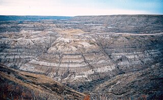
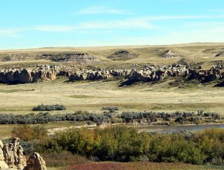
The Horseshoe Canyon Formation is a stratigraphic unit of the Western Canada Sedimentary Basin in southwestern Alberta. It takes its name from Horseshoe Canyon, an area of badlands near Drumheller.

The Frenchman Formation is stratigraphic unit of Late Cretaceous age in the Western Canada Sedimentary Basin. It is present in southern Saskatchewan and the Cypress Hills of southeastern Alberta. The formation was defined by G.M. Furnival in 1942 from observations of outcrops along the Frenchman River, between Ravenscrag and Highway 37. It contains the youngest of dinosaur genera, much like the Hell Creek Formation in the United States.

<span class="mw-page-title-main">Bearpaw Formation</span> Geologic formation in North America

The Bearpaw Formation, also called the Bearpaw Shale, is a geologic formation of Late Cretaceous (Campanian) age. It outcrops in the U.S. state of Montana, as well as the Canadian provinces of Alberta and Saskatchewan, and was named for the Bear Paw Mountains in Montana. It includes a wide range of marine fossils, as well as the remains of a few dinosaurs. It is known for its fossil ammonites, some of which are mined in Alberta to produce the organic gemstone ammolite.

The Milk River Formation is a sandstone-dominated stratigraphic unit of the Western Canada Sedimentary Basin in southern Alberta, Canada. It was deposited in near-shore to coastal environments during Late Cretaceous time. Based on uranium-lead dating, palynology and stratigraphic relationships, deposition occurred between ~84.1 and 83.6 Ma.

<span class="mw-page-title-main">Foremost Formation</span> Geologic formation in Alberta, Canada

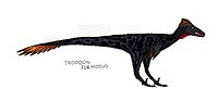
The Foremost Formation is a stratigraphic unit of Late Cretaceous (Campanian) age that underlies much of southern Alberta, Canada. It was named for outcrops in Chin Coulee near the town of Foremost and is known primarily for its dinosaur remains and other fossils.

The Wapiti Formation is a geological formation of the Western Canada Sedimentary Basin in northwestern Alberta, and northeastern British Columbia, Canada. Its deposition spanned the time interval from the lower Campanian through to the upper Maastrichtian, between approximately 80 and 68 Ma. It was named by G.M. Dawson in 1881, presumably for exposures along the lower part of the Wapiti River and downstream along the Smoky River in Alberta.

<span class="mw-page-title-main">St. Mary River Formation</span> Geologic formation in western Canada

The St. Mary River Formation is a geologic formation of Late Cretaceous age of the Western Canada Sedimentary Basin in southwestern Alberta and northwesternmost Montana. It was first described from outcrops along the St. Mary River by George Mercer Dawson in 1883, and it takes its name from the river.

The Willow Creek Formation is a stratigraphic unit of Late Cretaceous to Early Paleocene age in the Western Canada Sedimentary Basin of southwestern Alberta. It was first described by George Mercer Dawson in 1883 along the Willow Creek, a tributary of the Oldman River. Williams and Dyer defined the type section in 1930 at the mouth of Willow Creek, east of Fort Macleod.

Gething Formation is a stratigraphic unit of Lower Cretaceous (Aptian) age in the Western Canada Sedimentary Basin. It is present in northeastern British Columbia and western Alberta, and includes economically important coal deposits.

<span class="mw-page-title-main">Paskapoo Formation</span> Stratigraphic unit in Western Canada

The Paskapoo Formation is a stratigraphic unit of Middle to Late Paleocene age in the Western Canada Sedimentary Basin. The Paskapoo underlies much of southwestern Alberta, and takes the name from the Blindman River. It was first described from outcrops along that river, near its confluence with the Red Deer River north of the city of Red Deer, by Joseph Tyrrell in 1887. It is important for its freshwater aquifers, its coal resources, and its fossil record, as well as having been the source of sandstone for the construction of fire-resistant buildings in Calgary during the early 1900s.

The Mist Mountain Formation is a geologic formation of latest Jurassic to earliest Cretaceous age in the Western Canada Sedimentary Basin that is present in the southern and central Canadian Rockies. It was named for outcrops along the western spur of Mist Mountain in Alberta by D.W. Gibson in 1979. The Mist Mountain Formation contains economically important coal seams that have been mined in southeastern British Columbia and southwestern Alberta.

<span class="mw-page-title-main">Edmonton Group</span> Stratigraphic unit in central Alberta, Canada

Within the earth science of geology, the Edmonton Group is a Late Cretaceous to early Paleocene stratigraphic unit of the Western Canada Sedimentary Basin in the central Alberta plains. It was first described as the Edmonton Formation by Joseph Burr Tyrrell in 1887 based on outcrops along the North Saskatchewan River in and near the city of Edmonton. E.J.W. Irish later elevated the formation to group status and it was subdivided into four separate formations. In ascending order, they are the Horseshoe Canyon, Whitemud, Battle and Scollard Formations. The Cretaceous-Paleogene boundary occurs within the Scollard Formation, based on dinosaurian and microfloral evidence, as well as the presence of the terminal Cretaceous iridium anomaly.

The Ravenscrag Formation is a stratigraphic unit of early Paleocene age in the Western Canada Sedimentary Basin. It was named for the settlement of Ravenscrag, Saskatchewan, and was first described from outcrops at Ravenscrag Butte near the Frenchman River by N.B. Davis in 1918.

The Porcupine Hills Formation is a stratigraphic unit of middle to late Paleocene age in the Western Canada Sedimentary Basin. It takes its name from the Porcupine Hills of southwestern Alberta, and was first described in outcrop by George Mercer Dawson in 1883.

The Minnes Group, originally named the Minnes Formation, is a geologic unit of latest Jurassic to earliest Cretaceous age in the Western Canada Sedimentary Basin. It is present in the northern foothills of the Canadian Rockies and the adjacent plains in northeastern British Columbia and west-central Alberta. Its strata include natural gas reservoirs and minor coal deposits. Fossil dinosaur tracks have been described from one of its formations.

The Coalspur Formation is an Upper Cretaceous to lower Palaeocene stratigraphic unit of the Western Canada Sedimentary Basin in the foothills of southwestern Alberta. Its deposition spanned the time interval from latest Cretaceous (Maastrichtian) to early Palaeocene, and it includes sediments that were deposited before, during, and after the Cretaceous-Paleogene (K-Pg) extinction event. It includes the economically important coal deposits of the Coalspur Coal Zone, as well as nonmarine plant and animal fossils.

The Battle Formation is a geologic formation of Late Cretaceous (Maastrichtian) age in the Western Canada Sedimentary Basin. It is present throughout much of the central Alberta plains, where it is an important stratigraphic marker in the nonmarine Upper Cretaceous sequence. It was formally named by G.M. Furnival in 1942 and given formation status by E.J.W. Irish in 1970.

The Kootenay Group, originally called the Kootenay Formation, is a geologic unit of latest Jurassic to earliest Cretaceous age in the Western Canada Sedimentary Basin that is present in the southern and central Canadian Rockies and foothills. It includes economically important deposits of high-rank bituminous and semi-anthracite coal, as well as plant fossils and dinosaur trackways.

The Gorman Creek Formation is a geologic formation of Early Cretaceous (Valanginian) age in the Western Canada Sedimentary Basin that consists primarily of nonmarine sediments. It is present in the northern foothills of the Canadian Rockies and the adjacent plains in northeastern British Columbia. Plant fossils and dinosaur tracks have been described from its strata.

The geology of Alberta encompasses parts of the Canadian Rockies and thick sedimentary sequences, bearing coal, oil and natural gas, atop complex Precambrian crystalline basement rock.

References

  1. 1 2 3 4 5 6 Mossop, G.D. and Shetsen, I., (compilers), Canadian Society of Petroleum Geologists (1994). "The Geological Atlas of the Western Canada Sedimentary Basin, Chapter 24: Upper Cretaceous and Tertiary strata of the Western Canada Sedimentary Basin". Archived from the original on 2013-07-21. Retrieved 2013-08-01.{{cite web}}: CS1 maint: multiple names: authors list (link)
  2. Irish, E.J.W., 1970. The Edmonton Group of south-central Alberta; Canadian Society of Petroleum Geologists (CSPG), Bulletin of Canadian Petroleum Geology, vol. 18, no. 2 (June), pp. 125-155.
  3. Lexicon of Canadian Geological Units. "Scollard Formation". Archived from the original on 2013-02-21. Retrieved 2009-02-06.
  4. Hamblin, A.P. (2004). "Paskapoo-Porcupine Hills Formation in western Alberta: Synthesis of regional geology and resource potential. Geological Survey of Canada, Open File 4679" . Retrieved 2013-08-01.
  5. Lerbekmo, J.F., Singh, C., Jarzen, D.M., and Russel, D.A. 1979. The Cretaceous-Tertiary boundary in south-central Alberta - a revision based on dinosaurian and microfloral evidence. Canadian Journal of Earth Science, 16: 325-330.
  6. Lerbekmo, J.F. and St. Louis, R.M. 1985. The terminal Cretaceous iridium anomaly in the Red Deer Valley, Alberta. Canadian Journal of Earth Science, 23: 120-124.
  7. Prior, G. J., Hathaway, B., Glombick, P.M., Pana, D.I., Banks, C.J., Hay, D.C., Schneider, C.L., Grobe, M., Elgr, R., and Weiss, J.A. (2013). "Bedrock Geology of Alberta. Alberta Geological Survey, Map 600". Archived from the original on 2013-09-25. Retrieved 2013-08-13.{{cite web}}: CS1 maint: multiple names: authors list (link)
  8. "Introduction," Ryan and Russel (2001); page 279.
  9. Langenberg, C.W., Berhane, H., Sweet, A.R., Marchioni, D. and Heamann, L.M. 2007. Regional correlations of the Ardley coal zone, Alberta. Alberta Geological Survey, Earth Sciences Report 2007-5, 21 p.
  10. Alberta Geological Survey, 2013. "Alberta Table of Formations; Alberta Energy Regulator" (PDF). Retrieved 2016-06-20.{{cite web}}: CS1 maint: numeric names: authors list (link)
  11. Mossop, G.D. and Shetsen, I., (compilers), Canadian Society of Petroleum Geologists (1994). "The Geological Atlas of the Western Canada Sedimentary Basin, Chapter 33: Coal Resources of the Western Canada Sedimentary Basin". Archived from the original on 2013-09-30. Retrieved 2013-08-01.{{cite web}}: CS1 maint: multiple names: authors list (link)
  12. Chandrasekharam, A., 1974. Megafossil flora from the Genesee locality, Alberta, Canada. Palaeontographica, Abt. A, Band 147, 41 p.
  13. Christophel, D.C., 1976. Fossil floras from the Smoky Tower locality, Alberta, Canada. Palaeontographica, Abt. B, Band 157, 43 p.
  14. Wu, Xiao-Chun; Brinkman, Donald B. (2015). "A new crocodylian (Eusuchia) from the uppermost Cretaceous of Alberta, Canada". Canadian Journal of Earth Sciences. 52 (8): 590–607. doi:10.1139/cjes-2014-0133. ISSN   0008-4077.
  15. Murray, Alison M.; Brinkman, Donald B.; Newbrey, Michael G.; Neuman, Andrew G. (2020). "Earliest North American articulated freshwater acanthomorph fish (Teleostei: Percopsiformes) from Upper Cretaceous deposits of Alberta, Canada". Geological Magazine. 157 (7): 1087–1096. doi:10.1017/S0016756819001328. ISSN   0016-7568. S2CID   212927875.
  16. Brinkman, Don; Van Loon, Lisa L.; Banerjee, Neil R. (2021). "3D Non-Destructive Identification of Fossil Fish from the Late Cretaceous of Alberta, Canada using Synchrotron Micro Computed Tomography". Microscopy Today. 29 (2): 26–31. doi:10.1017/s155192952100047x. ISSN   1551-9295. S2CID   232249820.
  17. 1 2 Carpenter, Kenneth; Young, D. Bruce (2002). "Late Cretaceous dinosaurs from the Denver Basin, Colorado". Rocky Mountain Geology. 37 (2): 237–254. Bibcode:2002RMGeo..37..237C. doi:10.2113/11 via GeoScienceWorld.
  18. Voris, Jared T.; Zelenitsky, Darla K.; Therrien, François (2023-09-11). "Caenagnathids (Theropoda, Oviraptorosauria) from the uppermost Maastrichtian of the Scollard Formation of Alberta, Canada". Cretaceous Research. 153: 105708. doi:10.1016/j.cretres.2023.105708. ISSN   0195-6671. S2CID   261779584.
  19. 1 2 3 4 5 6 7 8 9 10 11 12 13 14 15 16 17 18 19 20 "Dinosaur distribution (Late Cretaceous; North America; Yukon Territory, Canada)." In: Weishampel et al. Page 578.
  20. Listed as "cf. Paronychodon sp." in Weishampel et al. Page 578.
  21. Referred to by the obsolete spelling "Ricardoestesia" in Weishampel et al. Page 578.
  22. Listed as "cf. Ricardoestesia gilmorei" in Weishampel et al. Page 578.
  23. Listed as "cf. Ricardoestesia isosceles" in Weishampel et al. Page 578.
  24. Listed as "cf. Troodon sp." in Weishampel et al. Page 578.
  25. Mallon, Jordan C; Holmes, Robert B; Bamforth, Emily L; Schumann, Dirk (2022). "The record of Torosaurus (Ornithischia: Ceratopsidae) in Canada and its taxonomic implications". Zoological Journal of the Linnean Society. 195 (1): 157–171. doi: 10.1093/zoolinnean/zlab120 . ISSN   0024-4082.
  26. Boyd, Clint A.; Brown, Caleb M.; Scheetz, Rodney D.; and Clarke, Julia A. (2009). "Taxonomic revision of the basal neornithischian taxa Thescelosaurus and Bugenasaura". Journal of Vertebrate Paleontology 29 (3): 758–770. doi:10.1671/039.029.0328.

Bibliography