
Oglala Lakota County is a county in southwestern South Dakota, United States. The population was 13,672 at the 2020 census. Oglala Lakota County does not have a functioning county seat; Hot Springs in neighboring Fall River County serves as its administrative center. The county was created as a part of the Dakota Territory in 1875, although it remains unorganized. Its largest community is Pine Ridge.

Minnehaha County is a county on the eastern border of the state of South Dakota. As of the 2020 census, the population was 197,214, making it the state's most populous county. It contains over 20% of the state's population. Its county seat is Sioux Falls, South Dakota's largest city. The county was created in 1862 and organized in 1868. Its name was derived from the Sioux word Mnihaha, meaning "rapid water," or "waterfall".

Scott County is a county in the U.S. state of Minnesota. As of the 2020 census, the population was 150,928. Its county seat is Shakopee. Shakopee is also the largest city in Scott County, the twenty-third-largest city in Minnesota, and the sixteenth-largest Twin Cities suburb. The county was organized in 1853 and named in honor of General Winfield Scott. Scott County is part of the Minneapolis-St. Paul-Bloomington, MN-WI Metropolitan Statistical Area. It is a member of the Metropolitan Council, and shares many of the council's concerns about responsible growth management, advocating for progressive development concepts such as clustering, open-space design, and the preservation of open space and rural/agricultural land.

Dakota County is the third-most populous county in the U.S. state of Minnesota, located in the east central portion of the state. As of the 2020 census, the population was 439,882. The population of Dakota County was estimated to be 442,038 in 2021. The county seat is Hastings. Dakota County is named for the Dakota Sioux tribal bands who inhabited the area. The name is recorded as "Dahkotah" in the United States Census records until 1851. Dakota County is included in the Minneapolis–St. Paul–Bloomington, MN–WI Metropolitan Statistical Area, the sixteenth largest metropolitan area in the United States with about 3.64 million residents. The largest city in Dakota County is the city of Lakeville, the eleventh-largest city in Minnesota and sixth-largest Twin Cities suburb. The county is bordered by the Minnesota and Mississippi Rivers on the north, and the state of Wisconsin on the east.
Spring Lake may refer to:
Prior Lake is an exurban city 20 miles (32 km) southwest of Minneapolis seated next to Savage and Shakopee in Scott County in the state of Minnesota. Surrounding the shores of Lower and Upper Prior Lake, the city lies south of the Minnesota River in an area known as RiverSouth and establishes the urban fringe of the south-southwest portion of Minneapolis-St. Paul, the sixteenth largest metropolitan area in the United States. The population of Prior Lake was 22,796 at the 2010 census.
Watertown is a city in and the county seat of Codington County, South Dakota, United States. Watertown is home to the Redlin Art Center which houses many of the original art works produced by Terry Redlin, one of America's most popular wildlife artists. Watertown is located between Pelican Lake and Lake Kampeska, from which Redlin derived inspiration for his artwork.

Madison is a city in Lake County, South Dakota, United States. The population was 6,191 at the 2020 census. It is the county seat of Lake County and is home to Dakota State University.
Lake Township may refer to:

U.S. Route 83 (US 83) is a major north–south United States Numbered Highway that extends 1,885 miles (3,034 km) in the central United States. Only four other north–south routes are longer: US 1, US 41, US 59, and US 87, while US 83 follows a straighter north-south path than all of these. Nearly half of its mileage is in the state of Texas. The highway's northern terminus is north of Westhope, North Dakota, at the Canadian border, where it continues as Manitoba Highway 83 (PTH 83). The southern terminus is at the Veterans International Bridge in Brownsville, Texas. Together, US 83 and PTH 83 form a continuously numbered north-south highway with a combined distance of 3,450 kilometres (2,140 mi).

UTC−05:00 is an identifier for a time offset from UTC of −05:00. In North America, it is observed in the Eastern Time Zone during standard time, and in the Central Time Zone during the other eight months. The western Caribbean uses it year round.
Spring Lake Township may refer to:

The Little Minnesota River is a 71.4-mile-long (114.9 km) headwaters tributary of the Minnesota River in northeastern South Dakota and west-central Minnesota in the United States. Via the Minnesota River, it is part of the Mississippi River watershed.

Sylvan Lake is a lake located in Custer State Park, in the Black Hills of South Dakota, United States. It was created in 1891 when Theodore Reder built a dam across Sunday Gulch Creek. The lake area offers picnic places, rock climbing, small rental boats, swimming, and hiking trails. It is also popular as a starting point for excursions to Black Elk Peak and The Needles. A hotel was operated on the shore of the lake in the early 20th century.
The Drift Prairie is a geographic region of North Dakota and South Dakota.
The Dakota are a Native American tribe and First Nations band government in North America. They compose two of the three main subcultures of the Sioux people, and are typically divided into the Eastern Dakota and the Western Dakota.

Silver City is an unincorporated community in Pennington County, South Dakota, United States, outside Rapid City. It lies at the head of Pactola Lake on Rapid Creek, and is about 5 miles west of U.S. Route 385 via a paved county road. It is not tracked by the U.S. Census Bureau.
The Department of the Northwest was an U.S. Army Department created September 6, 1862 to put down the Sioux uprising in Minnesota. Major General John Pope was made commander of the Department. At the end of the Civil War the Department was redesignated the Department of Dakota. Immediately upon arriving in St. Paul General Pope sent letters to the Governors of Iowa and Wisconsin for additional troops to assist the 5th Minnesota Infantry Regiment. From Iowa he got the 27th Iowa Infantry Regiment and from Wisconsin he received the 25th Wisconsin Infantry Regiment. Both quickly crossed the border to assist with the uprising. The 25th Wisconsin was in Minnesota three months and the 27th Iowa was there a month before both headed south. After they departed, the Minnesota District would be garrisoned by Minnesota units: 5th, 6th, 7th, 8th, 9th, 10th Infantry Regiments, 1st and 2nd Minnesota Cavalry Regiments plus Minnesota Independent Cavalry Battalion as well as the 3rd Minnesota Light Artillery Battery. In 1864 companies of the 30th Wisconsin Infantry Regiment would see service in the Minnesota and Dakota Districts too.

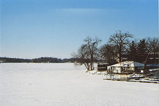
Lake Herman State Park is a South Dakota state park in Lake County, South Dakota in the United States. The park is open for year-round recreation including camping, swimming, fishing, hiking and boating on the 1,350-acre Lake Herman. There are 72 campsites which feature electric hook-ups and 4 cabins.
Roy Lake State Park is a South Dakota state park in Marshall County, South Dakota in the United States. The park is divided in two sections on Roy Lake, and is open for year-round recreation including camping, beaches, swimming, fishing, hiking and boating. The Roy Lake Resort & Lodge is located in the park. Boat ramps are available and visitors can rent boats from the resort.

