Searsport, Maine

Last updated

Searsport, Maine
Searsport Maine.JPG
Street in Searsport. The Penobscot Marine Museum is across the street.
Waldo County Maine Incorporated Areas Searsport Town Highlighted.png
Location of the town of Searsport (in yellow) in Waldo County and the state of Maine.
Coordinates: 44°27′30″N68°55′27″W / 44.45833°N 68.92417°W / 44.45833; -68.92417
CountryUnited States
State Maine
County Waldo
Incorporated1845
Area
[1]
  Total42.53 sq mi (110.15 km2)
  Land28.65 sq mi (74.20 km2)
  Water13.88 sq mi (35.95 km2)
Elevation
236 ft (72 m)
Population
 (2020)
  Total2,649
  Density92/sq mi (35.7/km2)
Time zone UTC-5 (Eastern (EST))
  Summer (DST) UTC-4 (EDT)
ZIP code
04974
Area code 207
FIPS code 23-66635
GNIS feature ID0582716
Website www.searsport.maine.gov

Searsport is an incorporated town and deep water seaport located at the confluence of the Penobscot River estuary and the Penobscot Bay immediately northwest of Sears Island and Cape Jellison in Waldo County, Maine, United States. [2] The population was 2,649 at the 2020 census. [3] Searsport includes the village of North Searsport. The town is known as "the home of the famous sea captains" and the "Antique Capital of Maine".[ citation needed ]

Contents

History

Searsport was settled in the 1760s and incorporated on February 13, 1845, from portions of Prospect and Belfast. In 1747, when fire destroyed the Province House in Boston, General Samuel Waldo advocated, unsuccessfully, that the capital of Massachusetts be moved to Searsport, which was part of the Waldo Patent he had purchased about 1720. [4] It was named after David Sears of Boston after he agreed to grant a large sum of money towards the town's founding. Searsport is noted for its rich maritime history. During the 19th-century the port had 17 shipyards and built 200 ships, while supplying fully one-tenth of the United States' merchant marine deep water captains, per square mile more than any other community in the country. [4] [5] The Penobscot Marine Museum faithfully recalls this heritage.[ citation needed ]

Port facilities

Searsport is Maine's second largest deep water port and is ideally located from the point of view of railroad, wood products and other development interests.[ citation needed ] Indeed, the town became the Penobscot Bay shipping terminus for the Northern Maine Seaport Railroad, a line opened in 1905 by the Bangor and Aroostook Railroad, which sent potatoes, timber and other products from here by boat, and loaded coal for use by its locomotives, without having to arrange rates with the Maine Central Railroad. [6] Searsport harbor is an excellent sheltered anchorage, covering an area of roughly 2 by 3 miles (3 by 5 km), with a controlling depth of 40 feet (12 m) at mean low water and an average tidal fluctuation of 10 feet (3.0 m). The railroad pier is 800 feet (240 m) long and 100 feet (30 m) wide, with belt conveyors to handle bagged cargo to and from four warehouses. Tracks running along either side of the pier can hold 24 railcars on the west side and twelve cars on the east side. Sprague pier is 614 feet (187 m) long, with an adjacent berth 850-foot (260 m) in length. Berths adjacent to the piers are dredged to a mean low water depth of 32 feet (9.8 m) and are connected to a turning basin by channels 500 feet (150 m) wide. The Searsport railway yard can hold 700 cars. [7] The port facilities at Searsport were a preferred loading point for ammunition during World War II. [8]

Geography

According to the United States Census Bureau, the town has a total area of 42.53 square miles (110.15 km2), of which 28.65 square miles (74.20 km2) is land and 13.88 square miles (35.95 km2) is water. [1] Situated on Penobscot Bay, Searport is drained by Long Cove Brook and Mill Brook. It includes Sears Island, which is 940 acres (3.8 km2) in area.

The town is crossed by U. S. Route 1 and Maine State Route 3. It borders the towns of Prospect and Stockton Springs to the northeast, Belfast to the southwest, Swanville to the northwest and Frankfort to the north.

Demographics

Historical population
CensusPop.Note
1850 2,208
1860 2,53214.7%
1870 2,282−9.9%
1880 2,3221.8%
1890 1,693−27.1%
1900 1,349−20.3%
1910 1,4447.0%
1920 1,373−4.9%
1930 1,4143.0%
1940 1,319−6.7%
1950 1,45710.5%
1960 1,83826.1%
1970 1,9516.1%
1980 2,30918.3%
1990 2,60212.7%
2000 2,6411.5%
2010 2,615−1.0%
2020 2,6491.3%
U.S. Decennial Census [9]

2010 census

At the 2010 census, [10] there were 2,615 people, 1,186 households and 715 families residing in the town. The population density was 91.3 per square mile (35.3/km2). There were 1,510 housing units at an average density of 52.7 per square mile (20.3/km2). The racial make-up of the town was 97.2% White, 0.5% African American, 0.8% Native American, 0.1% Asian, 0.2% Pacific Islander and 1.2% from two or more races. Hispanic or Latino of any race were 0.9% of the population.

There were 1,186 households, of which 24.5% had children under the age of 18 living with them, 43.5% were married couples living together, 12.0% had a female householder with no husband present, 4.8% had a male householder with no wife present and 39.7% were non-families. 32.3% of all households were made up of individuals and 15.5% had someone living alone who was 65 years of age or older. The average household size was 2.20 and the average family size was 2.73.

The median age was 46.9 years. 19% of residents were under the age of 18, 6.5% were between the ages of 18 and 24, 22.2% were from 25 to 44, 33.5% were from 45 to 64 and 19% were 65 years of age or older. The sex make-up of the town was 47.7% male and 52.3% female.

2000 census

At the 2000 census, [11] there were 2,641 people, 1,130 households and 732 families residing in the town. The population density was 92.4 per square mile (35.7/km2). There were 1,370 housing units at an average density of 47.9 per square mile (18.5/km2). The racial make-up of the town was 98.07% White, 0.27% Black or African American, 0.72% Native American, 0.08% from other races and 0.87% from two or more races. Hispanic or Latino of any race were 0.19% of the population.

There were 1,130 households, of which 27.6% had children under the age of 18 living with them, 51.2% were married couples living together, 10.0% had a female householder with no husband present and 35.2% were non-families. 28.7% of all households were made up of individuals and 13.4% had someone living alone who was 65 years of age or older. The average household size was 2.34 and the average family size was 2.86.

23.3%Of the population were under the age of 18, 7.2% from 18 to 24, 25.7% from 25 to 44, 28.6% from 45 to 64 and 15.2% were 65 years of age or older. The median age was 41 years. For every 100 females, there were 91.4 males. For every 100 females age 18 and over, there were 87.1 males.

The median household income was $31,288 and the median family income was $38,333. Males had a median income of $31,629 and females $23,221. The per capita income was $18,883. About 11.3% of families and 13.4% of the population were below the poverty line, including 19.0% of those under age 18 and 11.0% of those age 65 or over.

Government

Searsport's government is organized around a town meeting system and is characteristic of a New England town, with an annual town meeting held every March and special town meetings held at various times during the year. A five-member board of selectmen (with its members serving three-year terms) is elected on the Tuesday before the annual meeting and it, along with the town manager, run the town's daily affairs, including overseeing town water, sewage treatment, law enforcement, fire protection, emergency medical service, recreational programs and a library. They may not pass a budget or most ordinances without town approval at the annual or a special town meeting. The town does not have a mayor, but the board of selectmen does choose a chair who is responsible for running its meetings and who is considered the chief executive officer for the town.[ citation needed ]

Notable people

Sites of interest

Related Research Articles

<span class="mw-page-title-main">Penobscot County, Maine</span> County in Maine, United States

Penobscot County is a county in the U.S. state of Maine, named for the Penobscot people in Wabanakik. As of the 2020 census, the population was 152,199, making it the third-most-populous county in Maine. Its county seat is Bangor. The county was established on February 15, 1816, from part of Hancock County when the area was still part of Massachusetts. Penobscot County is home to the University of Maine.

<span class="mw-page-title-main">Aroostook County, Maine</span> County in Maine, United States

Aroostook County is a county in the U.S. state of Maine along the Canada–United States border. As of the 2020 census, the population was 67,105. Its county seat is Houlton, with offices in Caribou and Fort Kent.

<span class="mw-page-title-main">Ludlow, Maine</span> Town in the state of Maine, United States

Ludlow is a town in Aroostook County, Maine, United States. The population was 434 at the 2020 census.

<span class="mw-page-title-main">Verona Island, Maine</span> Town in Maine, United States

Verona Island is a town located on an island of the same name in the Penobscot River in Hancock County, Maine, United States. The population was 507 at the 2020 census.

<span class="mw-page-title-main">Charleston, Maine</span> Town in the state of Maine, United States

Charleston is a town in Penobscot County, Maine, United States. It is part of the Bangor Metropolitan Statistical Area. The population was 1,558 at the 2020 census. Charleston includes the village of West Charleston and is home to the Higgins Classical Institute, a Christian school.

<span class="mw-page-title-main">Corinna, Maine</span> Town in the state of Maine, United States

Corinna is a town in Penobscot County, Maine, United States. The population was 2,221 at the 2020 census. It is part of the Bangor metropolitan statistical area. The village of Corinna is in the southern part of the town.

Corinth is a town in Penobscot County, Maine, United States. The population was 2,900 at the 2020 census.

Orrington is a town on the Penobscot River estuary in Penobscot County, Maine, United States. The population was 3,812 at the 2020 census.

<span class="mw-page-title-main">Veazie, Maine</span> Town in the state of Maine, United States

Veazie is a town in Penobscot County, Maine, United States. The population was 1,814 at the 2020 census. The town is named after General Samuel Veazie, an early lumber baron and railroad operator. Veazie was originally part of Bangor, using Penobscot River water power to operate sawmills. It became a separate town in 1853 because Gen. Veazie, its wealthiest citizen, thought Bangor's property taxes were too high.

<span class="mw-page-title-main">Brownville, Maine</span> Town in the state of Maine, United States

Brownville is a town in Piscataquis County, Maine, United States. The population was 1,139 at the 2020 census. The town includes the villages of Brownville, Knight's Landing and Brownville Junction, near which passes the 100-Mile Wilderness of the Appalachian Trail.

<span class="mw-page-title-main">Belfast, Maine</span> City in Maine, United States

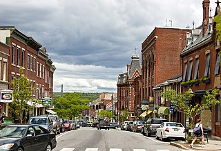
Belfast is a city in Waldo County, Maine, United States. As of the 2020 census, the city population was 6,938. Located at the mouth of the Passagassawakeag River estuary on Belfast Bay and Penobscot Bay. Belfast is the county seat of Waldo County. Its seaport has a wealth of antique architecture in several historic districts, and remains popular with tourists.

<span class="mw-page-title-main">Frankfort, Maine</span> Town in the state of Maine, United States

Frankfort is a town on the Penobscot River estuary in Waldo County, Maine, United States. The population was 1,231 at the 2020 census.

<span class="mw-page-title-main">Prospect, Maine</span> Town in the state of Maine, United States

Prospect is a town in Waldo County, Maine, United States. The population was 698 at the 2020 census.

<span class="mw-page-title-main">Stockton Springs, Maine</span> Town in the state of Maine, United States

Stockton Springs is a town in Waldo County, Maine, United States. The population was 1,533 at the 2020 census. Stockton Springs is home to Fort Point State Park and Fort Point Light, both located on Fort Point, a peninsula on Cape Jellison.

<span class="mw-page-title-main">Swanville, Maine</span> Town in the state of Maine, United States

Swanville is a town in Waldo County, Maine, United States. The population was 1,377 at the 2020 census.

<span class="mw-page-title-main">Millinocket, Maine</span> Town in the state of Maine, United States

Millinocket is a town in Penobscot County, Maine, United States. The population was 4,114 at the 2020 census.

<span class="mw-page-title-main">Fort Fairfield, Maine</span> Town in the state of Maine, United States

Fort Fairfield is a town in Aroostook County, eastern Maine, United States, located along the Canada–US border. The population was 3,322 at the 2020 census.

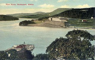
Bucksport is a census-designated place (CDP) in the town of Bucksport in Hancock County, Maine, United States. The population was 2,885 at the 2010 census, down from 2,970 at the 2000 census.

<span class="mw-page-title-main">Milo, Maine</span> Town in the state of Maine, United States

Milo is a town in Piscataquis County, Maine, United States. The population was 2,251 at the 2020 census. Milo includes the village of Derby. The town sits in the valley of the Piscataquis, Sebec and Pleasant Rivers in the foothills of the Longfellow Mountains and is the gateway to many pristine hunting, fishing, hiking, boating, and other outdoor tourist locations such as Schoodic, Seboeis, and Sebec Lakes, Mount Katahdin and its backcountry in Baxter State Park and the Katahdin Woods and Waters National Monument, Katahdin Iron Works and Gulf Hagas.

<span class="mw-page-title-main">Winterport, Maine</span> Town in the state of Maine, United States

Winterport is a town in Waldo County, Maine, United States. The population was 3,817 at the 2020 census. The Winterport Historic District, extending several blocks along Main Street, was listed on the National Register of Historic Places in 1975.

References

  1. 1 2 "US Gazetteer files 2010". United States Census Bureau . Retrieved December 16, 2012.
  2. "The Penobscot River Estuary". Penobscot River Synthesis /The University of Maine. Archived from the original on March 30, 2013.
    - Haefner, Paul A. (1967). "Hydrography of the Penobscot River (Maine) Estuary" (PDF). J. Fish. Res. Bd. Canada. 24 (7): 1553–1571. doi:10.1139/f67-128.[ dead link ]
    - The Maine Atlas and Gazetteer (13th ed.). DeLorme Mapping Company. 1988. ISBN   0-89933-035-5. map 15
  3. "Census - Geography Profile: Searsport town, Waldo County, Maine" . Retrieved January 16, 2022.
  4. 1 2 Coolidge, Austin J.; John B. Mansfield (1859). A History and Description of New England. Boston, Massachusetts: A.J. Coolidge. p.  299 via Internet Archive.
  5. Vickery, Oliver (1979). Harbor Heritage: Tales of the Harbor Area of Los Angeles, California. Morgan Press/Farag Associates.
  6. Schafer, Mike (2000). More Classic American Railroads. Osceola, WI: MBI Publishing Co. p. 9. ISBN   978-0-7603-0758-8. OCLC   44089438.
  7. Strout, W. Jerome (1966). 75 Years The Bangor and Aroostook. Bangor, Maine: Bangor and Aroostook Railroad. pp. 38–39.
  8. Angier, Jerry; Cleaves, Herb (1986). Bangor and Aroostook, the Maine Railroad. Littleton, MA: Flying Yankee Enterprises. pp. 87–89. ISBN   0-9615574-2-7.
  9. "Census of Population and Housing". Census.gov. Retrieved June 4, 2015.
  10. "U.S. Census website". United States Census Bureau . Retrieved December 16, 2012.
  11. "U.S. Census website". United States Census Bureau . Retrieved January 31, 2008.
  12. "Nevada Governor Roswell Keyes Colcord". National Governors Association. Retrieved September 26, 2012.[ dead link ]
  13. "GARLAND, Peter Adams, (1923–2005)". Biographical Directory of the United States Congress. Retrieved September 26, 2012.
  14. Goad, Meredith (April 26, 2016). "Maine native Matthew Kenney plans new restaurant in Belfast". PortlandPress Herald. Retrieved November 1, 2023.
  15. "SMART, Ephraim Knight, (1813–1872)". Biographical Directory of the United States Congress. Retrieved September 26, 2012.
  16. "STEVENS, Frederick Clement, (1861–1923)". Biographical Directory of the United States Congress. Retrieved September 26, 2012.


44°27′30″N68°55′27″W / 44.45833°N 68.92417°W / 44.45833; -68.92417