
Indialantic is a town in Brevard County, Florida. It is part of the Palm Bay–Melbourne–Titusville, Florida Metropolitan Statistical Area. The town's population was 3,010 at the 2020 United States Census, up from 2,720 at the 2010 census.

Sebastian Inlet, located in Sebastian Inlet State Park in Brevard County, Florida and Indian River County, Florida, offers surfing and fishing opportunities. It is off State Road A1A just 12 miles north of Vero Beach. There are annual surf tournaments, professional and amateur. Visitors fish there, particularly for Snook and Redfish.

State Road A1A (SR A1A) is a major north–south Florida State Road consisting of seven separate sections running a total of 338.752 miles (545.168 km) along the Atlantic Ocean, from Key West at the southern tip of Florida, to Fernandina Beach, just south of Georgia on Amelia Island. It is the main road through most oceanfront towns. Part of SR A1A is designated the A1A Scenic and Historic Coastal Byway, a National Scenic Byway. A portion of SR A1A that passes through Volusia County is designated the Ormond Scenic Loop and Trail, a Florida Scenic Highway. It is also called the Indian River Lagoon Scenic Highway from State Road 510 at Wabasso Beach to U.S. Route 1 in Cocoa. SR A1A is famous worldwide as a center of beach culture in the United States, a scenic coastal route through most Atlantic coastal cities and beach towns, including the unique tropical coral islands of the Florida Keys. SR A1A also serves as a major thoroughfare through Miami Beach and other south Florida coastal cities.
The Broadway Bridge is a segmental bridge that spans the Halifax River and Intracoastal Waterway in downtown Daytona Beach, Florida, carrying U.S. Route 92.

The Melbourne Causeway is located entirely within Brevard County, Florida in the United States. It is composed of three bridges and connects the municipalities of Melbourne and Indialantic across the Indian River Lagoon in Brevard County. The causeway is part of U.S. 192, whose eastern terminus is located approximately 2 miles (3.2 km) east of the bridge, at SR A1A. East of the bridge, the road is known locally as Fifth Avenue. On the western side, the road continues through downtown Melbourne as Strawbridge Avenue. Each July 4, the bridge is closed for a fireworks show.

State Road 404 (SR 404), the Pineda Causeway, is an east–west divided highway currently running from Interstate 95 (I-95) to SR A1A at Patrick Space Force Base, Florida, US. It was opened as a toll road in 1971 and classified as a state road two years later. The tolls were removed in 1990. It was named after Pineda, a former village east of Suntree on U.S. Route 1 (US 1). With interchanges at US 1 (SR 5), South Tropical Trail, and South Patrick Drive (SR 513), the Pineda Causeway is the primary access for Patrick Space Force Base and the southern end of Merritt Island. From US 1 to the eastern terminus, it is part of the Indian River Lagoon Scenic Highway system.

The Merritt Island Causeway, mostly in Merritt Island, connects Cocoa, Merritt Island, Florida, and Cocoa Beach, Florida. The causeway transits the Willard Peebles bridge over the Banana River Lagoon. In the 1960s, SR A1A was routed over the eastern causeway from present day SR 520 and SR A1A, to the present day intersection of SR 520 and SR 3 on Merritt Island. The eastern section is known as the Cocoa Beach Causeway.

The Eau Gallie Causeway connects Eau Gallie, Florida, with SR A1A near Indian Harbour Beach, across the Indian River Lagoon. Located entirely within the Melbourne city limits, the causeway consists of a main bridge crossing over the Intracoastal Waterway and a relief bridge. The bridge is a key link in SR 518, Eau Gallie Boulevard, of which the causeway is a part.

State Road 732 (SR 732) comprises two segments of a state highway in the Jensen Beach, Florida vicinity. The western 2.2-mile-long (3.5 km) segment is a part of Jensen Beach Boulevard between U.S. Route 1 (US 1) and County Road 723 (CR 723) and CR 707A. The eastern 1.9-mile-long (3.1 km) segment consists of Causeway Boulevard and the Jensen Beach Causeway over the Indian River Lagoon and runs between CR 707 and SR A1A.

U.S. Highway 1 (US 1) in Florida runs 545 miles (877 km) along the state's east coast from Key West to its crossing of the St. Marys River into Georgia north of Boulogne and south of Folkston. US 1 was designated through Florida when the U.S. Numbered Highway System was established in 1926. With the exception of Monroe County, the highway runs through the easternmost tier of counties in the state, connecting numerous towns and cities along its route, including nine county seats. The road is maintained by the Florida Department of Transportation (FDOT).
The Indian River Lagoon Scenic Highway is a 130-mile-long (210 km) scenic byway located in Florida. The highway is a collection of several roads, running north and south along either side of the Indian River Lagoon, connected by other roads running over the Lagoon.
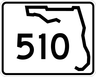
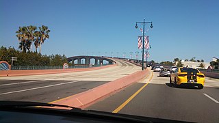
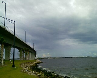
State Road 510 is a 2.606-mile-long (4.194 km) state highway in northern Indian River County, extending from U.S. Route 1 in Wabasso to SR A1A in Orchid. The route acts primarily as a bridge across the Indian River, known as the Wabasso Causeway, the northernmost crossing of the Intracoastal Waterway in Indian River County. The entire highway is on the Indian River Lagoon Scenic Highway.

Pennsylvania Route 652 is a 10.559-mile-long (16.993 km) east–west state highway located in the northeast Pennsylvania county of Wayne. The western terminus of the route is at U.S. Route 6 in the Texas Township community of Indian Orchard. The highways heads to the northeast, and reaches the eastern terminus at the New York-Pennsylvania border in Damascus Township, where PA 652 crosses the Narrowsburg–Darbytown Bridge over the Delaware River and into New York, continuing as New York State Route 52 and County Route 24 in Sullivan County.

Hutchinson Island consists of two barrier islands on the coast of Martin, St. Lucie, and Indian River counties, in Florida. The two islands are separated by the Fort Pierce Inlet and are known as "North Hutchinson Island" and "South Hutchinson Island".
North Hutchinson Island is a coastal barrier island in Indian River and St. Lucie counties on the east coast of Florida in the United States. The island is adjacent to the Atlantic Ocean and is separated from the mainland on the west by the Indian River Lagoon. The portion of the island in Indian River County is known as Orchid Island.

The 17th Street Bridge is a fixed concrete bridge that spans the Indian River intracoastal waterway in Indian River County, Florida. The bridge, started in 1977, was constructed by Gulf Contracting Inc, FL and was completed in 1979.

The ʻŌpaekaʻa Road Bridge is a steel truss bridge listed on the National Register of Historic Places located along ʻŌpaekaʻa Road in the Wailua Homesteads neighborhood of Kapaʻa, on the island of Kauaʻi, in the state of Hawaii, United States. The one-lane bridge spans ʻŌpaekaʻa Stream. With steel beams forged in 1890 by the Alexander Findlay & Company in Motherwell, Scotland, this is touted as possibly the only British-built bridge located in the United States.

The Indian River Inlet Bridge is a cable-stayed bridge located in Sussex County, Delaware, in the United States. It carries four lanes of Delaware Route 1 over the Indian River Inlet between the Indian River Bay and the Atlantic Ocean. The bridge also carries Delaware Bicycle Route 1 across the inlet. The bridge is within Delaware Seashore State Park between Dewey Beach and Bethany Beach. The Indian River Inlet Bridge is maintained by the Delaware Department of Transportation (DelDOT). The bridge is 2,600 feet (790 m) long and 107.66 feet (32.81 m) wide, with a span of 950 feet (290 m) and overhead clearance of 45 feet (14 m).
The South Lake Worth Inlet, also known as the Boynton Inlet, is an artificial cut through a barrier beach connecting the south end of the Lake Worth Lagoon in Palm Beach County, Florida with the Atlantic Ocean. The inlet is 130 feet (40 m) wide and 6 to 12 feet deep.
The Fore River Bridge spans the Weymouth Fore River between Quincy and Weymouth, Massachusetts. The total length of the bridge including the approaches is 2,216 feet (675 m).

