Seibert, Colorado

Last updated
Seibert, Colorado
Seibert elevator.jpg
Overview from the south
Kit Carson County Colorado Incorporated and Unincorporated areas Seibert Highlighted 0869040.svg
Location of Seibert in Kit Carson County, Colorado.
Coordinates: 39°17′58″N102°52′13″W / 39.29944°N 102.87028°W / 39.29944; -102.87028
Country Flag of the United States.svg  United States
State Flag of Colorado.svg  Colorado
County [1] Kit Carson
Incorporated June 21, 1917 [2]
Government
  Type Statutory Town [1]
Area
[3]
  Total0.34 sq mi (0.89 km2)
  Land0.34 sq mi (0.89 km2)
  Water0.00 sq mi (0.00 km2)
Elevation
[4]
4,711 ft (1,436 m)
Population
 (2020) [5]
  Total172
  Density510/sq mi (190/km2)
Time zone UTC-7 (MST)
  Summer (DST) UTC-6 (MDT)
ZIP code [6]
80834
Area code 970
FIPS code 08-69040
GNIS feature ID 0195118

Seibert is a statutory town in Kit Carson County, Colorado, United States. The population was 172 at the 2020 census. [5]

Contents

History

A post office called Seibert has been in operation since 1888. [7] The community was named after Henry Seibert, a railroad agent. [8]

Geography

Seibert is located at 39°17′58″N102°52′13″W / 39.29944°N 102.87028°W / 39.29944; -102.87028 (39.299456, -102.870204). [9]

According to the United States Census Bureau, the town has a total area of 0.3 square miles (0.78 km2), all of it land.

Climate

Climate data for Seibert, Colorado, 1991–2020 normals, extremes 20042022
MonthJanFebMarAprMayJunJulAugSepOctNovDecYear
Record high °F (°C)76
(24)
80
(27)
83
(28)
88
(31)
93
(34)
107
(42)
105
(41)
100
(38)
97
(36)
90
(32)
80
(27)
73
(23)
107
(42)
Mean maximum °F (°C)66.3
(19.1)
66.5
(19.2)
76.5
(24.7)
82.9
(28.3)
88.9
(31.6)
98.1
(36.7)
98.9
(37.2)
96.5
(35.8)
93.3
(34.1)
84.9
(29.4)
75.0
(23.9)
66.3
(19.1)
100.0
(37.8)
Average high °F (°C)42.5
(5.8)
44.8
(7.1)
55.0
(12.8)
62.5
(16.9)
71.4
(21.9)
83.0
(28.3)
89.1
(31.7)
85.0
(29.4)
78.4
(25.8)
65.0
(18.3)
51.7
(10.9)
42.6
(5.9)
64.3
(17.9)
Daily mean °F (°C)28.8
(−1.8)
30.6
(−0.8)
39.9
(4.4)
47.3
(8.5)
57.1
(13.9)
67.9
(19.9)
74.0
(23.3)
71.3
(21.8)
63.6
(17.6)
50.8
(10.4)
38.1
(3.4)
29.5
(−1.4)
49.9
(9.9)
Average low °F (°C)15.2
(−9.3)
16.3
(−8.7)
24.9
(−3.9)
32.1
(0.1)
42.9
(6.1)
52.8
(11.6)
59.0
(15.0)
57.5
(14.2)
48.8
(9.3)
36.6
(2.6)
24.4
(−4.2)
16.3
(−8.7)
35.6
(2.0)
Mean minimum °F (°C)−3.3
(−19.6)
−2.1
(−18.9)
8.9
(−12.8)
19.0
(−7.2)
29.9
(−1.2)
42.8
(6.0)
50.9
(10.5)
49.6
(9.8)
35.5
(1.9)
18.9
(−7.3)
10.3
(−12.1)
−3.8
(−19.9)
−10.1
(−23.4)
Record low °F (°C)−17
(−27)
−24
(−31)
−10
(−23)
6
(−14)
23
(−5)
36
(2)
46
(8)
45
(7)
27
(−3)
1
(−17)
−13
(−25)
−18
(−28)
−24
(−31)
Average precipitation inches (mm)0.28
(7.1)
0.49
(12)
1.01
(26)
1.44
(37)
2.69
(68)
2.05
(52)
2.64
(67)
2.70
(69)
1.10
(28)
1.22
(31)
0.39
(9.9)
0.60
(15)
16.61
(422)
Average snowfall inches (cm)3.8
(9.7)
4.2
(11)
5.8
(15)
4.6
(12)
0.8
(2.0)
0.0
(0.0)
0.0
(0.0)
0.0
(0.0)
0.0
(0.0)
2.1
(5.3)
2.4
(6.1)
5.9
(15)
29.6
(76.1)
Average precipitation days (≥ 0.01 in)2.93.03.95.28.05.07.47.24.44.22.83.557.5
Average snowy days (≥ 0.1 in)2.62.52.62.00.20.00.00.00.00.72.03.215.8
Source 1: NOAA [10]
Source 2: National Weather Service (mean maxima/minima 20062020) [11]

Demographics

Historical population
CensusPop.Note
1920 311
1930 273−12.2%
1940 249−8.8%
1950 34639.0%
1960 210−39.3%
1970 192−8.6%
1980 180−6.2%
1990 1810.6%
2000 180−0.6%
2010 1810.6%
2020 172−5.0%
U.S. Decennial Census

See also

Related Research Articles

<span class="mw-page-title-main">Pritchett, Colorado</span> Town in Colorado, United States

Pritchett is a Statutory Town in Baca County, Colorado, United States. The population was 112 at the 2020 census.

<span class="mw-page-title-main">Vilas, Colorado</span> Town in Colorado, United States

Vilas is a statutory town located in Baca County, Colorado, United States. The population was 98 at the 2020 census.

<span class="mw-page-title-main">Walsh, Colorado</span> Town in Colorado, United States

Walsh is a Statutory Town in Baca County, Colorado, United States. The population was 543 at the 2020 census.

<span class="mw-page-title-main">Sugar City, Colorado</span> Town in Colorado, United States

Sugar City is a Statutory Town in Crowley County, Colorado, United States. The population was 259 at the 2020 census.

<span class="mw-page-title-main">Walden, Colorado</span> Town in Jackson County, Colorado, United States

Walden is the Statutory Town that is the county seat, the most populous community, and the only incorporated municipality in Jackson County, Colorado, United States. It is situated in the center of a large open valley called North Park. People from Walden and the surrounding area refer to themselves as "North Parkers". The town population was 606 at the 2020 census. The town sits at an elevation of 8,099 feet. It was established in 1889 and was incorporated 2 December 1890. Mark A. Walden, an early postmaster, gave the community his name.

<span class="mw-page-title-main">Sheridan Lake, Colorado</span> Town in Colorado, United States

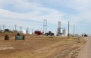
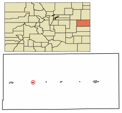
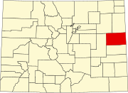
Sheridan Lake is a Statutory Town located in Kiowa County, Colorado, United States. The population was 55 at the 2020 census.

<span class="mw-page-title-main">Stratton, Colorado</span> Town in Kit Carson County, Colorado, United States

Stratton is a statutory town in Kit Carson County, Colorado, United States. The population was 656 at the 2020 census. Stratton was named in honor of the gold miner and philanthropist Winfield Scott Stratton.

<span class="mw-page-title-main">Merino, Colorado</span> Town in Colorado, United States

The Town of Merino is a Statutory Town in Logan County, Colorado, United States. The town population was 281 at the 2020 United States Census.

<span class="mw-page-title-main">Paoli, Colorado</span> Town in Phillips County, Colorado, United States

Paoli is a Statutory Town in Phillips County, Colorado, United States. The population was 51 according to the 2020 census.

<span class="mw-page-title-main">Wiley, Colorado</span> Town in Prowers County, Colorado, United States

Wiley is a Statutory Town in Prowers County, Colorado, United States. The population was 437 at the 2020 Census.

<span class="mw-page-title-main">Meeker, Colorado</span> Town in and county seat of Rio Blanco County, Colorado, United States

Meeker is the Statutory Town in and the county seat of Rio Blanco County, Colorado, United States, that is the most populous municipality in the county. The town population was 2,374 at the 2020 United States Census.

<span class="mw-page-title-main">Julesburg, Colorado</span> Town in Colorado, United States

Julesburg is the statutory town that is the county seat and the most populous municipality of Sedgwick County, Colorado, United States. The population was 1,307 at the 2020 United States Census.

<span class="mw-page-title-main">Ovid, Colorado</span> Town in Colorado, United States

Ovid is a statutory town in Sedgwick County, Colorado, United States. The population was 271 at the 2020 census.

<span class="mw-page-title-main">Otis, Colorado</span> Town in Colorado, United States

Otis is a Statutory Town in Washington County, Colorado, United States. The population was 511 at the 2020 census.

<span class="mw-page-title-main">Hudson, Colorado</span> Town in Colorado, United States

The Town of Hudson is a home rule municipality in Weld County, Colorado, United States. The population was 1,651 at the 2020 census.

<span class="mw-page-title-main">Kersey, Colorado</span> Town in Weld County, Colorado, United States

The Town of Kersey is a Statutory Town in Weld County, Colorado, United States. The population was 1,495 at the 2020 United States Census.

<span class="mw-page-title-main">LaSalle, Colorado</span> Town in Colorado, United States

The Town of LaSalle is a Statutory Town in Weld County, Colorado, United States. The town population was 2,359 at the 2020 United States Census.

<span class="mw-page-title-main">Pierce, Colorado</span> Town in Colorado, United States

Pierce is a Statutory Town in Weld County, Colorado, United States. The population was 1,097 at the 2020 census. The town is a rural agricultural community located on the Colorado Eastern Plains along U.S. Highway 85 north of Greeley.

<span class="mw-page-title-main">Wray, Colorado</span> City in Colorado, United States

Wray is the home rule municipality that is the county seat of Yuma County, Colorado, United States. Located in the Colorado Plains, the city is 170 miles east of Denver, 9 miles west of the Nebraska state line, and 25 miles northwest of the Kansas state line. The population was 2,358 at the 2020 United States census.

<span class="mw-page-title-main">Yuma, Colorado</span> City in Colorado, United States

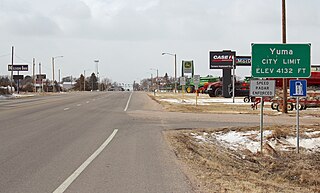
Yuma is a home rule municipality that is the most populous municipality in Yuma County, Colorado, United States. The population was 3,456 at the 2020 census.

References

  1. 1 2 "Active Colorado Municipalities". State of Colorado, Department of Local Affairs. Archived from the original on 2009-12-12. Retrieved 2007-09-01.
  2. "Colorado Municipal Incorporations". State of Colorado, Department of Personnel & Administration, Colorado State Archives. 2004-12-01. Retrieved 2007-09-02.
  3. "2019 U.S. Gazetteer Files". United States Census Bureau. Retrieved July 1, 2020.
  4. "US Board on Geographic Names". United States Geological Survey. 2007-10-25. Retrieved 2008-01-31.
  5. 1 2 United States Census Bureau. "Seibert town; Colorado" . Retrieved April 22, 2023.
  6. "ZIP Code Lookup" (JavaScript/HTML). United States Postal Service . Retrieved January 1, 2008.
  7. "Post offices". Jim Forte Postal History. Retrieved 9 July 2016.
  8. Dawson, John Frank. Place names in Colorado: why 700 communities were so named, 150 of Spanish or Indian origin. Denver, CO: The J. Frank Dawson Publishing Co. p. 46.
  9. "US Gazetteer files: 2010, 2000, and 1990". United States Census Bureau. 2011-02-12. Retrieved 2011-04-23.
  10. "U.S. Climate Normals Quick Access – Station: Seibert, CO". National Oceanic and Atmospheric Administration. Retrieved March 5, 2023.
  11. "NOAA Online Weather Data – NWS Goodland". National Weather Service. Retrieved March 5, 2023.