Oviedo is a city in Seminole County, Florida, United States. As of the 2010 United States Census, the population was 33,342, representing an increase of 7,026 (26.7%) from the 26,316 counted in the 2000 Census. It is part of the Orlando–Kissimmee–Sanford Metropolitan Statistical Area. Oviedo is known for its historic houses and buildings, as well as its population of chickens that roam the downtown area. Although the city has historically been rural, in recent years it has had an influx of new developments to support its rapid growth, due to its proximity to the University of Central Florida and the Central Florida Research Park.

Oak Hill is a city in Volusia County, Florida, United States. The population was 1,792 at the 2010 census.
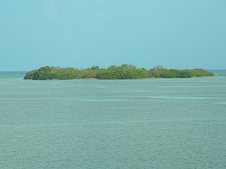
Indian Key Historic State Park is an island within the Florida State Park system, located just a few hundred yards southeast of U.S. 1 within the Florida Keys. The island was home to the town of Indian Key, Florida in the middle of the 19th century but is now an uninhabited ghost town. It is frequently visited by tourists and is the subject of an archaeological project to uncover the historic building foundations.
The city of Tampa, Florida is officially divided into six geographical regions: New Tampa, West Tampa, Brooklyn Village, Downtown Tampa, Ybor City, and Channel District each coinciding with a respective Tampa City Council district. The neighborhoods are managed by Neighborhood and Community Relations, a department under Neighborhood Services, a city department which serves as a resource for residents and businesses.
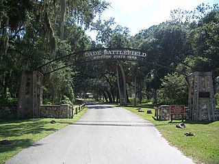
Dade Battlefield Historic State Park is a state park located on County Road 603 between Interstate 75 and U.S. Route 301 in Sumter County, Florida. The 80-acre (32 ha) park includes 40 acres (160,000 m2) of pine flatwoods and a live oak hammock. Also called the Dade Massacre site, it preserves the Second Seminole War battlefield where tribal Seminole warriors fought soldiers under the command of Major Francis L. Dade on December 28, 1835. Each year, on the weekend after Christmas, the Dade Battlefield Society sponsors a reenactment of the battle that started the Second Seminole War.

The Fort Clinch State Park is a Florida State Park, located on a peninsula near the northernmost point of Amelia Island, along the Amelia River. Its 1,100 acres (4 km2) include the 19th-century Fort Clinch, sand dunes, plains, maritime hammock and estuarine tidal marsh. The park and fort lie to the northeast of Fernandina Beach at the entrance to the Cumberland Sound.
Paynes Creek Historic State Park is a Florida State Park located on Lake Branch Road one-half mile southeast of Bowling Green, Florida. On November 21, 1978, it was added to the United States National Register of Historic Places, under the title of Payne's Creek Massacre-Fort Chokonikla Site.
Evergreen Hills Plantation was a large cotton plantation of 6700 acres (27 km2) located in eastern Leon County, Florida, United States established by Green H. Chaires.

The Hampton Terrace Historic District, originally called the Lakewood Manor Subdivision, is a U.S. historic district located in the Old Seminole Heights neighborhood of Tampa, Florida. The district is roughly bounded by Hanna Avenue to the north, 15th Street to the east, Nebraska Avenue to the west, and Hillsborough Avenue to the south. Hampton Terrace Historic District was so designated by its inclusion in the National Register of Historic Places on January 27, 1999.

The Seminole Heights Residential District, known also as the Seminole Heights Historic District, is a U.S. and Local Historic District located in Tampa, Florida. The district is roughly bounded by Hanna Avenue to the north, Cherokee Avenue and I-275 to the east, Florida Avenue to the west, and Osborne Avenue to the south.

The Sanford Commercial District is a U.S. Historic District located in Sanford, Florida. The district includes parts of 1st, 2nd, and Commercial Streets, between Palmetto and Oak Streets. It contains 29 historic buildings, including the PICO Building at 209 North Oak.

Fort Foster is a Second Seminole War era fort in central Florida, located 9 miles (14 km) south of current-day Zephyrhills in Pasco County.
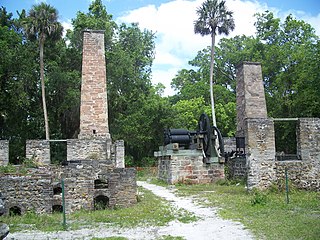
The Dunlawton Plantation and Sugar Mill, a 19th-century cane sugar plantation in north-central Florida, was destroyed by the Seminoles at the beginning of the Second Seminole War. The ruins are located at 950 Old Sugar Mill Road, Port Orange, Florida. On August 28, 1973, the site was added to the United States National Register of Historic Places under the title of Dunlawton Plantation-Sugar Mill Ruins.

The Old Fernald-Laughton Memorial Hospital is a historic site in Sanford, Florida, United States. It is located at 500 South Oak Avenue. On May 21, 1987, it was added to the U.S. National Register of Historic Places.

The Sanford Grammar School, also known as the Sanford High School and as the Margaret K. Reynolds Building, is a historic school building located at 301 West 7th Street in Sanford, Florida, United States. Built in 1902, it was designed by Wilbur B. Talley in the Romanesque Revival style of architecture. Sanford architect Elton James Moughton designed the wings which were added in 1916. On November 23, 1984, it was added to the U.S. National Register of Historic Places.

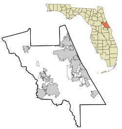
This is a list of the National Register of Historic Places listings in Seminole County, Florida.
Old Seminole Heights is a neighborhood within the city limits of Tampa, in the U.S. state of Florida. The neighborhood is one of three which comprise the greater Seminole Heights district within the city. As of the 2010 census the neighborhood had a population of 14,729. The ZIP Codes serving the area are 33603, 33604, and 33610.

The Red Barn is a historic barn located on the Brighton Seminole Indian Reservation in Glades County, Florida. It was built in 1941 with help from the Civilian Conservation Corps to serve the Seminole cattle business. It has a dirt floor and rests on a concrete block foundation. Its roof was replaced with a metal one after Hurricane Wilma in 2005. On December 24, 2008, it was added to the National Register of Historic Places.

The Council Oak Tree is an historic oak tree on the Hollywood Seminole Indian Reservation in Hollywood, Florida, at the intersection between U.S. 441 and Stirling Rd. It has been the site for many important events in the history of the Seminole Tribe of Florida since at least 1957. Some of the events in the early 21st century include the 25th Anniversary celebration for the birthplace of Indian gaming (2004), the Tribe's 50th Anniversary celebration (2007), and the signing of the Seminole Gaming Compact (2010). The tree's image serves as a tribal logo. A restaurant at both the Seminole Hard Rock Hotel & Casino Hollywood and Seminole Hard Rock Hotel and Casino Tampa is named for the Council Oak. The documents for the purchase of the hotel, casino and contents were signed under the Council Oak Tree. On December 4, 2012, it was added to the National Register of Historic Places as Council Oak Tree Site on the Hollywood Seminole Indian Reservation.