Separation barrier

Last updated

The Berlin Wall divided Berlin from 1961 until 1989, and was demolished between 1990 and 1992. Berlinermauer.jpg
The Berlin Wall divided Berlin from 1961 until 1989, and was demolished between 1990 and 1992.

A separation barrier or separation wall is a barrier, wall or fence, constructed to limit the movement of people across a certain line or border, or to separate peoples or cultures. [1] A separation barrier that runs along an internationally recognized border is known as a border barrier.[ citation needed ]

Contents

David Henley opines in The Guardian that separation barriers are being built at a record-rate around the world along borders and do not only surround dictatorships or pariah states. In 2014, The Washington Post listed notable 14 separation walls as of 2011, indicating that the total concurrent number of walls and barriers which separate countries and territories is 45. [2]

The term "separation barrier" has been applied to structures erected in Belfast, Homs, the West Bank, São Paulo, Cyprus, and along the Greece-Turkey border and the Mexico-United States border. In 2016, Julia Sonnevend listed in her book Stories Without Borders: The Berlin Wall and the Making of a Global Iconic Event the concurrent separation barriers of Sharm el-Sheikh (Egypt), Limbang border (Brunei), the Kazakh-Uzbekistan barrier, Indian border fence with Bangladesh, United States separation barrier with Mexico, Saudi Arabian border fence with Iraq and Hungary's fence with Serbia. [3] Several erected separation barriers are no longer active or in place, including the Berlin Wall, the Maginot Line and some barrier sections in Jerusalem. [4]

Construction rate of separation barriers and walls

David Henley opines in The Guardian that separation barriers are being built at a record-rate around the world along borders and do not only surround dictatorships or pariah states. In 2014, The Washington Post listed notable 14 separation walls as of 2011, indicating that the total concurrent number of walls and barriers which separate countries and territories is 45. [2]

Structures described as "separation barriers" or "separation walls"

Central Europe

Communities in the Czech Republic, Romania and Slovakia have long built Roma walls in urban environments when a Roma group is in close proximity to the rest of the population. [5]

Cyprus

Green Line separation barrier, Cyprus Green Line near Paphos Gate.JPG
Green Line separation barrier, Cyprus

Since the Turkish invasion of Cyprus in 1974, Turkey has constructed and maintained what economics professor Rongxing Guo has called a "separation barrier" of 300 kilometres (190 mi) along the 1974 Green Line (or ceasefire line) dividing the island of Cyprus into two parts, with a United Nations buffer zone between them. [6]

Egypt

Egypt-Gaza barrier

Rafah Border Crossing Road to Gaza 060 - Flickr - Al Jazeera English.jpg
Rafah Border Crossing

The Egypt–Gaza barrier is often referred as "separation barrier" in the media [7] or as a "separating wall". [8] [9] [10] In December 2009, Egypt started the construction of the Egypt–Gaza barrier along the border with Gaza, consisting of a steel wall. Egypt's foreign minister said that the wall, being built along the country's border with the Gaza Strip will defend it "against threats to national security". [11] Though the construction paused a number of times, the wall is nearly complete.

Sharm el-Sheikh barrier

According to Julia Sonnevend, the anti-terrorist barrier around the Sharm el-Sheikh resort in Egypt is in fact a separation barrier. [3]

India

The Line of Control (LoC) refers to the military control line between the Indian and Pakistani controlled parts of the former princely state of Kashmir and Jammu—a line which, to this day, does not constitute a legally recognized international boundary, but is the de facto border. Originally known as the Cease-fire Line, it was redesignated as the "Line of Control" following the Simla Agreement, which was signed on 3 July 1972. The part of the former princely state that is under Indian control was known as the state of Jammu and Kashmir, which was split into two separate Union Territories. The two parts of the former princely state that are under Pakistani control are known as Gilgit–Baltistan and Azad Kashmir (AJK). Its northernmost point is known as the NJ9842. This territorial division, which to this day still exists, severed many villages and separated family members from each other. [12] [13]

A separation fence construction between Indian and Pakistani controlled areas, based on 1972 cease-fire line, was initiated by India in 2003. [14] In December 2013, it was revealed that India plans a construction of a separation wall in the Himalayan area in Kashmir. [15] The wall is aimed to cover 179 km.

The India-Pakistan border seen at night India-Pakistan Border at Night.jpg
The India-Pakistan border seen at night

The other sections of India's borders also have a fence or wall.

Israel

Israeli West Bank barrier between East Jerusalem and Abu Dis Israel - Jerusalem - Mount Zion - 03 (4261536735).jpg
Israeli West Bank barrier between East Jerusalem and Abu Dis
Israeli West Bank barrier and Beit Surik behind it BeitSurikJune032022.jpg
Israeli West Bank barrier and Beit Surik behind it
Israeli West Bank barrier in Bethlehem Die Mauer von Bethlehem.jpg
Israeli West Bank barrier in Bethlehem

Israel began building the Israeli West Bank barrier in 2002, in order to protect civilians from Palestinian terrorism such as suicide bombing attacks which increased significantly during the Second Intifada. Barrier opponents claim it seeks to annex Palestinian land under the guise of security and undermines peace negotiations by unilaterally establishing new borders. When completed it will be a 700-kilometres long network of high walls, electronic fences, gates and trenches. It is a controversial barrier because much of it is built outside the 1949 Armistice Line (Green Line), de facto annexing potentially 10 percent of Palestinian land, according to the United Nations Office for the Coordination of Humanitarian Affairs. It cuts far into the West Bank and encompasses Israel's largest settlement blocs containing hundreds of thousands of settlers.

In June 2004, the Israeli Supreme Court held that building the wall on West Bank Palestinian land is in itself legal, but it ordered some changes to the original route, which separated 35,000 Palestinian farmers from their lands and crops. The Israeli finance minister replied that it was disputed land, not Palestinian, and its final status would be resolved in political negotiation. [16] In July 2004, the International Court of Justice at The Hague in an advisory opinion declared the barriers illegal under international law and called on Israel to dismantle the walls, return confiscated land and make reparations for damages. [17] [18] In spite of all this, the number of Arab terrorist suicide bombings continued to decrease with the gradual completion of segments of the Security Barrier as was initially stated it would by the Israeli authorities. [19] [20]

Israel refers to land between the 1949 lines and the separation barrier as the Seam Zone, including all of East Jerusalem. In 2003, the military declared that only Israeli citizens and Palestinians with permits are allowed to be inside it; Palestinians have found it increasingly difficult to get permits unless they own land in the zone. [21] [22] The separation barrier cuts off east Jerusalem and some settlement blocs from the West Bank, even as Israelis and Arabs build structures and communities in eastern Jerusalem. [23] Palestinians in the West Bank, including East Jerusalem, have continued to protest the separation barrier. [24]

The existing barrier cuts off access to the Jordan River for Palestinian farmers in the West Bank. [25] Due to international condemnation after the International Court ruling, Israel did not build an even stronger barrier, instead instituting permit-based access control. [26] It has been opined that this change was to allow land to be annexed. [27] [ better source needed ] Israeli settlement councils already have de facto control of 86 percent of the Jordan Valley and the Dead Sea [28] as the settler population steadily grows there. [29]

Kuwait

Writer Damon DiMarco has described as a "separation barrier" the Kuwait-Iraq barricade constructed by the United Nations in 1991 after the Iraqi invasion of Kuwait was repelled. With electrified fencing and concertina wire, it includes a 5-meter-wide trench and a high berm. It runs 180 kilometers along the border between the two nations. [30]

US soldiers closing the border barrier Flickr - The U.S. Army - Closing the gate.jpg
US soldiers closing the border barrier

Lebanon

A 2016 separation wall around the Ain al-Hilweh camp in Lebanon is intended to separate the local Palestinian-Lebanese population and Syrian refugee Palestinians from the surrounding society. [31]

Malaysia

Renee Pirrong of The Heritage Foundation described the Malaysia–Thailand border barrier as a "separation barrier". Its purpose is to cut down on smuggling, drug trafficking, illegal immigration, crime and insurgency. [32]

Wall between Malaysia and Thailand Padang Besar, Perlis, Malaysia - panoramio.jpg
Wall between Malaysia and Thailand

Saudi Arabia

In 2004 Saudi Arabia began construction of a Saudi-Yemen barrier between its territory and Yemen to prevent the unauthorized movement of people and goods into and out of the Kingdom. Some have labeled it a "separation barrier". [33] In February 2004 The Guardian reported that Yemeni opposition newspapers likened the barrier to the Israeli West Bank barrier, [34] while The Independent wrote "Saudi Arabia, one of the most vocal critics in the Arab world of Israel's 'security fence' in the West Bank, is quietly emulating the Israeli example by erecting a barrier along its porous border with Yemen". [35] Saudi officials rejected the comparison saying it was built to prevent infiltration and smuggling. [34]

Saudi Arabia has also built a wall on the Saudi Iraqi border.

Turkey

Turkish border guards manning armoured vehicles disperse protesters with a water cannon along the Turkey-Syria fence in Kobani. Turkish border guards disperse protesters in Kobani.png
Turkish border guards manning armoured vehicles disperse protesters with a water cannon along the Turkey–Syria fence in Kobanî.

The Syria–Turkey barrier is a wall and fence under construction along the Syria–Turkey border aimed at preventing illegal crossings and smuggling from Syria into Turkey. [37] In 2017, The Syrian government accused Turkey of building a separation wall, referring to the barrier. [38]

From 2017, Turkey began construction a barrier along the Iran–Turkey border aimed at preventing illegal immigration and smuggling. [39]

United Kingdom

Gates in a "peace line" in West Belfast Gates in the 'Peace Line'.jpg
Gates in a "peace line" in West Belfast

Over 21 miles of high walling or fencing separate Catholic and Protestant communities in Northern Ireland, with most concentrated in Belfast and Derry. The wall[ clarification needed ] was built in 1969 in order to separate the Catholic and Protestant areas in Belfast. [40] An Army Major, overseeing the construction of the wall at the time, said: 'This is a temporary measure ... we do not want to see another Berlin wall situation in Western Europe ... it will be gone by Christmas'. In 2013, that wall still remains and almost 100 additional walls and barriers now complement the original. Technically known as 'peace walls', there are moves to remove all of them by 2023 by mutual consent. [41]

United States

A barrier along the US-Mexico border. A US Border Patrol watches the barrier. US-Mexico border fence.jpg
A barrier along the US-Mexico border. A US Border Patrol watches the barrier.

The United States constructed a barrier on the border with Mexico of 3,169 kilometres (1,969 mi) to prevent unauthorized immigration into the United States and to deter smuggling of contraband. The US President Trump stated that he would replace the wall with a Trump wall; some parts of the old wall have been replaced. [42]

The Detroit Wall was erected to enforce redlining as part of the policies of racial segregation in the United States.

Western Sahara

System of the Moroccan Walls in Western Sahara with chronology of their construction Western sahara walls moroccan map-en.svg
System of the Moroccan Walls in Western Sahara with chronology of their construction

Morocco has constructed a 2,700 km (1,700 mi) long sand wall cutting through the length of Western Sahara. [43] [44] Minefields and watchtowers serve to separate the Moroccan-controlled zone from the sparsely populated Free Zone.

Past separation barriers

Germany

People climb onto the wall near Brandenburg Gate during the fall of the Berlin Wall, November 1989. BerlinWall-BrandenburgGate.jpg
People climb onto the wall near Brandenburg Gate during the fall of the Berlin Wall, November 1989.

The Berlin Wall was a barrier that divided Berlin from 1961 to 1989, [45] constructed by the German Democratic Republic (GDR, East Germany) starting on 13 August 1961, that completely cut off (by land) West Berlin from surrounding East Germany and from East Berlin until it was opened in November 1989. [46] Its demolition officially began on 13 June 1990 and was completed in 1992. [47] The barrier included guard towers placed along large concrete walls, [48] which circumscribed a wide area (later known as the "death strip") that contained anti-vehicle trenches, "fakir beds" and other defenses. The Eastern Bloc claimed that the wall was erected to protect its population from fascist elements conspiring to prevent the "will of the people" in building a socialist state in East Germany. In practice, the Wall served to prevent the massive emigration and defection that marked East Germany and the communist Eastern Bloc during the post-World War II period.

The Berlin Wall was officially referred to as the "Anti-Fascist Protection Rampart" (German : Antifaschistischer Schutzwall) by GDR authorities, implying that the NATO countries and West Germany in particular were "fascists". [49] The West Berlin city government sometimes referred to it as the "Wall of Shame"—a term coined by mayor Willy Brandt—while condemning the Wall's restriction on freedom of movement. Along with the separate and much longer Inner German border (IGB), which demarcated the border between East and West Germany, it came to symbolize the "Iron Curtain" that separated Western Europe and the Eastern Bloc during the Cold War.

Before the Wall's erection, 3.5 million East Germans circumvented Eastern Bloc emigration restrictions and defected from the GDR, many by crossing over the border from East Berlin into West Berlin, from where they could then travel to West Germany and other Western European countries. Between 1961 and 1989, the wall prevented almost all such emigration. [50] During this period, around 5,000 people attempted to escape over the wall, with an estimated death toll of from 136 [51] to more than 200 [52] in and around Berlin.

In 1989, a series of radical political changes occurred in the Eastern Bloc, associated with the liberalization of the Eastern Bloc's authoritarian systems and the erosion of political power in the pro-Soviet governments in nearby Poland and Hungary. After several weeks of civil unrest, the East German government announced on 9 November 1989 that all GDR citizens could visit West Germany and West Berlin. Crowds of East Germans crossed and climbed onto the wall, joined by West Germans on the other side in a celebratory atmosphere. Over the next few weeks, euphoric people and souvenir hunters chipped away parts of the wall; the governments later used industrial equipment to remove most of what was left. Contrary to popular belief the wall's actual demolition did not begin until the summer of 1990 and was not completed until 1992. [45] The fall of the Berlin Wall paved the way for German reunification, which was formally concluded on 3 October 1990.

Map of separation barriers worldwide

Carte des barrieres de separation.svg

See also

Related Research Articles

<span class="mw-page-title-main">Hamas</span> Palestinian political and military organization

Hamas, an acronym of its official name, Harakat al-Muqawama al-Islamiya, is a Palestinian Sunni Islamist political and military movement governing parts of the occupied Gaza Strip.

<span class="mw-page-title-main">Israeli–Palestinian conflict</span> Ongoing military and political conflict in the Levant

The Israeli–Palestinian conflict, is an ongoing military and political conflict about self-determination within the territory of the former Mandatory Palestine. Key aspects of the conflict include the Israeli occupation of the West Bank and Gaza Strip, the status of Jerusalem, Israeli settlements, borders, security, water rights, Palestinian freedom of movement, and the Palestinian right of return.

<span class="mw-page-title-main">Palestinian territories</span> Occupied Palestinian territory in the Middle East

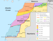
The Palestinian territories are the two regions of the former British Mandate for Palestine that have been occupied by Israel since the Six-Day War of 1967, namely the West Bank and the Gaza Strip. The International Court of Justice (ICJ) has referred to the West Bank, including East Jerusalem, as "the Occupied Palestinian Territory", and this term was used as the legal definition by the ICJ in its advisory opinion of July 2004. The term occupied Palestinian territory was used by the United Nations and other international organizations between October 1999 and December 2012 to refer to areas controlled by the Palestinian National Authority, but from 2012, when Palestine was admitted as one of its non-member observer states, the United Nations started using exclusively the name State of Palestine. The European Union (EU) also uses the term "occupied Palestinian territory". The government of Israel and its supporters use the label "disputed territories" instead.

<span class="mw-page-title-main">Israeli West Bank barrier</span> Separation barrier built by Israel inside and around the West Bank since 2000

The Israeli West Bank barrier, comprising the West Bank Wall and the West Bank fence, is a separation barrier built by Israel along the Green Line and inside parts of the West Bank. Israel describes the wall as a necessary security barrier against Palestinian political violence; whereas Palestinians describe it as an element of racial segregation and a representation of Israeli apartheid, who often call it "Wall of Apartheid". At a total length of 708 kilometres (440 mi) upon completion, the route traced by the barrier is more than double the length of the Green Line, with 15% of its length running along the Green Line or inside Israel, and the remaining 85% running as much as 18 kilometres (11 mi) inside the West Bank, effectively isolating about 9% of the land and approximately 25,000 Palestinians from the rest of the Palestinian territory.

<span class="mw-page-title-main">Gaza–Israel barrier</span> Border barrier between the Palestinian Gaza Strip and Israel

The Gaza–Israel barrier is a border barrier located on the Israeli side of the Gaza–Israel border. The Erez Crossing, in the north of the Gaza Strip, is the only crossing point for people and goods coming from Israel into the Gaza Strip; there exists a second crossing point in the barrier, called the Kerem Shalom border crossing, which is exclusive for the crossing of goods coming from Egypt, as Israel does not allow goods to go directly from Egypt into Gaza through the Egypt–Gaza border.

<span class="mw-page-title-main">Philadelphi Corridor</span> Strip of land on the Egypt-Gaza border

The Philadelphi Corridor, also called Philadelphi Route or Saladin Axis, is the Israeli code name for a narrow strip of land, 14 km in length, situated along the entirety of the border between Gaza Strip and Egypt.

The International law bearing on issues of Arab–Israeli conflict, which became a major arena of regional and international tension since the birth of Israel in 1948, resulting in several disputes between a number of Arab countries and Israel.

The Green Line, (pre-)1967 border, or 1949 Armistice border is the demarcation line set out in the 1949 Armistice Agreements between the armies of Israel and those of its neighbors after the 1948 Arab–Israeli War. It served as the de facto borders of the State of Israel from 1949 until the Six-Day War in 1967, and continues to represent Israel’s internationally recognized borders with the two Palestinian territories: the West Bank and the Gaza Strip.

<span class="mw-page-title-main">Wall of Shame</span> Term used referring to the Berlin Wall

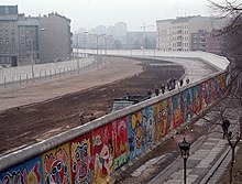
"Wall of Shame" is a phrase that is most commonly associated with the Berlin Wall. In this context, the phrase was coined by Willy Brandt, and it was used by the government of West Berlin, and later popularized in the English-speaking world and elsewhere from the beginning of the 1960s. Inspired by its usage in reference to the Berlin Wall, the term has later been used more widely.

<span class="mw-page-title-main">Israeli-occupied territories</span> Territories presently occupied by Israel since the 1967 Six-Day War

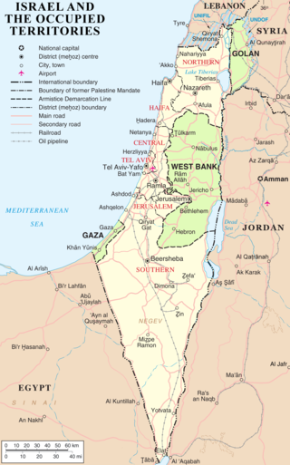
Israel has occupied the Palestinian territories and the Golan Heights since the Six-Day War of 1967. It previously occupied the Sinai Peninsula and southern Lebanon as well. Prior to Israel's victory in the Six-Day War, occupation of the Palestinian territories was split between Egypt and Jordan, with the former having occupied the Gaza Strip and the latter having annexed the West Bank; the Sinai Peninsula and the Golan Heights were under the sovereignty of Egypt and Syria, respectively. The first conjoined usage of the terms "occupied" and "territories" with regard to Israel was in United Nations Security Council Resolution 242, which was drafted in the aftermath of the Six-Day War and called for: "the establishment of a just and lasting peace in the Middle East" to be achieved by "the application of both the following principles: ... Withdrawal of Israeli armed forces from territories occupied in the recent conflict ... Termination of all claims or states of belligerency and respect for and acknowledgment of the sovereignty, territorial integrity and political independence of every State in the area and their right to live in peace within secure and recognized boundaries free from threats or acts of force."

<span class="mw-page-title-main">Allon Plan</span> 1967 plan to distribute the territory around Israel

The Allon Plan was a political proposition that outlined potential next steps for Israel after the 1967 Arab–Israeli War. It was drafted by Israeli politician Yigal Allon following Israel's seizure of territory from Syria, Jordan, and Egypt; the Israeli military had come to occupy Syria's Golan Heights, the Jordanian-annexed West Bank and the Egyptian-occupied Gaza Strip, and Egypt's Sinai Peninsula. Allon advocated a partitioning of the West Bank between Israel and Jordan, the creation of a sovereign state for Druze in the Golan Heights, and the return of most of the Sinai Peninsula to Egypt.

<span class="mw-page-title-main">Arab–Israeli conflict</span> Geopolitical conflict in the Middle East and North Africa

The Arab–Israeli conflict is the phenomenon involving political tension, military conflicts, and other disputes between various Arab countries and Israel, which escalated during the 20th century. The roots of the Arab–Israeli conflict have been attributed to the support by Arab League member countries for the Palestinians, a fellow League member, in the ongoing Israeli–Palestinian conflict; this in turn has been attributed to the simultaneous rise of Zionism and Arab nationalism towards the end of the 19th century, though the two national movements had not clashed until the 1920s.

<span class="mw-page-title-main">Seam Zone</span> Land area in the West Bank

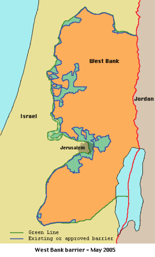
Seam Zone is a term used to refer to a land area in the Israeli-occupied West Bank located east of the Green Line and west of Israel's separation barrier, populated largely by Israelis in settlements such as Alfei Menashe, Ariel, Beit Arye, Modi'in Illit, Giv'at Ze'ev, Ma'ale Adumim, Beitar Illit and Efrat.

<span class="mw-page-title-main">2008 breach of the Egypt–Gaza border</span> Explosion set off by Hamas militants

On 23 January 2008, Hamas militants in the Gaza Strip set off an explosion near the Rafah border crossing, destroying part of the 2003 wall. The United Nations estimates that as many as half the 1.5 million population of the Gaza Strip crossed the border into Egypt seeking food and supplies. Due to fears that militants would acquire weapons in Egypt, Israeli police went on increased alert.

<span class="mw-page-title-main">Blockade of the Gaza Strip</span> 2005–present land, sea and air blockade by Israel and Egypt

A blockade has been imposed on the movement of goods and people in and out of the Gaza Strip following Hamas's takeover in 2007, led by Israel and supported by Egypt. The blockade's current stated aim is to prevent the smuggling of weapons into Gaza, although previously stated motivations have included exerting economic pressure on Hamas. Human rights groups have described the blockade as illegal and a form of collective punishment as it restricts the flow of essential goods, contributes to economic hardship, and limits the freedom of movement for Gaza's residents. The blockade and its effects have led to the territory being described as an "open-air prison".

<span class="mw-page-title-main">Hafrada</span> Israeli separation policy

Hafrada is the policy of the government of Israel to separate the Israeli population from the Palestinian population in the occupied Palestinian territories, in both the West Bank and the Gaza Strip.

<span class="mw-page-title-main">Egypt–Gaza barrier</span> Border barrier between Egypt and the Palestinian Gaza Strip

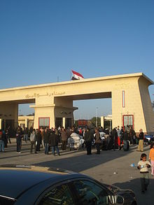
The Egypt–Gaza barrier is a steel border barrier constructed by Egypt along its 14 km border with the Gaza Strip. The Rafah border crossing is the only border crossing between the Gaza Strip and Egypt.

<span class="mw-page-title-main">Egypt–Israel barrier</span> Barrier built by Israel along its border with Egypt

The Egypt–Israel barrier or Egypt–Israel border fence refers to a separation barrier built by Israel along its border with Egypt. Initial construction on the barrier began on 22 November 2010, and its original purpose as a common fence was to curb the large influx of illegal migrants from African countries into Israel. However, in the wake of the Egyptian Crisis after the 2011 Revolution, Israel's southwestern border with Egypt experienced an increase in militant jihadist activity with the outbreak of the Sinai insurgency. In response, Israel upgraded the steel barrier—called Project Hourglass by the Israel Defense Forces (IDF)—to include cameras, radars, and motion detectors. In January 2013, construction on the barrier's main section was completed; the final section was completed in December 2013.

Nakba Day in 2011 was the annual day of commemoration for the Palestinian people marking the Nakba—the displacement that accompanied the creation of Israel in 1948. Generally held on May 15, commemorative events in 2011 began on May 10, in the form of march by Palestinian Arab citizens of Israel on Israel's Independence Day. On May 13, clashes between stone-throwing youths and Israeli security forces in East Jerusalem resulted in one Palestinian fatality, and clashes continued there and in parts of the West Bank in the days following.

References

  1. "The fence along the Mexican-U.S. border is just one of many barriers proposed or constructed around the world to keep people and cultures separated. Learn more about them below."
  2. 1 2 Noack, Rick (11 November 2014). "These 14 walls continue to separate the world" . Retrieved 21 April 2018 via www.washingtonpost.com.
  3. 1 2 Julia Sonnevend. Stories Without Borders: The Berlin Wall and the Making of a Global Iconic Event. Oxford University Press. 2016.
  4. David Henley, Walls: an illusion of security from Berlin to the West Bank, The Guardian , November 19, 2013.
  5. Furlong, Ray (24 November 1999). "Czechs pull down Gypsy wall". BBC . Retrieved 7 July 2013.
  6. Rongxing Guo, Territorial Disputes and Resource Management: A Global Handbook, Nova Publishers, 2006, p 91, ISBN   1600214452, 9781600214455
  7. "Egypt-Gaza Border Quiet Despite Political Rhetoric - Al-Monitor: the Pulse of the Middle East". Al-Monitor. 9 October 2013. Archived from the original on 11 December 2013. Retrieved 22 November 2013.
  8. Fleishman, Jeffrey; Hassan, Amro (21 December 2009). "Egypt's barrier along Gaza border called 'wall of shame' - Los Angeles Times". Articles.latimes.com. Retrieved 22 November 2013.
  9. Younis, Nora; Knickmeyer, Ellen (26 January 2008). "Dear Palestinian Brothers . . . Please Return to Gaza". Washingtonpost.com. Retrieved 22 November 2013.
  10. Erlanger, Steven (26 January 2008). "Egypt Tries to Plug Border; Gazans Poke New Hole". The New York Times . Retrieved 22 November 2013.
  11. "Egypt defends Gaza wall - Middle East". Al Jazeera English. Retrieved 22 November 2013.
  12. Ranjan Kumar Singh, Sarhad: Zero Mile, (Hindi), Parijat Prakashan, ISBN   81-903561-0-0
  13. Women in Security, Conflict Management, a Peace (Program) (2008). Closer to ourselves: stories from the journ towards peace in South Asia. WISCOMP, Foundation for Universal Responsibility of His Holiness the Dalai Lama 2008. p. 75. Retrieved 19 June 2013.{{cite book}}: CS1 maint: multiple names: authors list (link)
  14. "It is a fence, meant to keep at bay infiltrators from Pakistan who are seeking to separate India's portion of Kashmir from India."
  15. Umar, Baba. "India planning a 'separation wall' in Kashmir". www.aljazeera.com. Retrieved 21 April 2018.
  16. "USATODAY.com - Israel orders separation barrier changes". Usatoday30.usatoday.com. 30 June 2004. Retrieved 22 November 2013.
  17. "U.N. court rules West Bank barrier illegal - Jul 9, 2004". CNN.com. 10 July 2004. Retrieved 22 November 2013.
  18. "International Court of Justice - Legal consequences of the construction of a Wall in the Occupied Palestinian Territory - Written Statement submitted by Palestine" (PDF). Cnn.com. 30 January 2004. p. 364. Retrieved 22 November 2013.
  19. Ministry of Defense. "Israel Security Fence". MoD. Archived from the original on 3 October 2013. Retrieved 6 May 2015.
  20. Bard, Mitchell. "West bank Security Fence". Jewish Virtual Library. Retrieved 6 May 2015.
  21. "Israel's Separation Barrier:Challenges to the Rule of Law and Human Rights: Executive Summary Part I and II" (PDF). International Commission of Jurists. 6 July 2004. Archived from the original (PDF) on 18 April 2012. Retrieved 27 May 2012.
  22. "Cabinet Communique". 1 October 2003. Retrieved 31 August 2007.
  23. "Palestinian official rejects partial Israeli settlement freeze to restart peace talks". OregonLive.com. 24 March 2013. Retrieved 22 November 2013.
  24. Ben Ehrenreich, Is This Where the Third Intifada Will Start?, New York Times, March 15, 2013.
  25. Ferry Biedermann, Mideast: Environment Too Encounters a Barrier, Inter Press Service, November 25, 2004.
  26. "13 Feb. 2006: Israel has de facto annexed the Jordan Valley | B'Tselem". Btselem.org. 13 February 2006. Retrieved 22 November 2013.
  27. Akiva Eldar, Israel effectively annexes Palestinian land near Jordan Valley, Haaretz, November 18, 2011.
  28. "Beyond the E-1 Israeli settlement | Maan News Agency". Maannews.net. Retrieved 22 November 2013.
  29. "EU on verge of abandoning hope for a viable Palestinian state". BelfastTelegraph.co.uk. 12 January 2012. Retrieved 22 November 2013.
  30. Damon DiMarco, Heart of War: Soldiers? Voices, Citadel Press, 2007, p. 129, ISBN   0806528141, 9780806528144
  31. Arab, The New (19 November 2016). "Lebanon begins building 'security wall' around Palestinian refugee camp". alaraby.co.uk. Retrieved 21 April 2018.
  32. Renee Pirron, http://blog.heritage.org/2010/08/06/fences-and-neighbors/, The Heritage Foundation blog, August 6, 2010
  33. Anthony H. Cordesman, Saudi Arabia: National Security in a Troubled Region, p. 276.
  34. 1 2 Whitaker, Brian (17 February 2004). "Saudi security barrier stirs anger in Yemen". The Guardian. London. Retrieved 23 March 2007.
  35. Bradley, John (11 February 2004). "Saudi Arabia enrages Yemen with fence". The Independent . London. Archived from the original on 9 April 2011. Retrieved 23 March 2007.
  36. "AP: In the Turkish forces attack, 1 killed in Kobani, dozens injured". Voice of America. 2 September 2016.
  37. Reuters: "Turkish developer confident Syria wall in place by spring" By Nevzat Devranoglu and Orhan Coskun December 9, 2016
  38. "Damascus accuses Turkey of building separation wall in northern Syria - Xinhua | English.news.cn".
  39. Hürriyet Daily News: "Turkey builds 700 kilometer long wall on Syrian border" 15 June 2017
  40. "The wall was built in 1969 to separate the Catholic Falls Road and the Protestant Shankill Road. An Army Major, overseeing the construction of the wall at the time, said: 'This is a temporary measure ... we do not want to see another Berlin wall situation in Western Europe ... it will be gone by Christmas'. In 2019, that wall still remains and almost 100 additional walls and barriers now complement the original. "
  41. "Robinson and McGuinness want "peace walls" down within 10 years". The Irish Times. 10 May 2013. Retrieved 5 January 2014.
  42. "Trump wall: How much has he actually built?". BBC News. 31 October 2020.
  43. Stevenson, Tom. "Inside disputed Western Sahara". www.aljazeera.com. Retrieved 21 April 2018.
  44. Noack, Rick (11 November 2014). "These 14 walls continue to separate the world" . Retrieved 21 April 2018 via www.washingtonpost.com.
  45. 1 2 Chicago Tribune (31 October 2014). "Untangling 5 myths about the Berlin Wall". chicagotribune.com. Retrieved 1 November 2014.
  46. Video: Berlin, 1961/08/31 (1961). Universal Newsreel. 1961. Retrieved 20 February 2012.
  47. Ryan, Órla (9 November 2014). "In Photos: 25 years ago today the Berlin Wall fell". thejournal.ie. Retrieved 21 April 2018.
  48. Jack Marck Archived 2008-08-29 at the Wayback Machine "Over the Wall: A Once-in-a-Lifetime Experience" American Heritage, October 2006.
  49. Archived 15 July 2011 at the Wayback Machine [ dead link ]
  50. "Freedom! – TIME". TIME<!. 20 November 1989. Archived from the original on 21 November 2007. Retrieved 9 November 2009.
  51. "Forschungsprojekt "Die Todesopfer an der Berliner Mauer, 1961–1989": BILANZ (Stand: 7. August 2008) (in German)" . Retrieved 6 August 2011.
  52. "Center for Contemporary Historical Research (Zentrum für Zeithistorische Forschung Potsdam e.V) in German". Chronik-der-mauer.de. Retrieved 6 August 2011.