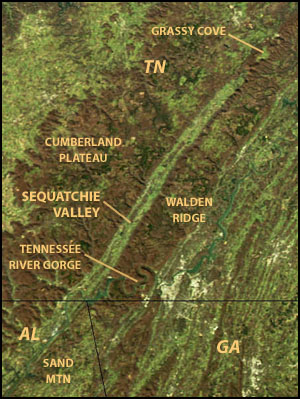
NASA satellite image showing Tennessee's Sequatchie Valley and the Cumberland Plateau (image source: Aqua satellite, MODIS sensor).
Sequatchie Valley is a relatively long and narrow valley in the U.S. state of Tennessee and, in some definitions, Alabama. It is generally considered to be part of the Cumberland Plateau region of the Appalachian Mountains; it was probably formed by erosion of a compression anticline, rather than rifting process as had been formerly theorized.
Geologically, the Sequatchie Valley continues south of the Tennessee River into central Alabama. The Tennessee River flows through the Alabama portion of the valley to the vicinity of Guntersville, Alabama. The valley continues south of Guntersville, where it is called Browns Valley, drained by Browns Creek (Thornbury 1965:148). Although this whole valley is geologically the same, the name Sequatchie is commonly used only for the Tennessee portion of the valley, through which the Sequatchie River flows.
A distinctive feature of the Sequatchie Valley is its straightness. From its northern end to its geological southern end at Browns Valley, the valley is almost perfectly straight. It is over 150 miles (240km) long in the geologic sense and about 65 miles (105km) long as the valley of the Sequatchie River. Its width is about 3–5 miles (5–8km).
The valley is bounded on either side by escarpments of the Cumberland Plateau. The portion of the plateau east of the valley is relatively narrow and known as Walden Ridge in Tennessee. To the west the plateau is simply called the Cumberland Plateau. In Bledsoe County, Tennessee a section of the west side escarpment is called Little Mountain, which also marks the Tennessee Valley Divide. In Alabama the plateau to the east of the valley is called Sand Mountain, while that to the west is Gunters Mountain.
At its northern end, the Sequatchie Valley is marked by a more mountainous portion of the Cumberland Plateau known as the Crab Orchard Mountains. Between the main Crab Orchard Mountains and the Sequatchie Valley there is another valley, called Grassy Cove, located several miles north of Sequatchie Valley. Grassy Cove is a karst valley which, through underground erosion, should eventually become part of Sequatchie Valley (Thornbury 1965:149). Another, smaller karst valley, Bat Town Cove, is forming northeast of Grassy Cove, which may also grow and eventually become part of Sequatchie Valley.
Sequatchie County is a county located in the U.S. state of Tennessee. As of the 2020 census, the population was 15,826. Its county seat is Dunlap. Sequatchie County is part of the Chattanooga, TN–GA Metropolitan Statistical Area.
Cumberland County is a county located in the U.S. state of Tennessee. As of the 2020 census, the population was 61,145. Its county seat is Crossville. Cumberland County comprises the Crossville, TN micropolitan statistical area.
Jasper is a town in and the county seat of Marion County, Tennessee, United States. The population was 3,612 at the 2020 census. The town was formed in 1820 from lands acquired from Betsy Pack (1770–1851), daughter of Cherokee Chief John Lowery. Jasper is part of the Chattanooga, TN–GA Metropolitan Statistical Area.
Whitwell is a city in Marion County, Tennessee, United States, approximately 24 miles northwest of Chattanooga. The population was 1,641 at the 2020 census. It is part of the Chattanooga, TN–GA Metropolitan Statistical Area.
Dunlap is a city in and the county seat of Sequatchie County, Tennessee, United States. The population was 5,357 at the 2020 census and 4,815 at the 2010 census.
The Cumberland Plateau is the southern part of the Appalachian Plateau in the Appalachian Mountains of the United States. It includes much of eastern Kentucky and Tennessee, and portions of northern Alabama and northwest Georgia. The terms "Allegheny Plateau" and the "Cumberland Plateau" both refer to the dissected plateau lands lying west of the main Appalachian Mountains. The terms stem from historical usage rather than geological difference, so there is no strict dividing line between the two. Two major rivers share the names of the plateaus, with the Allegheny River rising in the Allegheny Plateau and the Cumberland River rising in the Cumberland Plateau in Harlan County, Kentucky.
The Highland Rim is a geographic term for the area in Tennessee surrounding the Central Basin. Nashville is largely surrounded by higher terrain in all directions.
The Cumberland Mountains are a mountain range in the southeastern section of the Appalachian Mountains. They are located in western Virginia, southwestern West Virginia, the eastern edges of Kentucky, and eastern middle Tennessee, including the Crab Orchard Mountains. Their highest peak, with an elevation of 4,223 feet (1,287 m) above mean sea level, is High Knob, which is located near Norton, Virginia.
The Sequatchie River is a 116-mile-long (187 km) waterway that drains the Sequatchie Valley, a large valley in the Cumberland Plateau in Tennessee. It empties into the Tennessee River downstream from Chattanooga near the Tennessee-Alabama state line.
The Tennessee Valley is the drainage basin of the Tennessee River and is largely within the U.S. state of Tennessee. It stretches from southwest Kentucky to north Alabama and from northeast Mississippi to the mountains of Virginia and North Carolina. The border of the valley is known as the Tennessee Valley Divide. The Tennessee Valley contributes greatly to the formation of Tennessee's three legally recognized sectors.
The Justin P. Wilson Cumberland Trail State Park, commonly known as the Cumberland Trail, is a Tennessee hiking trail following a line of ridges and gorges along the eastern escarpment of the Cumberland Plateau and Cumberland Mountains in Tennessee. The trail begins at Cumberland Gap National Historical Park and ends at Chickamauga and Chattanooga National Military Park and Prentice Cooper Wildlife Management Area just outside Chattanooga, Tennessee. The trail travels through 11 Tennessee counties and two time zones.
Cumberland Mountain State Park is a state park in Cumberland County, Tennessee, in the southeastern United States. The park consists of 1,720 acres (7.0 km2) situated around Byrd Lake, a man-made lake created by the impoundment of Byrd Creek in the 1930s. The park is set amidst an environmental microcosm of the Cumberland Plateau and provides numerous recreational activities, including an 18-hole Bear Trace golf course.
Walden Ridge is a mountain ridge and escarpment located in Tennessee, in the United States. It marks the eastern edge of the Cumberland Plateau and is generally considered part of it. Walden Ridge is about 74 miles (119 km) long, running generally north-south. Its highest point is at Hinch Mountain, which reaches 3,048 feet (929 m) above sea level. Sometimes Walden Ridge is called the Cumberland Escarpment.
Gunters Mountain is a plateau-type summit in the U.S. state of Alabama. Part of the Cumberland Plateau, Gunters Mountain separates the Cumberland Plateau from the valley of the Tennessee River.
The U.S. state of Tennessee is geographically diverse, with varying terrains and several distinct physiographic regions. Its landforms range from the Blue Ridge Mountains in the eastern part of the state to flat and fertile plains along the Mississippi River. The state is geographically, legally, culturally, and economically divided into three Grand Divisions: East Tennessee, Middle Tennessee, and West Tennessee.
Grassy Cove is an enclosed valley in Cumberland County, Tennessee, United States. The valley is notable for its karst formations, which have been designated a National Natural Landmark. Grassy Cove is also home to a small unincorporated community.
U.S. Route 127 in Tennessee is a 129.5-mile-long (208.4 km) United States Numbered Highway from Chattanooga to the Kentucky state line at Static. The highways connects through Dunlap, Pikeville, Crossville, and Jamestown. Throughout its length, US 127 straddles the line between East Tennessee and Middle Tennessee.
State Route 156 is a spur route of Tennessee State Route 56 (SR 56) and a state highway in Franklin and Marion counties in the southern central and southeastern portions of Tennessee, United States. It traverses the southern Cumberland Plateau before descending into the Sequatchie Valley, where follows the shores of Nickajack Lake for its final few miles.
State Route 30 is an east-west state highway in the central and eastern portions of the U.S. state of Tennessee. It runs generally west to east, connecting McMinnville in Warren County with Parksville along the Ocoee River in Polk County. It crosses several major geographic features in Tennessee, including the Cumberland Plateau, the Sequatchie Valley, the Tennessee River, and parts of the Cherokee National Forest.
This page is based on this Wikipedia article Text is available under the CC BY-SA 4.0 license; additional terms may apply. Images, videos and audio are available under their respective licenses.