Grassy Cove

Last updated
Grassy Cove, with Brady Mountain on the horizon Grassy-Cove-Brady-Mountain-tn1.jpg
Grassy Cove, with Brady Mountain on the horizon

Grassy Cove is an enclosed valley in Cumberland County, Tennessee, United States. The valley is notable for its karst formations, which have been designated a National Natural Landmark. Grassy Cove is also home to a small unincorporated community.

Contents

Grassy Cove is located atop the Cumberland Plateau, approximately 5 miles (8.0 km) east of Crossville and 5 miles (8.0 km) west of the plateau's Walden Ridge escarpment. The mountains that surround the cove are part of the southern fringe of the Cumberland Mountains. The cove is geologically related to the Sequatchie Valley, a large narrow valley stretching just opposite the mountains to the south. Tennessee State Route 68 passes through the northern part of Grassy Cove, providing the valley's only major road access.

Geology

Sandstone caprock cliff near the summit of Black Mountain Black-mountain-slopes-east-tn1.jpg
Sandstone caprock cliff near the summit of Black Mountain

Grassy Cove is walled in by 2,930-foot (890 m) Brady Mountain to the west, 2,930-foot (890 m) Bear Den Mountain on the east, and 2,828-foot (862 m) Black Mountain to the north. Brady and Bear Den both converge in a V-shaped formation to enclose the cove to the south. Just beyond this convergence, Hinch Mountain the highest point in Cumberland County rises to 3,048 feet (929 m). The southern slopes of Hinch descend drastically to the Sequatchie Valley. The elevation of Grassy Cove is just over 1,500 feet (460 m), whereas the elevation of the Sequatchie Valley is roughly 900 feet (270 m).

Grassy Cove, viewed from Brady Mountain Grassy-cove-brady-mtn-tn1.jpg
Grassy Cove, viewed from Brady Mountain

Both the Sequatchie Valley and Grassy Cove were part of an anticline that formed as rock strata were bent upward by thrust faulting to form a large ridge during the Paleozoic era (appx. 250 million years ago). During the Mesozoic era, continued erosion along this ridge exposed its younger, more soluble Mississippian aged limestone layers. Over subsequent millennia, the limestone dissolved, forming a series of sinkholes that eventually coalesced to create the Sequatchie Valley. Grassy Cove is one such sinkhole that has yet to coalesce with the rest of the Sequatchie Valley. [1]

Grassy Cove is drained entirely by underground streams. The valley's main stream, Grassy Cove Creek, flows northward across the cove before dropping into Mill Cave on the slopes of Brady Mountain. Dye traces indicate that it flows south through a series of caves before reemerging at the head of the Sequatchie Valley [2] at Devilstep Hollow Cave, where it forms the headwaters of the Sequatchie River. [3] Grassy Cove Saltpeter Cave, located on the eastern slope of Brady Mountain, is the sixteenth longest cave in Tennessee [4] and one of the 100 longest caves in the United States. [5] Other caves in the cove include Windlass Cave, Bristow Cave, Mill Cave, Run to the Mill Cave, and Milksick Cave.

An elevation map of Grassy Cove in Cumberland County, Tennessee. Grassy Cove is North America's largest sinkhole. Grassy Cove Sinkhole elevation map.jpg
An elevation map of Grassy Cove in Cumberland County, Tennessee. Grassy Cove is North America's largest sinkhole.

Sinkhole dimensions: [6]

History

Grassy Cove United Methodist Church Grassy-cove-united-methodist-church1.jpg
Grassy Cove United Methodist Church

Although no extensive archaeological work has been conducted in Grassy Cove, early farmers found projectile points and other prehistoric artifacts when plowing fields, suggesting that Native Americans were living in the cove during prehistoric times. [7] Also, early 19th-century settlers reportedly found the cove bottom cleared and containing only high grass upon their arrival. [8] Hence the name: Grassy Cove.

The first settlers arrived in Grassy Cove in 1801. This early caravan consisted primarily of families from Fluvanna County, Virginia. In 1803, they completed a log church and formed the Grassy Cove United Methodist Church, one of the first congregations in the Cumberland Plateau region. Prominent early settlers included Conrad Kemmer, a Revolutionary War veteran who arrived in 1808, and Weatherston Greer, who arrived around 1830. Greer set up the first post office in the cove, operated a sawmill and gristmill, and owned large tracts of land in the cove until the U.S. Civil War. Kemmer's descendants own much of the land in Grassy Cove today. [9]

During both the War of 1812 and the Civil War, Grassy Cove's caves were an invaluable source of saltpeter, which was used in the manufacture of gunpowder. William Kelly mined saltpeter in Grassy cove Saltpeter Cave in 1812, according to a manuscript written by Richard Green Waterhouse. [10] According to a local legend, the body of a Confederate soldier (in full uniform) was found in a petrified state in one of the caves shortly after the war. When no one claimed the body, it was buried in the Grassy Cove Methodist Cemetery. Several residents claimed to have seen the soldier's ghost in the church, however, and when church attendance began to drop as a result, the soldier's body was disinterred and reburied in an undisclosed location. [11] [12]

Cumberland Trail

In 1998, the state of Tennessee established the Justin P. Wilson Cumberland Trail State Park, a linear park that will eventually encompass the 300-mile (480 km) Cumberland Trail (the trail is still currently under construction). The trail now includes the 15-mile (24 km) "Grassy Cove Segment" that traverses the crests of Black Mountain and Brady Mountain. This segment of the trail will connect the Crab Orchard Segment (still being planned) with the Stinging Fork segment (partially completed) to the south. [13]

Further reading

See also

Related Research Articles

<span class="mw-page-title-main">White County, Tennessee</span> County in Tennessee, United States

White County is a county located in the U.S. state of Tennessee. As of the 2010 census, the population was 25,841. Its county seat is Sparta.

<span class="mw-page-title-main">Van Buren County, Tennessee</span> County in Tennessee, United States

Van Buren County is a county located in the U.S. state of Tennessee. As of the 2020 census, the population was 6,168, making it the second-least populous county in Tennessee. Its county seat is Spencer.

<span class="mw-page-title-main">Marion County, Tennessee</span> County in Tennessee, United States

Marion County is a county located in the U.S. state of Tennessee. It is located in East Tennessee. As of the 2020 census, the population was 28,837. Its county seat is Jasper. Marion County is part of the Chattanooga, AL–TN–GA Metropolitan Statistical Area. Marion County is in the Central time zone, while Chattanooga proper is in the Eastern time zone.

<span class="mw-page-title-main">Grundy County, Tennessee</span> County in Tennessee, United States

Grundy County is a county located in the U.S. state of Tennessee. It is located in Middle Tennessee, bordering East Tennessee. As of 2021, the population was 13,622. Its county seat is Altamont. The county is named in honor of Felix Grundy.

<span class="mw-page-title-main">Cumberland County, Tennessee</span> County in Tennessee, United States

Cumberland County is a county located in the U.S. state of Tennessee. As of the 2010 census, the population was 56,053. Its county seat is Crossville. Cumberland County comprises the Crossville, TN micropolitan statistical area.

<span class="mw-page-title-main">Campbell County, Tennessee</span> County in Tennessee, United States

Campbell County is a county in the U.S. state of Tennessee. It is located on the state's northern border in East Tennessee. As of the 2020 census, its population was 39,272. Its county seat is Jacksboro. Campbell County is included in the Knoxville metropolitan statistical area.

<span class="mw-page-title-main">Crossville, Tennessee</span> City in Tennessee, United States

Crossville is a city in and the county seat of Cumberland County, Tennessee, United States. It is part of the Crossville, TN Micropolitan Statistical Area. The population was 12,071 at the 2020 census.

The Highland Rim is a geographic term for the area in Tennessee surrounding the Central Basin. Nashville is largely surrounded by higher terrain in all directions.

<span class="mw-page-title-main">Sequatchie River</span> River in Tennessee, United States

The Sequatchie River is a 116-mile-long (187 km) waterway that drains the Sequatchie Valley, a large valley in the Cumberland Plateau in Tennessee. It empties into the Tennessee River downstream from Chattanooga near the Tennessee-Alabama state line.

<span class="mw-page-title-main">Justin P. Wilson Cumberland Trail State Park</span> Hiking trail in Tennessee, United States

The Justin P. Wilson Cumberland Trail State Park, commonly known as the Cumberland Trail, is a Tennessee hiking trail following a line of ridges and gorges along the eastern escarpment of the Cumberland Plateau and Cumberland Mountains in Tennessee. The trail begins at Cumberland Gap National Historical Park and ends at Chickamauga and Chattanooga National Military Park and Prentice Cooper Wildlife Management Area just outside Chattanooga, Tennessee. The trail travels through 11 Tennessee counties and two time zones.

<span class="mw-page-title-main">Cumberland Mountain State Park</span> State park in Tennessee, United States

Cumberland Mountain State Park is a state park in Cumberland County, Tennessee, in the southeastern United States. The park consists of 1,720 acres (7.0 km2) situated around Byrd Lake, a man-made lake created by the impoundment of Byrd Creek in the 1930s. The park is set amidst an environmental microcosm of the Cumberland Plateau and provides numerous recreational activities, including an 18-hole Bear Trace golf course.

<span class="mw-page-title-main">Cumberland Caverns</span> Cave in United States

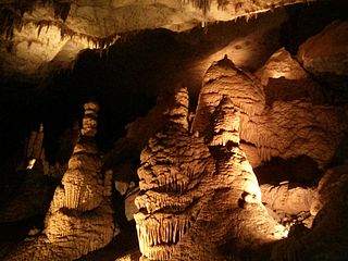
Cumberland Caverns is a national natural landmark and show cave located in McMinnville, Tennessee. It is the second longest cave in Tennessee and makes the list of longest caves in the United States and in the world.

<span class="mw-page-title-main">Big Bone Cave</span>

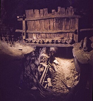
(Big) Bone Cave is a cave located in Van Buren County, Tennessee, in the community of Bone Cave that is named after it. It is notable both for its history and current recreational use. It is listed on the National Register of Historic Places and a designated National Natural Landmark. It is a 400-acre (161.9 ha) State Natural Area managed by Rock Island State Park. It is named for the discovery of the bones of a giant ground sloth in 1811. The cave was operated as a saltpeter mine, notably during the War of 1812 and the American Civil War. A variety of natural remains and human artifacts have been well preserved in the dry atmosphere of the cave. The cave is the 10th longest mapped cave in Tennessee.

<span class="mw-page-title-main">Walden Ridge</span> Mountain in Tennessee, United States

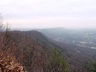
Walden Ridge is a mountain ridge and escarpment located in Tennessee, in the United States. It marks the eastern edge of the Cumberland Plateau and is generally considered part of it. Walden Ridge is about 74 miles (119 km) long, running generally north-south. Its highest point is at Hinch Mountain, which reaches 3,048 feet (929 m) above sea level. Sometimes Walden Ridge is called the Cumberland Escarpment.

<span class="mw-page-title-main">Sequatchie Valley</span>

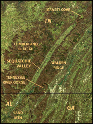
Sequatchie Valley is a relatively long and narrow valley in the U.S. state of Tennessee and, in some definitions, Alabama. It is generally considered to be part of the Cumberland Plateau region of the Appalachian Mountains; it was probably formed by erosion of a compression anticline, rather than rifting process as had been formerly theorized.

<span class="mw-page-title-main">Scott's Gulf</span> Canyon in Tennessee

Scott's Gulf is a canyon situated along the Caney Fork River in White County, Tennessee, in the southeastern United States. The canyon stretches for approximately 18 miles (29 km) as the Caney Fork drops from the top of the Cumberland Plateau down to the eastern Highland Rim. This remote section of the river is home to a wilderness area consisting of a largely undisturbed deciduous forest, numerous waterfalls, caves and other geological formations, and Class IV and Class V whitewater rapids.

<span class="mw-page-title-main">Ozone Falls State Natural Area</span>

Ozone Falls State Natural Area is a state natural area in Cumberland County, Tennessee in the southeastern United States. It consists of 43 acres (0.17 km2) centered on Ozone Falls, a 110-foot (34 m) plunge waterfall, and its immediate gorge along Fall Creek. Because of its picturesque beauty and easy access, Disney selected Ozone Falls for scenes for their live-action film "Rudyard Kipling's The Jungle Book". The area is managed by the Tennessee Department of Environment and Conservation and maintained by Cumberland Mountain State Park. It is also part of Cumberland Trail State Park.

The U.S. state of Tennessee is geographically diverse, with varying terrains and several distinct physiographic regions. Its landforms range from the Blue Ridge Mountains in the eastern part of the state to flat and fertile plains along the Mississippi River. The state is geographically, legally, culturally, and economically divided into three Grand Divisions: East Tennessee, Middle Tennessee, and West Tennessee.

<span class="mw-page-title-main">Cumberland Homesteads</span> United States historic place

Cumberland Homesteads is a community located in Cumberland County, Tennessee, United States. Established by the New Deal-era Division of Subsistence Homesteads in 1934, the community was envisioned by federal planners as a model of cooperative living for the region's distressed farmers, coal miners, and factory workers. While the cooperative experiment failed and the federal government withdrew from the project in the 1940s, the Homesteads community nevertheless survived. In 1988, several hundred of the community's original houses and other buildings, which are characterized by the native "crab orchard" sandstone used in their construction, were added to the National Register of Historic Places as a historic district.

References

  1. Harry Moore, A Geologic Trip Across Tennessee by Interstate 40 (Knoxville, Tenn.: University of Tennessee Press, 1994), 69-70.
  2. Crawford, N.C. (1989). "The karst hydrogeology of the Cumberland Plateau Escarpment of Tennessee (Grassy Cove area)". TN Div. of Geology, Rept. of Investigation #44. 2: 41.
  3. Moore, 237.
  4. Tennessee Cave Survey, "Data Disk." 30 September 2017. Retrieved: 21 December 2017.
  5. Bob Gulden, "NSS U.S.A Long Cave List." 09 August 2017. Retrieved: 21 December 2017.
  6. Dunigan/Sutherland, Tennessee sinkholes 2013
  7. The WPA Guide to Tennessee (Knoxville: University of Tennessee Press, 1986), 500. Originally compiled by the Federal Writers' Project of the Works Project Administration as Tennessee: A Guide to the State, and published in 1939.
  8. Helen Bullard and Joseph Krechniak, Cumberland County's First Hundred Years (Crossville, Tenn.: Centennial Committee, 1956), 126.
  9. Bullard and Krechniak, 126-129.
  10. Matthews, Larry (2014). Caves of Grassy Cove. National Speleological Society. p. 61. ISBN   978-1-879961-49-4.
  11. Bullard and Krechniak, 128-129.
  12. Information obtained from plaque entitled "Legend of Grassy Cove's Petrified Soldier" at the Grassy Cove Community Center, 29 March 2008.
  13. Tennessee Trail Association, "Cumberland Trail - Grassy Cove Segment Archived 2008-05-13 at the Wayback Machine ." Retrieved: 24 June 2008.