South Kalimantan is a province of Indonesia. It is the smallest province in Kalimantan, the Indonesian territory of Borneo. The provincial capital was Banjarmasin until 15 February 2022 when it was legally moved to Banjarbaru. The population of South Kalimantan was recorded at just over 3.625 million people at the 2010 Census, and at 4.07 million at the 2020 Census. The official estimate as at mid 2022 was 4,182,080. One of the five Indonesian provinces in Kalimantan, it is bordered by the Makassar Strait in the east, Central Kalimantan in the west and north, the Java Sea in the south, and East Kalimantan in the north. The province also includes the island of Pulau Laut, located off the eastern coast of Kalimantan. The province is divided into 11 regencies and 2 cities. South Kalimantan is the traditional homeland of the Banjar people, although some parts of East Kalimantan and Central Kalimantan are also included in this criterion. Nevertheless, South Kalimantan, especially the former capital city Banjarmasin has always been the cultural capital of Banjarese culture. Many Banjarese have migrated to other parts of Indonesia, as well as neighbouring countries such as Singapore and Malaysia. In addition, other ethnic groups also inhabit the province, such as several groups of the Dayaks, who mostly live in the interior part of the province, as well as the Javanese, who mostly migrated from Java due to the Transmigration program which dated from the Dutch colonial era.It is one of the provinces in Indonesia that has a larger population than Mongolia.
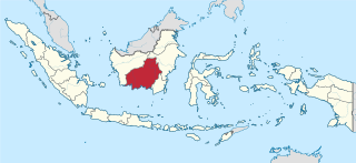
Central Kalimantan is a province of Indonesia. It is one of five provinces in Kalimantan, the Indonesian part of Borneo. It is bordered by West Kalimantan to the west, South Kalimantan and East Kalimantan to the east, Java Sea to the south and is separated narrowly from North Kalimantan and Malaysia by East Kalimantan's Mahakam Ulu Regency. Its provincial capital is Palangka Raya and in 2010 its population was over 2.2 million, while the 2020 Census showed a total of almost 2.67 million; the official estimate as at mid 2023 was 2,774,747.
Kumai is a port in Central Kalimantan province in Indonesia, on the island of Borneo. It lies on the Kumai River.

Telephone numbers in Indonesia have different systems for land lines and mobile phones: land lines use area codes, while mobile phones do not.
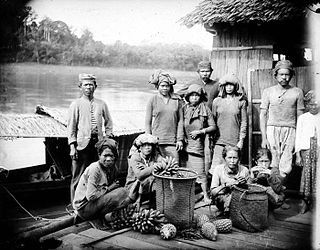
Bakumpai or Baraki are indigenous people of Borneo and are considered as a sub-ethnic group of the Dayak Ngaju people group with Islamic background. The Bakumpai people first occupy along the Barito riverbanks in South Kalimantan and Central Kalimantan, from Marabahan to Puruk Cahu, Murung Raya Regency. The Bakumpai people first appeared as a newly recognized people group in census 2000 and were made up of 7.51% of Central Kalimantan population, which before this the Bakumpai people were considered as part of the Dayak people in a 1930 census.

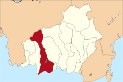
North Barito Regency is one of the thirteen regencies which divide the Central Kalimantan Province on the island of Kalimantan, Indonesia. It originally included much more of the northern part of the province, but on 10 April 2002 the larger northwestern part of the regency was split off to create a new Murung Raya Regency. Muara Teweh is the capital of North Barito Regency, which covers an area of 10,152.25 km2. The population of North Barito Regency was 121,573 at the 2010 Census and 154,812 at the 2020 Census; the official estimate as at mid 2022 was 160,235.

Gunung Mas Regency is one of the thirteen regencies of Central Kalimantan Province, Indonesia. The regency seat is located at the town of Kuala Kurun in Kurun District. The population area of Gunung Mas Regency is 19,894 km2, and its population was 96,990 at the 2010 census and 135,373 at the 2020 census; the official estimate as at mid 2023 was 142,835 . The regency initially existed between 1965 and 1979, after which it was a district within Kapuas Regency. Its status as a separate regency was restored on 10 April 2002 following rapid decentralization and democratization after the fall of Suharto. The regency has the 5th highest Human Development Index in the province.

Kapuas Regency is one of the thirteen regencies which divide Central Kalimantan Province, on the island of Kalimantan, Indonesia. It formerly covered a wider area, but on 10 April 2002 two further regencies were cut out of its western districts, and the residual area is now 17,070.39 km.2 Its population was 329,646 at the 2010 Census and 410,446 at the 2020 Census; the official estimate as at mid 2023 was 425,186. The administrative centre is the town of Kuala Kapuas near the coast, but the largest town is Selat, which includes 8 of the regency's 15 urban kelurahan, and had 72,382 inhabitants in mid 2023.

Katingan Regency is one of the thirteen regencies which comprise the Central Kalimantan Province on the island of Kalimantan (Borneo), Indonesia. It was created on 10 April 2002 from what were previously the eastern districts of East Kotawaringin Regency. The town of Kasongan is the capital of the Regency, which covers an area of 20,382.26 km2. The population of Katingan Regency was 146,439 at the 2010 Census and 162,222 at the 2020 Census; the official estimate as at mid 2023 was 169,355.

West Kotawaringin Regency is one of the thirteen regencies which comprise the Central Kalimantan Province on the island of Kalimantan (Borneo), Indonesia. It originally comprised the whole western part of the province, having been split from a single Kotawaringin Regency on 26 June 1959 into separate regencies for West and East Kotawaringin, but on 10 April 2002 the most westerly districts of West Kotawaringin were split off to form the new Lamandau Regency and Sukamara Regency. The residual West Kotawaringin Regency has a land area of about 10,759 km2, and its population was 235,803 at the 2010 Census and 270,388 at the 2020 Census; the official estimate as at mid 2023 was 279,740. The town of Pangkalan Bun in Arut Selatan District is the capital of West Kotawaringin Regency.

East Kotawaringin Regency is one of the thirteen regencies which comprise the Central Kalimantan Province on the island of Kalimantan (Borneo), Indonesia. It originally covered a much larger part of the province, having been split from a single Kotawaringin Regency on 26 June 1959 into separate regencies for East and West Kotawaringin, but on 10 April 2002 several districts in the west of the regency were split off to form the new Seruyan Regency, and several districts in the east of the regency were similarly split off to form the new Katingan Regency. The area of the residual East Kotawaringin Regency is 16,796 km2, and its population was 374,175 at the 2010 Census, and 428,900 at the 2020 Census; the official estimate as at mid 2023 was 443,359. The town of Sampit is the capital of East Kotawaringin Regency.

Pulang Pisau Regency is one of the thirteen regencies which comprise the Central Kalimantan Province on the island of Kalimantan (Borneo), Indonesia. It was created on 10 April 2002 from what were previously the southwest districts of Kapuas Regency. The town of Pulang Pisau is the capital of Pulang Pisau Regency. The land area of Pulang Pisau Regency is 9,650.86 km2, and its population was 120,062 at the 2010 Census and 134,499 at the 2020 Census; the official estimate as at mid 2023 was 138,119.
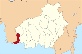
Sukamara Regency is one of the thirteen regencies which comprise the Central Kalimantan Province on the island of Kalimantan (Borneo), Indonesia. It was created on 10 April 2002 from the former southwest part of West Kotawaringin Regency. The town of Sukamara is the capital of Sukamara Regency, which covers an area of 3,827 km2. The population of the Regency was 44,952 at the 2010 Census and 63,464 at the 2020 Census; the official estimate as at mid 2023 was 66,633.
Batamad, abbreviation from Barisan Pertahanan Masyarakat Adat Dayak, is an official paramilitary under National Dayak Customary Council in Indonesia. It was established in February 2012 with approval of Central Kalimantan provincial government based on Regional Law Number 16 of 2008. Initially, it was created as a response of rising religious extremism in Indonesia, including Central Kalimantan, and the paramilitary was tasked to supervise suspicious religious activities there, particularly those allegedly by Islamic extremism. Other than that, the organization is also tasked to enforce customary laws under Dayak culture, enforcing tribal land claims, as well as protecting rights of Dayak people. It is proposed in 2018 by Central Kalimantan province that the organization would also act as a security personnels during tribal courts. However, outside of its given legal authorities, the organization also participate in enforcing road traffic with Indonesian National Police. The organization has been descibred by local media as an "official tribal police".

Pemboewan or Pemboeang was a subdistrict of the Dutch East Indies, located in modern-day Central Kalimantan, Indonesia.
Kuala Pembuang is the capital, administrative center, and economic center of Seruyan Regency, Central Kalimantan, Indonesia. Initially, Kuala Pembuang was a sub-district before being divided into two sub-districts, namely Kuala Pembuang I and Kuala Pembuang II.

Kuala Kapuas is the regency seat of Kapuas Regency and also one of the major towns in Central Kalimantan. This town is at a distance of 137 km northeast of Palangka Raya city, the capital of Central Kalimantan Province. The area of this town is mainly situated within six urban villages (kelurahan) and two rural districts (desa) in the district of Selat i.e. the kelurahan of Selat Barat, Selat Dalam, Selat Tengah, Selat Hulu, Selat Hilir and Selat Utara, and the desa of Pulau Telo, and Pulau Telo Baru. The total population of Kuala Kapuas as of 2019 was approximately 55,573 people