Related Research Articles

The River Severn, at 220 miles (354 km) long, is the longest river in Great Britain. It is also the river with the most voluminous flow of water by far in all of England and Wales, with an average flow rate of 107 m3/s (3,800 cu ft/s) at Apperley, Gloucestershire. It rises in the Cambrian Mountains in mid Wales, at an altitude of 2,001 feet (610 m), on the Plynlimon massif, which lies close to the Ceredigion/Powys border near Llanidloes. The river then flows through Shropshire, Worcestershire and Gloucestershire. The county towns of Shrewsbury, Gloucester and Worcester lie on its course.

South Gloucestershire is a unitary authority area in the ceremonial county of Gloucestershire, South West England. Towns in the area include Yate, Chipping Sodbury, Thornbury, Filton, Patchway and Bradley Stoke. The southern part of its area falls within the Greater Bristol urban area surrounding the city of Bristol.

Avon was a non-metropolitan and ceremonial county in the west of England that existed between 1974 and 1996. The county was named after the River Avon, which flows through the area. It was formed from the county boroughs of Bristol and Bath, together with parts of the administrative counties of Gloucestershire and Somerset.

The Bristol Channel is a major inlet in the island of Great Britain, separating South Wales and South West England. It extends from the smaller Severn Estuary of the River Severn to the North Atlantic Ocean. It takes its name from the English city and port of Bristol

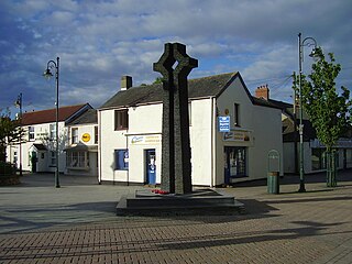
Caldicot is a market town and community in Monmouthshire, Wales. The town is located between Chepstow and the city of Newport. The site adjoins the Caldicot Levels, on the north side of the Severn Estuary. The population of the built-up area was around 11,000. It has a large school, Caldicot School, and is known for its medieval castle. The built-up area includes Portskewett. Caldicot had a population of 9,604 in 2011.

The A403 is a main road linking Bristol with the Severn Estuary. It runs from junction 1 of the M48 at Aust to the docks at Avonmouth. After the Severn Bridge was opened in 1966, the A403 was constructed in 1969 and 1970 to provide a direct route between the M4 motorway and Avonmouth. It is an important route for the local industries, allowing easy access between Wales and this part of England. It was financed by Gloucestershire County Council with a £387,000 grant from the Ministry of Transport and was initially known as the Avonmouth Aust Coast Road.
Severn Beach is a village on the Severn Estuary in South Gloucestershire, England. The eastern portal of the Severn Tunnel is on the outskirts of the village. The Severn footpath – on the sea wall – is part of the Severn Way that leads from Gloucester, Slimbridge and the Second Severn Crossing. Extensive sea defences have been constructed and this provides a popular walkway along its length. Originally, the Severn Way finished at Severn Beach, but it has been extended to Bristol.
Avonmouth is a port and outer suburb of Bristol, England, facing two rivers: the reinforced north bank of the final stage of the Avon which rises at sources in Wiltshire, Gloucestershire and Somerset; and the eastern shore of the Severn Estuary. Strategically the area has been and remains an important part of the region's maritime economy particularly for larger vessels for the unloading and exporting of heavier goods as well as in industry including warehousing, light industry, electrical power and sanitation. The area contains a junction of and is connected to the south by the M5 motorway and other roads, railway tracks and paths to the north, south-east and east.

The Severn Beach line is a local railway line in Bristol and Gloucestershire, England. It runs from Bristol Temple Meads to Severn Beach, and used to extend to Pilning. The first sections of the line were opened in 1863 as part of the Bristol Port Railway and Pier; the section through Bristol was opened in 1875 as the Clifton Extension Railway. The line has faced several threats of closure over the years, and has been reduced to single track in many places. In recent years however it has experienced a surge in passenger numbers, with a 90% increase in the years 2007–11. All services along the line are operated by Great Western Railway, generally two trains per hour in each direction between Temple Meads and Avonmouth, calling at all stations, with one train per hour extended to Severn Beach. The line carries little freight traffic, with most of the heavy freight traffic to Avonmouth Docks being routed via the Henbury Loop Line through Filton. The line has been highlighted by Thomas Cook as one of the scenic lines of Europe.

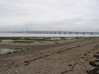
The Severn Estuary is the estuary of the River Severn, flowing into the Bristol Channel between South West England and South Wales. Its very high tidal range, approximately 50 feet (15 m), creates valuable intertidal habitats and has led to the area being at the centre of discussions in the UK regarding renewable tidal energy.

A rhyne (Somerset), rhine/rhyne (Gloucestershire), or reen is a term used in parts of England and Wales for a drainage ditch, or canal, used to turn areas of wetland close to sea level into useful pasture.
Greater Bristol is a term used for the conurbation which contains and surrounds the city of Bristol in the South West of England. There is no official "Greater Bristol" authority, but the term is sometimes used by local, regional and national authorities, and others as a synonym for either the "Bristol Urban Area" or a wider area of the former County of Avon, and by some, TfGB, to refer to the Province of Bristol as defined by C. B. Fawcett (1919) or Derek Senior (1969).

The Severn Barrage is any of a range of ideas for building a barrage from the English coast to the Welsh coast over the Severn tidal estuary. Ideas for damming or barraging the Severn estuary have existed since the 19th century. The building of such a barrage would constitute an engineering project comparable with some of the world's biggest. The purposes of such a project have typically been one or several of: transport links, flood protection, harbour creation, or tidal power generation. In recent decades it is the latter that has grown to be the primary focus for barrage ideas, and the others are now seen as useful side-effects. Following the Severn Tidal Power Feasibility Study (2008–10), the British government concluded that there was no strategic case for building a barrage but to continue to investigate emerging technologies. In June 2013 the Energy and Climate Change Select Committee published its findings after an eight-month study of the arguments for and against the Barrage. MPs said the case for the barrage was unproven. They were not convinced the economic case was strong enough and said the developer, Hafren Power, had failed to answer serious environmental and economic concerns.

Gwent Wildlife Trust (GWT) is a wildlife trust covering the area between the lower Wye and Rhymney rivers which forms the vice county of Monmouthshire in south-east Wales. It is a registered charity and a member of the Wildlife Trusts Partnership.

Portbury Ashlands which is now known as Portbury Wharf Nature Reserve is a nature reserve between Portishead and the Royal Portbury Dock in Somerset, England. It was formed from the redevelopment of the area of Portishead formerly occupied by two power stations. To the east of the harbour, an area known as "the Ashlands" was used for over 50 years to get rid of power station waste which was dumped into lagoons on the site.

The Severnside Community Rail Partnership is a community rail partnership covering the network of routes radiating from Bristol, bounded by Gloucester, Bath/Freshford, Weston-super-Mare, Taunton, and the Severn Estuary. It was founded in 2004, and is principally sponsored by local councils.
Great Western Cities is a collaborative initiative launched in February 2015 by the cities of Bristol, in England, and Cardiff and Newport, in Wales, to improve cooperation in the area as a city region, and to develop economic and environmental partnerships.

The Severnside Sirens are a system of Civil defense sirens located along the South Severn Estuary coastline from Redcliffe Bay to Pilning, northwest of Bristol. They are activated by Avon and Somerset Police in the event of a potential incident at one of the COMAH sites located in the area, mainly in and near Avonmouth. The system was setup in 1997 following a fire at the Albright and Wilson site in 1996.
References
- ↑ "Severnside: A feasibility study". Archived from the original on 21 October 2007. Retrieved 14 December 2007.
- ↑ "Standing Conference on Severnside Local Authorities". Archived from the original on 13 January 2008.
- ↑ "Valuation Tribunal Service".
- ↑ "Welcome to Severnside Community Rail Partnership". Severnside Community Rail Partnership.
- ↑ "Residents protest against stadium plans". 4 January 2004 – via news.bbc.co.uk.
- ↑ "Avon and Somerset Constabulary - Severnside beat". Archived from the original on 17 November 2007.
- ↑ "Severnside Art Club - The premier art club for the Severnside Areas". Archived from the original on 26 October 2007.
- ↑ Severnside Project | Gloucester City Council Online Archived 11 November 2007 at the Wayback Machine
- ↑ "Homes Plus". www.severnsidehousing.co.uk.
- ↑ Severnside Forum Website!
- ↑ "New £2bn airport plan dropped". 16 December 2003 – via news.bbc.co.uk.