
Harpers Ferry is a historic town in Jefferson County, West Virginia, United States, in the lower Shenandoah Valley. The population was 285 at the 2020 census. Situated at the confluence of the Potomac and Shenandoah rivers, where the U.S. states of Maryland, Virginia, and West Virginia meet, it is the easternmost town in West Virginia.

Shenandoah is a town in Page County, Virginia, United States. The population was 2,373 at the 2010 census.
Claiborne is an unincorporated community in Talbot County, Maryland, United States. The village is located on the eastern shore of the Chesapeake Bay near the mouth of the Eastern Bay at 38°50′15″N76°16′40″W, and uses ZIP code 21624. The 2000 U.S. Census listed the population as 147 and the number of homes as 84, slightly down from its 1941 population of 156. Between 1890 and 1930, the village was a busy port for passenger and then automobile ferry service across the Chesapeake Bay, with numerous stores and motels/resorts, including Maple Hall and the Bellfonte Hotel. A post office was added in 1893 and the Protestant Episcopal Church of Claiborne was built in 1898. In 1912, an elementary school and Methodist Church were added. Before 1912, students attended school in nearby McDaniel. The town's first school consisted of the kitchen of the local railroad pavilion, used as a classroom. In 1913, the town became home to the Claiborne Fresh Air Association, Inc., which was formed for the purpose of providing 10 weeks of fresh air and summer vacation for children who had been exposed to tuberculosis. The role of Claiborne as a terminal for cross-Bay ferries was diminished in 1930 when the primary route shifted to Matapeake in Kent Island. It ended altogether in 1938 when the direct connection from Annapolis to Claiborne was terminated and only an auxiliary shuttle between Claiborne and Romancoke on Kent Island remained. This shuttle service ended in 1952, a few months after the opening of the Chesapeake Bay Bridge; thus ending all ferry service to Claiborne after more than six decades.

U.S. Route 340 is a spur route of US 40, and runs from Greenville, Virginia, to Frederick, Maryland. In Virginia, it runs north–south, parallel and east of US 11, from US 11 north of Greenville via Waynesboro, Grottoes, Elkton, Luray, Front Royal, and Berryville to the West Virginia state line. A short separate piece crosses northern Loudoun County on its way from West Virginia to Maryland.
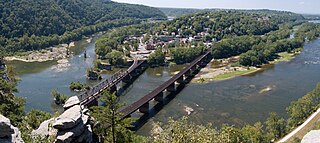
Harpers Ferry National Historical Park, originally Harpers Ferry National Monument, is located at the confluence of the Potomac and Shenandoah rivers in and around Harpers Ferry, West Virginia. The park includes the historic center of Harpers Ferry, notable as a key 19th-century industrial area and as the scene of John Brown's failed abolitionist uprising. It contains the most visited historic site in the state of West Virginia, John Brown's Fort.

John Brown's Fort was initially built in 1848 for use as a guard and fire engine house by the federal Harpers Ferry Armory, in Harpers Ferry, Virginia. An 1848 military report described the building as "An engine and guard-house 35 1/2 x 24 feet, one story brick, covered with slate, and having copper gutters and down spouts…"

Buildings, sites, districts, and objects in Virginia listed on the National Register of Historic Places:
Shannondale is a census-designated place (CDP) in Jefferson County, West Virginia, United States. As of the 2010 census, its population was 3,358.
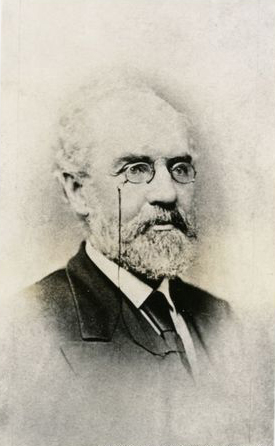
Alexander Robinson Boteler was a nineteenth-century planter turned businessman, as well as artist, writer, lawyer, Confederate officer, philanthropist and politician from Shepherdstown in what was initially Virginia and became West Virginia in the American Civil War.
The city of Winchester, Virginia, and the surrounding area, were the site of numerous battles during the American Civil War, as contending armies strove to control the lower Shenandoah Valley. Winchester changed hands more often than any other Confederate city.
The Manassas Gap Railroad (MGRR) ran from Mount Jackson, Virginia, to the Orange and Alexandria Railroad's Manassas Junction, which later became the city of Manassas, Virginia. Chartered by the Virginia General Assembly in 1850, the MGRR was a 4 ft 8 in narrow gauge line whose 90 completed miles of track included 38 miles (61 km) of 60 pounds-per-yard T-rail and 52 miles (84 km) of 52 pounds-per-yard T-rail. A total of nine locomotives and 232 cars were operated on the line, serving 20 stations.
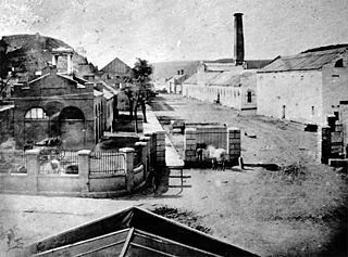
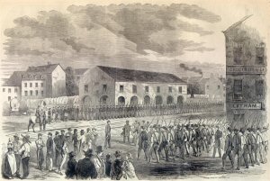
The Harpers Ferry Armory, more formally known as the United States Armory and Arsenal at Harpers Ferry, was the second federal armory created by the United States government; the first was the Springfield Armory. It was located in Harpers Ferry, Virginia, which since 1863 has been part of West Virginia. It was both an arsenal, manufacturing firearms, and an armory, a storehouse for firearms. Along with the Springfield Armory, it was instrumental in the development of machining techniques to make interchangeable parts of precisely the same dimensions.

St. Peter's Roman Catholic Church in Harpers Ferry, West Virginia occupies a prominent location on the heights above Harpers Ferry. The original church was built in 1833 in a pseudo-Gothic style which it kept through the Civil War, the only church in Harpers Ferry to escape destruction during the war. The church was extensively altered in 1896 in the then-popular Neo-Gothic style to produce the church seen today. The church commands a sweeping vista across the gorge of the Shenandoah River above its confluence with the Potomac River. The street along the side of the church building is part of the Appalachian Trail. A short trail leads from the church to Jefferson Rock. St. Peter's Church is a mission church of St. James in Charles Town. A Mass is offered at the historic church Sunday at 9:30 a.m.

The B & O Railroad Potomac River Crossing is a 15-acre (6.1 ha) historic site where a set of railroad bridges, originally built by the Baltimore and Ohio Railroad, span the Potomac River between Sandy Hook, Maryland and Harpers Ferry, West Virginia. The site was added to the National Register of Historic Places on February 14, 1978, for its significance in commerce, engineering, industry, invention, and transportation.

Clermont is a 355-acre (1.44 km2) farm and national historic district located near Berryville, Clarke County, Virginia. The main house was created by Edward Snickers in five parts, beginning in 1756, with additions circa 1770, 1810 and 1840, with a final addition in 1970. The house has an unusual plan with a stair perpendicular to the central hall.

Sweet Springs Resort and spa was founded in Sweet Springs, West Virginia, United States in 1792. Once known as Old Sweet Springs, this historic resort hotel is currently undergoing renovation by the nonprofit Sweet Springs Resort Park Foundation. The property enjoys notoriety for its natural hot spring.

George Rust was Virginia plantation owner, soldier and politician. During the War of 1812, Rust helped defend Baltimore, Maryland, and rose to become a general in the Virginia militia, as well as the civilian superintendent of the arsenal at Harper's Ferry.

The Ottawa Beach Historic District is a residential historic district located on Ottawa Beach Road in Park Township, Ottawa County, Michigan near the outlet of Lake Macatawa. It was listed on the National Register of Historic Places in 1995.
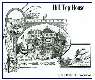
The Hill Top House Hotel is located in Harpers Ferry, West Virginia. It occupies a spectacular location, with panoramic views of the Potomac and Shenandoah valleys.


