Related Research Articles

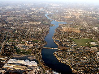
The White River is an American two-forked river that flows through central and southern Indiana and is the main tributary to the Wabash River. Via the west fork, considered to be the main stem of the river by the U.S. Board on Geographic Names, the White River is 362 miles (583 km) long. Indiana's capital, Indianapolis, is located on the river. The two forks meet just north of Petersburg and empty into the Wabash River at Mount Carmel, Illinois.

McCormick's Creek State Park is the oldest state park in the U.S. state of Indiana, dedicated on July 4, 1916, as part of the state's centennial celebration. It is located 14 miles (23 km) west of Bloomington in Owen County. The park receives about 640,000 visitors annually.
The St. Joseph River is a tributary of Lake Michigan with a length of 206 miles (332 km). The river flows in a generally westerly direction through southern Michigan and northern Indiana, United States, to its terminus on the southeast shore of the lake. It drains a primarily rural farming area in the watershed of Lake Michigan. It was enormously important to Native Americans and greatly aided in the colonial exploration, settlement and administration of New France and the nascent United States as a canoe route between Lake Michigan and the watershed of the Mississippi River.
The Indiana Department of Natural Resources (DNR) is the agency of the U.S. state of Indiana. There are many divisions within the DNR and each has a specific role. The DNR is not only responsible for maintaining resource areas but also manages Indiana's fish and wildlife, reclaims coal mine ground, manages forested areas, aids in the management of wildlife on private lands, enforces Indiana's conservation laws, and many other duties not named here. According to the department's website, their mission is "to protect, enhance, preserve, and wisely use natural, cultural, and recreational resources for the benefit of Indiana's citizens through professional leadership, management, and education".

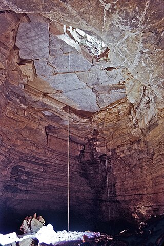
Bluespring Caverns is a cave system located in Lawrence County, Indiana, approximately 80 miles (128 km) south of Indianapolis. The cave system is a karst and river type cave formation and drains a 15 miles² (38.8 km²) sinkhole plain. The cave contains 21 miles (34 km) of surveyed passages and is most notable for having the longest known subterranean river in the United States with approximately 3 miles (4.8 km) of navigable river.

Spring Mill State Park is a 1,358-acre (5 km2) state park in the state of Indiana. The park is located to the south of Bloomington, about 3 miles (5 km) east of the city of Mitchell on Indiana Highway 60. It contains a settler's village, the Gus Grissom Memorial, a nature's center, and campgrounds.

O'Bannon Woods State Park is a 2,000-acre (8 km2) state park in the state of Indiana, 32 miles (51 km) west of Louisville, Kentucky.

Shawnee State Park is a 3,983-acre (1,612 ha) Pennsylvania state park in Juniata and Napier Townships, Bedford County, Pennsylvania in the United States. Shawnee Lake, a 451-acre (183 ha) warm water reservoir, is at the center of the park as its main attraction. The park's main entrance is just east of Schellsburg, along U.S. Route 30 and about 10 miles (16 km) west of the county seat of Bedford. The park is also easily accessed via State Route 31 and by State Route 96.

The Minnesota Department of Natural Resources, or Minnesota DNR, is the agency of the U.S. state of Minnesota charged with conserving and managing the state's natural resources. The agency maintains areas such as state parks, state forests, recreational trails, and recreation areas as well as managing minerals, wildlife, and forestry throughout the state. The agency is divided into six divisions - Ecological & Water Resources, Enforcement, Fish & Wildlife, Forestry, Lands & Minerals, and Parks & Trails.

The Wisconsin Department of Natural Resources (WDNR) is a government agency of the U.S. state of Wisconsin charged with conserving and managing Wisconsin's natural resources. The Wisconsin Natural Resources Board has the authority to set policy for the WDNR. The WDNR is led by the Secretary, who is appointed by the Governor of Wisconsin. The WDNR develops regulations and guidance in accordance with laws passed by the Wisconsin Legislature. It administers wildlife, fish, forests, endangered resources, air, water, waste, and other issues related to natural resources. The central office of the WDNR is located in downtown Madison, near the state capitol.

Twin Caves is a pair of cave entrances connected by a short river at the bottom of a sinkhole within the boundaries of Spring Mill State Park in Lawrence County, Indiana. The river is an exposed section of a mostly-underground stream that originates as Mosquito Creek several miles southeast of the park, which sinks into the Upper Twin Cave system. The stream then comes out briefly at Twin Caves, and flows into the Lower Twin Cave, re-emerging briefly at Bronson Cave shortly to the northwest, then flowing into the Shawnee Cave System. The stream finally emerges at the Donaldson Cave entrance as a short tributary of Mill Creek, still within the park.
The Michigan Department of Natural Resources (DNR) is the agency of the state of Michigan charged with maintaining natural resources such as state parks, state forests, and recreation areas. It is governed by a director appointed by the Governor and accepted by the Natural Resources Commission. Currently the Director is Daniel Eichinger. The DNR has about 1,400 permanent employees, and over 1,600 seasonal employees.

Onondaga Cave State Park is a Missouri state park located on the Meramec River approximately 5 miles (8.0 km) southeast of the village of Leasburg. The park was established in 1982. Park activities include cave tours, camping, fishing, hiking, picnicking, and swimming.

Germany Valley is a scenic upland valley high in the Allegheny Mountains of eastern West Virginia originally settled by German farmers in the mid-18th century. It is today a part of the Spruce Knob–Seneca Rocks National Recreation Area of the Monongahela National Forest, although much ownership of the Valley remains in private hands.
Hellhole is a large and deep pit cave in Germany Valley of eastern West Virginia. It is the seventh longest cave in the United States and is home to almost half of the world's population of Virginia big-eared bats. At 737 feet (225 m), Hellhole is the deepest of several caves in the Valley.

Marshall Township is one of nine townships in Lawrence County, Indiana, United States. As of the 2010 census, its population was 4,660 and it contained 2,038 housing units.
The Lost River is a river that rises in Vernon Township, Washington County, Indiana, and discharges into the East Fork of the White River in Lost River Township, Martin County, Indiana. The river's unusual hydrology has led to two of its features being named as National Natural Landmarks.

Cedarville State Forest is a state forest and protected area in the state of Maryland, near Brandywine, Cedarville, and Waldorf. It offers trails, campsites, a fishing pond, hunting land, and picnic and recreation areas. Trails are available for hikers, bikers and horse riders.

The Blue River is a 57-mile-long (92 km), two-forked stream that runs through Harrison, Crawford and Washington counties in Indiana. The headwaters of the North Fork arise near Salem in Washington County and flow south, and the headwaters of the South Fork arise near New Liberty and flow southwest. The two small forks converge in Fredericksburg. From the confluence, the river flows south until it joins Ohio River in the Harrison-Crawford State Forest, just upstream from Leavenworth.

Cherney Maribel Caves County Park is a county park located near Maribel in Manitowoc County, Wisconsin. The park occupies 75 acres along the West Twin River. Cherney Maribel Caves consists of eleven caves along a rugged cliff line that runs parallel with the West Twin River. Maribel New Hope Cave, Tartarus Cave, Sinkhole Cave and Split Rock Cave are all established gated caves that need guides to visit the entire caves, they are gated due to past vandalism to the Speleothems and protect the current Speleothems.
References
- ↑ "DNR relaxes cave restrictions at two state parks". Indiana Department of Natural Resources. Retrieved 2017-01-22.
Coordinates: 38°43′49.4″N86°24′55.0″W / 38.730389°N 86.415278°W