Sheridan Reserve Center

Last updated

Fort Sheridan Historic District
WikiSheridanTower.jpg
Fort Sheridan water tower and barracks complex
USA Illinois location map.svg
Red pog.svg
Usa edcp location map.svg
Red pog.svg
Location Fort Sheridan, Illinois
Coordinates 42°12′45″N87°48′38″W / 42.21250°N 87.81056°W / 42.21250; -87.81056 Coordinates: 42°12′45″N87°48′38″W / 42.21250°N 87.81056°W / 42.21250; -87.81056
Built1889
ArchitectHolabird & Roche; Office of the Quartermaster General
NRHP reference No. 80001379
Significant dates
Added to NRHPSeptember 29, 1980 [1]
Designated NHLApril 20, 1984 [2]

The Philip H. Sheridan Reserve Center is the former Fort Sheridan now in Lake Forest, Highwood, and Highland Park [3] in Lake County, Illinois, United States. It was originally established as a United States Army Post named after Civil War Cavalry General Philip Sheridan, [4] to honor his services to Chicago. When the main fort was officially closed by the Army on May 3, 1993, [5] the majority of the property was sold by the Department of Defense to commercial land developers. Most of the original housing structures were then refurbished and resold as a residential community. Other buildings were given to cultural organizations like Midwest Young Artists, the largest youth music program in the Midwest. Approximately 90 acres (36 ha) of the southern end of the original post were retained by the Army; there the Army now operates the Sheridan Reserve Center complex.

Contents

In celebration of the 2018 Illinois Bicentennial, Fort Sheridan was selected as one of the Illinois 200 Great Places [6] by the American Institute of Architects Illinois component (AIA Illinois).

History

Looking north on Fort Sheridan in the 1970s. Fort Sheridan From Above.jpg
Looking north on Fort Sheridan in the 1970s.

The Commercial Club of Chicago, concerned since 1877 with the need for a military garrison, was motivated by the Haymarket Riot in 1886 to arrange for the donation of 632 acres (2.6 km²) of land to the Federal Government for this purpose. Troops arrived in November 1887 to what was initially called Camp Highwood. A year later, Camp Highwood was renamed Fort Sheridan. Troops stationed at Fort Sheridan were used in 1894 to quell labor unrest during the Pullman Strike.

In 1888, Ossian Cole Simonds was hired to create a site plan for Fort Sheridan which was to include a parade ground for drills. Simonds used a natural ravine to boarder the meadow created for the purpose. A scenic drive was incorporated into the plan which showcased natural vistas and brick and stone officers' housing. The effect of the plan was lauded as picturesque and charming. [7]

Fort Sheridan became a mobilization and training center beginning with the Spanish–American War in 1898. Following World War I, Fort Sheridan processed nearly 20,000 returning wounded soldiers and helped them return to civilian life through physical and occupational training reenter the workforce. [8] During World War II, over 500,000 men and women were processed through military service. Many army officers who later became famous lived there, including George Patton and Jonathan Wainwright. The 174th Military Police Battalion of the Leavenworth, Kansas National Guard was stationed there in 1950. Fort Sheridan served as the base for supplying and servicing Nike antimissile systems in the upper Midwest from 1953 to 1973, at which point it returned to providing administrative and logistical support services.

The 94 buildings in the Historic District, built between 1889 and 1910, include 64 structures that were the first major works of the architectural firm Holabird & Roche of Chicago. These earliest buildings are made of bricks molded and fired on site, using clay mined from lakefront bluffs. The water tower, originally the tallest structure in the Chicago area, was altered and shortened by 60 feet (18 m) in 1940. The row of buildings flanking the tower were troop barracks. The 110 acre (450,000 m²) Historic District, placed on the National Register of Historic Places in 1980, was designated a National Historic Landmark in 1984. In 1979, the site was documented by the Library of Congress Historic American Buildings Survey.

In 1979, director Robert Redford used a warehouse on the base to build interior sets for his Oscar-winning film Ordinary People.

Fort Sheridan closed in 1993. The decision to close Fort Sheridan came in the 1989 first round of base closings under the Base Realignment and Closure Act (BRAC).

An Army Reserve base continues to use about 90 acres (360,000 m2) of the original Post. The remaining property is divided between the Lake County Forest Preserves, a residential development, a Navy family housing development for personnel of nearby Great Lakes and a variety of ongoing commercial developments. [9]

Environmental concerns

The geological setting of Fort Sheridan is tableland above a 70-foot (21 m) high bluff [10] in an area cut by seven deep ravines. The bluff overlooks Lake Michigan and the ravines create an open face in the bluff at the beach's edge. Over the years, the Army filled in the ravines with waste generated by military operations. The most toxic waste was placed in the Wells Ravine, also known as Landfill 7. The United States Environmental Protection Agency considers Landfill 7 to be a Superfund National Priorities List (NPL) location. [11] The landfills were not operated in an environmentally sound manner. [12] An IEPA permit was not issued while the landfill was operating, and a high-density plastic containment liner was not used between the ravine and the waste. Regulatory oversight did not begin until 1979 when the State of Illinois commenced litigation. An operating permit was issued two months after the landfill ceased operations. [13] The Army then applied for a closure permit, installed a leachate collection system, and placed a clay cap over Landfill 7. By 1982, the cap had failed due to ponding of water and the failure of the leachate collection system to collect leachate. The Army stated that the cap failure was caused by failure to maintain the cap.

By 1989, Fort Sheridan was facing potential closure by the Base Realignment and Closure commission. The Army began evaluating the permanent closure of Landfill 7 and the inherent problems with its maintenance. Because Landfill 7 had been dispensing 14,000 gallons of leachate per day into Lake Michigan, and the leachate was above state environmental effluent standards, CERCLA allowed the Army to implement an interim remedy prior to deciding on a permanent remedy. The Army chose to construct a $16 million cap. [14] Public comments for this interim action opposed the cap, [15] focusing on the Army's characterization of the type of waste in the landfill, the geologic instability of the ravine and bluff environment, and the proximity to Lake Michigan from which local drinking water is drawn. The Army responded that the cap was an interim solution that was thought to be effective for temporary containment of the waste.[ citation needed ]

After the interim containment remedy was selected on April 22, 1997, [16] the Army brought in Dr. Shabica to evaluate the shore protections as part of the design phase. On December 2, 1997, he informed the Army that the cap, as designed, would fail due to erosion. The Army responded by purchasing a new system designed by Dr. Shabica's company. [17] The interim cap was completed in June 2004, and the Army may propose making capping the final remedy based on the same analysis that supported the interim action. [18]

The decision to cap Landfill 7 as the final remedy conflicts with some of the recommendations of the geological community.[ citation needed ] The Army is the lead agency in determining cleanup alternatives. Opponents claim the Analysis of Alternatives found in the remedial investigation, remedial action, and feasibility study was skewed in favor of the Army's preferred remedy which was less expensive. [19] According to the FY2006 Defense Environmental Restoration Program Annual Report To Congress, $58.7 million in cleanup funding had been appropriated for Fort Sheridan. Estimated cost to completion was $22.2 million estimated for FY2003. [20]

Related Research Articles

Highwood, Illinois City in Illinois, United States

Highwood is a North Shore suburb of Chicago in Moraine Township, Lake County, Illinois, United States. As of the 2020 census, the population was 5,074. It is known for its entertainment, restaurants, bars, and festivals.

Naval Air Station Glenview

Naval Air Station Glenview or NAS Glenview was an operational U.S. Naval Air Station from 1923 to 1995. Located in Glenview, Illinois, a suburb of Chicago, the air base primarily operated training aircraft as well as seaplanes on nearby Lake Michigan during World War II. Reconfigured as a Naval Air Reserve base following World War II, NAS Glenview supported Naval Air Reserve, Marine Air Reserve/4th Marine Aircraft Wing, and U.S. Army Reserve 244th Aviation Group as well as an active duty Coast Guard Air Station.

Fort Sheridan is a residential neighborhood within the cities of Lake Forest, Highwood, and Highland Park in Lake County, Illinois, United States. It was originally established as Fort Sheridan, an Army post named after Civil War cavalry general Philip Sheridan, to honor his services to Chicago.

North Shore (Chicago) Many affluent suburbs north of Chicago, Illinois

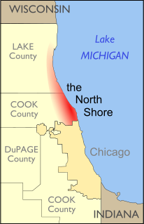
The North Shore consists of many affluent suburbs north of Chicago, Illinois, bordering the shore of Lake Michigan. These communities fall within suburban Cook County and Lake County. The North Shore's membership is often a topic of debate, and it includes some Chicago suburbs which do not border Lake Michigan. However, Evanston, Wilmette, Kenilworth, Winnetka, Glencoe, Highland Park, Highwood, Lake Forest, and Lake Bluff are the main constituents of the North Shore.

Lake Calumet Body of water

Lake Calumet is the largest body of water within the city of Chicago. Formerly a shallow, postglacial lake draining into Lake Michigan, it has been changed beyond recognition by industrial redevelopment and decay. Parts of the lake have been dredged, and other parts reshaped by landfill. Together with the rest of the city of Chicago, the remnant of the lake now drains into the Des Plaines River and the Mississippi River basin via the Cal-Sag Channel and the Chicago Sanitary and Ship Canal.

Warren County PCB Landfill was a PCB landfill located in Warren County, North Carolina, near the community of Afton south of Warrenton. The landfill was created in 1982 by the State of North Carolina as a place to dump contaminated soil as result of an illegal PCB dumping incident. The site, which is about 150 acres (0.61 km2), was extremely controversial and led to years of lawsuits. Warren County was one of the first cases of environmental justice in the United States and set a legal precedent for other environmental justice cases. The site was approximately three miles south of Warrenton. The State of North Carolina owned about 19 acres (77,000 m2) of the tract where the landfill was located, and Warren County owned the surrounding acreage around the borders.

Sheridan Road is a major north-south street that leads from Diversey Parkway in Chicago, Illinois, north to the Illinois-Wisconsin border and beyond to Racine. Throughout most of its run, it is the easternmost north-south through street, closest to Lake Michigan. From Chicago, it passes through Chicago's wealthy lakeside North Shore suburbs, and then Waukegan and Zion, until it reaches the Illinois-Wisconsin state line in Winthrop Harbor. In Wisconsin, the road leads north through Pleasant Prairie and Kenosha, until it ends on the south side of Racine, in Mount Pleasant.

Lake Ontario Ordnance Works Military installation in Niagara County, New York

The former Lake Ontario Ordnance Works (LOOW) was a 7,500-acre (3,000 ha) military installation located in Niagara County, New York, United States, approximately 9.6 mi (15.4 km) north of Niagara Falls.

Sai Tso Wan Recreation Ground

Sai Tso Wan Recreation Ground is a multi-purpose playground in Sai Tso Wan, Hong Kong. It is the first permanent recreational facility in Hong Kong built on a landfill.

Keele Valley landfill

The Keele Valley landfill was the largest landfill in Canada and the third largest in North America during its operation. It was the primary landfill site for the City of Toronto and the regional municipalities of York and Durham from 1983 until 2002, and was owned and operated by the City of Toronto. It was located at the intersection of Keele Street and McNaughton Road in Maple, a community in the northeastern part of the City of Vaughan in Ontario.

The Laurel Park, Inc. site, also known as Hunters Mountain Dump, or Murtha's Dump to locals, is a capped landfill that occupies approximately 20 acres (81,000 m2) of a 35-acre (140,000 m2) parcel of land in Naugatuck, Connecticut. The landfill has been in existence since the late 1940s, and several industries disposed of solvents, oils, hydrocarbons, chemical and liquid sludge, chemical solids, tires, and rubber products there. The facility continued to operate as a municipal landfill until 1987. It was owned and operated by Terrence and Howard Murtha.

Oyster Point Marina/Park

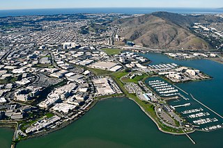
Oyster Point Marina/Park is a 408-berth public marina and 33-acre (13 ha) park located in the city of South San Francisco, California on the western shoreline of San Francisco Bay.

Landfills in the United States American landfills

Municipal solid waste (MSW) – more commonly known as trash or garbage – consists of everyday items people use and then throw away, such as product packaging, grass clippings, furniture, clothing, bottles, food scraps and papers. In 2018, Americans generated about 292.4 million short tons (265.3 Mt) of trash. In the United States, landfills are regulated by the Environmental Protection Agency (EPA) and the states' environmental agencies. Municipal solid waste landfills (MSWLF) are required to be designed to protect the environment from contaminants that may be present in the solid waste stream.

The Waste Disposal Inc. Superfund site Waste disposal

The Waste Disposal Inc. Superfund site is an oil-related contaminated site in the highly industrialized city of Santa Fe Springs in Los Angeles County, California. It is approximately 38 acres (15 ha), with St Paul's high school immediately adjacent to the northeast corner of the site. Approximately 15,000 residents of Santa Fe Springs obtain drinking water from wells within three miles (4.8 km) of the site.

West Lake Landfill EPA superfund site in Missouri, US

West Lake Landfill is a closed, unlined mixed-waste landfill located in Bridgeton, Missouri. It was featured in the 2015 documentaries The First Secret City, The Safe Side of the Fence and the 2017 HBO documentary Atomic Homefront. Its contents have been shown to include radioactive waste; it is thus also an EPA Superfund cleanup site.

Openlands is a non-profit conservation organization and accredited land trust that works with groups and individuals in northeastern Illinois, northwestern Indiana, and southeastern Wisconsin to preserve open space, develop walking and biking trails, restore natural areas, and connect people to the outdoors. Openlands has protected and expanded public access to more than 55,000 acres of land for parks, forest preserves, land and water greenway corridors, and urban gardens across the Chicago metropolitan region. It is a member of Chicago Wilderness.

Grand Calumet River River in Illinois, United States

The Grand Calumet River is a 13.0-mile-long (20.9 km) river that flows primarily into Lake Michigan. Originating in Miller Beach in Gary, it flows through the cities of Gary, East Chicago and Hammond, as well as Calumet City and Burnham on the Illinois side. The majority of the river's flow drains into Lake Michigan via the Indiana Harbor and Ship Canal, sending about 1,500 cubic feet (42 m3) per second of water into the lake. A smaller part of the flow, at the river's western end, enters the Calumet River and ultimately drains into the Illinois and ultimately the Mississippi River.

Ravine Park Community park located in Lake Bluff, Illinois, USA

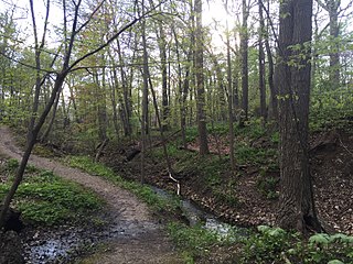
Ravine Park is a community park located in Lake Bluff, Illinois. Measuring roughly 14 acres (5.7 ha) in area, it is dominated by a ravine formed by an ephemeral stream that flows after heavy rainfall and consists of a series of muddy ponds otherwise. The park's main attraction is a small system of nature trails. Ravine Park is one of the only officially protected ravines in all of Lake County, Illinois and offers a refuge for nature in the densely inhabited suburbs of Chicago.

Forest Waste Products is a 120-acre (49-hectare) Superfund site in Forest Township northwest of Otisville, Michigan.

Ordot Dump Former landfill on the Pacific island of Guam

Ordot Dump, also known as Ordot Landfill, was a landfill on the western Pacific island of Guam that operated from the 1940s until 2011. Originally operated by the U.S. military, ownership was transferred to the Government of Guam in 1950, though it continued to receive all waste on the island, including from Naval Base Guam and Andersen Air Force Base, through the 1970s. The Environmental Protection Agency (EPA) designated Ordot Dump a Superfund site in 1983. In 2002, the U.S. government sued Guam under the Clean Water Act to force it to clean up Ordot Dump, resulting in Guam entering into a consent decree to close and cover the dump. After Guam failed to do so, the EPA put the landfill into receivership. The receiver closed Ordot Dump in 2011. In 2017, Guam sued the U.S. government for part of the costs of cleaning up the dump, which were estimated to range as high as $160 million. The Federal government argued that the statute of limitations had already run out for Guam to file suit. The Supreme Court of the United States heard the case, Guam v. United States, and decided unanimously in May 2021 to allow Guam's case to continue.

References

  1. "National Register Information System". National Register of Historic Places . National Park Service. January 23, 2007.
  2. "Fort Sheridan Historic District". National Historic Landmark summary listing. National Park Service. Retrieved October 3, 2007.
  3. "Home". fortsheridan.com.
  4. Gannett, Henry (1905). The Origin of Certain Place Names in the United States. Govt. Print. Off. pp.  129.
  5. The Town of Fort Sheridan, IL - About Fort Sheridan
  6. Waldinger, Mike (January 30, 2018). "The proud history of architecture in Illinois". Springfield Business Journal. Retrieved January 30, 2018.
  7. Tishler, William H. (2004). Midwestern Landscape Architecture. University of Illinois Press. ISBN   9780252072147.
  8. "The Reawakening", 1919
  9. Fort Sheridan
  10. Illinois Department of Transportation; Division of Water Resources. Harmony with the Lake: Guide to Bluff Stabilization, Lake Michigan, IL. The Illinois Coastal Zone Management Program.
  11. US EPA Region 5 Superfund Division, Fort Sheridan.
  12. Argonne National Laboratory. Enhanced Preliminary Assessment Report: Fort Sheridan 1989 pg. 24.
  13. Id at 13, 24.
  14. Walsh, Don and Liberman, Polina, Fort Sheridan Landfills 6 & 7 Closure. Department of Civil & Environmental Engineering, Northwestern University on behalf of Chicago Environmental Law Clinic August 2003 pg 26. Northwestern University study.
  15. Responsiveness Summary. Mayor Geraci of Highland Park, Mayor Sirotti of Highwood, the League of Women Voters of Lake Forest/Lake Bluff/Highland Park, the Lake Michigan Federation, and the Sierra Club all opposed the interim capping action.
  16. USACE, Decision Document (DD) for Interim Source Control Action for Landfills 6 and 7 at Fort Sheridan, Illinois. April 22, 1997.
  17. Shabica, Charles W. and Charles Shabica & Associates. Review of Erosion Control Features for Interim Remedial Action Landfills 6 & 7, Fort Sheridan, Illinois, November 25, 1997.
  18. Microsoft Word - Proposed Plan Landfills 6 & 7 Final Remedy Final.doc
  19. Walsh, Don and Liberman, Polina, Fort Sheridan Landfills 6 & 7 Closure. Department of Civil & Environmental Engineering, Northwestern University on behalf of Chicago Environmental Law Clinic August 2003 pg 26.
  20. Defense Environmental Restoration Program Annual Report To Congress FY2006, page 84.

Further reading