Shickley, Nebraska

Last updated

Shickley, Nebraska
Shickley, Nebraska downtown 1.jpg
Downtown Shickley
Fillmore County Nebraska Incorporated and Unincorporated areas Shickley Highlighted.svg
Location of Shickley, Nebraska
USA Nebraska relief location map.svg
Red pog.svg
Shickley
Location within Nebraska
Usa edcp relief location map.png
Red pog.svg
Shickley
Location within the United States
Coordinates: 40°24′59″N97°43′27″W / 40.41639°N 97.72417°W / 40.41639; -97.72417
Country United States
State Nebraska
County Fillmore
Township Bryant
Area
[1]
  Total0.31 sq mi (0.79 km2)
  Land0.31 sq mi (0.79 km2)
  Water0.00 sq mi (0.00 km2)
Elevation
[2]
1,650 ft (500 m)
Population
 (2020) [3]
  Total343
  Estimate 
(2021) [3]
343
  Density1,100/sq mi (430/km2)
Time zone UTC-6 (Central (CST))
  Summer (DST) UTC-5 (CDT)
ZIP code
68436
Area code 402
FIPS code 31-45085 [4]
GNIS feature ID2399807 [2]

Shickley is a village in Fillmore County, Nebraska, United States. The population was 343 at the 2020 census. [3]

Contents

History

Shickley was established in the 1880s when the Burlington and Missouri River Railroad was extended to that point. [5]

Geography

According to the United States Census Bureau, the village has a total area of 0.30 square miles (0.78 km2), all land. [6]

Demographics

Historical population
CensusPop.Note
1890 307
1900 37221.2%
1910 42915.3%
1920 396−7.7%
1930 389−1.8%
1940 342−12.1%
1950 316−7.6%
1960 37117.4%
1970 3853.8%
1980 4137.3%
1990 360−12.8%
2000 3764.4%
2010 341−9.3%
2020 3471.8%
2021 (est.)343 [3] −1.2%
U.S. Decennial Census [7]

2010 census

As of the census [8] of 2010, there were 341 people, 152 households, and 102 families living in the village. The population density was 1,136.7 inhabitants per square mile (438.9/km2). There were 163 housing units at an average density of 543.3 per square mile (209.8/km2). The racial makeup of the village was 98.5% White, 0.3% African American, 0.3% from other races, and 0.9% from two or more races. Hispanic or Latino of any race were 0.6% of the population.

There were 152 households, of which 22.4% had children under the age of 18 living with them, 60.5% were married couples living together, 4.6% had a female householder with no husband present, 2.0% had a male householder with no wife present, and 32.9% were non-families. 29.6% of all households were made up of individuals, and 18.4% had someone living alone who was 65 years of age or older. The average household size was 2.24 and the average family size was 2.79.

The median age in the village was 47.9 years. 20.2% of residents were under the age of 18; 5.4% were between the ages of 18 and 24; 19.4% were from 25 to 44; 30.8% were from 45 to 64; and 24.3% were 65 years of age or older. The gender makeup of the village was 49.3% male and 50.7% female.

2000 census

As of the census [4] of 2000, there were 376 people, 154 households, and 111 families living in the village. The population density was 1,280.2 inhabitants per square mile (494.3/km2). There were 170 housing units at an average density of 578.8 per square mile (223.5/km2). The racial makeup of the village was 97.87% White, 0.27% African American, 0.27% Pacific Islander, 1.33% from other races, and 0.27% from two or more races. Hispanic or Latino of any race were 1.60% of the population.

There were 154 households, out of which 35.1% had children under the age of 18 living with them, 65.6% were married couples living together, 3.2% had a female householder with no husband present, and 27.9% were non-families. 24.7% of all households were made up of individuals, and 16.9% had someone living alone who was 65 years of age or older. The average household size was 2.44 and the average family size was 2.92.

In the village, the population was spread out, with 26.6% under the age of 18, 5.1% from 18 to 24, 24.2% from 25 to 44, 22.3% from 45 to 64, and 21.8% who were 65 years of age or older. The median age was 42 years. For every 100 females, there were 104.3 males. For every 100 females age 18 and over, there were 101.5 males.

As of 2000 the median income for a household in the village was $43,125, and the median income for a family was $49,750. Males had a median income of $36,875 versus $20,000 for females. The per capita income for the village was $19,257. About 0.9% of families and 3.2% of the population were below the poverty line, including 3.2% of those under age 18 and 1.3% of those age 65 or over.

Related Research Articles

<span class="mw-page-title-main">Rothbury, Michigan</span> Village in Michigan, United States

Rothbury is a village in Grant Township, Oceana County in the U.S. state of Michigan. The population was 486 at the 2010 census.

<span class="mw-page-title-main">Grantwood Village, Missouri</span> Town in Missouri, United States

Grantwood Village is a town in St. Louis County, Missouri, United States. The population was 863 at the 2010 census.

<span class="mw-page-title-main">Sycamore Hills, Missouri</span> Village in Missouri, United States

Sycamore Hills is a village in St. Louis County, Missouri, United States. The population is 560 at the 2020 census.

<span class="mw-page-title-main">Westwood, Missouri</span> Village in Missouri, United States

Westwood is a village in west St. Louis County, Missouri, United States. The population was 316 at the 2020 census.

<span class="mw-page-title-main">Greenwood, Nebraska</span> Village in Nebraska, United States

Greenwood is a village in northwest Cass County, Nebraska, United States. The population was 595 at the 2020 census.

<span class="mw-page-title-main">Waterloo, Nebraska</span> Village in Douglas County, Nebraska, United States

Waterloo is a village in Douglas County, Nebraska, United States. The population was 935 at the 2020 census.

<span class="mw-page-title-main">Hanley Hills, Missouri</span> Village in Missouri, United States

Hanley Hills is a village in St. Louis County, Missouri, United States. The population was 2,101 at the 2010 census.

<span class="mw-page-title-main">North Kingsville, Ohio</span> Village in Ohio, United States

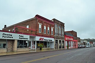
North Kingsville is a village in Ashtabula County, Ohio, United States. The population was 2,742 at the 2020 census.

<span class="mw-page-title-main">Wayne Lakes, Ohio</span> Village in Ohio, United States

Wayne Lakes is a village in Darke County, Ohio, United States. The population was 693 at the 2020 census.

<span class="mw-page-title-main">Addyston, Ohio</span> Village in Ohio, United States

Addyston is a village in Miami Township, Hamilton County, Ohio, United States. Located along the Ohio River, it is a western suburb of the neighboring city of Cincinnati. The population was 927 at the 2020 census.

<span class="mw-page-title-main">Cleves, Ohio</span> City in Ohio, United States

Cleves is a village in Miami Township, Hamilton County, Ohio, United States. Located along the Ohio River, it is a western suburb of Cincinnati. The population was 3,414 at the 2020 census.

<span class="mw-page-title-main">Bethlehem, West Virginia</span> Village in West Virginia, United States

Bethlehem is a village in Ohio County, West Virginia, United States. It is part of the Wheeling, West Virginia Metropolitan Statistical Area. The population was 2,499 at the 2010 census.

<span class="mw-page-title-main">Bellevue, Wisconsin</span> Village in Wisconsin, United States

Bellevue is a village in Brown County, Wisconsin. It was a town until incorporating as a village on February 14, 2003. The population was 15,935 at the time of the 2020 census. Bellevue is part of the Green Bay metropolitan area. Bellevue sits around 4.34 miles (6.99 km) east from central Green Bay.

<span class="mw-page-title-main">Monticello, Green County, Wisconsin</span> Village in Wisconsin, United States

Monticello is a village in Green County, Wisconsin, United States. The population was 1,217 as of the 2010 census.

<span class="mw-page-title-main">Avoca, Wisconsin</span> Village in Wisconsin, United States

Avoca is a village in Iowa County, Wisconsin, United States. The population was 637 at the 2010 census. It is part of the Madison Metropolitan Statistical Area. It is named after Avoca in Ireland.

<span class="mw-page-title-main">Cecil, Wisconsin</span> Village in Wisconsin, United States

Cecil is a village in Shawano County, Wisconsin, United States. The population was 529 at the 2020 census.

<span class="mw-page-title-main">Wilson, Ohio</span> Village in Ohio, United States

Wilson is a village in Belmont and Monroe counties in the U.S. state of Ohio. The population was 129 at the 2020 census. It is part of the Wheeling metropolitan area.

<span class="mw-page-title-main">Dorchester, Wisconsin</span> Village in Wisconsin, United States

Dorchester is a village in Clark and Marathon counties in the U.S. state of Wisconsin, along the 45th parallel. It is part of the Wausau, Wisconsin Metropolitan Statistical Area. The population was 876 at the 2010 census. Of this, 871 were in Clark County, and only 5 were in Marathon County.

<span class="mw-page-title-main">Dallas, Wisconsin</span> Village in Wisconsin, United States

Dallas is a village in Barron County in the U.S. state of Wisconsin. The population was 409 at the 2010 census. The village is located within the Town of Dallas.

<span class="mw-page-title-main">Bloomington, Wisconsin</span> Village in Wisconsin, United States

Bloomington is a village in Grant County, Wisconsin, United States. The population was 735 as of the 2010 census. The village is located within the Town of Bloomington.

References

  1. "ArcGIS REST Services Directory". United States Census Bureau. Retrieved September 18, 2022.
  2. 1 2 U.S. Geological Survey Geographic Names Information System: Shickley, Nebraska
  3. 1 2 3 4 Bureau, US Census. "City and Town Population Totals: 2020—2021". Census.gov. US Census Bureau. Retrieved October 20, 2022.
  4. 1 2 "U.S. Census website". United States Census Bureau . Retrieved January 31, 2008.
  5. "Shickley, Fillmore County". Center for Advanced Land Management Information Technologies. University of Nebraska. Retrieved August 8, 2014.
  6. "US Gazetteer files 2010". United States Census Bureau. Archived from the original on January 25, 2012. Retrieved June 24, 2012.
  7. "Census of Population and Housing". Census.gov. Retrieved June 4, 2015.
  8. "U.S. Census website". United States Census Bureau . Retrieved June 24, 2012.