Related Research Articles

Baker County is a county in the U.S. state of Florida. As of the 2020 census, the population was 28,259. Its county seat is Macclenny. The county was founded in 1861 and is named for James McNair Baker, a judge and Confederate Senator.

Martin County is a county in the U.S. state of Indiana. As of the 2020 United States Census, the population was 9,812. The county seat is Shoals at the center of the county, and the county's only incorporated city is Loogootee, on the county's western border.

Muscle Shoals is the largest city in Colbert County, Alabama. It is located on the left bank of the Tennessee River in the northern part of the state and, as of the 2010 census, its population was 13,146. The estimated population in 2019 was 14,575.

Crestview is a city in Okaloosa County, Florida, United States. The population was 27,134 at the 2020 census, up from 20,978 at the 2010 census. It is the county seat of Okaloosa County. With an elevation of 235 feet (72 m) above sea level, it is one of the highest points in the state; it receives 65 inches (1,700 mm) of rainfall annually, the second-most of any city in the state of Florida, after Fort Walton Beach with 69 inches.
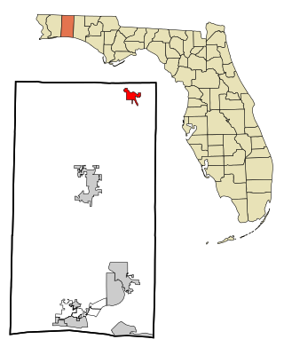
Laurel Hill is a city in Okaloosa County, Florida, United States. The population was 537 at the 2010 census. It is part of the Fort Walton Beach–Crestview–Destin Metropolitan Statistical Area.

Piedmont is a census-designated place (CDP) along the Saluda River in Anderson and Greenville counties in the U.S. state of South Carolina. The population was 5,411 at the 2020 census.

The Door Peninsula is a peninsula in eastern Wisconsin, separating the southern part of the Green Bay from Lake Michigan. The peninsula includes northern Kewaunee County, northeastern Brown County, and the mainland portion of Door County. It is on the western side of the Niagara Escarpment. Well known for its cherry and apple orchards, the Door Peninsula is a popular tourism destination. With the 1881 completion of the Sturgeon Bay Ship Canal, the northern half of the peninsula became an island.

The East Bay River in Florida is a 15-mile-long (24 km) river located in Santa Rosa and Okaloosa counties. It flows from east to west, forming near Hurlburt Field, and empties into the eastern portion of East Bay (Florida) near the towns Holley and Navarre. The river forms part of the southern boundary of Eglin Air Force Base.

PSLelia was a steamship built in 1864, during the American Civil War for use as a blockade runner for the Confederate States of America. She sank in Liverpool Bay in 1865 in an incident that caused 46 fatalities.

The Aucilla River rises in Brooks County, Georgia, USA, close to Thomasville, and passes through the Big Bend region of Florida, emptying into the Gulf of Mexico at Apalachee Bay. Some early maps called it the Ocilla River. It is 89 miles (143 km) long and has a drainage basin of 747 square miles (1,930 km2). Tributaries include the Little Aucilla and Wacissa Rivers. In Florida, the Aucilla River forms the eastern border of Jefferson County, separating it from Madison County on the northern part, and from Taylor County to the south.

The Withlacoochee River or Crooked River is a river in central Florida, in the United States. It originates in the Green Swamp, east of Polk City, flowing west, then north, then northwest and finally west again before emptying into the Gulf of Mexico near Yankeetown. The river is 141 miles (227 km) long and has a drainage basin of 1,170 square miles (3,000 km2). It is believed to have been named after the Withlacoochee River in the northern part of the state, near the border with Georgia.
The Econlockhatchee River is an 54.5-mile-long (87.7 km) north-flowing blackwater tributary of the St. Johns River. The Econ River flows through Osceola, Orange, and Seminole counties in Central Florida, just east of the Orlando Metropolitan Area. It is a designated Outstanding Florida Waters.

Center Township is one of six townships in Martin County, Indiana, United States. As of the 2010 census, its population was 1,654 and it contained 811 housing units.

Lost River Township is one of six townships in Martin County, Indiana, United States. As of the 2010 census, its population was 572 and it contained 265 housing units.

The Suwannee River Water Management District (SRWMD) is responsible for managing groundwater and surface water resources in a 15-county region in north-central Florida, United States. It is the smallest of five Florida water management districts. Its district headquarters are in Live Oak, Florida.
Mossy Head is an unincorporated community in Walton County, Florida, located at the intersection of U.S. Highway 90 and County Road 1087, 2 miles (3.2 km) east of the north end of State Road 285. It is at the head of Mossy Head Branch, a tributary of the Shoal River. The ZIP Code for Mossy Head is 32434.
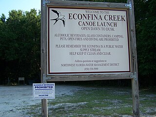
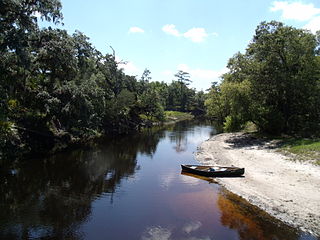
Econfina Creek is a small river in the middle Florida Panhandle. It flows through hilly country, and has sections of whitewater rapids. Much of its flow comes from springs. The river ends at Deer Point Lake, a reservoir that provides the freshwater supply for Panama City and much of Bay County.

Crooked River is a waterway in Franklin County, Florida, that connects the tidal estuary of the Ochlockonee River to a junction with the tidal Carrabelle River and the New River above the town of Carrabelle, Florida. The Crooked River channel is 41 kilometres (25 mi) long, while its ends are 24 kilometres (15 mi) apart.
The Blackwater River Correctional Facility is a private state prison for men located in Milton, Santa Rosa County, Florida, which was opened in 2010 by the GEO Group under contract with the Florida Department of Corrections. This facility houses about 2,000 inmates at a variety of security levels.
Santa Rosa Correctional Institution is a state prison for men located in Milton, Santa Rosa County, Florida, United States, owned and operated by the Florida Department of Corrections. The facility opened in 1996 with a mix of security levels and a capacity of 1,614. It is often considered one of the "toughest" and "most dangerous" prisons in the state of Florida.
References
- ↑ "Shoal River". Geographic Names Information System . United States Geological Survey, United States Department of the Interior . Retrieved February 12, 2021.
- ↑ "Shoal River Guide" (PDF). Florida Department of Environmental Protection. Retrieved January 15, 2021.
- ↑ "Shoal River. Paddling in the Florida Panhandle". PaddleFlorida.net. Retrieved January 15, 2021.
30°41′09″N86°38′53″W / 30.6857°N 86.6480°W