León, officially León de Los Aldama, is the most populous city and municipal seat of the municipality of León in the Mexican state of Guanajuato. In the 2020 Intercensal Survey, INEGI reported 1,721,626 people living in the municipality of León, making it the fourth-most populous municipality in Mexico. The metropolitan area of León recorded a population of 2,140,094 in the 2020 state Census, making it the seventh most populous metropolitan area in Mexico. León is part of the macroregion of Bajío within the Central Mexican Plateau.

Guanajuato, officially the Free and Sovereign State of Guanajuato, is one of the 32 states that make up the Federal Entities of Mexico. It is divided into 46 municipalities and its capital city is Guanajuato.

León/Bajio International Airport ; officially Aeropuerto Internacional de Guanajuato, is an international airport situated in Silao, Guanajuato, Mexico. It is the main international airport serving the Greater León Metropolitan Area and the State of Guanajuato, which is home to a population of 6 million residents, including the cities of Celaya, Guanajuato, Irapuato, Salamanca, and San Miguel de Allende. In addition to offering domestic flights within Mexico, it serves as a gateway for international travel, connecting Central Mexico to various destinations in the United States. It serves as a focus city for Volaris and supports flight training, cargo, logistics and general aviation activities.

Silao, officially Silao de la Victoria, is a city in the west-central part of the state of Guanajuato in Mexico. It is the seat of the municipality with the same name. As of the 2005 census, the city had a population of 66,485, making it the seventh-largest city in the state. Silao is a center of agricultural and industrial activity.

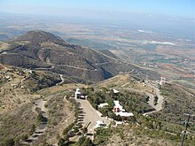
Cristo Rey is a statue on top of Cerro del Cubilete,, a 200 metres (660 ft) mountain in Silao Municipality in Guanajuato, Mexico.
The Bajío is a cultural and geographical region within the central Mexican plateau which roughly spans from northwest of Mexico City to the main silver mines in the northern-central part of the country. This includes the states of Querétaro, Guanajuato, parts of Jalisco, Aguascalientes and parts of Zacatecas, San Luis Potosí and Michoacán.
Salamanca is a city and municipality in the Mexican state of Guanajuato.
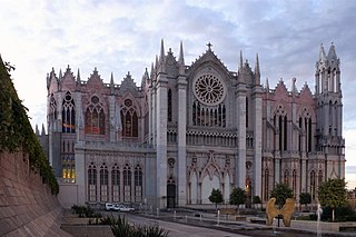
The Roman Catholic Archdiocese of León is an ecclesiastical territory or Metropolitan diocese of the Roman Catholic Church based in the Mexican city of León, Guanajuato. It currently covers an area of 41,940 km2, and has a population of 6,500,000, including the states of Guanajuato and Querétaro. It was created as the Diocese of León on January 26, 1863, by Pope Pius IX, and elevated to the rank of a metropolitan archdiocese by Pope Benedict XVI on November 25, 2006, with the suffragan sees of Celaya, Irapuato, and Querétaro.

Moroleón is a city and municipal seat of the municipality of Moroleón in the Mexican state of Guanajuato. It is near the cities of Yuriria, Morelia, and Uriangato, forming the metropolitan area of Uriangato-Moroleón with Uriangato. The municipality has an area of 164.97 km2, with an urban population of 41,909 and municipal population of 46,751 as of 2005.
Santiago Maravatío is a Mexican city located in the Bajío (lowlands) of the state of Guanajuato. With an area of 91.760 square kilometres, Santiago Maravatío accounts for less than 1% of the surface of the state. It is bordered to the north, east and southeast by Salvatierra and to the west by Yuriria.
Santa Cruz de Juventino Rosas is a Mexican city located in the central east region of the state of Guanajuato. The municipality has an area of 428.64 square kilometres and is bordered to the north by San Miguel de Allende, to the northeast by Comonfort, to the southeast by Celaya, to the south by Villagrán, and to the west by Salamanca. The municipality had a population of 65,479 inhabitants according to the 2005 census.
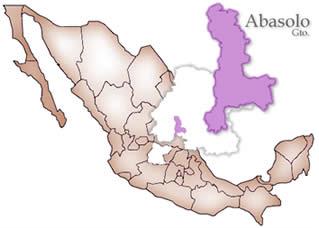
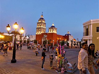
Abasolo is a Mexican city located in the Southwest region of the state of Guanajuato. The municipality has an area of 601.73 square kilometres, and is bordered to the north by Pueblo Nuevo and Valle de Santiago, to the south by the state of Michoacán and Huanímaro, and to the west by Pénjamo and Cuerámaro. The municipality had 79,093 inhabitants according to the 2005 census. The city was estimated to have 28,100 inhabitants in 2020.
Purísima del Rincón is a Mexican municipality located in the state of Guanajuato, founded on January 1, 1603. Its municipal seat is the town of Purísima de Bustos.
Huanímaro is a Mexican city located in Southwest region of the state of Guanajuato. The municipality has an area of 130.57 square kilometres and is bordered to the north and west by Abasolo, to the south by the state of Michoacán, and to the east by Valle de Santiago. The municipality had a population of 19,693 inhabitants according to the 2005 census.
Cuerámaro is a Mexican city located in Southwest region of the state of Guanajuato. The municipality has an area of 254.85 square kilometres and is bordered to the north by Romita, to the east by Abasolo, to the south by Pénjamo, and to the west by Manuel Doblado. The municipality had a population of 25,610 inhabitants according to the 2005 census.

Romita is a Mexican city located in the Southwest region of the state of Guanajuato. The municipality has an area of 442.10 square kilometres and is bordered to the north by León, to the east by Silao, to the southwest by Abasolo and Cuerámaro, and to the west by Manuel Doblado and San Francisco del Rincón. The municipality had a population of 105,825 inhabitants according to the 2005 census.

Irapuato is a Mexican city and municipality located at the foot of the Arandas Hill, in the central region of the state of Guanajuato. It lies between the Silao River and the Guanajuato River, a tributary of the Lerma River, at 1,724 m (5,656 ft) above sea level. It is located at 20°40′N101°21′W. The city is the second-largest in the state, with a population of 342,561 according to the 2005 census, while its municipality has a population of 529,440. The municipality has an area of 851 km2 (329 sq mi) and includes numerous smaller outlying communities. Although it is now an important center for regional trade and transportation center as well the site of several automotive and chemical manufacturing plants, the city's main industry has historically been agriculture and it has long been known for its strawberries and industry of refried beans, also the raising of pigs and cattle. The fruits and flowers of Irapuato's luxurious gardens are well known throughout Mexico.

The Cerro del Cubilete is a 2,700 metres (8,900 ft) tall mountain-hill in Silao Municipality in the state of Guanajuato, Mexico. At the top of the hill is the Cristo Rey statue.

Angamacutiro is a municipality in the Mexican state of Michoacán. It is located in the far north portion of the state and its municipal seat is the city of Angamacutiro de la Unión. The name "Angamacutiro" originates from the Uapeani, Pauacume, and Tariácuri native indigenous languages, where it denotes "place on the edge of the canyon" or "lugar al borde de la barranca." This name highlights the region's proximity to a canyon's cliff edge, which is a reflection of its geographic features.

Volkswagen de México S.A. de C.V. is the Mexican subsidiary of Volkswagen Group. It operates the Mexican plants of Volkswagen Group and the leasing company Volkswagen Leasing S.A. de C.V., and Volkswagen Bank S.A. Institución de Banca Múltiple. The company is headquartered in Puebla City.