
Belfry is a census-designated place (CDP) in Carbon County, Montana, United States. It is part of the Billings, Montana Metropolitan Statistical Area. The population was 218 at the 2010 census. It is located approximately 11 miles (18 km) from the Wyoming border, roughly halfway between Billings, Montana and Cody, Wyoming.
Fromberg is a town in Carbon County, Montana, United States. As of the 2020 census, the population of the town was 392.
Joliet is a town in Carbon County, Montana, United States. It is part of the Billings, Montana Metropolitan Statistical Area. The population was 577 at the 2020 census.

Belt is a town in Cascade County, Montana, United States. The population was 510 according to the 2020 census. It is part of the Great Falls, Montana metropolitan area.

Big Arm is a census-designated place (CDP) in Lake County, Montana, United States. The population was 177 at the 2010 census, up from 131 in 2000.
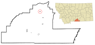
Jackson is an unincorporated community in Beaverhead County, Montana, United States. Jackson has a post office with a ZIP code 59736. As of the 2020 census, Jackson had a population of 36.
Boyd is a census-designated place and unincorporated community in Carbon County, Montana, United States. As of the 2010 census it had a population of 35. Boyd was a stop on the Northern Pacific Railway en route to Red Lodge. A post office was first established at Boyd on March 12, 1909 with Roland N. Doughty as the town's first postmaster. Since December 3, 1965, the office has operated as a rural station or a CPO of Roberts with the ZIP code of 59013.
Edgar is a census-designated place and unincorporated community in Carbon County, Montana, United States. As of the 2010 census it had a population of 114. Edgar has a post office with a ZIP code 59026. The post office was established May 28, 1909 with John J. Thornton as its first postmaster. Thornton named the town after his brother.
Roscoe is a census-designated place and unincorporated community in Carbon County, Montana, United States. As of the 2010 census it had a population of 15. Roscoe depends on light tourism and features a guest ranch, the Pioneer Pottery, and the Grizzly Bar & Grill.
Rockvale is an unincorporated community in Carbon County, Montana, United States. It is currently the site of a bar and casino, and some homes. Little remains of the original town site except the nearby cemetery.
Pray is a census-designated place and unincorporated community in Park County, Montana, United States, in the Paradise Valley. The town was founded in 1907 by Valentine Eggar, an entrepreneur. He named it after Congressman Charles Nelson Pray. Its population was 681 as of the 2010 census. Pray has a post office with ZIP code 59065, which opened on December 8, 1909.
Crane is a census-designated place and unincorporated community in Richland County, Montana, United States. Its population was 102 according to the 2010 census. Crane has a post office with the ZIP code 59217. Montana Highway 16 passes through Crane.
Whitewater is a census-designated place and unincorporated community in Phillips County, Montana, United States. Its population was 64 as of the 2010 census. Whitewater has a post office with ZIP code 59544.
Brady is a census-designated place and unincorporated community in Pondera County, Montana, United States. Its population was 140 as of the 2010 census. Brady has a post office with ZIP code 59416. The community is located along Interstate 15.
Dupuyer is a census-designated place and unincorporated community in Pondera County, Montana, United States. Its population was 86 as of the 2010 census. The community is located along U.S. Route 89 and Dupuyer Creek. Dupuyer has a post office with ZIP code 59432.
Sand Coulee is a census-designated place and unincorporated community in Cascade County, Montana, United States. Its population was 212 as of the 2010 census. Sand Coulee has a post office with ZIP code 59472.
Stockett is a census-designated place and unincorporated community in Cascade County, Montana, United States. Its population was 169 as of the 2010 census. Stockett has a post office with ZIP code 59480.
Kila is a census-designated place and unincorporated community in Flathead County, Montana, United States. Its population was 392 as of the 2010 census. Kila has a post office with ZIP code 59920, which opened on May 27, 1901. The community is located along U.S. Route 2, 10 miles from Kalispell.
Marion is a census-designated place and unincorporated community in Flathead County, Montana, United States. Its population was 886 as of the 2010 census. Marion has a post office with ZIP code 59925.
Olney is a census-designated place and unincorporated community in Flathead County, Montana, United States. Its population was 191 as of the 2010 census. Olney has a post office with ZIP code 59927. The most recent 2020 census states the population is 146 according to census.gov. The community is located along U.S. Route 93.


