
The geothermal areas of Yellowstone include several geyser basins in Yellowstone National Park as well as other geothermal features such as hot springs, mud pots, and fumaroles. The number of thermal features in Yellowstone is estimated at 10,000. A study that was completed in 2011 found that a total of 1,283 geysers have erupted in Yellowstone, 465 of which are active during an average year. These are distributed among nine geyser basins, with a few geysers found in smaller thermal areas throughout the Park. The number of geysers in each geyser basin are as follows: Upper Geyser Basin (410), Midway Geyser Basin (59), Lower Geyser Basin (283), Norris Geyser Basin (193), West Thumb Geyser Basin (84), Gibbon Geyser Basin (24), Lone Star Geyser Basin (21), Shoshone Geyser Basin (107), Heart Lake Geyser Basin (69), other areas (33). Although famous large geysers like Old Faithful are part of the total, most of Yellowstone's geysers are small, erupting to only a foot or two. The hydrothermal system that supplies the geysers with hot water sits within an ancient active caldera. Many of the thermal features in Yellowstone build up sinter, geyserite, or travertine deposits around and within them.
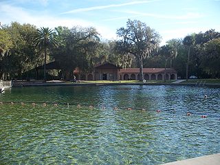
De Leon Springs State Park is a Florida State Park in Volusia County, Florida. It is located in DeLeon Springs, off CR 3.

Indiana Dunes State Park is an Indiana State Park located in Porter County, Indiana, United States, 47 miles (75.6 km) east of Chicago. The park is bounded by Lake Michigan to the northwest and is surrounded by as well as within the authorized boundaries of Indiana Dunes National Park, a unit of the National Park Service; the NPS owns the water from the ordinary high water mark to 300 feet (91 m) offshore. The 1,530-acre (619.2 ha) Dunes Nature Preserve makes up the bulk of eastern part of the park, and includes most of the park's hiking trails and dune landscape. This was one of the first places Richard Lieber considered when establishing the Indiana State Park system. Like all Indiana state parks, there is a fee for entrance. Indiana Dunes State Park was established in 1925 and designated a National Natural Landmark in 1974.

The Ocala National Forest is the second largest nationally protected forest in the U.S. State of Florida. It covers 607 square miles (1,570 km2) of northern Florida. It is located three miles (5 km) east of Ocala and 16 miles (26 km) southeast of Gainesville. The Ocala National Forest, established in 1908, is the oldest national forest east of the Mississippi River and the southernmost national forest in the continental U.S. The word Ocala is thought to be a derivative of a Timucuan term meaning "fair land" or "big hammock". The forest is headquartered in Tallahassee, as are all three National Forests in Florida, but there are local ranger district offices located in Silver Springs and Umatilla.
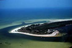
Anclote Key is a barrier island off the Gulf Coast of the U.S. state of Florida, the largest island in the Anclote Keys, located at 28°11′16″N82°50′44″W near Tarpon Springs. Its name originates from the Spanish term for "anchor." The island is accessible only by boat and is split between Anclote Key Preserve State Park and Anclote National Wildlife Reserve. North Anclote Bar, South Anclote Bar, and Three Rooker Island are part of Anclote Key Preserve State Park. The island contains mangrove wetlands, coastal pine flatwoods, and beaches. A large number of shorebirds nest and breed on Anclote Key and the surrounding islands. Sand Key is located nearby. Most of the island is located within Pasco County, while its southernmost section is in Pinellas County. The island is home to the Anclote Keys Light.

Osceola National Forest is a National Forest located in northeast Florida.
Lake Talquin is a reservoir located on the Ochlockonee River between Leon County and Gadsden County in north Florida. The lake, located about 10 miles (15 km) west of Tallahassee, is south of Interstate 10 and bordered by State Road 20 on the east and State Road 267 on the west.

Rainbow Springs State Park is a Florida state park located on U.S. 41, 3 miles (5 km) north of Dunnellon, Florida. It comprises 1,459.07 acres (5.9046 km2) upland and 12.83 acres (51,900 m2) submerged. The most significant natural feature is the first-magnitude headspring basin, which produces up to 600,000,000 US gallons (2,300,000 m3) of fresh water per day, forming the Rainbow River. The looking-glass waters of Rainbow Springs come from several vents, not one large bubbling spring. The river itself supports a wide variety of fish, wildlife, and plants, many within easy viewing by visitors. In total, the park contains 11 distinct natural communities, including sandhills, flatwoods, upland mixed forests, and hydric hammocks.

The Juniper Prairie Wilderness is a protected wilderness area in the Ocala National Forest in Florida, United States.

Wild Waters was a Water park in Silver Springs, Florida. It was the sister park of Silver Springs Nature Theme Park in Silver Springs. Because Wild Waters was adjacent to Silver Springs, it had many trees and shady areas. There were picnic areas, a snack bar, and an open-air fast food restaurant counter. The park also had a sand volleyball court and a gift shop.

Juniper Springs, located in the Ocala National Forest east of Ocala, Florida, is a natural spring that forms the headwaters of Juniper Creek that winds its way to Lake George in the Saint Johns River.

Sand boils, sand volcanoes, or sand blows occur when water under pressure wells up through a bed of sand. The water looks like it is boiling up from the bed of sand, hence the name.

The Rainbow River is located in Dunnellon, Florida, United States, in the southwest corner of Marion County, about 20 miles (32 km) southwest of Ocala, 100 miles (160 km) northwest of Orlando and 100 miles (160 km) north of the Tampa Bay area. It is formed by a first-magnitude spring that is ranked fourth in the state for volume of discharge. In addition to the springs located at the headwaters, there are many smaller springs that discharge from numerous caves, rock crevices, and sand boils the entire length of the river.

The Silver River is a short spring-fed river located east of Ocala in Marion County, Florida. Fed by Silver Springs, it connects the springs to the Ocklawaha River, passing through a pristine woodland environment. The river was probably named for its silvery appearance.
Natural Falls State Park is a 120 acres (0.49 km2) state-owned park in the Ozarks, in Delaware County, Oklahoma. It lies along U.S. Highway 412, near the Arkansas-Oklahoma state line. The property was privately-owned and known as Dripping Springs until 1990, when the state bought it. The previous owners had also used the property as an attraction and rest stop for travelers on the highway, featuring a swimming pool and gardens. The site was used in the production of the 1974 film "Where the Red Fern Grows".
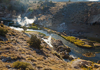
Hot Creek, starting as Mammoth Creek, is a stream in Mono County of eastern California, in the Western United States. It is within the Inyo National Forest.

The Ochoco Mountains are a mountain range in central Oregon in the United States, located at the western end of the Blue Mountains. They were formed when Permian, Triassic, and Jurassic rocks were slowly uplifted by volcanic eruptions to form the Clarno Formation. Today, the highest point in the range is Lookout Mountain. The dominant vegetation on the west side of the range is old-growth ponderosa pine; on the east side, western juniper is common. The western area of the mountains is administered by the Ochoco National Forest, while the southeastern section is part of the Malheur National Forest. The Ochoco Mountains are used for hiking, camping, bird watching, rockhounding, and hunting, as well as cross-country skiing in the winter.

The Lost Forest Research Natural Area is a designated forest created by the Bureau of Land Management to protect an ancient stand of ponderosa pine in the remote high desert county of northern Lake County, in the south central area of the U.S. state of Oregon. Lost Forest is an isolated area of pine trees separated from the nearest contiguous forest land by forty miles of arid desert. There are no springs or surface water in Lost Forest, and much of the southwest portion of the natural area is covered by large shifting sand dunes that are slowly encroaching on the forest.
Orange Creek is a small stream in north-central and northeast Florida, that drains Orange Lake to the Ocklawaha River. Privately owned Orange Springs provides part of the water volume.

Monument Valley Park is a historic, recreational park in Colorado Springs, Colorado through which Monument Creek flows. It is a National Register of Historic Places listing and is on the Colorado State Register of Historic Properties.


