
Gunsan, also romanized as Kunsan, is a city in North Jeolla Province, South Korea. It is on the south bank of the Geum River just upstream from its exit into the Yellow Sea. It has emerged as a high-tech manufacturing industrial city and an international trade seaport that is approximately 200 km (120 mi) southwest of Seoul on the midwest coast of the Korean Peninsula.

Jecheon is a city in North Chungcheong Province, South Korea. The city is a major railway junction or a transportation mecca, served by the Jungang, Chungbuk and Taebaek Lines. Jecheon has scenic surroundings and several tourist spots like the Uirimji Reservoir, Cheongpung Lake and Cheongpung Cultural Properties complex. It is also the home of Semyung University.

Wonju is the most populous city in Gangwon Province, South Korea, with a population of 364,860 as of 2023. The city is located approximately 140 kilometres (87 mi) east of Seoul. During the time of Great Joseon, Wonju was the capital of the historic Gangwon Province, one of the Eight Provinces of Korea. It was the site of three crucial battles during the Korean War.

Jangheung County is a county in South Jeolla Province, South Korea.
Wando County is a county in South Jeolla Province, South Korea. It takes its name from the island of Wando, which is the largest island within the county and serves as the county seat. Wando island is perhaps most famous for Cheonghaejin, the former headquarters of Jang Bogo, a 9th-century Korean historical figure whose private fleet and army dominated the sea routes in the Yellow Sea. Wando's most famous native in modern times is champion golfer K.J. Choi.
Yeonggwang County (Yeonggwang-gun) is a county in South Jeolla Province, South Korea.

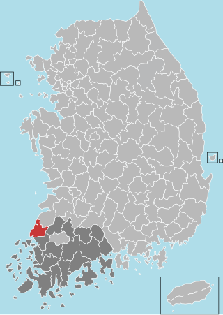
Buan County (Buan-gun) is a county in Jeonbuk Sate, South Korea. It is bounded by the city of Jeongeup on the east, the county of Gochang on the south, the city of Gimje on the north, and Yellow Sea on the west. Buan is divided into 1 eup, 12 myeon, and 510 ri. Buan had a 2001 estimated population of 74,716 people and a 2018 population of 54,441 people with an area of 493.35 km2. Famous people from Buan include Joseon Dynasty kisaeng and poet, Yi Mae-chang. Like many rural areas in southern Korea, it has seen shrinking population with many younger people moving north to larger cities such as Seoul. This county should not be confused with Muan, the new capital of South Jeolla Province.

Changwon is the capital and largest city of Gyeongsangnam-do, South Korea, and the 11th largest city of the country.

Chuncheon is the capital of Gangwon Province in South Korea. The city lies in the north of the county, located in a basin formed by the Soyang River and Han River. There are some large lakes around the city, most notably Soyang Lake and Uiam Lake. The area has small river islands, such as Sangjungdo, Ha-Jungdo, Bungeodo, and Wido.

Gapyeong County (Korean: 가평군) is a county in Gyeonggi Province, South Korea. It was the scene of the Battle of Kapyong, a major battle of the Korean War.

Cheongyang County is a county in South Chungcheong Province, South Korea. A predominantly rural area, it is known throughout Korea for the spicy Cheongyang chili peppers which are grown there. Another noted local specialty is the fruit of the gugija. The county is home to Cheongyang Provincial College.

Seocheon County is a county in Chungcheongnam-do, South Korea. It is famous for its seafood and location near the mouth of the Geum River.
Geochang County is a county in South Gyeongsang Province, South Korea. The Geochang International Festival of Theater, which was started in 1989, is renowned as the best play festival in Korea. The District Office is located in Geochang-eup, and has jurisdiction over 1 eup and 11 myeon.

Namhae County (Namhae-gun) is a county in South Gyeongsang Province, South Korea.

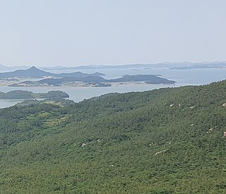
Heuksando (Korean: 흑산도) is an island in the Yellow Sea located off 97.2 km from the southwest coast of Mokpo, Jeollanam-do, South Korea. It covers an area of 19.7 km2 and consists of several peaks: Munamsan, Gitdaebong, Seonyubong, Sangnasan. It is within the administrative boundaries of Sinan County, Jeollanam-do, South Korea since 1969. The island's 19.7 km2 are home to about 3,133 people.

Slavery on Sinan County's salt farms relates to the discovery of human trafficking cases in Sinan County (신안군), Jeollanam-do (전라남도), South Korea in 2014. It was discovered that individuals, mostly the homeless, were kidnapped and sent to salt farms to work without any compensation.

Oido (Korean: 오이도) is an island on the West Coast region of South Korea's Gyeonggi Province. It is an area of Siheung stretching from north to south with low hills under 72.9 m (239 ft). Oido has shell mounds throughout the whole area, with the largest of the mounds located on the West Coast. The Oido shell mounds are the only remains of the exchanges between the North and South Neolithic cultures of the Korean Peninsula. The mounds also provide information on the Neolithic area's changing coastal environment.
Amtaedo is the sixth largest island in Sinan County, South Jeolla Province, South Korea. The island lies in the Yellow Sea about 25 km west of Mokpo, South Jeolla Province, South Korea. The highest peak on Amtaedo is Seungbong mountain (승봉산), which stands at 355 meters above sea level. In the past it was only possible travel to Amtaedo by a ferry departing from the Mokpo Coast Ferry Terminal. However, on April 4, 2019 the Angel Bridge (천사대교) was completed connecting Amtaedo with the island of Aphaedo (압해도). Since Aphaedo is connected to the mainland by two bridges, it is now possible to drive to Amtaedo by car. The neighboring islands of Jaeundo (자은도), Palgeumdo (팔금도) and Chupodo (추포도) are connected to Amtaedo by bridges.

The Shinan ship was a 14th-century Chinese ship that sank near what are today the Shinan islands, South Korea, around the year 1323, and was discovered in 1975. It was likely to have been part of a trade fleet between Port Ningbo, Yuan dynasty China and Port Hakata, Kamakura shogunate of Japan.

Anjwa-myeon, is a myeon located in Shinan County, South Jeolla, South Korea. It has an area of 59.97 km2 and its population in March 2022 was 3,071. The myeon is composed of 63 islands, 10 inhabited and 53 uninhabited. Its largest island is Anjwa Island, which comprises the majority of its land area. This island is also the largest island of Shinan County. Its northern coast is connected by a bridge to neighboring Palgeum-myeon, while to west of the island lies Bigeum-myeon. To the southwest of the myeon lies Haui-myeon, whilst Jangsan-myeon lies to its southeast.


