U.S. Route 1 or U.S. Highway 1 (US 1) is a major north–south United States Numbered Highway that serves the East Coast of the United States. It runs 2,370 miles (3,810 km) from Key West, Florida, north to Fort Kent, Maine, at the Canadian border, making it the longest north–south road in the United States. US 1 is generally paralleled by Interstate 95 (I-95), though US 1 is significantly farther west (inland) between Jacksonville, Florida, and Petersburg, Virginia, while I-95 is closer to the coastline. In contrast, US 1 in Maine is much closer to the coast than I-95, which runs farther inland than US 1. The route connects most of the major cities of the East Coast from the Southeastern United States to New England, including Miami, Jacksonville, Raleigh, Richmond, Washington D.C., Baltimore, Philadelphia, New York City, and Boston.

Interstate 95 (I-95) is the main north–south Interstate Highway on the East Coast of the United States, running from U.S. Route 1 (US 1) in Miami, Florida, north to the Houlton–Woodstock Border Crossing between Maine and the Canadian province of New Brunswick. The highway largely parallels the Atlantic coast and US 1, except for the portion between Savannah, Georgia, and Washington, D.C., and the portion between Portland and Houlton in Maine, both of which follow a more direct inland route.

Prince George County is a county located in the Commonwealth of Virginia. As of the 2020 census, the population was 43,010. Its county seat is Prince George.

Hardeeville is a city in Jasper and Beaufort counties in the U.S. state of South Carolina. The population was 7,473 as of the 2020 census, an increase of over 150% since 2010. Hardeeville is included within the Hilton Head Island–Bluffton metropolitan area.

Stony Creek is a town in Sussex County, Virginia, United States. The population was 198 at the 2010 census.
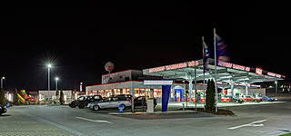
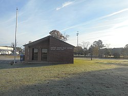
A rest area is a public facility located next to a large thoroughfare such as a motorway, expressway, or highway, at which drivers and passengers can rest, eat, or refuel without exiting onto secondary roads. Other names include motorway service area (UK), services (UK), travel plaza, rest stop, oasis (US), service area, rest and service area (RSA), resto, service plaza, lay-by, and service centre (Canada). Facilities may include park-like areas, fuel stations, public toilets, water fountains, restaurants, and dump and fill stations for caravans / motorhomes.
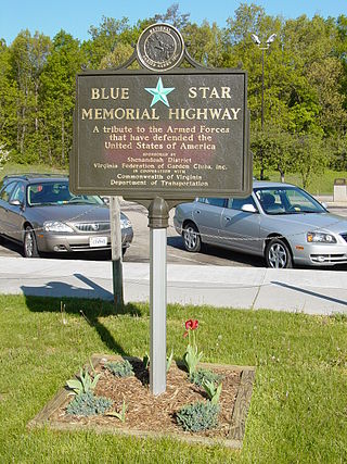
Blue Star Memorial Highways are highways in the United States that are marked to pay tribute to the U.S. armed forces. The National Council of State Garden Clubs, now known as National Garden Clubs, Inc., started the program in 1945 after World War II. The blue star was used on service flags to denote a service member fighting in the war. The program has since been expanded to include Memorial Markers and Memorial By-ways. These markers are used in National Cemeteries, parks, veterans facilities, and gardens.

U.S. Route 301 (US 301) is a spur of U.S. Route 1 running through the South Atlantic States. It runs 1,099 miles (1,769 km) from Biddles Corner, Delaware, at Delaware Route 1 to Sarasota, Florida, at U.S. Route 41. It passes through the states of Delaware, Maryland, Virginia, North Carolina, South Carolina, Georgia, and Florida. It goes through the cities of Middletown, Delaware; Annapolis, Maryland; Richmond and Petersburg, Virginia; Rocky Mount, Wilson, and Fayetteville, North Carolina; Florence, South Carolina; Statesboro and Jesup, Georgia; and Ocala, Zephyrhills, and Sarasota, Florida.
The Richmond–Petersburg Turnpike was a toll road located in the Richmond-Petersburg region of central Virginia, United States.

Breezewood is an unincorporated town in East Providence Township, Bedford County in south-central Pennsylvania, United States.

State Route 161 is a primary state highway in and near Richmond, Virginia, United States. It extends from an interchange with Interstate 95 (I-95) in the independent city of Richmond north to an intersection with U.S. Route 1 in the Lakeside area of central Henrico County.
Interstate 95 (I-95) runs 179 miles (288 km) within the commonwealth of Virginia between its borders with North Carolina and Maryland. I-95 meets the northern terminus of I-85 in Petersburg and is concurrent with I-64 for three miles (4.8 km) in Richmond. Although I-95 was originally planned as a highway through Washington, D.C., it was rerouted along the eastern portion of the Capital Beltway concurrent with I-495. From Petersburg to Richmond, I-95 utilized most of the Richmond–Petersburg Turnpike, a former toll road. In addition to Richmond, the route also runs through the medium-sized cities of Emporia, Petersburg, Colonial Heights, Fredericksburg, and Alexandria.
Interstate 95 (I-95) is a part of the Interstate Highway System that parallels the East Coast of the United States from Miami, Florida, in the south to Houlton, Maine, in the north. In the US state of Massachusetts, it spans 92 miles (148 km) along a north–south axis. It is the third-longest Interstate Highway in Massachusetts, behind I-90 and I-495, while I-95 in full is the longest north–south Interstate and sixth-longest Interstate Highway in the US.
Interstate 95 (I-95) is a part of the Interstate Highway System that runs along the East Coast of the United States from Miami, Florida, to the Canadian border in Houlton, Maine. In the state of North Carolina, the route runs for 181.36 miles (291.87 km) from the South Carolina border near Rowland to the Virginia border near Pleasant Hill. The highway serves the cities of Lumberton, Fayetteville, Wilson, Rocky Mount, and Roanoke Rapids. The route goes through a mostly rural area of the state, avoiding most of the major metro areas of North Carolina. It forms the informal border between the Piedmont and Atlantic Plain regions of the state.

Interstate 95 (I-95) is a major Interstate Highway, running along the East Coast of the United States from Florida to Maine. In South Carolina, I-95 runs approximately parallel to the Atlantic Ocean shore although about 50 miles (80 km) inland, from Hardeeville in the south to Dillon in the northeast. The route runs through the cities of Florence and Walterboro.
U.S. Route 301 is a part of the U.S. Highway System that runs from Sarasota, Florida, to Biddles Corner, Delaware. In Virginia, the U.S. Highway runs 142.70 miles (229.65 km) from the North Carolina state line near Skippers north to the Maryland state line at the Potomac River near Dahlgren. US 301 forms the local complement to Interstate 95 (I-95) from Emporia to Petersburg. The U.S. Highway runs concurrently with US 1 between Petersburg and the state capital of Richmond, where the highways form one of the main north–south avenues. US 301 continues north concurrent with Virginia State Route 2 to Bowling Green, forming an eastern alternative to I-95 and US 1 north of Richmond. At Bowling Green, which is connected to I-95 by SR 207, US 301 becomes the primary highway connecting Richmond and the Northern Neck with Southern Maryland. US 301 was constructed in four main segments: as the original SR 24 and then US 17-1 south of Petersburg, as US 1 from Petersburg to Richmond, as SR 2 from Richmond to Bowling Green, and as part of SR 207 toward Dahlgren. US 301 replaced US 17–1 in the early 1930s and was extended from Petersburg north along its current course into Maryland when the Potomac River Bridge was completed in 1940.

State Route 40 is a primary state highway in the southern part of the U.S. state of Virginia. It runs from SR 8 at Woolwine east to SR 10 at Spring Grove, about half the width of Virginia. It is the longest state-numbered route in Virginia.
U.S. Route 301 (US 301) is a north–south United States highway that runs for 194 miles (312 km) in North Carolina from the South Carolina state line near Rowland to the Virginia state line near Pleasant Hill. The entire route parallels I-95. From the southern border to Hope Mills, it runs very close to I-95, crossing it several times and having a short concurrency with the freeway in Lumberton. From Hope Mills to Eastover, North Carolina it follows Interstate 95 Business, a partial freeway that passes through the center of Fayetteville. Passing through towns such as Dunn, Benson, Smithfield, and Selma that are bypassed by I-95, numerous local businesses targeted at I-95 travellers line this stretch, rarely does it veer more than a fraction of a mile from I-95. At Kenly, it leaves its close parallel of I-95, taking a route approximately 5 miles east of I-95 and passing through the center of the cities of Wilson and Rocky Mount. North of Rocky Mount it passes through several small towns, including Whitakers, Enfield, Halifax, and Weldon before passing into Virginia near Pleasant Hill. Through Rocky Mount the route divides into a Business and Bypass route, and there is also a short business loop in Halifax.
Moonlight is an unincorporated community in Greensville County, Virginia, United States. It is located north of Emporia along US 301 approximately near the vicinity of Exits 12 and 13 off of Interstate 95.

South Carolina Highway 341 (SC 341) is a 93.870-mile (151.069 km) state highway that travels through the northeastern part of the U.S. state of South Carolina. It travels diagonally from the southeast to northwest from SC 41 and SC 51 in Johnsonville to U.S. Route 521 Business and US 601 Bus. in Kershaw.